While there are lots of places on the Internet that it’s wise to avoid, there are many other sites that are well worth a visit. One of those sites that I’ve been having lots of fun with during the past several months is the “Oswego Then and Now” page on Facebook.
The site is a haven for those nostalgic for the Oswego that was, especially those who’ve moved away, as well as a fun and friendly place for current residents to reconnect with old friends, reminisce about the village’s past, and—even for us natives—learn new things about the area. It’s networking at its very best.
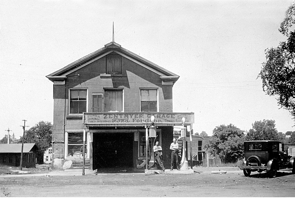
The east side of Main between Washington and Jackson streets in 1958 just as Oswego was beginning its first major growth spurt since the 1830s and changing from catering to the surrounding agricultural area to becoming an ever-expanding suburban community. (Little White School Museum collection)
A recurring theme for many posters is alarm and, often, dismay and even anger at the profound changes the community has undergone, especially during the past 60 years or so. Which is understandable, given Oswego’s population has multiplied 20 times during that period, irrevocably turning the community from the small farm town it was to the still-growing suburban community it is today.
For those of us who have continually lived in the community longer than that 50-year time period, however, the growth has definitely been surprising, but is only truly new in the shear amount of it recently.
Because Oswego, its surrounding township, and Kendall County itself actually began a radical change from its former overwhelmingly rural character to a fast-growing urbanizing area soon after World War II ended.
The era of rapid change developed due to a few factors, the first three of which, as real estate dealers always insist on putting it, were location, location, location. The city of Chicago is the engine that powers growth in northern Illinois, especially the extreme post-World War II urbanization that quickly spread to the six collar counties surrounding the city and its county of Cook.
Kendall County is the only non-Collar County that borders on three of the Collar Counties surrounding Chicago and Cook County. This made it a target for profound growth and change after World War II.
Kendall, you see, is the only non-collar county that borders three—Kane, DuPage, and Will—of those fast-growing areas.
Couple Kendall County’s location, location, location with the modernization of the region’s road system that began after World War I and the advent and perfection of economical, dependable motor vehicles from cars to buses to trucks, plus the technological agricultural advances that meant fewer farmers and less farmland were required to produce ever-increasing amounts of crops and livestock on less and less land, and you’ve created a recipe for profound change. And keep in mind that change doesn’t always lead to growth.
All it needed was a kick to get our small corner of Illinois’ growth started, and that was provided by the post-World War II economic boom of the 1950s. That was fueled by the largest governmental aid programs in history, known as the G.I. Bills. The young men and women returning home after the war were hungry to start their own families and buy their own homes. Also, many of them looked to further their educations in order to get ahead in increasingly corporate America. And the G.I. Bills funded both of those things, at least for most of those who had served.
The county’s population boom started here in northeastern Kendall County with the sprawling Boulder Hill Subdivision, a planned community fueled mainly by low-interest G.I. loans and supported by industrial expansion by giant manufacturing firms ranging from Caterpillar, Inc. to AT&T, not to mention long-established area firms from All-Steel to Equipto to Lyon Metal to Barber-Greene.
Model homes on Briarcliff Road in Boulder Hill in September 1958 appealed to those eligible for G.I. Loans, with no money down and low interest rates. (Photo by Bev Skaggs in the collections of the Little White School Museum)
That first tranche of growth from the mid-1950s through the 1970s created the first major change as the Oswego area saw itself change from dependent on providing agricultural support services to becoming a bedroom community, the vast majority of whose residents had no connection with farming at all. Instead, they commuted not just out of Oswego but also north and east out of Kendall County to staff the Fox Valley’s surging industrial base.
And that was about the time I got into the local journalism business, first as a historical columnist for the old Fox Valley Sentinel and then in 1980 becoming the editor of the Ledger-Sentinel after the Sentinel and Oswego Ledger merged.
In fact, the single biggest news story we covered for the next several decades after the Ledger-Sentinel was established was growth and the profound changes it wrought in Oswego and the rest of Kendall County and the Fox Valley.
My interest in how local history dovetailed with what was happening in the rest of North America and the world gave me, I think, a useful perspective on what was happening here in the Fox Valley.
Change, it was clear, was the most important governing historical factor and had been for centuries. The cultures of the region’s indigenous people had constantly undergone change since they had arrived as the last Ice Age ended. Their descendants, then, were forcibly displaced by the White descendants of European colonists who had arrived on the Atlantic coast in the 16th, 17th and 18th centuries.
In the Treaty of Chicago, signed in 1833, the indegenous people of northern Illinois signed away the rest of their rights to their lands. It would lead, in three years, to the tribes being forced to remove west of the Mississippi River to secure the region for White settlement. (“The Last Council of the Pottawatomies, 1833,” by Lawrence C. Earle, 1902)
Illinois’ inclusion in the new United States was partially confirmed as the result of the Revolutionary War, and was finally assured by the treaty ending the War of 1812. The various wars with the region’s indigenous people that finally ended in northern Illinois in 1832 resulted in their forcible expulsion to areas west of the Mississippi River. And that, in turn, opened the region to the flood of White settlement that forever changed the area’s very landscape.
The U.S. Civil War of the 1860s also had a profound effect on the Fox Valley. Even though fighting took place hundreds of miles away, nearly 10 percent of the county’s entire population served, and more than 200 died. The end of the war saw Kendall County’s population steadily decline during the next century due to a number of factors. Among those factors was the 1862 Homestead Act that used the lure of free land to persuade farmers to head west to try their luck on the trans-Mississippi shortgrass prairies.
Not until the next historical inflection point was reached after World War II did the character of the county and, especially, our corner of it begin to profoundly change once again.
Downtown Oswego immediately after World War II, where businesses primarily catered to the surrounding agricultural area was about to begin an era of change that is still taking place today. (Little White School Museum collection)
And so here we find ourselves looking back on what proved to be a period of extraordinary, sometimes chaotic social, economic, and population change as what so many of us remember as the unchanging halcyon days of our youth. Because Oswego’s always been a great place for kids to grow up; it’s still one of the safest towns in Illinois. And besides, when we were kids, our parents were the ones who did the worrying.
These days, Oswego’s Little White School Museum has become the main repository where as many pieces of the area’s history and heritage as possible are being collected, safely stored, and interpreted before they’re lost forever. The collection keeps growing as us volunteers frantically work to save as much Oswego history as we can before it’s either paved over or pitched into a Dumpster.
So with those aims in view, at noon this coming Saturday, May 4, the museum—located at 72 Polk Street in Oswego—will host another program dedicated to chronicling some of that disappearing history. As its title suggests, “Lost Oswego” will be look at the community landmarks that have been lost through the years, losses that in many cases are far from recent. In addition, the program will recount some of the community’s public and private preservation successes that are helping remind us of the Oswego area’s rich history and heritage.
The program’s sponsored by the museum and the Oswegoland Heritage Association. Admission will be $5, with proceeds going to benefit the museum’s operations. Reservations can be made by calling the Oswegoland Park District at 630-554-1010 or visiting the museum program page at bit.ly/LWSMPrograms—or you can walk in on Saturday and pay at the door.
I was working on the “Lost Oswego” presentation I’m scheduled to give on Saturday, May 4, at the Little White School Museum here in Oswego when I decided to include a few architectural preservation successes the community has enjoyed.
The program is mostly about the landmarks we’ve lost over the years, a process of change that began a few decades after Oswego was founded and continues to the present day. But Oswego’s architectural history isn’t all bleak; there have been a few major successes, too. Chief among those, of course, is the Little White School Museum itself. Slated for demolition in the 1970s, a grassroots community effort not only saved the landmark structure, but led to its complete restoration into the community resource and treasure it is today.
Oswego’s landmark Little White School Museum is a notable Oswego preservation success. Photo by Stephanie Stekl Just.
While the Little White School Museum success was due to a private-public partnership between the not-for-profit Oswegoland Heritage Association and the Oswegoland Park District, some other Oswego landmarks have been saved by their private owners. A group of three adjoining buildings on the west side of Main Street just north of Jackson Street is a prime example of that.
Originally three separate buildings, the W.O. Parke Building, the first Oswego Community Bank, and the Durand House have been turned into a single commercial structure that enjoys a lot of community patronage.
William Oscar Parke built his two-story front-gabled landmark commercial building of native limestone in 1845 at the northwest corner of Main and Jackson streets.
The W.O. Parke building (center) as it looked about 1876. (Little White School Museum collection)
Like all of Oswego’s limestone buildings, the stone was likely quarried right in the Oswego area, which boasted a number of limestone quarries. One quarry was right behind what’s now the Oswego Public Library along Waubonsie Creek and it’s likely that’s where the stone for Parke’s building came from. Other limestone quarries were located east of the modern Ill. Route 25 bridge across Waubonsie Creek and operated by early settler Walter Loucks and on either side of Wolf’s Crossing Road just east of the original Oswego village limits, operated by Elijah Hopkins. Yet another quarry, this one specializing in flagstone of varying thicknesses, was operated by George D. Wormley on the west bank of the Fox River a couple miles upstream from Oswego. After its life as a stone quarry, the Wormley quarry property was sold to the YWCA for use as a summer camp and named Camp Quarryledge. Since those days, the parcel has had numerous owners but the old quarry, namesake of the camp, still exists.
Fred (left at wheel) and Claire Willis with their new REO Speed Wagon at their Oswego Tin Shop in the Parke Building about 1904. Note the parging is still attached to the building. (Little White School Museum collection)
In addition, the Parke Building was also parged. Parging consists of covering a building’s stone or wood siding with a relatively thin layer of mortar. While the mortar’s still wet, the mason doing the parging work scribes lines in it making it look as if the building is constructed of cut stone rather than the random-layed stone we see today when the parging has all fallen off or been otherwise removed.
Parke, a businessman and Oswego’s second postmaster, ran both his store and the post office from the building. After Parke sold the building in 1848 a number of postmasters and merchants conducted business there ranging from grocery stores, harness shops, a tinsmiths, and an auto repairs. The Oswego Post Office remained housed in the building, off and on, from the 1840s until Postmaster Lorenzo Rank moved it to the new building he erected in the middle of the block between Washington and Jackson streets in 1874.
Rank, who was also the long-time Oswego correspondent for the Kendall County Record and knowing community residents would probably complain about the change, wryly noted in the Record’s Aug. 4, 1874 “Oswego” news column: “The post office has been moved from the corner where it was in operation for about 19 years to the center of the block across the street. The inside arrangements of the new office are about as crooked as they could have been made. The change is not favorably regarded by the public.”
Oswego Postmaster Lorenzo Rank moved the Oswego Post Office from the Parke Building to his new post office in 1874. (Little White School Museum collection)
As Rank explained about Parke in the Aug. 5, 1875 Record: “W.O. Parke, or Oscar Parke as familiarly known, was in an early day one of the most energetic men and prominent merchants of this town; he was the postmaster during the administration of James K. Polk and again during a portion of that of Franklin Pierce. Intelligence of his death was received a few days ago.”
Over the next several decades, the building went through several owners and just as many uses, from a grocery store to a feed mill to a harness shop. In 1901, Oswego jeweler A.P. Werve moved his jewelry store into the ground floor of the building, while he and his family lived upstairs. Werve also bought a couple pool tables in 1902 to supplement his store. And in January 1904, Werve opened a bowling alley in the building as well. Werve was apparently quite an innovator—he custom built the first automobile in Oswego in 1903.
After Werve’s numerous uses the building was purchased by Gus Shoger and rented out for a number of uses including farm implement sales. In Sept. 1914, Fred and Clare Willis displaced the harness business in the building and moved their tinsmithing and heating business there, where they remained until Clare was called up to serve in World War I.
The W.O. Parke Building about 1927 after Earl Zentmyer moved down from Aurora and bought the old Liberty Garage that Charles Reid ran. Note the parging is still almost completely intact and that the business included gasoline pumps. (Little White School Museum collection)
Then in 1922, young Earl Zentmyer came down to Oswego from Aurora looking for an opportunity to open an auto repair business. As it happened, Charles Reid, who was operating the Liberty Garage in Gus Shoger’s stone building, was looking to sell. Shoger offered Zentmyer good rental terms and the deal was sealed. Zentmyer opened the village’s first Ford auto dealership there in 1929. In the early 1930s, he bought the stone building as well as the old livery stable across Main Street at the northeast corner of Main and Jackson, moving the dealership there after doing some extensive remodeling.
Lay-Z-Pines Driftwood Arts occupied the W.O. Parke Building in 1958. Earl Zentmyer still owned the building at the time. Note the Durand House next door with the vacant area between the two buildings. Photo by Homer Durand in the collections of the Little White School Museum.
Zentmyer continued to own the building, where a number of businesses from his son, Jim’s, post World War II appliance store to the first Rucks Appliance Store to Zentmyer’s wife’s Lay-Z-Pines Driftwood Arts gift and craft store were located.
Zentmyer owned the building until 1970, when he sold it to Jacqueline and Ken Pickerill. The Pickerills had moved their Jacqueline Shop, an upscale women’s apparel store, there from their original location on South Main Street in 1960. In 1996, the Pickerills retired and sold the building to Greg Kaleel, who today houses the Prom Shoppe women’s clothing store in the historic structure, continuing a 170 year mercantile tradition.
As far as I can determine, no structure ever bordered the stone Parke Building to the north during the 19th Century, other than a storage shed or two. Instead, a single-family home was built a short distance north, leaving a blank space.
In 1863, James A. Durand and his family moved to Oswego from their former home at the end of modern Light Road There, Durand had been the CB&Q’s first Oswego station agent, and bought what became known as the Durand House at 19 Main Street, just a short distance north of the Parke Building.
After they left Oswego in 1869, the house was rented to many Oswegoans including pioneer druggist Levi Hall and his new bride.
Oswegoan John Sanders served in the Mexican-American War in 1846. He eventually returned to Oswego and married the widow, Nancy Pearce King. The couple moved about the U.S. fairly often as Sanders engaged in businesses ranging from sliversmithing to retail merchant. They permanently returned to Oswego and bought the Durand house in 1873. Sanders progressively lost his eyesight during the next several years until he was totally blind. He died Feb. 12, 1885 and is buried in the Pearce Cemetery.
The Village Grind as depicted on the Oswegoland Heritage Association’s 2015 Cat’s Meow architectural miniature fundraiser.
During the next 106 years, the house experienced many owners and residents before 1991 when Lee and Bernie Moe opened the Village Grind Coffee & Tea Company, Oswego’s first dedicated gourmet coffee shop. The Moes sold the business to its current owners, Jodi and Dave Behrens, in 2004. Today, the Village Grind, which has been amalgamated into a block of storefronts with it and the Parke Building being sort of bookends, remains one of historic downtown Oswego’s most popular destinations.
And then there’s the building in the middle that offers a connection between the Parke and Durand buildings, the first Oswego Community Bank.
Banks in Oswego didn’t have a very successful history. The community’s first, a private bank, was established by Oswego druggist Levi Hall. As the Kendall County Record reported on Feb. 24, 1881: “It should have been mentioned heretofore that Oswego has made another progressive step and reached a very important business acquisition namely that of a bank. L.N. Hall in connection with his [drug] store is now doing a general banking business, and he has the best facilities for conducting it.” Hall’s store was located in the north storefront of the Union Block on the east side of Main Street between Washington and Jackson streets.
Oswego Community Bank under construction, June 11 1958 on Main Street just north of Jackson. Dick Young, contractor, is working on the rear wall in this photo by Homer Durand. (Little White School Museum collection)
Unfortunately, Hall became a victim of the Panic of 1893, one of the nation’s periodic economic depressions. The Panic was so serious that all three Kendall County banks failed during a two-week period that summer. Hall, an honest and contentious businessman, worked hard to try to pay back his depositors. The community didn’t get another bank until 1903 when the Oswego Banking Company opened. Eventually bought by the Burkhart family and turned into the Oswego State Bank, it failed during the Great Depression of the 1930s.
After that, it took the community nearly 30 years before they were ready to try establishing their own bank again. But local businessmen and farmers finally realized they really need a local bank. On Nov. 22, 1956, Oswego Ledger Editor Ford Lippold noted: “There is some talk about the possibility of a bank being formed in the village. This is one of the things that will be of great benefit to everyone in the community.” He followed up with this Dec. 13 note: “A public meeting is being planned for Jan. 14, 1957 to discuss the possibility of setting up a bank in Oswego, a facility that really is needed.”
The gathering turned out to be successful, Lippold reporting on Jan. 17: “A good group of Oswegoans turned out for the meeting in the Community Room Monday night to discuss the possible formation of a bank in Oswego. There was a general feeling in the group of a definite need for a bank in Oswego and a steering committee is being formed to lay the groundwork for the possible organization of a bank on a community basis.”
The small but tidy interior of the Oswego Community Bank when it opened in downtown Oswego in 1958. (Little White School Museum collection)
Talks with potential corresponding banks and attorneys continued and on April 4, 1957, the Ledger reported: “G.C. Bartholomew, chairman of the organizing committee for the new Oswego bank reports that the number of necessary forms pertaining to the organization of the bank have been completed by the following organizers: Homer Brown, Dr. Sheldon Bell, John Cherry, Charles Lippincott, Myron Wormley, Earl Zentmyer and G.C. Bartholomew.”
The idea was for the new institution to be a true community bank, Lippold noting in the April 25 Ledger that “Present plans are to have the shares of stock in the new bank sell at a low cost each so that everyone will have an opportunity to be a part of the new organization. A limit will be placed on the amount of stock that any one person can own.”
From there, plans moved forward quickly with tens of thousands of dollars being subscribed in the proposed bank by Oswego residents. Lippold was somewhat surprised at the positive attitude of so much of the community towards the new bank given the normal negativity towards just about anything new, noting on Oct. 10, 1957: “It’s been a long time since there’s been so much interest in anything in the community as there is in the new Oswego Community Bank and, for a change, the comments are mostly favorable. Oh, there are a few diehards who say it will never go, but they are the same ones who said the auto would never replace the horse. Back to the easy chairs, boys, lay down and roll over, you’re dead.”
The Oswego Community Bank shortly after it opened in August 1958 at its original Main Street location, sharing its south wall with the W.O. Parke Building’s north wall. Note the unfinished drive for the drive-up window at right. (Little White School Museum collection)
On March 13, 1958 the Ledger reported that Oswego contractor Richard Young had broken ground on March 9 for the new bank building on Main Street just north of Jackson Street, adjacent to the Parke Building. It was hoped construction would be completed in 120 days, according to bank officials. In addition, seven local residents were elected to the bank’s first board of directors including George. C. Bartholomew, John Cherry, Myron Wormley, Sheldon Bell, Charles Lippincott, Earl J. Zentmyer, and Homer Brown.
As planned, the new 1,700 square foot building included a first floor plus a full basement. The vault, with a capacity of 1,050 safe deposit boxes, was built of 18″ thick steel reinforced concrete.
The bank opened on Aug. 30, 1958, the Ledger reporting: “Among the many features offered in this well-planned, air conditioned building are a modern vault ample teller facilities, safety deposit boxes, drive-up window, safety alarm system, day and night depository, and a customer parking lot. A spacious basement area is available for employees’ comfort and for future expansion as the Oswegoland community continues to grow.”
The W.O. Parke Building after it became the home of the up-scale women’s clothing store, the Jacqueline Shop. This photo was taken in the early 1980s after the Oswego Community Bank had moved out and Jacquie and Ken Pickerill expanded into that space. The mansard canopy across the front was added in the mid-1970s. (Little White School Museum collection)
Wrote Lippold in an Aug. 28 Ledger editorial: “The opening of the doors of the new Oswego community Bank Saturday morning, Aug. 30, is another omen of the future of the Oswegoland community. A year ago, the bank was only an idea in a few people’s minds. Today, it is proof that 242 Oswegoland folks have faith in their community and are willing to back up this faith with cold, hard cash.”
“It is also a good sign that the opening comes almost at the same time as our mammoth 125th anniversary Oswegorama celebration,” he continued. “With a solid past of a century and a quarter, the future can hold nothing but god for the people of the Oswegoland area.”
Tiny by modern banking standards, the new bank served the Oswego community for the next 13 years, but by the late 1960s it was clear the little community institution had run out of room. Through the cooperation of the Oswego School District, Oswego Township, and the Village of Oswego, four lots on the block bounded by Jackson, Monroe, Jefferson, and Madison streets—the old Red Brick School site—were rezoned, paving the way for a new bank on the corner of Madison (U.S. Route 34) and Jackson streets.
The W.O. Parke, Bank, and Durand House buildings as they appear today as they look after owner Greg Kaleel tied all three together in 2011 with a brick-cladding theme. The Parke Building is 179 years old. (Little White School Museum collection)
Ground was broken in late June 1970 for the new structure and the move from the downtown bank to the new building was completed under heavy police guard in late May 1971. Subsequently, the old bank building was sold to Ken and Jackie Pickerill, owners of the adjacent Jacqueline Shop women’s clothing store. The store quickly expanded into the bank building.
After Greg Kaleel bought the Parke and bank buildings, as well as the Durand House, he connected all three buildings creating a single commercial block to serve customers from those seeking good food at the Village Grind in the Durant House to fine clothing in the rest of the building—one more piece of Oswego’s rich downtown architectural history.
Northern Illinois is beginning, believe it or not, to edge its way into true spring these days, which means the April showers we’ve been experiencing this past week will persuade all those May flowers to begin peaking out of the ground. Of course, the earliest spring flowers, hardy fellows that they are, have already been growing in the increasingly strong sunlight for several weeks now—especially with the unusually warm weather of the past few months.
Goose Lake Prairie south of Morris gives a hint of what Kendall County’s prairies looked like when their spring and early summer flowers bloomed.
Back in the 1820s and 1830s when the first hardy pioneers arrived in the area along both sides of the Fox River, from Waubonsie Creek to the north and south to the AuSable flowing on its way to the Illinois River, they found upland prairies dotted with open groves of hardwoods that sometimes merged with the belts to trees growing along the creeks that drained the area in what would one day become Kendall County.
Timber, scarce as it was, provided building materials for everything from homes, farm buildings, and fences. It was the settlers’ old and familiar friend. What was new to those new prairie farmers and other settlers, and sometimes not a little intimidating, was all that prairie land stretching sometimes to the horizon like an unbroken stretch of ocean—a sea of grass.
Virtually everyone who left an account of their first few years on the Illinois prairie provided a list of superlatives. And it’s fortunate we are that some of those accounts survive to let us glimpse what those early travelers and settlers found and felt.
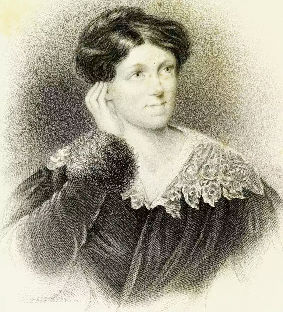
Harriet Martineau, in an 1833 portrait. Three years later, she left a moving description of the Illinois prairie outside Joliet.
The fascinating English author, abolitionist, and sociologist Harriet Martineau, visited northern Illinois in 1836, and left a vivid record of the beauty of the Illinois prairie she saw near Joliet. She told of the beauty of the American primroses and the “…difficulty in distinguishing distances on the prairie. The feeling is quite bewildering. A man walking near looked like a Goliath a mile off.”
Her dinner one evening consisted of tea, bread, potatoes, and wild strawberries, of which a whole pail-full had been gathered around the house in which she was staying in only an hour’s time. She remarked about the beauty of the blue spiderwort in full bloom, and of prairies being “perfectly level—a treeless expanse with groves like islands in the distance, and a line of wood on the verge.”
As the seasons progressed, the grasses and broad-leafed plants comprising the prairie ecology dried, providing plenty of fuel for autumn and spring prairie fires. In October 1835, Methodist circuit rider Alfred Brunsen wrote of northern Illinois prairie fires, noting that he had traveled by prairie fire light at night: “By the light of this fire we could read fine print for ½ a mile or more. And the light reflected from the cloud of smoke enlightened our road for miles after the blaze of the fire was out of sight.”
George M. Hollenback portrait from the 1914 history of Kendall County.
George Hollenback, one of the first two white children born in Kendall County (his twin sister Amelia was the other), left a description of prairie fires he recalled from his childhood. His memory of them was both exciting and alarming. He recalled seeing, as a child, as many as 50 fires burning at one time within sight of the Hollenback homestead near modern Newark in southern Kendall County, reflecting their light in the clouds on autumn evenings.
“Early settlers protected themselves by ploughing [sic] wide and numerous furrows around their fields and their stockyards,” wrote Hollenback.
Backfires were often started to protect houses and property as well as plowing furrows to create firebreaks. The band of blackened prairie grass burned in the backfire usually stopped the on-rushing prairie fire dead in its tracks.
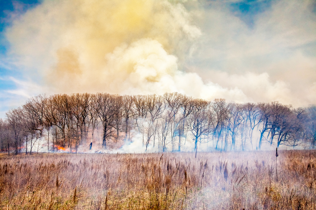
Prairie fires like this controlled burn at the Nature Conservancy’s Nachusa Grasslands near Franklin Grove cleared out understory shrubs creating the open savanna-type groves the settlers found when they arrived. The fires were both set by natural causes–lightning strikes–or intentionally set by the area’s Native People to modify their environment.
Prairie fires were usually pushed along by the prevailing winds on the Illinois prairies. That meant prairie fires most often came out of the west, and traveled eastward on the front of westerly winds. Old maps of Kendall County show that the timber on the western edge of the Fox River and the creeks in the county was much less dense that on the eastern edge, the trees on the west side thinned by the annual fires driven by those westerlies. There were generally fewer species of trees on those fire-prone western edges, too, with white and burr oaks and other more fire-resistent kinds predominating. (For a more in-depth discussion of the impact prairie fires had in Illinois, click here.)
A number of early Kendall County settlers left accounts of what Kendall County looked like when they arrived, just before settlement changed the prairies forever by converting them into farmland. Mary Elizabeth Jeneson, a member of Oswego’s Nineteenth Century Club, read a paper to the club in 1906, in which she stated: “No words of mine can convey to you the vastness, the grandeur and beauty of the natural prairie in 1850 when I first came to Oswego. The music of the big frogs down in the slough and the drumming of prairie chickens must have been heard to be appreciated. The Fox River was pretty then. Its banks furnished attractions for those who liked a stroll—a sort of Lovers’ Lane, in fact.”
Avery Beebe portrait from the 1914 history of Kendall County.
In 1914, Avery N. Beebe, an early Kendall County resident and elected official, offered his recollections of of how the area appeared to county pioneers: “This little chosen spot of God’s heritage, selected by the sturdy old pioneers of Kendall County, has been richly blessed with all the advantages that kind nature ever bestows: with its clear silvery streams, the Blackberry, the Big Rock, the Little Rock, the Aux Sable, the Waubonsia, the Rob Roy, the Clark, the Hollenback, and the Morgan, that pour their pure crystal liquids into the placid Fox and Illinois Rivers. All of these were densely skirted with abundant timbers for the use of the early settlers to construct the primitive log cabin, supply it with fuel, and establish the forest home in the wilds of the West; as it was then called.”
Change has been ongoing in northern Illinois in general and Kendall County in particular since the first pioneer wagons pulled up along the banks of the Fox River in 1828. During the last 50 years, that change accelerated as the county’s farmland—which itself replaced the stunning prairies described by the pioneers—has disappeared in job lots, with housing developments and shopping centers crowding out more and more open land. But on the positive side of the ledger, organized, serious efforts to preserve the region’s prairie past and the region’s remaining natural areas are continuing to grow.
The fascinating thing about volunteering down at Oswego’s Little White School Museum is you just never know what interesting bit of local history will walk through the door to brighten your day. And if your family has been lurking around these parts as long as mine has, sometimes those bits have a family connection, too.
A few weeks ago, one of those bits arrived when the son of a childhood friend of mine and his wife poked their heads in my office and said they had something that might interest me. And it did, both historically and personally.
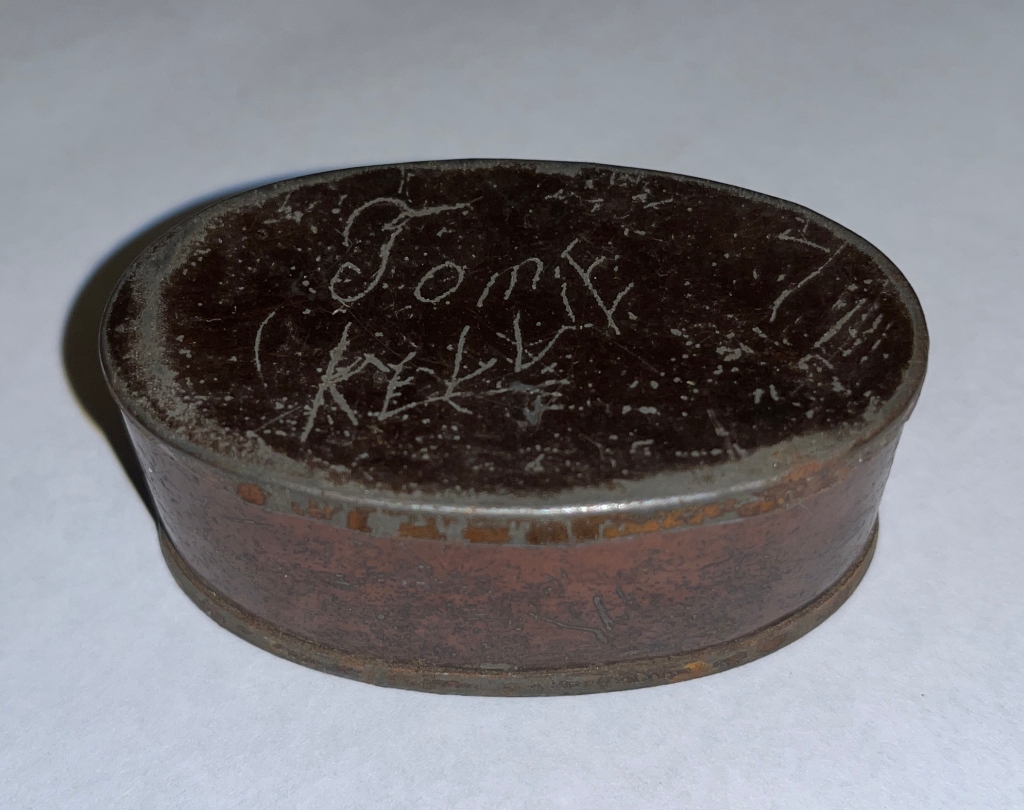
Tom Kelly’s snuffbox, now in the collections of Oswego’s Little White School Museum. Tom and his brother, John, were reportedly orphaned by the Great Chicago Fire in 1871, and were then raised by John Peter and Amelia (Minnich) Lantz.
The hinge was missing from the lid on the small, oval-shaped copper-colored tinned box—quite obviously a snuffbox—he showed me, but otherwise it was in pretty good condition. Smiling, he suggested I look closely at what was scratched in the metal box lid, and after turning it to catch the light I could make out “Tom Kelly.”
He’d found it while cleaning out his great-grandparents’ attic, did a little internet research on Tom Kelly, which pointed him to my interest in Tom and his twin brother, John. How the snuffbox got to the attic of Jim and Elizabeth “Bess” McMicken is a complete mystery.
Back in July of 2012, about five months after I started this blog, I published a post about twin boys, orphaned by the Great Chicago Fire of 1871, that my great-grandparents raised.
John Peter Lantz and Amelia Minnich on their wedding day, Feb. 16, 1869.
The story has a couple parts.
First, the twins’ story as recounted via family oral history. My great-grandparents, John Peter and Amelia (Minnich) Lantz, were married in 1869 out east of Oswego in Will County’s Wheatland Township and began farming out on the rich prairie on the family home place. In March 1871, their first child, a boy they named Isaac, was born.
Back in that day, farming was physically demanding for both the farmer and his wife, who had to work in a true partnership to make a go of the operation. Those farm wives, especially, had a difficult life. Common household tasks we take for granted these days, such as washing clothes, were complicated and labor-intensive back then. As a result, most farm couples who lived on large acerages like my great-grandparents had not only hired men to help with farming but also hired girls to help in the house.
But my Pennsylvania Dutch ancestors on my mother’s side were a thrifty lot—cheap, according to my dad—and they were grimly determined to spend as little money as possible on just about everything. But with a new baby to take care of along with all her other regular chores, my great-grandmother began demanding help of some kind.
Along about 1872, my great-grandfather, prodded into eventual action by his increasingly adamant wife, headed off to Chicago. The Great Chicago Fire had swept through the city in the fall of the year their son was born, killing some 300 people and creating a number of new orphans who joined the growing number of parentless children in the city. My great-grandmother, hearing about the availability of orphans, sent her husband into Chicago with orders to bring back an orphan girl to help around the house.
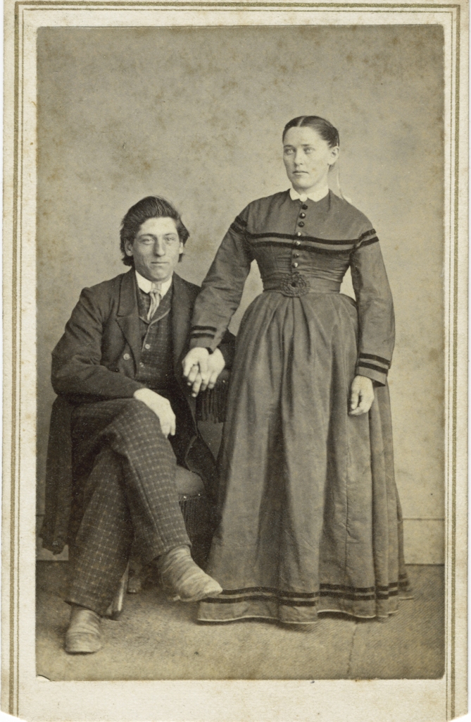
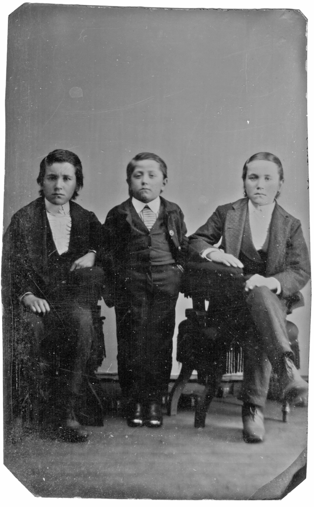
Left to right, Tom Kelly, my great-uncle Isaac Lafayette Lantz, and John Kelly. Tintype in Amelia Minnich Lantz’s photo album.
My great-grandfather was a soft touch and a bit of a dreamer, the kind of guy who dabbled in gold mining stocks bought from ads in the back of magazines and newspapers with hopes of getting rich—hopes that were invariably dashed. So it shouldn’t have been a surprise that instead of coming home with an orphan girl to help his wife around the house, he ended up bring home two six year-old orphan boys, Tom and John Kelly.
Whether they were even actually orphaned by the great fire isn’t part of family lore but they were welcomed as part of the family, although I imagine somewhat grudgingly on my great-grandmother’s part.
The Kelly boys not only lived with my great grandparents, but by all accounts were treated like their own children. In fact, in the 1880 U.S. Census of Wheatland Township, Will County, they are both listed as my great-grandparents’ sons.
During that era, farm children were expected to work hard, both helping on their own family farms and also by being hired out to other families. Their daughter, my grandmother, for instance, was hired out to nearby families when she reached the age of 14. She had graduated eighth grade with good marks and had looked forward to attending high school—and even found a well-off Aurora family willing to offer her board and room in return for help around the house while she went to school, but my great-grandparents refused the offer and insisted she work for wages. Women, their feeling was, didn’t need an education.
The Kelly Twins standing in back and John Peter and Amelia Lantz pose for a photo at the Kindig studio in Naperville. I suspect this photo was taken on the twins’ 20th birthday when they were each gifted with $1,200 and a new suit by the Lantzes.
So the Kelly boys, too, were hired out in their teens. The Sept. 20, 1883 Kendall County Record reported from Oswego that “Dr. Putt has gone to Nebraska; also John and Tom Kelly.” At that time they were 17 years old.
When they reached the age of 20, my great-grandparents gave each of them a new suit of clothes and $1,200—that’s nearly $40,000 in today’s inflation-adjusted dollars—in order to make their ways in the world. They apparently used the money to buy a farm out near Hastings in the southeastern corner of Nebraska where they’d gone with Dr. William T. Putt back in 1883.
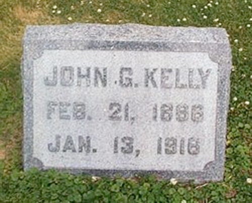
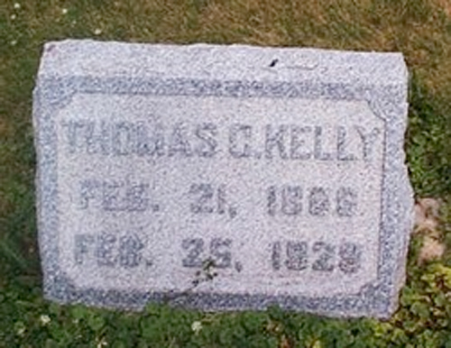
John Kelly’s tombstone in the Scotch Church Cemetery. (Jim Seidelman photo)
Eventually, however, they came back to Illinois and worked on various farms around the Oswego and Wheatland Township areas, John dying in 1916 and Tom living until 1929. They’re both buried in the Wheatland United Presbyterian “Scotch” Church Cemetery out in Wheatland Township.
Tom Kelly’s Scotch Church Cemetery tombstone. (Jim Seidelman photo)
I’ve heard about the twins my entire life, as part of our family’s lore. Photos of the boys came down to me through my grandmother’s family, a couple tintypes and some cabinet photos. And their burial records are part of the collections at the Little White School Museum. But Tom Kelly’s snuffbox is the first tangible item I’ve ever seen that one of them actually owned and used.
Down at the museum, you just never know what interesting bit of local history will walk through the door to brighten your day.
I admit I’m often a bit slow on uptake so I didn’t really occur to me until a couple weeks ago that this year will mark the 30th anniversary of the start of efforts to catalog and safely and properly store the mass of artifacts, photographs and negatives, and archival documents we’d collected at what had become Oswego’s Little White School Museum.
So after the thought occurred, it also occurred to me it might be valuable for others to learn the story of how today’s museum collections came to be created and managed. Before the colors fade, here’s a brief rundown of what took place all those years ago that resulted in the museum the community has today.
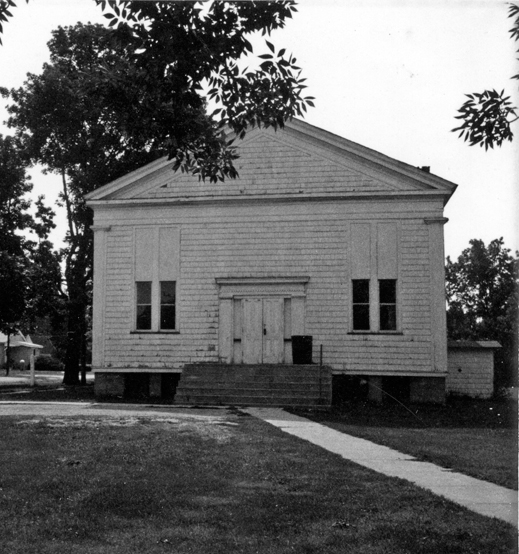
Photo of Little White School taken by Daryl Gaar in July 1970 in preparation for a real estate appraisal report for the Oswego School District. It looked even worse by the time restoration work began in 1977. (Little White School Museum collection)
The project to save the historic building and create a local history museum in it had begun in 1976 when a grassroots group of local residents established the Oswegoland Heritage Association (OHA) to oversee the project and raise funds to finance it. In a way, it was sort of reminiscent of one of those old Mickey Rooney–Judy Garland movies where they say “Let’s put on a show!” to raise money for some project or another. But this project turned out to be a lot more complicated, with many more moving parts, than one of those old movies let on.
The first thing that had to be done was to stabilize the badly deteriorated building, which required deciding what kind of project we were going to do, restoration or renovation. The OHA Board decided to restore the exterior of the main structure, built in 1850, to its looks in the earliest image we had of it, which dated to 1901. At the same time, it was also decided to renovate the badly deteriorated Jackson Street entrance hall and classroom addition, which had been added in 1936, to accommodate visitors and create a community museum room.
After exterior restoration was completed, the Little White School Museum became a valued community landmark. (Little White School Museum photo by Stephanie Just)
So, right off the bat, the OHA was working on a two-track project.
Also, as soon as the community learned the building was undergoing restoration and renovation, they began dropping off Oswego-related historical artifacts, photos and negatives, and documents. With two complicated projects already underway, those items were simply warehoused in the building’s basement to await figuring out what to do with them sometime in the future.
As it turned out, the exterior restoration and the renovation of the entrance hall and the museum room were completed by Oswego’s sesquicentennial celebration in 1983, thanks to local contractor Stan Young. He’d attended the Little White School as a youngster and figured out ways to achieve everything from restoring the building’s wooden front porch to recreating its missing bell tower.
The museum room—soon to be renamed the museum gallery—was filled with Oswego history exhibits created by OHA Board members and volunteers. It opened to the public in April of 1983.
In the meantime, the OHA Board was discussing what ought to be done with the building’s main room, renovate the two existing classrooms, front entrance vestibule and basement stairways, or remove the drop ceiling and interior walls and stairwells that had been added since 1930 and return the room to its original open 36×50 foot appearance during its original use as a Methodist-Episcopal Church and, starting in 1915, as a one-room school for grades 1-3. After much discussion, the board decided on the restoration option for the main room, taking its look back to the era of transition, 1913-1915, when its use changed from church to school. My friend from high school, Glenn Young, was persuaded to oversee the project, something he’d be closely involved with for the next 19 years.
Restoration work, consisting of removing all the interior walls and the drop ceiling began in the fall of 1983. Fortunately for us, Caterpillar, Inc. was undergoing one of its periodic strikes and my high school classmate Jim Williams, and cousin-by-marriage Omer Horton were both free to volunteer partial days on the project, getting it done much faster than we’d expected. It was about that time the park district retained Oswegoan Mark Campbell and Don Drum to help with the project every Saturday.
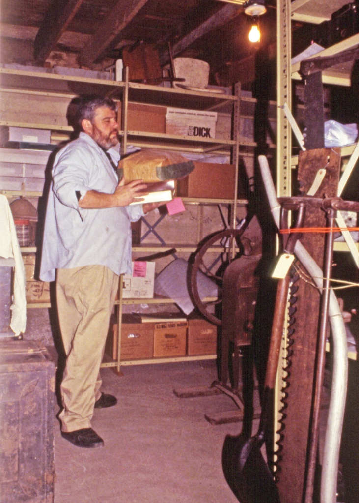
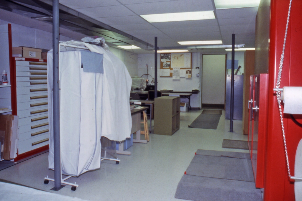
In 1994, the basement of the Little White School Museum was an unorganized jumble of items–including priceless artifacts and documents–that had been dropped off during the previous nearly two decades. The first task was to create some sort of order out of the existing chaos. (Little White School Museum collection)
But by the fall of 1993, a decade later, the interior restoration project was far enough along that the board decided to finally get serious about organizing, cataloging, and properly storing all those historical photos, documents, and artifacts that continued to arrive. But, again, it proved more easily said than done.
Keith Coryell works on shelving 3-dimensional artifacts in 1995 following the initial macrosort of the Little White School Museum’s collections. (Little White School Museum collections)
The basement storage area was an unorganized jumble of priceless items that were in danger of damage, and there was no museum office where files could be created and kept. So, the first item of business was to clean out a corner of the basement to create suitable office space. That required coordination with the restoration project as the two efforts were going on at the same time. It took a while, too, because volunteers only worked Saturday mornings and park district-financed construction people only worked Saturdays as well.
A bit earlier in time one of the old farmhouses on Douglas Road in Oswego was being demolished to make way for new development. We were given permission to salvage the kitchen cabinets and doors and doorframes from the building, which were used in the new office. Some used countertops were also located that fit the cabinets just fine. A couple used file cabinets and desks finished out the furnishings.
Stephenie “Stevie” Todd works on the macrosort of the Little White School Museum’s collections in late 1994. (Little White School Museum collection)
Also about the time we were ready to start the organizing and cataloging project, we were lucky enough to gain the services Stephanie “Stevie” Todd, of one of the best historical researchers in the Fox Valley. She was able to procure the volunteer services of Keith Coryell, an actual museum professional who was (fortunately for us) between jobs at the time and willing to help us get started with our project.
We figured early on it was vitally important to get off to a good start. We’d heard horror stories of museums where they’d had to change their systems of cataloging items for one reason or another, sometimes losing track of huge portions of their collections. Because the most important trick with museums isn’t cataloging and properly storing items, it’s the ability to find them again once they’re placed in their forever storage home.
Also, we had to decide exactly what our collection was supposed to represent. Those of us who like old things have an urge to save everything, but we knew we had limited storage space, and so had to decide what our paramaters were. The OHA Board decided the items we collected were to directly deal with the 68 square miles inside the Oswego School District, including the families, businesses, farms, towns, and other things that included.
Cabinets removed from a farmhouse undergoing demolition and some used countertops furnished the new museum office. (Little White School Museum collection)
The “what” settled, the questions related to “how” were next to solve.
We had decided years ago to use a trinomial artifact numbering system, with the first number being the year the item was donated, the second number denoting the order it was received during the year it was donated, and the third number affixed to individual items in multi-item collections.
That was fine and fit in with they way many museums numbered their items. The next decision was whether to number all classes of items—documents, photos, and artifacts—the same. At that time, many museum had different numbering schemes for each type of item, which didn’t seem sensible to us. We figured if someone was going to come to the museum looking for, say, items dealing with the Shoger or Burkhart families, they’d want to see a listing of every item, no matter what kind it was, related to the family or other topic they were searching for. We also though our system would be of benefit for our own staff when, say, looking for items to create exhibits. If we were doing an exhibit on Church School or Bohn’s Grocery Store, we’d want to turn up whatever photos, documents, and artifacts in the collection.
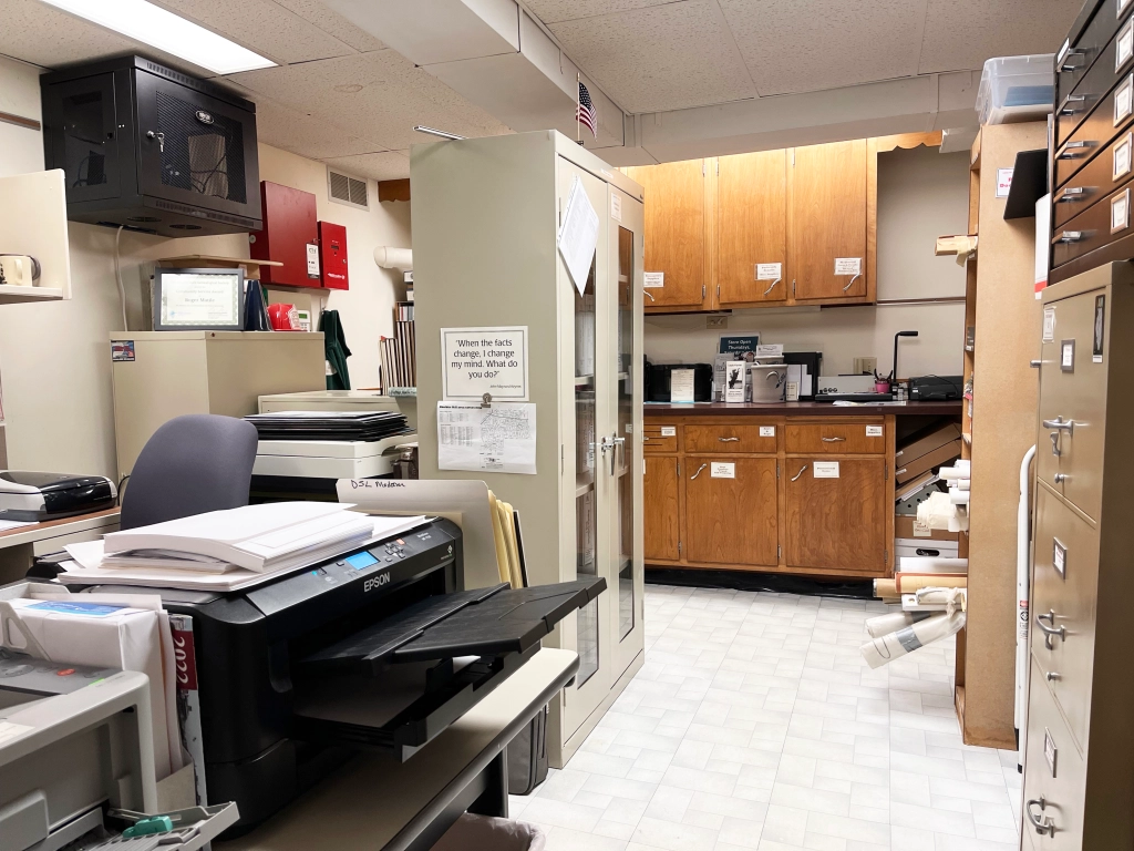
The museum office this past autumn, filled with file cabinets, a new computer server (on the wall) our large format printer in foreground–and still featuring the used cabinets installed 30 years ago. (Little White School Museum collection)
And to keep track of all those items we were looking at we knew from the beginning we were going to need some sort of computerized database system. We’d dabbled with creating card files of artifacts at random periods earlier on, but couldn’t really make them work.
There were commercially available museum cataloging systems available, but at that early time, many of them insisted in treating photos, artifacts, and documents differently, which we didn’t want to do. Further, there were no Macintosh-based cataloging applications available. We’d decided to use Macs because we also wanted to create our own graphics—signs, labels, document and photo scans—and newsletters, and Macs were the gold standard for doing those things.
So, we ended up creating our own cataloging database using the Mac-compatible FileMaker Pro application. We wrote to more than a dozen area museums requesting copies of their accession sheets—accessioning is the formal, legal process of taking ownership of items donated to a museum or library—so we could figure out which fields we wanted to make sure we had in our own database.
The basement archives work and research area with the Equipto flat files to the left and the mobile unit to the right in a photo taken a few years ago. (Little White School Museum collection)
In the early spring of 1994, I’d taken a course out at Waubonsee Community College on museum planning that Keith Coryell had given. And in that course, he strongly recommended that a museum needs a director to oversee the technical aspects of cataloging and storage of donated items. I took that lesson and the data backing it up back to the board and in August 1994 they appointed me museum director with the task of coordinating and overseeing the Little White School Museum’s collections management.
Because the main volunteer emphasis was still on the main room restoration project, we solicited other volunteers to help clean up the basement area, get the floor and walls painted, and staple Tyvek fabric to the ceiling to stop 140 years worth of dust accumulated in the floorboards from sifting down into the basement and onto the artifacts and other materials being stored there. Fortunately, within a couple years, the park district agreed to finance installation of a new drop ceiling (we were able to find a bunch of used light fixtures for the project) that eliminated the sifting dust problem and brightened up the area considerably.
The old textile shelving with non-acid free boxes served well until we could find a better solution. (Little White School Museum collection)
By the autumn of 1994, we were finally ready to begin seriously addressing the collection. Stevie, Keith, and I began showing up at the museum on Thursdays to work on the collection, beginning with a “macro sort,” which left me free to help with the main room restoration project on Saturday mornings. Keith explained the macro sort consisted, basically, of putting like items in piles—textiles, documents, 3-dimensional artifacts, and photogrsphs and negatives.
We also assembled used shelving we’d acquired in the building’s old basement coal room, which we’d painted as a spot where we could temporarily store our sorted piles.
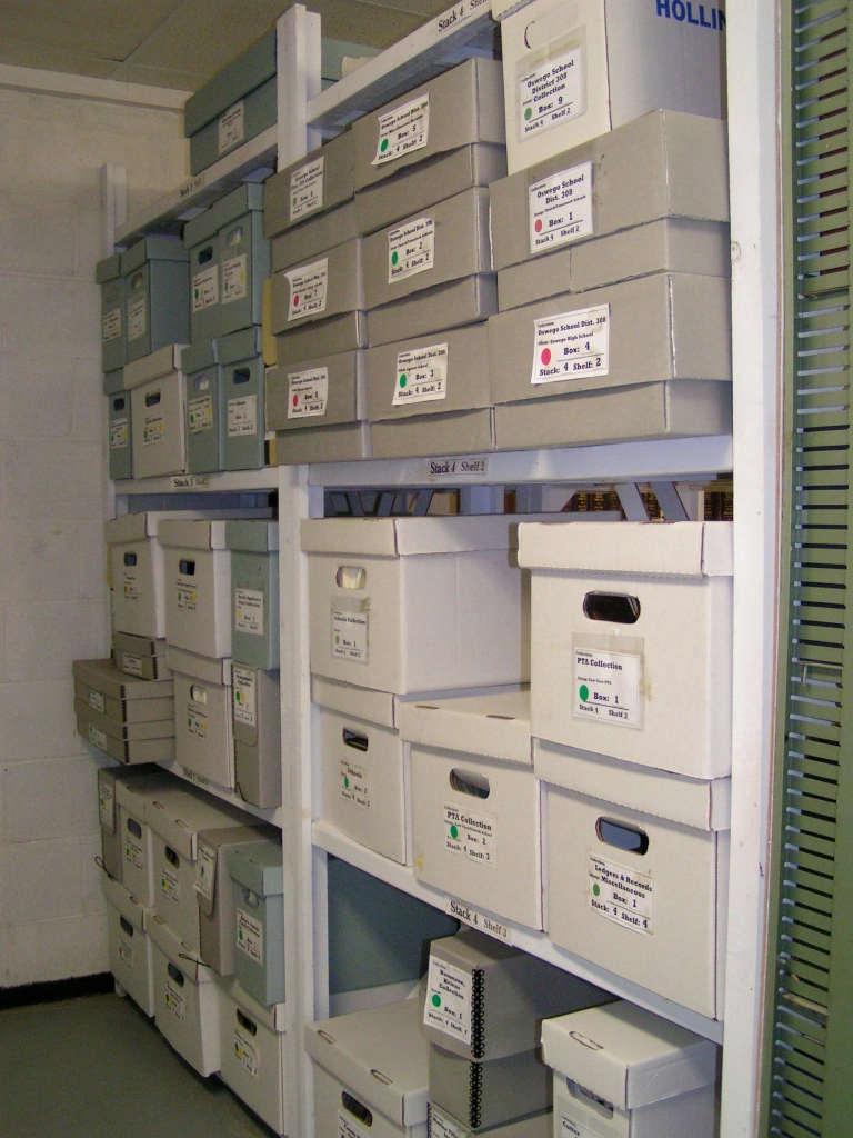
One of the two racks of textile shelving loaded with acid free textile boxes that now store the museum’s collection of everything from military uniforms to wedding dresses. (Little White School Museum collection)
Keith explained the need for acid-free storage media—folders, envelopes, and boxes—as well as acid-free paper with which to make photo copies and so off went our first orders to Hollinger, Inc. and Gaylord, Inc. for the necessary materials. Full-sized and half-sixed record storage boxes from Hollinger, it turned out, were the museum industry standard, and no matter from which manufacturer they were acquired, they were called Hollinger boxes. We were going to need a LOT of both sizes of Hollinger boxes.
The seemingly little things we decided then have stood us in good stead. For instance, when we were planning our needs, we decided that all our file cabinets should be legal and not letter sized. That’s because legal documents are, naturally, legal sized. Documents, Keith, explained, need to be stored flat and unfolded. And while letter sized documents fit in legal sized folders, they don’t fit in letter sized folders.
Another important decision we made was to store our photos—including postcards—in correct archivally-safe pocket pages in three-ring binders. We decided that would allow easy and safe access to the photos, which, 30 years later, it certainly has.
But what about over-sized documents and photos that wouldn’t fit, unfolded and flat, into legal file folders? For that, we needed flat files. And like the helpful Caterpillar strike back in ’83, fate stepped in once again. The venerable Equipto manufacturing company in Aurora was closing its plant, including its showroom. Mark Campbell used his connections to broker a donation from Equipto of a large set of flat files and a unit of rolling shelving that had been on display in their show room. Mark was also able to figure out how to get the storage equipment moved to Oswego and into the museum’s basement storage area. Oversized documents and photos required oversized folders for storage, and fortunately we found all kinds of those in the Gaylord, Inc. catalog.
By 2007 when this photo was snapped in the museum’s archives storage room, the shelves Glenn Young custom made to fit Hollinger records storage boxes was already rapidly filling up. (Oswegoland Heritage Association collection)
Remember all those Hollinger boxes we had on order? We needed someplace to safely and efficiently store them, so we checked with Glenn Young. He agreed to take time out from the main room restoration project to build custom wooden shelving perfectly sized so each shelf would hold six full size Hollinger boxes. We also got the donation of some surplus bookshelves from the Oswego Public Library.
We’d decided to make the basement’s old furnace room, which had been separately walled off sometime in the 1950s, our archival storage area. Its walls were all concrete blocks and it had a fire-proof steel security door, making it the most secure room in the whole building. After we put a couple coats of acid-free paint on the wooden shelving Glenn had made, he installed them and the four steel bookshelves in the archives storage room.
So as 1994 turned into 1995 while sorting and storing the results of the macro sort continued, we were finally ready to start formally accessioning and cataloging all those items that had arrived during previous quarter century. The first really new item was added to our new database on Feb. 14, 1995 while we started work on the backlog, including Dick Young’s extensive collection of Native American stone projectile points and tools collected in the Oswego area.
If the dates donated items had arrived were still with them along with the donors’ names and (hopefully) addresses, we used those to formally accession the items. If we didn’t know when and who donated an item, it was given an “X” instead of a date leading number, denoting “Found in Collections.”
As it turned out, Dick’s collection was the first one we had complete provenance on–a fancy word meaning we definitely knew where and when it came from—and so it got the first verifiable number, 1983-1, with the first point, numbered 1983-1-1, a Snyder projectile point dated to 500 BCE.
And from there over the years, a changing, but always dedicated core of volunteers, and lately paid part-time park district staff, have kept at cataloging and adding capabilities to the collection and to the process of managing it. Keith Coryell got a permanent job, Stevie Todd moved on to other projects, and Bob Stekl and Stephanie Just came aboard for a few decades. The OHA bought a large format scanner, updated its computer equipment, bought a used large format copier, and began a collection of microfilmed documents. The park district bought a used microfilm reader/copier.
Volunteer Bob Stekl works cataloging a collection of small items at the Little White School Museum in 2014. (Little White School Museum collection)
We’d bought a bale of non-archival cardboard boxes to store textiles in during the macro sort, planning to eventually transfer over to acid-free boxes. two successive matching grants from the Illinois Association of Museum’s helped fund two new shelving racks and sufficient archival quality boxes to fill them.
We kept adding shelving and storage cabinets wherever we could find a bit of space in our basement storage area, always managing to keep a bit ahead of the steady stream of new materials that always kept arriving while also slowly but surely whittling down that huge backlog that had built up. Museum Collections Assistant Noah Beckman, one of the part-time staffers provided by the park district, finally finished up the last of the initial backlog a year or so ago, completing cataloging a collection of items donated by Evelyn Heap several years before he was born! Without the OHA’s continued partnership with the Oswegoland Park District, in fact, the museum simply would not exist.
From that initial item entered into the database 29 years ago, the museum’s collection has now grown to more than 37,000 entries ranging from prehistoric stone tools made by the area’s Indigenous residents to modern high school yearbooks to photographs and documents that chronicle the Oswego community’s history from the pioneer era to the present day.
The collection continues to grow at about 1,000 items per year, each item having some direct connection to the 68 square mile area inside the bounds of the Oswego School District, saved so future generations will be able to appreciate and learn about the community’s rich history and heritage.
On Sunday, March 10, starting at noon in the museum’s restored main room, I’ll present a history of the Little White School Museum, including the building itself, the restoration project, and its current uses, and members of the heritage association board will give tours showing off some of the latest upgrades, including a new accessibility ramp and a remodeled main entrance hallway. You’re all invited. Admission is $5 for park district residents and $10 for non-residents, money that will go towards helping us protect and preserve all that irreplaceable history we’ve collected since 1976.
Several years ago while doing family history research, I made connections with a distant cousin who sent me a compact disc (remember those?) with dozens of photos and documents related to my Minnich ancestors. Among the documents were letters written by my great-great-grandmother, Mary Ann Wolf “Polly” Minnich, to her daughter, who was then living out in Kansas.
Mary Ann Wolf “Polly” Minnich from what was probably her 1846 wedding portrait.
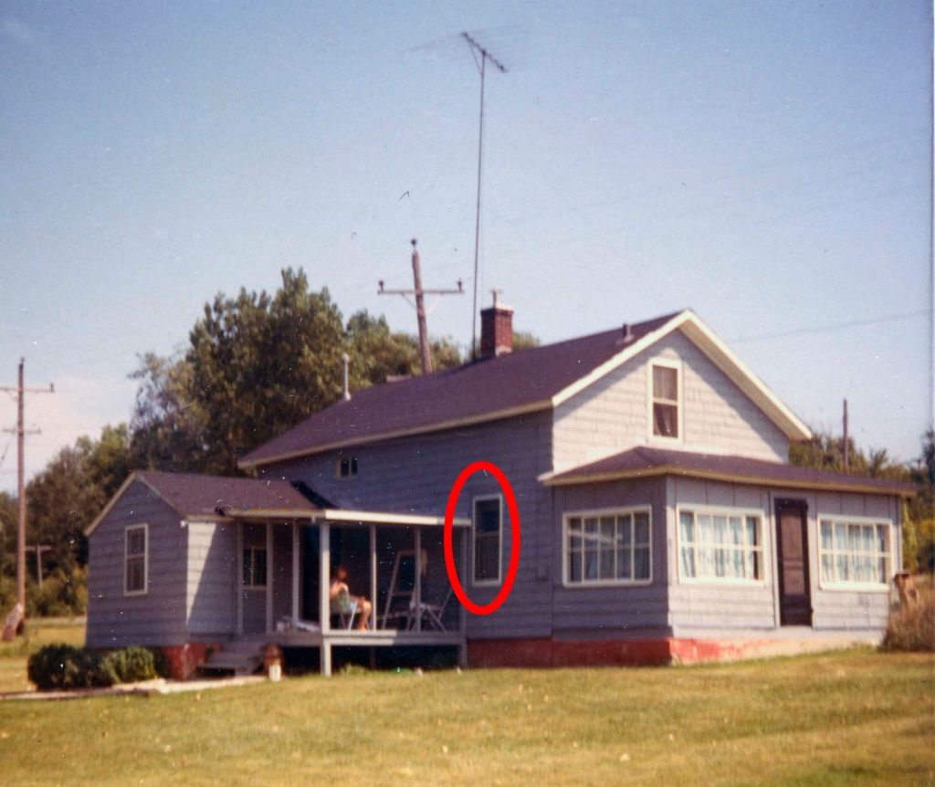
The letters were remarkable for a few reasons, not the least of which was because Mary Ann was illiterate. According to the letters’ content, she dictated them to one of her grandchildren, who wrote and mailed them for her and who would then also read the replies to her. Another interesting point, for me, at least, was that at the time she was corresponding with her daughter, she was living in the ramshackle old house on North Adams Street in Oswego that was the first house my wife and I bought back in 1968.
The previous owners were the first non-family members to have owned it since my great-great grandparents owned it in the 1870s. We lived there for about 10 years, and so I was familiar with its interior layout. My grandmother, who as a child had visited HER grandmother at the house told us about the interior changes that had been made, including turning my great-great grandparents’ tiny first-floor bedroom into the home’s bathroom. Which is why the bathroom had a full-sized window in it above the bathtub that looked out onto North Adams Street and the east bank of the Fox River across the road.
The Minnich House as it looked in 1970 with Mary Ann’s bedroom window facing North Adams Street and the Fox River circled in red.
By the time we moved in back in ’68, trees lined both banks of the river, cutting off the view of Route 31 over on the river’s west side. But back when my great-great-grandparents lived there, the original old-growth trees on both banks had been cut down years before to provide everything from fence rails to firewood to building materials for homes and other buildings the pioneers needed. So someone looking out of the window in our bathroom—formerly my great-great-grandparents’ tiny bedroom—could easily have seen traffic over on Route 31, known back in the late 19th and early 20th centuries as the West River Road.
Which is a long, but I think necessary set-up for a fascinating comment I found in one of those letters long ago transcribed from my great-great-grandmother’s dictation.
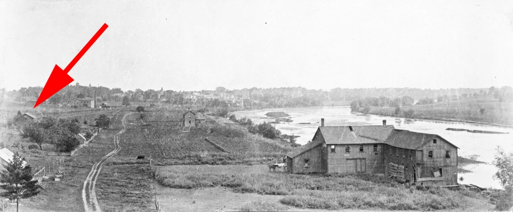
North Adams Street about 1910 with the arrow pointing out my great-great-grandparents’ house, and illustrating the treeless banks of the Fox River during that era. The building at right foreground is the Parker Sawmill and Furniture Factory. (Photo by Irvin Haines in the collections of the Little White School Museum)
By late September 1900 residents living in and around Oswego, including those living along North Adams Street, had some new sights to see and marvel at. As my great-great-grandmother put it in one of those letters to her daughter out in Kansas: “When I can’t sleep at night I can watch the Street cars run out my window over across the river.”
She could see the headlights of streetcars running on the west bank of the Fox River in 1900? Yes, as it turns out, there was, indeed, a trolley car line that ran from Aurora south roughly following the Fox River to Oswego that began service that year.
This contemporary map illustrates the route of the interurban trolley line from downtown Aurora south through Oswego into downtown Yorkville where it terminated at Van Emmon and Bridge streets. (Little White School Museum collection)
Because this kind of trolley line ran between towns and not wholly inside them, the lines were called “interurban” trolleys, and were at the height of their popularity as the 20th Century dawned.
A group of investors first proposed building an interurban trolley line from Aurora south through Montgomery and Oswego to Yorkville in 1897. The proposed line was planned to run mostly on public street and highway rights-of-way using light rails and electrically-powered trolley cars.
First iron bridge across the Fox River at Oswego. A King’s Patent tied-arch (also called a bowstring arch) truss iron bridge, it was built by Oswego Township in the fall of 1867 at a cost of $17,000. The bridge was manufactured by the King Iron Bridge & Manufacturing Company of Cleveland, Ohio. It was replaced in 1900 to carry the tracks of the Elgin, Aurora & Yorkville interurban tracks across the river. (Little White School Museum collection)
An early proposal to build a third-rail electric line was quickly discarded in favor of using overhead electrical lines with the cars picking up the power using car-top trolleys. Cars running on third-rail lines picked up their electrical power from an exposed electrified third rail, something that would obviously be dangerous on a rail line running through towns and the countryside and not in an underground tunnel or on an elevated track safely out of reach of pedestrians, horse-drawn vehicles, and livestock.
In August 1897 representatives of the new Aurora, Yorkville & Morris Electric Railroad company (the line’s name would change several times during the next few years) met with the Kendall County Board to start hammering out a trolley franchise agreement. As proposed, the line would begin in downtown Aurora, then run south on River Street through Montgomery, paralleling the Fox River past the new Riverview amusement park (which was to have its own station) then under construction just south of Montgomery before gently curving west to join the West River Road—now, as noted above, Ill. Route 31—for the run to the Oswego Bridge across the Fox River. There, the line would turn east, cross the river on Washington Street to Oswego’s Main Street, where it would turn south once more, following Main Street and heading towards Yorkville along what is now Ill. Route 71. Near Yorkville, the line would turn once again to follow the tracks of the Chicago, Burlington & Quincy’s Fox River Branch Line between the tracks and today’s Van Emmon Road right into downtown Yorkville, where the tracks dead-ended at Van Emmon and Bridge streets.
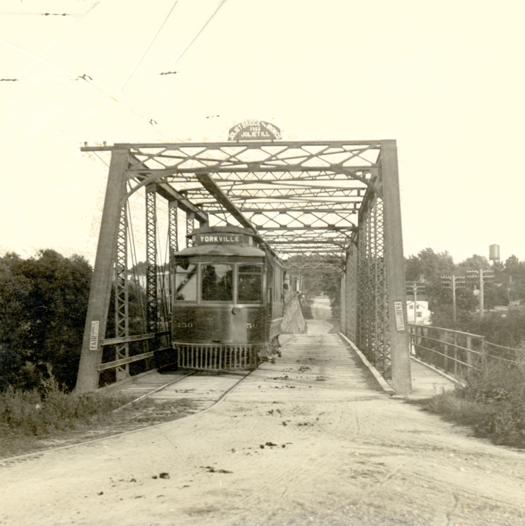
The box truss iron bridge built with trolley company assistance in 1900 to carry interurban cars across the Fox River at Oswego. It replaced the first iron bridge at Oswego built in 1867, and was itself replaced in 1937 to carry increasing motor traffic across the river. (Photo by Dwight Young in the collections of the Little White School Museum)
Among the issues that had to be hammered out was who would pay for improvements the line required, such as either strengthening or rebuilding the Oswego Bridge to carry the heavy trolley cars across the river. In addition, the company pledged “that in every way possible the company would guard against frightening horses” or otherwise interfering with traffic on the roads alongside and on which the trolleys would run. In the end, the trolley company agreed to pay $3,500 towards the cost of a new, stronger box truss iron bridge to replace the existing 1867 tied arch structure at Oswego. The other issues were ironed out as well, including how the trolley line would get across the Chicago, Burlington & Quincy’s Fox River Branch rail line in Oswego.
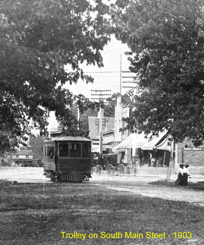
Interurban trolley car (center of the photo) approaches the west end of the Oswego Bridge about 1903 enroute from Aurora to Yorkville. The tracks crossed the Fox River on the Oswego bridge and then turned south along Main Street.
Residents of the towns the trolley would serve were, in general, enthusiastic about the new, all-weather transportation option. As Kendall County Record Publisher John R. Marshall noted in a Dec. 13, 1899 commentary: “With only four reliable trains a day, it was hard for one to come here and be so late getting into Chicago as is necessary with the regular passenger train. With the electric accommodations, one can go to Aurora and take an early morning train to Chicago.”
After crossing the Oswego Bridge, the interurban line climbed the Washington Street hill and crossed the CB&Q Railroad tracks on a 300-foot timber trestle. (Little White School Museum collection)
Construction began in the spring of 1900 and by June 27, the tracks were completed from Aurora to the west end of the Oswego Bridge.
“Operation of the electric road from the bridge will be commenced this Tuesday afternoon by a free ride of the town and village officials to Aurora and back,” the Record’s Oswego correspondent wrote in that week’s paper. “Yorkville will have to wait about three months longer before enjoying such privilege.”
This 1903 map shows the interurban route through Oswego. Look closely in the lower left at the siding at the Oswego Cemetery. Special funeral cars that carried mourners to this cemetery and farther south, to the Cowdrey Cemetery used this siding and the one at Cowdrey for funerals. (Little White School Museum collection)
Regular service began in early July from Aurora to the terminus at Oswego, and use proved enthusiastic—and frequent. As Marshall wrote on Aug. 1: “That the Aurora and Yorkville electric road will be a great convenience and daily comfort is shown by the way it is used now between Oswego and Aurora. Every day parties drive up from about here [Yorkville] to Oswego and take the car there for Aurora, saving 12 miles’ [round trip] drive.”
Work continued feverishly the rest of the summer and into the fall of 1900 on Oswego Township’s new Oswego Bridge. Construction was also ongoing on an impressive 300-foot trestle at the east end of the bridge designed to carry the electric line up Washington Street over the CB&Q tracks to the Main Street intersection.
By late December, the new bridge and trestle, along with the tracks into Yorkville were finished and regular trolley service had begun, linking downtown Aurora through Montgomery and Oswego with downtown Yorkville. The first car arrived at the Kendall County seat at 10:45 a.m. Saturday, Dec. 22, 1900.
“There were two cars down—one with the Aurora guests, the other empty to return with a number of the distinguished populace of Kendall’s capital,” the Record reported on Dec. 26. Welcoming the new arrivals was Record publisher Marshall, who had also welcomed the first railroad train on the Fox River Branch into Yorkville 30 years before.
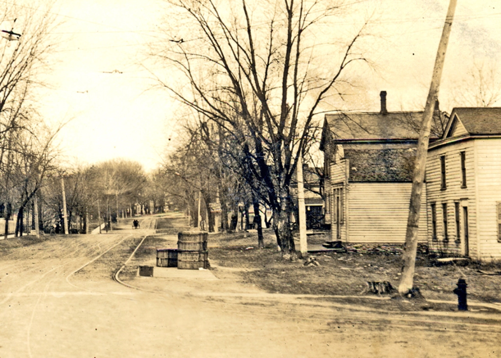
At Washington and Main streets, the trolley line turned south to follow Main out of town. This was also the village’s trolley stop, with a waiting room in the building at right just behind the fire hydrant. Note the stack of wooden bread crates. Fresh bread from Aurora bakeries was delivered early every morning. The Little White School Museum has two in its collection, including on on exhibit that was repurposed as the village’s ballot box. (Little White School Museum collection)
The interurban, providing hourly round trip service from Yorkville to Aurora from 7 a.m. until 11 p.m. at affordable rates, was part of a vast interurban network that, it was said, allowed passengers to travel via trolley from the Mississippi River, with transfers, all the way to New York City.
Note the two passengers who’ve just stepped off the interurban, likely after a shopping trip to downtown Aurora. (Little White School Museum collection)
In an era of terrible roads, the interurban was a godsend, carrying passengers and perishable freight, including farmers’ milk, to and from Aurora. Everything from fresh bakery bread to college and high school students to office workers to shoppers rode the trolley to and from Aurora daily. For instance, war hero, musician, and star athlete Slade Cutter rode the interurban to Aurora to attend East High School. The line ran right past the family farmhouse (which still stands at the corner of Ill. Route 17 and Orchard Road) during a time Oswego High School only offered a two-year program.
Motor vehicles shared in-town streets with the interurban lines, making driving on them often an adventure. Here, an auto rattles south on still unpaved Main Street about 1910 in Oswego while sharing the road with the trolley tracks. (Little White School Museum collection)
But a little more than a decade after the line opened, it and others throughout the nation were under financial assault from the burgeoning number of automobiles and trucks—and government support for them.
It wasn’t so much the improved vehicles that doomed the trolleys, but the rapidly improving roads they traveled on—and their funding. From the time Illinois was settled until 1913, road maintenance was the responsibility of township property owners. Each voter—meaning men during that era—was required to work on road maintenance or to pay money in lieu of work. But with the advent of affordable, dependable motor cars and trucks, the old system was proving unequal to the task of road maintenance and construction. So in 1913, the Illinois General Assembly passed the Tice Act, removing the work requirement and replacing it with a property tax levy to fund road construction and maintenance.
An interurban car at the terminal in downtown Yorkville. It’s been turned around on the trolley line’s wye track and is ready to head back north through Oswego and Montgomery to Aurora. Note the advertisement for the Kendall County Fair. (Little White School Museum collection)
At the same time, the public was also insisting on more and better roads, and in what proved a momentous policy decision, U.S. politicians decided that tax dollars should only fund construction and maintenance of roads and not the rails used by railroads and trolley companies. Although few realized it at the time, the policy meant the substantial government subsidy favoring road transport would gradually result in curtailing all of the nation’s rail systems.
Interurban trolley ticket for a passenger fare from Aurora to Oswego from 1918. Note the “War Tax” schedule in the upper left. The tax was levied by the Federal government to help pay for World War I. (Little White School Museum collection)
And with that profound change in motion, in 1918, in spite of the nation’s involvement in World War I, Illinois voters approved a $60 million bond issue to build a system of all-weather paved roads to connect with every county in the state, the bonded indebtedness to be paid through gasoline taxes. The measure passed overwhelmingly. Here in Kendall County, the vote was 1,532-90.
A new iron bridge crossed the Fox at Oswego in 1900 to carry interurban trolley cars across the river, along with regular road traffic. Above, a trolley car is captured on its way from Yorkville to Aurora. (Little White School Museum collections)
The interurbans were simply unable to compete with the combination of increasingly inexpensive, efficient, and dependable motor vehicles and publicly financed roads. Starting in the 1920s, one by one, the interurban lines closed down, went bankrupt, or both.
On Aug. 6, 1924, the Record reported that “Through an order from the Illinois Commerce Commission, the interurban line from the [Fox River] park south of Montgomery to Yorkville will be discontinued.” In the event, the line carried on until Feb. 1, 1925, finally succumbing to the advance of transportation technology and the national consensus to subsidize roads but not rails.
Today, there are scant reminders of the trolley era, but look closely between the road and the railroad tracks the next time you drive Van Emmon Road into Yorkville—especially this time of year with trees and shrubs leafless—and you will see some of the last evidence of the old trolley line that was once such an important part of the area’s transportation system.
Look at the buildings in Oswego’s small downtown business district, and they look so solid you get the impression they’ve always been there. Which, of course, they haven’t—everything was new at one time or another, even those familiar downtown storefronts.
Throughout the years, I’ve done quite a bit of research on individual aspects of Oswego. I’ve decided to get as much of it as possible down and available online to anyone interested. Because as we all know—or should know—the stuff you post online is forever.
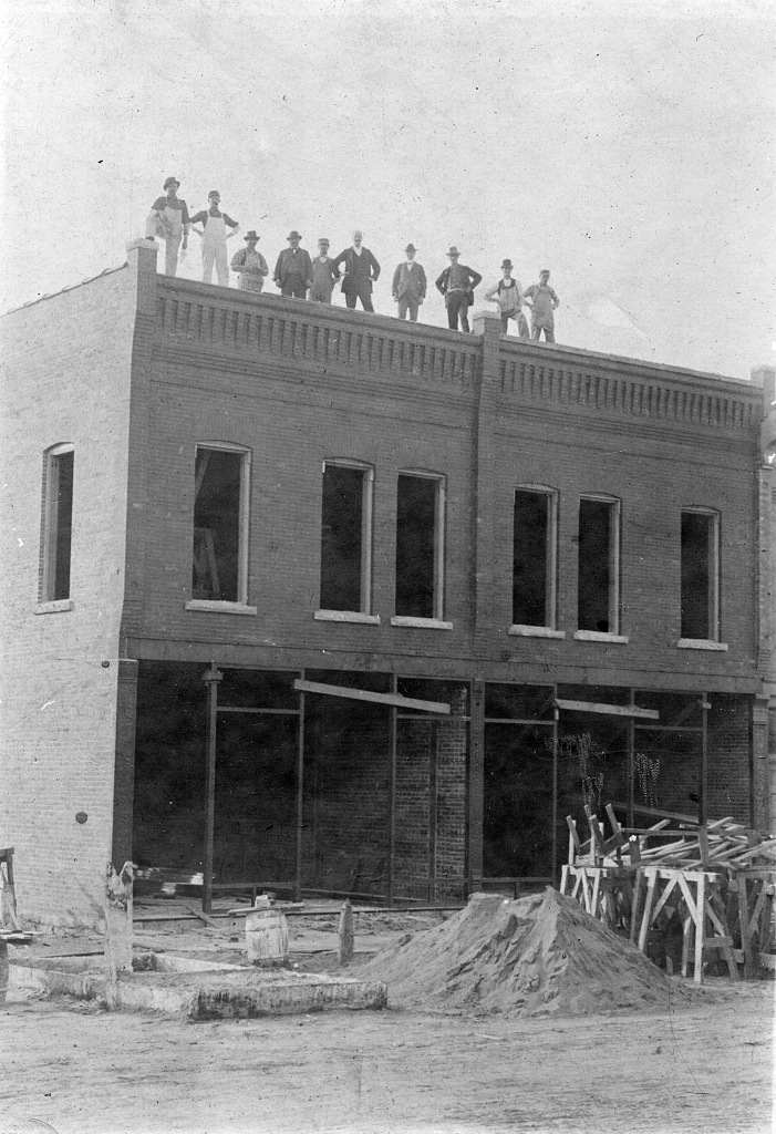
The Knapp Building (left) and the Oswego Saloon building were sporting their new white brick storefronts in 1958 when Oswego Photographer Homer Durand took this photo. (Little White School Museum collection)
I previously sketched the histories of the landmark Union Block and Rank Building on the east side of Main Street. This week, I figured I’d mosey across the street and look at the histories of the Oswego Saloon and adjoining Knapp Building. Today, the Knapp Building houses the Masonic Hall and the Oswego Family Restaurant, while the old Oswego Saloon is the location of the Happenstance Goods antique store.
“Oswego Saloon?” I imagine you’re wondering. And yes, a major downtown building originated as a saloon. And not just any saloon, either, but arguably the most elegant watering hole in town.
Saloons in the late 1800s were important to municipalities throughout northern Illinois because they generated license revenue. This was the era before municipalities were allowed to levy real estate or sales taxes. The only municipal revenue sources were fines for violating village ordinances generated by local justices of the peace—and the aforementioned saloon licenses, plus billiard table licenses.
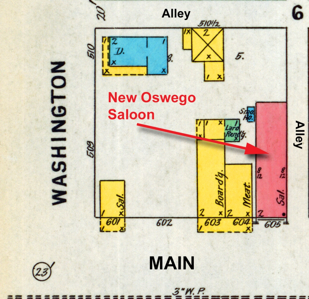
The Oswego Saloon location as depicted on the 1885 Sanborn Fire Insurance Company map of downtown Oswego. The yellow color denotes wooden frame buildings, while blue represents stone construction. (Library of Congress collection)
In fact, the revenue from Oswego’s saloons—there were at least two, often three in town—financed the village’s first municipal water system, including the elevated tank and water mains, along with the equipment for its first fire brigade and the first system of concrete sidewalks.
That municipal revenue was one reason prohibition of alcohol was such a hard sell. Saloon licenses were set at $1,000 per year in the late 1890s, which amounts to about $34,000 in 2024 currency, before being lowered to $750 in the late 1890s after some of those improvements had been paid off.
And please note, today’s Oswego Inn at Main and Jackson, formerly Johnson’s Tavern, did not exist until the first third of the 20th Century after Prohibition ended.
This image of the west side of Main Street looking north from Washington Street is reminiscent of photos of western cow towns. It was probably taken sometime in the 1870s when the building that would be replaced by the Oswego Saloon was a grocery store. (Little White School Museum collection)
Oswego’s 19th Century saloons were all located on the west side of Main Street between Washington and Jackson, in a stretch of frame and limestone storefronts that resembled, more than anything else, one of the cow towns out west of the Mississippi. By the 1890s, those buildings were showing their age, and both in-town and out-of-town business owners were thinking about replacing the old buildings with new, modern ones.
On Oct. 19, 1897, the Kendall County Record’s Oswego correspondent, Lorenzo Rank, reported: “The Schroeder saloon building is being demolished by Aurora parties to whom it belongs and a new one will be erected in the place of it.” The building fronted on Main Street and bordered the south side of the alley that ran east to west across Main Street between the Union Block and Rank’s Oswego Post Office on the east side of the street.
The new building was designed with elements of the old Italianate style, but it also included some more modern Eastlake design elements, creating an interesting transitional style all its own. It was the first major building project downtown since the Star Roller Skating Rink had been completed across the street from the new saloon back in 1885. The frame rink building was situated on the lot north of Rank’s Oswego Post Office building on the site of the old National Hotel that burned with everything else on that side of Main Street in February 1867.
The 1898 Sanborn map of downtown Oswego shows the new brick Oswego Saloon building—the pink color denotes it was of brick construction. (Library of Congress collection)
On Nov. 3, Rank reported construction on the new saloon was moving forward at a brisk pace. “The new brick building, which is to be built of the most modern style of architecture and finish, will be the pride of the town,” he wrote. “We folks who have been in the habit of saying that ‘saloons are no good’ will have to dry up. The building is about ready for the roof.”
Not everyone in town was impressed with the new saloon—or any saloons for that matter. In February as the building was nearing completion, Margaret Phillips Young, president of the Oswego unit of the Women’s Christian Temperance Union, caustically complimented the people of Oswego, noting that, among other things, they maintained four churches for salvation, and three saloons for damnation.
As completed, the building featured the modern saloon on the first floor and an apartment above.
On March 23, Rank noted the building’s interior decoration was nearly completed, and—although himself a teetotaler—was so overawed at the saloon’s beauty he was almost unable to express himself: “J.A. Schmidt and Ira Ackley have been doing the decorating of the new saloon building, all of which is most magnificent. Every room is of different color and pattern. The wine room—well, gorgeous or splendid—fail to express the sight of it,” he wrote.
The saloon opened for business in May 1898. In his May 4 “Oswego” column in the Record, Rank wrote: “Michels and Conway Sample Rooms was artistically painted on the large plate-glass of the new saloon Monday, which had opened for business in the morning.”
Since that opening, the building has been the site of numerous businesses through the years, including the All-American Male men’s wear store. Currently, as noted above, it’s the site of the Happenstance Goods antique store.
Charles Knapp’s new two-storefront building under construction on Main Street in 1898. (Little White School Museum collection)
While the Oswego Saloon’s construction was underway, Oswego businessman and property investor Charles Knapp was busy planning an even larger building on the two lots adjoining the saloon site to the south.
On Oct. 20, 1897, Rank reported in his “Oswego” news column that: “The fall weather thus far has been most opportune for building purposes. It is said that if it could be depended upon for a month longer, two more or rather a double brick building for stores below and hotel above would be constructed adjoining the one now on building, and thus making a solid brick block of 66 feet frontage. It will be accomplished early in the spring if not sooner. Charles Knapp will have it done having secured the Troll premises for the enterprise.”
The 1885 Sanborn map shows the site of Charles Knapp’s proposed brick two-storefront commercial building. (Library of Congress collection)
The new building would also be built in the same fashionable Eastlake style as Knapp’s home on Adams Street.
George Troll was a long-time saloon owner in downtown Oswego who was doing business in one of the frame buildings where Knapp planned to build his new two-storefront building. Knapp himself was the owner of the meat market in the other adjoining building slated for demolition and replacement with a new brick building.
Wollenweber & Knapp’s stockyards, and the stretch of railroad track where their livestock loading chute was located, north of Jackson Street and across the tracks from the Oswego Depot, from the 1898 Sanborn Map of Oswego. (Library of Congress collection)
Knapp was a German immigrant who had been engaged in the livestock and related meat market business in Oswego for more than two decades. Mostly he worked in partnership with Henry Wollenweber. The partnership of Wollenweber & Knapp owned acreage north of Washington Street between Adams Street and the Fox River where they grazed cattle, and also maintained the Oswego Stockyards between North Adams at the railroad tracks north of Jackson Street. They also owned a slaughterhouse north of Waubonsie Creek. They annually shipped thousands of head of cattle and hogs to market that had been driven into town by farmers in the surrounding countryside. During 1880, for instance, the firm shipped 108 railcar loads of hogs and cattle from Oswego.
Oswego livestock dealer and businessman Charles Knapp built this Eastlake style home at the corner of Adams and Jackson streets in 1889. (Little White School Museum collection)
Knapp also built a home in the Eastlake style adjacent to his grazing land at the northwest corner of Jackson and Adams streets. The home stood until it was demolished in recent years to make room for a new apartment block.
On June 22, 1898, Rank reported from Oswego that: “The Knapp buildings are nearly completed and now receiving the finishing touches. The metallic ceiling of the hall and rooms connected with it are made dazzling by paint.”
After the building’s completion, George Croushorn moved his furniture business into the south storefront. Croushorn was also the village’s undertaker. Knapp owned the meat market in the north storefront, although it was managed by a number of butchers through the years. James Malcolm eventually bought the meat market from Knapp and ran it for many years.
The Knapp (left) and Oswego Saloon buildings still sported their original cast iron street level storefronts when this photo was taken about 1944. They would be modernized in 1958 with smaller street level windows. (Little White School Museum collection)
The Knapp and Saloon buildings housed a number of businesses through the years. The saloon was put out of business when Prohibition, first local and then nationwide, came in, while the Knapp Building housed various businesses until it was purchased by Oswego Masonic Lodge 303, AF&AM in 1924. Since then, the north storefront has housed a number of restaurants—currently the popular Oswego Family Restaurant is doing a lively breakfast and lunch business there—while the Masons use the upstairs of the building as their meeting rooms and the downstairs north storefront as a hall where hundreds of public events have taken place through the years.
Today—some 126 years after their construction—the two buildings, although their storefronts have been modified and “updated” through the years (unfortunately losing their distinctive cast iron fronts in 1958), still stand as viable and familiar landmarks in Oswego’s historic downtown Main Street business district.
Even before Oswego became an official village, the area along what is today the east side of Main Street between Washington and Jackson streets was the center of growing mercantile activity.
Oswego, situated at the southernmost lobe of The Big Woods that extended north to Batavia and east to Naperville was described as a town of “30 or 40 wood buildings” by U.S. Government surveyors in 1838. (U.S. Township Survey Plats, Illinois State Museum)
The timeline on Oswego’s earliest years is not entirely clear—the 1830s was a time of explosive growth in Oswego and the rest of Kendall County—but it seems Levi Arnold had already established his store in the middle of that block by the time he and Lewis B. Judson laid out the original village’s grid of streets and alleys in 1835. When the village was granted its post office in January 1837, Arnold became Oswego’s first postmaster with the post office located in his store.
The east side of Main drew a variety of retail businesses in the ground floor storefronts with offices and residences located above. In 1842, Samuel and Thomas Hopkins built the stately Greek Revival-style National Hotel across the alley on the north half of the block where Arnold’s store was located. When county voters agreed to move the county seat to Oswego from Yorkville in 1846, the first terms of the circuit court were held in the hotel until a new courthouse would be completed. The block’s stores and offices benefited from the business drawn by the county seat and it also continued to draw trade from a wide hinterland surrounding Oswego.
This poor quality photograph, probably taken about 1864, is the earliest image we have of the east side of Main between Washington and Jackson Street. It clearly shows the majestic National Hotel, along with the wood frame commercial buildings that made up the heart of downtown Oswego before the devastating fire of Feb. 9, 1867. (Little White School Museum collection)
On the eve of the Civil War, county voters decided that locating the county seat in its far northeast corner had been a mistake. In the days of travel by horsedrawn vehicles and on horseback, a more central location made sense. And in 1859, voters agreed to move the county seat back to centrally-located Yorkville. But when the Civil War broke out in 1861, construction on a new Yorkville courthouse were slowed. Not until June of 1864 was the new courthouse finished and the county records finally moved to their new—and permanent—home.
The loss of business due to the county seat’s move was an economic shock. And as if that wasn’t bad enough, in the late hours of February 9, 1867, an overheated stovepipe caused a devastating fire that destroyed everything on the east side of Main from Washington north to Jackson Street, with the exception of the National Hotel’s two limestone horse barns.
The Kendall County Record carried an detailed account of the disaster:
DESTRUCTIVE FIRE IN OSWEGO!
It is not often we are called upon to record the fact of an extensive conflagration in our county, but now have that duty to perform and no doubt the people of Kendall will feel grieved at the great loss, which has befallen one of their villages.
On Saturday night last, Feb. 9th, at 10.30 p.m., fire was discovered in Hawley’s grocery store, in Oswego, on the south side of Main Street. When the door of the store was first broken open, the smoke and heat in the room was so dense that it was impossible to enter and discover the cause of the fire. The supposed cause was that a very hot fire had been kept in the stove all day, the pipe if which ran very close to the wooden ceiling, and on leaving the store, the stove had been filled tip full with coal making the pipe so hot as to ignite the pine boards and thence fired the building.
This store was in the third building from the corner west.
The first building on the southern corner was occupied by a watch and clock repairer. Small one story house, loss about $900.
The next was Lockwood’s harness shop with Smith & Hawley’s law office upstairs; loss about $1,500.
The building that first took fire was owned by J.D. Kennedy, Esq., and valued at $1,000–no insurance. Hawley’s stock of groceries was not insured. Up stairs was occupied by W.L. Fowler, justice of the peace.
The next building was occupied as a meat market by Young and Snook, and upstairs by Mrs. Gates, a widow lady. She lost all her furniture and clothing and narrowly escaped suffocation in the smoke. She made her escape in her night dress. Her loss is indeed a heavy one. The building was owned by Mr. L.B. [Lewis Brinsmaid] Judson and worth about $600; not insured.
Mr. M.S. Richard’s hardware store and tin shop was in the next building. Stock and tools nearly all lost. He owned the building, which was insured for $600, and $400 insurance on the stock. Mr. R’s loss is serious, as he was doing a large business and a store of that kind is indispensable in a village.
The next building was owned by L.N. [Levi Newton] Hall, the druggist, and was occupied by himself and Mr. F. [Frederick] Sierp, a boot dealer below, and up stairs was Odd Fellows Hall. The building was insured in the Aurora Company for $1,000. Mr. Sierp was insured for $600 on his stock, but it will not begin to cover the loss, as he is thrown out of a flourishing business.
The Odd Fellows saved their regalia and the most of their furniture. Mr. Hall, the druggist, had his stock insured for $1,500 in the Peoria Company. He estimates his loss at $1,500 above insurance. A great deal of his stock was taken out of the store, but from its nature (so many glass jars) it was greatly damaged. He has now the store opposite, formerly unoccupied by M. Whitman, where he is fixing up for business again.
Mr. David Hall had about $500 worth of goods stored in this building, which were all lost. No insurances.
Next was the National Hotel, owned and managed by Moses F. Richards, Esq. The burning of this was a serious loss to Oswego, as a hotel is necessary, and this was a good one. The building was worth $2,000. The furniture was mostly saved. Building and contents insured in the Aurora Company for $3,500.
It was by great effort that the barns belonging to the hotel were saved. One had taken fire, but by hard work the fire was extinguished by the citizens–snow was the extinguisher used principally. Had these barns got into a blaze, the flames would have crossed the street and burned several dwellings. The dwellings on the north side of Main Street were in danger several times from the great heat created by the burning block.
The once busy street now presents a sorry sight. Ragged brick walls, charred and blackened ruins, battered stoves, cups, &c., are all that remain to mark the places where stood Oswego’s business block and Hotel.
This great accident is of course discouraging to the villagers at the present time, but they will take courage and place handsome substantial stores where the old and tried buildings stood.
From what we could learn of the parties burned out, the total loss is estimated at $12,000. Insured for $7,500–of which the Aurora Company has $6,500. But while estimating this loss it must be borne in mind that to replace new buildings of this capacity of those burned, will cost as much again.
The town[ship] and corporation records were also burned.
While the blaze was a serious economic blow, the community’s business leaders gathered and decided to rebuild as quickly as possible. Under the headline “To be Re-Built,” a short item in the May 2, 1867 Record reported: “The block of buildings that was burned down in Oswego last winter is to be replaced. The rubbish is being cleared away and soon phoenix-like, a new block will spring from the ashes. The new stores are to have brick fronts and stone side walls.”
As a nod both to the recent war to save the Union and the consortium the group of business owners formed to build the new block of stores, it was dubbed the Union Block and was designed in the then-popular Italianate architectural style. The buildings, which were to fill the lots between Washington Street north to the alley that divided the block in two, were to have brick storefronts with limestone side walls and substantial basements. The storefronts were to be embellished with decorative cast iron. Front store windows were limited in size only by the plate glass making technology of the day.
Later that year, Record Editor John R. Marshall decided to take day trip up to Oswego, reporting in the June 20 Record: “In Oswego today for the first time since the fire last February destroyed the main part of the town, I was surprised and pleased to see the improvements making. The large and substantial foundations of stone and brick now taking the place of the debris of the burnt district give promise that the enterprise of Oswego will be developed to such an extent that the trade of the rich country surrounding will be secured at home instead of seeking Aurora and other points. I do not see why Oswego cannot afford to supply the farmers with merchandise at as low rates as he can buy elsewhere. The promise of improvements now making is that Oswego intends to lead. Business is improving and all seem cheerful.”
The Union Block photographed about 1870 with the final touches of its decorative cornices completed and the storefronts all occupied with businesses. It would take a few years for the rest of the block north of the alley at the north end of the Union Block to become filled with buildings. (Little White School Museum collection)
By Nov. 7, the Record could report: “Oswego is alive and is doing the best she can. More has been done the last summer in building than has been done in the past ten years. Six fine brick and stone front buildings have been erected and are now nearly complete. The builders are Messrs. [Lewis B.] Judson, [James] Shepard, [John] Chapman, [Thomas] Greenfield, [Marcius J.] Richards, and [Levi N.] Hall. They will have the finest block in Kendall County.”
Merchants gradually moved into the new building as each of the storefronts was finished. On December 12, the Record reported: “We have at last a genuine Oswego advertisement and we earnestly request our readers in that vicinity to give the advertiser, Mr. L.N. Hall, a liberal patronage that his neighbors may see that it is good to advertise and do likewise. Mr. Hall has a splendid new store and is fitting it up at great expense; he’s an energetic young man and will fulfill his promises. Call and see him in the new block.”
This 1904 photo of the Funk & Schultz grocery store (Charles Schultz is standing in the doorway at right above) in the Union Block clearly shows the kind of decorative cast iron storefronts that once graced the block. They decorative fronts were gradually either completely removed or covered up to modernize the block’s storefronts. Sharp-eyed visitors, however, can still find some of the original cast iron elements in the block. (Little White School Museum collection)
The second floor halls over the main floor retail businesses were also slowly occupied. Hall’s drug store, located on the alley at the north end of the block of stores, reportedly the same spot Levi Arnold’s first store and post office in Oswego stood, welcomed one of the village’s most prominent fraternal organizations to the hall above the store. According to Record Correspondent Lorenzo Rank, reporting from Oswego in the Feb. 13, 1868 Record: “The Odd Fellows occupied their new hall over the drug store last Tuesday evening; they have as good a [club] room as can be found west of Chicago, all newly furnished.”
As 1868 wore on, businesses continued to move in and occupy storefronts in the new brick block. On May 7 the Record reported: “We would call the attention of our readers to the new advertisement of N. Goldsmith & Co., in another column. They have just opened a new clothing place in the new Union Block, Oswego.”
David M. Haight’s store at the northeast corner of Main and Washington streets in downtown Oswego. Haight went bankrupt due to the financial Panic of 1893 along with many other businesses include the village’s druggist and banker, Levi Hall. (Little White School Museum photo)
In the July 16 Record, Marshall decided to give Oswego another boost—while also probably hoping to gain a little more advertising from the village’s merchants: “Oswego has recently shown a commendable enterprise in erecting a fine large brick block. This block contains six large elegant stores. All of these but one are already in successful operation, their occupants are undoubtedly getting rich fast. As an evidence of what may be done we mention an instance. Mr. D. M. Haight came to Oswego in April and occupied one of the new stores. The first month he did a small trade. The second month his trade amounted to nearly $2,000. The third month, June, it was increased more than a thousand dollars. Mr. Haight is a gentleman and understands his business. He keeps a splendid assortment of goods and, is well repaid. One gentleman informed us that his trade, amounting to about $500 per year, formerly went to Aurora. Since the recent enterprise facilities have opened it has stopped there.”
David Haight opened his business in the corner storefront at Main and Washington, a location he would maintain until the financial Panic of 1893 drove both him and Levi Hall into bankruptcy.
The sturdy block of stores was not finally completed until June of 1870. On June 16, Rank wrote in his “Oswego” Record column that: “L.N. Hall and the Richards are finally putting a cornice on their store buildings. VanEvra is the architect.”
And with the addition of the decorative cornices to the Union Block, there it stood for several decades, with businesses coming and going, and uses varying for the halls located above the stores. During those decades, stores came and went, with technology causing some of the changes. Harness makers, for instance, gave way to the Klomhaus Chevrolet dealership.
Shuler’s Drug Store in Oswego as it looked to us in the early 1950s as the village’s squad of newspaper carriers prepare to head off on their afternoon delivery routes. Note the building’s decorative cornice is still intact. The stairway door to Shuler’s Toy Land up on the second floor is visible at right. (Little White School Museum photo)
In the 1950s, Alva Shuler, owner of Shuler’s Drug Store, located where Levi Hall opened his drug store nearly a century before, also opened a toy store each Christmas in the hall above the drug store—a Christmas tradition that had been started by Hall even before the disastrous 1867 fire. As the Oswego Ledger reported on Oct. 25, 1951: “Shuler’s Toy Land will be open by appointment only from now until Nov. 10. From the 10th of November until Christmas Eve, Shuler’s Toy Land will be open every day. You will find a fine selection of the newest and finest toys in Shuler’s complete Toy Land.”
Shuler’s Toy Land was an absolute Mecca for those of us youngsters living in Oswego during those years of the 1950s when we could walk downtown after school and climb the creaky stairs up to the second story hall filled with the most wonderful toys—the exact ones we’d seen advertised on the TV shows we all devoured.
By 1958, the Union Block’s decorative cornices had been removed due to safety concerns, but some of the decorative cast iron storefronts were still evident. (Homer Durand photo in the collections of the Little White School Museum)
In May 1954, the decorative cornices that the store owners had installed as elegant finishing touches for the Union Block’s storefronts in 1870 were removed. As the May 6, the Oswego Ledger reported: “John Carr reported that overhanging cornices of the buildings on the east side of Main Street owned by Andrew Carr, A.M. Shuler, Wayne Denney, Ronald Smith, and Ida Mighell would be removed by June 1. The cornices were recently inspected by members of the village board and building inspector Halbesma of Aurora, and found to be in need of removal.”
The Aurora Beacon-News sent a photographer down to Oswego in 1960 to document the changeover from flagstone to concrete raised sidewalks in front of the Union Block. (Little White School Museum collection)
In addition, the picturesque old flagstone sidewalks from Jackson to Washington Street in front of the Union Block were removed and replaced by modern concrete walks. The work was approved by the Oswego Village Board in March 1959, and by August the work was underway, with the Ledger reporting: “It is hoped that the shoppers of the area will be patient while the repairs are underway and take into consideration the fact that the improvement program is planned for their convenience and shopping comfort as well as to add to the looks of the downtown area. Remember, all places of business are open during the usual hours.”
Downtown businessmen, with a wary eye on the new shopping centers popping up throughout the Fox Valley decided in the spring of 1972 to try to tie the downtown’s architectural styles together by building mansard canopies over the sidewalks past the Union Block and by adding mansard-like accents to many of the other buildings downtown.
On Sept. 21, the Ledger reported The Oswego Business Association had announced the downtown facelift project was complete: “A wooden shake shingle mansard roof was extended over most of the older buildings, several of the buildings were sandblasted and tuckpointed. Decorative potted trees and garden areas have been added to those already in existence in the downtown area, as well as concrete benches for those who would like to sit and visit or rest while in the village shopping.”
As this 2012 photo illustrates, the Union Block has been shorn of most of its Italianate architectural accents, while having a 1970s-era mansard canopy built over the sidewalks along its front. Note the modern building at the north end of the block that replaced the two storefronts destroyed by the 1973 fire.Even with all the changes over its more than a century and a half of existence, the block is still considered the heart of the village’s downtown business district.
Then in April 1973, the Union Block suffered its most serious disaster when fire broke out in what was originally Levi Hall’s Drug Store. By 1973, the storefront was home to the Oswego Ledger and Combs Real Estate, while the next door storefront housed the Main Street Home Center, an appliance store. Both businesses were gutted, as were the apartments that by then occupied the second story spaces above the buildings.
Like their business predecessors in 1867, the owners of the storefronts, Don and Ann Krahn, determined to rebuild, adding a modern brick two-story building to the north end of the old Union Block. Designed with commercial rental space in the lower and ground level spaces, the building also included apartments above.
Today, the Union Block and its new cousin finished in 1974 are still the heart of downtown Oswego. In the years since the village’s founding in 1835, and despite the substantial changes the community’s experienced since then, the Union Block has mirrored the history of many similar mercantile areas in small towns all over the Midwest while doing so much to maintain the architectural and economic character of Oswego’s historic downtown business district.
It would have been nice to have had a nice long chat with Lorenzo Rank.
For 40 years, Rank chronicled Oswego happenings for the Kendall County Record, inserting a bit of his interesting take on life into each of his columns. Unfortunately for me, Rank died some 40 years before I was born. Even so, I have gotten to know him over the past 40 years by reading almost every one of the columns he wrote as part of a project to record Oswego history as it appeared in local weekly newspapers.
Ford Lippold…
The project actually began, as did so many of the good things that have taken place in Oswego since World War II, with Ford Lippold. The former editor and publisher of the Oswego Ledger and the Oswegoland Park District’s first executive director, Lippold was deeply interested in local history. As his contribution to the nation’s Bicentennial in 1976, Lippold, whenever he had time, read microfilmed issues of the Record at the Oswego Public Library, using his portable typewriter to transcribe selections from the paper’s Oswego news column that struck his fancy. Working for a few years on the project, Lippold produced about 30 pages of transcripts of Rank’s Oswego news column.
The transcription proved a handy source for our monthly “Yesteryear” columns when I was the editor of the Ledger-Sentinel in Oswego. But while Lippold’s transcriptions were interesting, entertaining, and illuminating, they were admittedly spotty. Ford said he collected items that caught his eye and made no effort to assure comprehensive coverage of the community’s 19th Century news. So with an eye towards both producing more “Yesteryear” materials and creating a searchable compilation of Oswego news items, I decided to keep adding onto what Ford had started.
Lorenzo Rank was born in Germany in 1827. He died at St. Charles Hospital in Aurora in August 1910, and is buried in the Oswego Township Cemetery. Rank was the Oswego postmaster for several decades and was also the Kendall County Record’s Oswego correspondent from 1867 to 1909.
Now, those 30 or so pages have expanded into, currently, more than 5,000 pages of Oswego-related news items from the Record, as well as from the Illinois Free Trader published in the 1840s at Ottawa; the Kendall County Courier, published in the 1850s here in Oswego; the Kendall County Free Press, also published in the 1850s, both here in Oswego and in Plano; the Oswego Ledger, starting in 1949. I’m currently working (sporadically, I admit) to add news from the 1970s and 1980s from the previously mentioned papers plus the Fox Valley Sentinel, published here in Oswego during the 1970s. It’s fun to browse the files, which we’ve posted on the Little White School Museum’s web site. You can download them here: https://littlewhiteschoolmuseum.org/learn/historic-oswego/oswego-news-columns/
Rank’s Record columns, by the way, account for more than half of the total.
Rank was born in Germany July 1, 1827. He immigrated to the U.S. in 1847 and first lived in Plainfield before moving to Plattville, where he stayed at Platt’s Tavern while he pursued his trade as a tailor. By 1850, he had arrived in Oswego, first boarding at the Kendall House hotel before moving to the stately National Hotel on Main Street. With the exception of several months in 1858-1859 spent in California, he stayed in Oswego the rest of his life.
This poor quality photograph is the only image we have of the east side of Main between Washington and Jackson Street we have, but it clearly shows the majestic National Hotel where Lorenzo Rank roomed, along with the wood frame commercial buildings that made up the heart of downtown Oswego before the devastating fire of Feb. 9, 1867.
He proved a keen observer of the social and political scene. Always interested in politics, when Abraham Lincoln debated Sen. Stephen A. Douglas at Ottawa in 1858, Rank headed down to take in the event. He later recalled he was smoking a cigar when the crowd suddenly surged towards the speakers’ platform, forcing his lighted cigar into the bare neck of the man standing in front of him. Fortunately, he said, the press was so great the angry man couldn’t turn on him, and in any event was soon carried away by the river of humanity.
The Union Block, looking north along Main from Washington Street about 1870 with the buildings’ decorative cornices added. What appears to be the National Hotel’s old stable is visible at far left, the only building on the block to survive the February 1867 fire. (Little White School Museum collection)
Rank’s political views favored the then-new Republican Party. And after Lincoln’s 1860 election as President, Rank got a real political plum. In November 1861 he was appointed postmaster of Oswego, replacing Democrat John W. Chapman.
For 13 years thereafter, Rank kept the post office in the stone building on the corner of Main and Jackson now occupied by the Prom Shoppe store (and where Chapman had kept it since November of 1855).
Downtown Oswego about 1878, two decades before utility poles and wires would mar the downtown streetscape. By the time this image was created, Lorenzo Rank had built his frame post office and residence on the north side of the alley dividing the block between Washington and Jackson streets. (Little White School Museum collection)
Then in 1874, Rank built a frame building with a square false front in mid-block on the east side of Main Street between Washington and Jackson, and moved the post office there, while he lived in a two-room apartment on the second story.
The lot on which Rank built his new post office had been the site of the stately National Hotel, where he’d lived after coming to Oswego. But the National, along with every other building on that side of Main Street between Washington and Jackson streets, had burned to the ground in February 1867. Only the National’s native limestone stable survived the conflagration.
Local businessmen immediately rebuilt a block of sturdy brick and limestone storefronts—named the Union Block—extending from Washington Street north to the alley at mid-block. But the old National lots remained empty until Rank put up his frame post office.
When John R. Marshall had begun the Kendall County Record in May 1864, his idea was to encourage local correspondents to report their neighborhood news. On Nov. 14, 1867, Rank published his first Oswego news column, becoming the Record’s very first community correspondent. He was to keep writing his weekly “letters,” as he referred to them, under the pseudonym U.R. Strooley, until he finally retired with his last regular column on May 27, 1908.
Oswego Postmaster Lorenzo Rank built this frame building in the middle of the block on the east side of Main Street between Washington and Jackson streets in 1874. Rank lived in the apartment above the post office. The post office was removed from the building in January 1912 and installed in the Burkhart Building at the southeast corner of Main and Washington. Rank willed the building to the Village of Oswego for use as a library. (Little White School Museum collection)
Rank’s columns were filled with news, gossip, and observations he made while living right in the middle of downtown Oswego. He reported on village government, the schools, and business happenings while encouraging Oswego to become a better community. That included weekly commentary on the services at all Oswego churches.
A confirmed amateur, he frequently mocked his own reporting skills. On Dec. 2, 1869, just a couple years into his reporting career, he noted: “I accidentally overheard a lady express her opinion concerning myself in connection with my last week’s report of the Literary Association; it was something like the following: ‘Whoever it is that reports for the Record from this town is very much out of place in his natural calling which doubtless is that of driving an oxen.’”
His lack of racism was notable for the time. During the post-Civil War era, an African-American farming community flourished southeast of Oswego, and in June 1903, Rank wrote with evident pride of the graduation of Ferdinand Smith from Oswego High School: “He holds the distinction of being the first colored graduate of a Kendall county school and the young fellow is popular with the whole class.”
He was also a strong proponent of women’s rights. When the Great Bloomer Controversy arose, with critics insisting women wear dresses while riding the era’s new-fangled bicycles, Rank observed on Aug. 7, 1895: “According to those newspaper fellows that are commenting on bloomers, it would appear that all what makes women pretty is their dress. Don’t mind those fellows.”
Rank, who never married, retired as Oswego’s postmaster in 1887, and devoted his time to his Record news column. He retired from the column itself in 1908, although he occasionally contributed political pieces to the Record until he died Aug. 15, 1910.
In his will, Rank left the old post office building to the Village of Oswego for, he hoped, use as a public library.
The Rank Building as it looked while housing the Nineteenth Century Club’s lending library from the 1920s through the mid 1960s. It was sold after the tax-supported Oswego Public Library opened in 1964. (Little White School Museum collection)
Of his old friend’s funeral, John R. Marshall, in the Aug. 17, 1910 Record, wrote: “The number at the church spoke emphatically of the respect in which this man, alone in the world, had been held by his fellow townsmen. He was a man to be copied after, an unsullied, moral, unselfish existence and one that will be missed in Oswego.”
Which is about as good a eulogy as any journalist could expect.
Rank’s building continued to house the post office after he death, until it moved in 1912 to the new Burkhart Building at the southeast corner of Main and Washington streets. As their Oswego correspondent explained in the Oct. 11, 1911 Kendall County Record: “The frame structure that has been used as a post office for so many years was willed to the village by the late Lorenzo Rank—a place he occupied for so many years of his life—but the village authorities do not feel warranted in going to the expense of having it placed in better order, and Postmaster Richards desires better quarters for the growing business of the office, and he will be well and conveniently housed in the new block.”
After the post office finally moved to the Burkhart Building in January 1912, and since Oswego had no library, the Rank Building was used for a variety of purposes by the village, including, after some modifications, as the temporarily shelter for the Oswego Fire Brigade’s fire hose cart.
The Burkhart Block at Washington and Main in downtown Oswego was finished in 1911. It housed the Burkhart & Shoger Studebaker dealership, the Oswego State Bank, the Oswego Post Office (the storefront to the right next to the Oswego State Bank), and the switchboard of the Chicago Telephone Company. This photo was taken about 1913 by Dwight Young. (Little White School Museum collection)
But beginning in the late 1890s, Oswego’s Nineteenth Century Club began a community lending library in their club rooms above the brick storefronts in the Union Block on the east side of Main Street.
In 1929, the club concluded an agreement with the Village of Oswego to move their public/private lending library to the Rank Building in accord with Lorenzo Rank’s will.
As the Record reported in its “Oswego” news column on April 3, 1929: “The Nineteenth Century Club library has been moved from the club rooms, to the Rank building. A number of years ago this building was donated by Lawrence [sic] Rank, a former postmaster and public-spirited citizen for town purposes with a library suggested. The new quarters will be ideal for the use to which it is being put.”
Interior of the Oswego Library about 1950. The library was located in the Rank Building at 68 Main Street, and was operated by volunteers from the 19th Century Club. (Little White School Museum collection)
The Nineteenth Century Club’s community library was open every Wednesday afternoon and evening, staffed by club member volunteers. The structure continued to be maintained by the Village of Oswego, which also retained ownership.
The Rank Building housed the community’s library until 1964 when the new Oswego Public Library was completed at the south end of Main Street. The new building was financed by donations and the proceeds from public events.
The Rank Building as it looked in more recent years in downtown Oswego…(Little White School Museum collection)
With the new library assured, the Oswego Village Board had already decided to sell Rank Building, seeking bids in the late fall of 1963. Three sealed bids were received for the building, which was sold to Oswego resident William Miller for $4,285. Miller agreed to make substantial improvements to the deteriorated building in lieu of demolishing it, including extending sewer and water service to it, rewiring it, and installing a new roof. Miller also subsequently added a rear wing to the building that housed modern office space.
Under Miller’s ownership, the building was home to a number of businesses, from a pet shop to a home decorating business, to an antique shop, the office of John M. Samuel Design and Drafting, and finally the offices of the Ledger-Sentinel, the community’s newspaper.
The building today continues to house commercial enterprises and stands out as an excellent example of how a vintage building can be maintained to continue to add to the character and the heritage of a community.
My first cousins, once removed, Florence (1902-1924), Olive (1906-1971), and John (1910-1977) Minnich, probably at Christmas 1912, marvel at the lighted candles on this festive Christmas tree. Note John is wearing a dress, common for young male children before World War I. The photo was likely taken at the home of their grandparents, Edward and Annie Minnich Haines, at North Adams and Second Street, Oswego. Florence died of tuberculosis in 1924. Photo probably taken by their uncle, irvin Haines.
I’ve always loved the holiday family spirit this photo represents, while being horrified that the whole thing seems about a second away from exploding into fire! Part of the Homer Durand Oswegorama Photo Collection.
The saga of Roger Matile attempting to track down local history, one blog post at a time, while avoiding the French. Although they do make good fries and toast.