Monthly Archives: August 2019

When express riders carried the U.S. Mail at a gallop

The Pony Express became the stuff of American legend, mostly thanks to William “Buffalo Bill” Cody and his world-famous Wild West shows.

Businessman William Russell established the Pony Express in April 1860 as a publicity stunt he hoped would help him win a contract to carry the U.S. Mail by stagecoach from Independence, Mo. to California. In reality, Russell’s ploy lasted only 18 months, and never carried the U.S. Mail. Rather Russell’s venture was a private express service. As one of his riders later put it, the Pony Express was a stunt, “a put-up job from start to finish.”

Image result for pony express

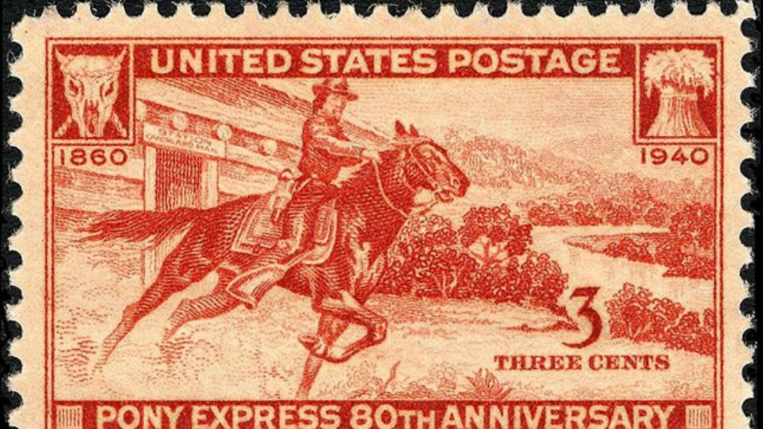
The Pony Express is one of the most enduring legends of the Old West. Unfortunately, most of the legend is historical bunk.

Despite the Pony Express’s short, ineffective run, thanks to Buffalo Bill (who as William Cody was one of the young men who rode for the company) and his entertaining wild west shows, the Pony Express has gone down in American history as a noble effort to provide speedy transcontinental communications. In fact, since 1907, it has been the subject of 15 movies, two made for TV movies, and a 1959 television series.

Although most of us seem to believe Russell’s effort was the first of its kind, people living at the time knew it was not. In fact, the U.S. Post Office itself ran a much more effective and heavily used Express Mail service that connected much of the nation during the 1830s. And unlike Russell’s PR stunt, it actually carried the U.S. Mail.

Designed primarily to carry financial news linking important, but far-distant cities in the West such as New Orleans and St. Louis with Eastern markets, the Express Mail had a couple branches. One of those Express Mail branches passed through our state of Illinois on the National Road (now U.S. Route 40), connecting Dayton, Ohio with St. Louis, passing through Vandalia, Ill.

John McLean, postmaster general, 1823-1829

Express Mail differed from the regular mail in that it was carried by a single man on horseback who was required to make the best time possible. Unlike the contracts for carrying the regular mail by stagecoach and wagon, Express Mail carriers could lose their contracts if they were late or missed a delivery.

Actually, Express Mail service was sporadically established at many times during the nation’s early history. Private express riders carried messages during the colonial period, then after the Revolution, most expresses were part of the military communications network.

The need for fast, universally available long-distance communications service became apparent in the spring of 1825. When a fast sailing ship arrived from England, New York cotton merchants, learned that cotton prices on the London market had skyrocketed. They then bribed the contractor carrying mail between New York and New Orleans to delay the news of the price jump. Meanwhile, the merchants rushed their buy orders to New Orleans ahead of the news so they could buy all the cotton they could find at low prices. When they sold the cheap cotton at the high prices in London, they made hefty profits. The cotton merchants who weren’t let in on the deal were not happy.

Postmaster General John McLean, who served from 1823-1829, vowed such a thing would never happen again, and prohibited mail contractors from carrying private messages “outside the mail,” meaning any messages carried by regular mail contractors, but not carried in the official portmanteau. During that era, the U.S. Mail was strictly defined as matter that was carried in the official portmanteaus, large canvas sacks with special locks. Mail contractors were threatened with loss of their contracts if they informally carried any messages that weren’t the mail. And that was a big deal, since without a mail contract, a stagecoach company simply couldn’t be profitable. In fact, at one time if a mail contractor lost his contract, he was obliged to sell his coaches, horses, and other equipment to the successful bidder.

In an effort to get the most important economic news delivered as quickly as possible, McLean decided to establish an Express Mail to travel what was called the Great Mail Line from New York to New Orleans. McLean’s expresses, however, only traveled a few times a year. It would be up to one of his successors to create a true Express Mail service.

Image result for amos kendall

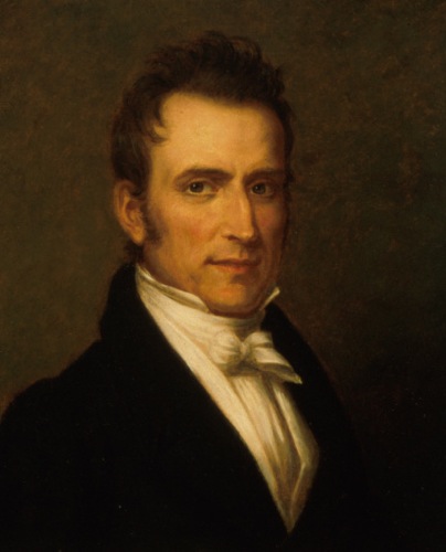
Amos Kendall, postmaster general, 1835-1840

In 1835, Amos Kendall took over the job of Postmaster General for President Andrew Jackson following a scandal that erupted when Postmaster General William Barry, who was not only incompetent, but also allowed politics to enter the mail carriage contract system. Barry’s corrupt incompetence drove the previously financially healthy postal service into bankruptcy.

Enter Kendall—our county’s namesake. Kendall was a former Tennessee newspaper publisher and crony of Jackson who turned out to have a genius for organization. In taking over from the corrupt Barry, he instituted a wide range of reforms, which, combined with a nationwide financial boom created huge postal revenue surpluses.

Kendall decided to spend his newfound surplus cash on a comprehensive Express Mail service carrying regular mail and newspaper “slips” along the New York to New Orleans route. Regular mail was carried in the Express Mail at three times the normal postage, while newspaper slips (described as “small parts of newspapers, cut out, or strips specially printed…to convey the latest news, foreign, and domestic”) were carried free of charge from town to town to spread the news. During that era, newspapers were considered vital to the proper functioning of a democracy, and thus the government had an interest in seeing the news of governmental happenings was spread as widely and as quickly as possible. Quite a difference from today.

President Jackson signed Kendall’s bill creating the Express Mail into law in July 1836, and the service began that same autumn. Within a few weeks, another express route was added from Philadelphia to Mobile, Ala. In 1837, two Missouri legislators prevailed on Kendall to establish a branch of the Philadelphia to Mobile express that branched off from Dayton, Ohio to St. Louis. The Illinois state capital at Vandalia was on that branch line of the Express Mail.

Starting on Oct. 1, 1837, express riders traveled from Dayton to Richmond, Ind. and on to Indianapolis. From Indianapolis, the route ran 72 miles to its terminus at Terre Haute, Ind. Two months later, on Dec. 10, 1837, the route was extended across the 99 miles of prairie from Terre Haute to Vandalia, and from there, 65 miles to St. Louis. Each stage of the trip was made daily by express riders.

The daily expresses made a considerable difference in the time it took for news to make its way west. In 1835, it took letters an average of 11 days and 15 hours to get from New York to Vandalia. Thanks to the Express Mail, that time was cut by almost two-thirds to just 4 days 15 hours.

But by late 1838, the days of the Express Mail were numbered. Thanks to the accelerating pace of railroad construction and major improvements to the nation’s road system, the regular mail had become nearly as fast as the express riders. As a Louisville, Ky. newspaper put it in 1838: “The rapidity with which the ordinary mail now travels from New York…makes it practically an express without the charge of triple postage.”

While overland travel was quickly improving the speed of the mails, the nation was also on the cusp of a telecommunications revolution that would, in less than a decade, supersede all existing communications technology. Samuel F.B. Morse invented his electric telegraph in the 1830s, and had largely perfected by 1845. In March of that year Morse and his partner Alfred Vail hired none other than former Postmaster General Amos Kendall (who’d left government service in 1840) to manage their business. Kendall, no fool he, agreed to work for a ten percent stake in the new company, which he incorporated as the Magnetic Telegraph Company. The expansion of telegraph service throughout the nation soon meant that spreading vital economic information was no longer limited to the speed of a horse, but could instead speed along copper wires. It revolutionized communications—which it continues to do to this day.

And Kendall had a hand in that success. After leaving the post office, he tried journalism and went broke (not uncommon even today) and was nearly a subject for debtor’s prison when Samuel F.B. Morse and his partner, Alfred Vail, decided to hire Kendall as their business manager to manage the business of promoting their new telegraph invention. It turned out to be a genius move as Kendall turned his organization skills to promoting the telegraph. And tt ended up making Kendall a multi-millionaire.

Kendall’s Express Mail, as a stopgap while the nation improved its transportation infrastructure and communications technology, was a success, keeping the nation tied together via the most sophisticated information technology the era offered. And it might be interesting to note that sending a one-page letter by Express Mail from New York to Vandalia here in Illinois in 1837 cost 75 cents—a time when land in Illinois was selling for $1.25 per acre. That certainly puts our seemingly endless modern postal rate increases into some historical perspective.


2 Comments

Filed under Business, Government, History, Illinois History, Kendall County, Local History, People in History, Transportation

Buying history is sometimes the only way it can be saved

A few years ago, I got an email from my friend Lyle Rolfe, who covers the Oswegoland Park District for our local community newspaper, the Ledger-Sentinel. He’d gotten a copy of the report I do every month for the board of the Oswegoland Heritage Association about the Little White School Museum here in town, and he noticed that we sometimes purchase items for our collections on eBay.

We don’t do a lot of that, but we probably average one item every couple months over a year’s time.

And thanks to those occasional eBay purchases, we’ve been able, for instance, to fill in the gaps of our collection of plaques manufactured by the Christian Art House here in Oswego from the 1930s to the early 1950s, and we’ve acquired a number of historically important postcards over the years, too.

One interesting postcard we purchased thanks to eBay ended up, like so many artifacts acquired for the museum, leading to us becoming more familiar with a couple interesting fragments of the Oswego area’s history.

1910 Horse tower trestle A b&w

The 1910 postcard showing the bell tower added to the old town hall in 1895 and the trolley trestle over the CB&Q tracks on Washington Street.

This particular postcard was mailed in 1910 from Oswego, and at first we thought the message on it was written in German. But it wasn’t necessarily the message on the postcard that caught our eye anyway. Instead, it was the view. The postcard’s photo was taken behind the retail businesses on the west side of Main Street, between Main Street and the (then) Chicago, Burlington & Quincy Railroad tracks, looking south. As a result, it showed the trestle on Washington Street that carried the interurban trolley tracks up and over the CB&Q tracks, which was interesting. But even more interesting was the view of the old Oswego Town Hall on Washington Street. It was one of the best views we’d seen of the hose tower that had been added to the hall after Oswego’s first pressurized water system was built and a fire brigade established.

2008 Twp Hall

The old town hall on Washington Street fell to the wrecker’s ball last year.

The tower was added to the town hall (built in 1884 as the village hall) in 1895 to house the village’s fire bell, and also to hang and dry the fire brigade’s canvas hoses after they were used.

The venerable old frame building was torn down last year to make way for a new business.

The bell the tower once housed, and which once called the village’s firefighters to action, is today the subject of a nice memorial out at the Oswego Fire Protection District’s new Station One on Woolley Road.

So we really wanted that postcard, and we were able to buy it very cheaply.

2010 March 5 fire bell remove

In March 2010, the old fire bell was moved from downtown Oswego to the new fire station on Woolley Road.

When we received the card, I immediately scanned it, and emailed a copy of the scan to a friend I knew could read German. He, however, informed me the card was not written in German, but in Danish!

Danes? In Oswego? Why, yes, actually. Turns out there was a small contingent of Danes living here, one of whom was Johann Schmidt, who had sent the postcard from Oswego to Denmark in 1910.

So we had a couple tasks. First, find someone to translate the card’s message, and second figure out who the heck Johann Schmidt was.

For help translating the card, I went to hNet, an Illinois network of professional historians. While I’m not one, they graciously allow me to participate from time to time. With their help we found native Danish speaker Anni Holm at Waubonsee Community College, who volunteered to translate the postcard.

According to her, the card was sent by Schmidt to his nephew, Max Schmidt, in Marstal, Denmark, congratulating the younger Schmidt on his recent confirmation, and explaining about the elder Schmidt’s prize stallion. Here’s Anni’s translation:

“Dear brother son Max S.

Have received your card and thank you for the applications. Yes, I am well and have it good. Hope the same for you and will I here wish you congratulations and a blessed confirmation, it is sad that I could not attend [unreadable word] to your confirmation

Your uncle Hans J. S.”

1910 Horse tower trestle B

The message side of the 1910 postcard, which turned out to have been written in Danish.

On top of the card the upside down text says the following: “this stallion as you see of the picture has been mine and it is hyre [Danish for hired] man who walked with it”

And who was Johann Schmidt? Turns out he was a prominent Oswego saloonkeeper during the early 1900s. Going by the names Johann Schmidt, John Schmidt, Shorty Smith, and John Smith, he owned The Oswego Saloon, which, when it was under construction in 1897, Lorenzo Rank, the Kendall County Record’s Oswego correspondent, predicted:

“It will by far be the most gorgeous establishment of the kind that Oswego ever had.”

Just to sow a little more local history confusion, Rank added in March 1898:

“J.A. Schmidt and Ira Ackley have been doing the decorating of the new saloon building, all of which is most magnificent. Every room is of different color and pattern. The wine room–well, gorgeous or splendid–fail to express the sight of it.”

The J.A. Schmidt doing the decorating was not the Johann Schmidt who eventually bought The Oswego Saloon. J.A. was a German, a native Berliner, who worked around the Oswego area doing painting and wallpapering.

Johann Schmidt the saloonkeeper was a Dane who bought The Oswego Saloon from Al Cole in November 1904, and continued to run it as Oswego’s premier drinking establishment until prohibition closed it down.

So successful was he, in fact, that Schmidt was the victim of a strong-arm robbery. According to the Oct. 16, 1907 Kendall County Record:

HIT WITH AN AX;

ROBBED OF $300

John Schmidt, Oswego Saloon-Keeper,

Knocked Unconscious Last Night.

John “Shorty” Schmidt, one of the Oswego saloonkeepers, was going home last night from his place of business about 11 o’clock when he was attacked from ambush, hit on the head with an ax, and relieved of a roll if bills amounting to $800.

Mr. Schmidt lives in one of the small cottages along the railroad track below the village hall and it is his custom to go around the end of the town house, taking a shortcut to his own rear door. At the end of the village building is a clump of bushes and as he was passing those bushes he was suddenly felled to the ground with a heavy blow on the head. He was unconscious for about 15 minutes, and while he was senseless the hold-up men took his money. He is confined to his home this morning with a deep gash on the back of his head, which came near being a fractured skull.

So we gained a lot of interesting Oswego history with a vanishing small investment in a single postcard we were able to find thanks to eBay. And that’s the way local history rolls. Bit by bit, you build up a store of information that you can, when a key part finally becomes available, synthesize and arrive at some valuable insights.

“How do you go about researching local history,” a friend asked me not long ago. He’s right to be perplexed. It’s not like you can go to some Internet source and find out all about early 20th Century Oswego saloonkeepers of Danish descent.

Rather, this is how we do it, one bit at a time, until a key piece drops into place and makes the story whole, or at least as whole as it can be until the next bit is discovered and, in turn, drops into place.


Leave a comment

Filed under Architecture, Government, History, Kendall County, Local History, Oswego, People in History, Semi-Current Events

“Picturing Oswegoland”

We opened a new special exhibit at the Little White School Museum here in Oswego on Aug. 1 titled “Picturing Oswegoland.”

The museum is located at 72 Polk Street (Jackson at Polk), just a couple blocks east of the historic downtown business district here in Oswego. Hours are 10 a.m. to 5 p.m. Monday through Saturday and noon to 5 p.m. Sunday. Admission is free, but we don’t turn donations down.

The exhibit was the brainchild of my fellow volunteer, Bob Stekl, who is the museum’s assistant director, and includes a few more than 240 images of Oswego and the surrounding area that date from the 19th Century through the 20th Century and into the 21st Century.

Since this blog’s readers don’t all live in or near Oswego, I thought I’d put up a selection of the images now on exhibit so you can get an idea of what it’s like. “Picturing Oswegoland” will be up through Sept. 1, so you’ve got a couple more weeks to go if you’re up to planning a visit.

Here are the images I selected:

1890 Harvey Threshing Ring B

Farmers in the area of Wolf’s Crossing and Harvey roads were members of the Harvey Threshing Ring. The small grains (oats, wheat, barley, rye) was pretty labor-intensive back in the day.

1898 Aurora Golf Club at Boulder Hill

Not many people know the Aurora Country Club got its start at the Boulder Hill Stock Farm–site of today’s Boulder Hill Subdivision. The clubhouse (top) was the A.C. Hyde House, which is still standing on Briarcliff Road.

1900 abt German Evangelical Church

The Church of the Good Shepherd United Methodist is still a community landmark after standing at Washington and Madison streets for well over a century.

1900 Haag Farm Steam Engine

They used some serious equipment to thresh grain back in the day.

1903 (abt) Trolley S. on Main.jpg

In 1903, you could hop the interurban trolley car at Main and Washington streets for a trip to Aurora to shop or to go to high school or work. The two ladies at right have just gotten off the trolley and are walking home. Note the horse and buggy on Main Street.

1903 wagon crossing river

Another 1903 image we believe was taken by Mary Cutter Bickford looking north towards the bridge from behind the houses along South Main Street.


1904 Main at Wash look N

A nice postcard view of the Main Street business district looking north. Note the trolley tracks at left and the trolley’s electrical wires above the tracks. And you can’t miss the tangle of telephone lines on the poles on the east side of Main Street as two phone companies battled each other.

1905 OHS baseball

The 1905 Oswego High School Baseball Team on the steps of the old Red Brick School. The boys are wearing hand-me-down jerseys from the East Oswego men’s baseball team that was mostly comprised of farm boys from the Wolf’s Crossing Road area.

1910 5 Jun 3.30 pm Scan

One of my all-time favorite Oswego photos, snapped by Daniel Bloss at exactly 3:30 p.m. on June 5, 1910. Talk about your shapshots in time!

1910 Lumbard School, Amanda Hummel teach.jpg

The student body of the Lumbard School, often incorrectly called the Lombard School, that was located over in the Hafenrichter Road area. Check out all the barefoot kids…no dress code back then!

1911 abt Washington St. hill winter

Another one of my favorite Oswego shots, taken on Washington Street at Main, looking east towards what was then the German Evangelical Church. It nicely illustrates the era when automobiles were beginning to displace horse-drawn transport.

1911 Fox River Park Scene

The Oswego area once had its very own amusement park, Riverview Park, located on the site of the old Western Electric plant right across the river from Boulder Hill. It was a happening place with visitors taken there by the trolley line that ran from Aurora to Yorkville.

1913 Fox River Park with coaster.jpg

Another Riverview Park postcard view. The name was changed about 1906 to Fox River Park to differentiate it from the much larger Riverview Park in Chicago. Fox River Park featured a rollercoaster, giant merry-to-round, shoot the chutes, boating, and much more.

1912 Acme Binders

In 1912, Oswego implement dealer Bob Johnson sold 25 new Acme binders that arrived just in time for that year’s small grain harvest. The binders paraded through town down to “The Flats” just above the Oswego Bridge for this group photo before their owners drove them home.

1912 Red Brick exterior

A nice view of the Red Brick School before the 1920s classroom and gymnasium addition. The photo was taken by Dwight Young.

1922 (abt) Weishew Clinic

Dr. Lewis Weishew built this medical clinic at Main and Van Buren Streets in 1922. This photo was probably taken shortly after the building was finished.

1927 Parke Building

Earl Zentmyer bought the A.O Parke building on Main at Jackson Street  from Gus Shoger and opened his first Ford dealership and gas station in it. He eventually bought the old livery stable across Main Street from it and moved his dealership there, although he retained ownership of the building.

1930 Leapfrog at Bronk School.jpg

Nothing like a spirited game of leapfrog during recess, I always say. Bronk School, which marked the southern edge of the Oswego School District, was located at Caton Farm and Ridge roads–and still stands as a private home.

1933 Downtown Oswego, looking N from Washington St

Downtown Oswego all decorated up to celebrate the community’s centennial in 1933.

1940 Schultz Grocery Store freezer

Charlie Schultz (left) and Carl Bohn show off their brand new Birdseye frozen food display case in downtown Oswego in 1940.

1942 "Dinky" at Oswego Depot

The CB&Q’s gass-electric passenger car, nicknamed “The Dinky” by its riders, pulls out of the Oswego railroad station in 1942 on its way south through Yorkville and Ottawa to Streator. Passenger service was offered until 1952 when it was replaced by bus service.

1944 Sept saying pledge outdoors cropped

Saying the pledge at Church School out in Wheatland Township during World War II.

1949 Nehru visits WA Smith farm

The area enjoyed the occasional visit from an international celebrity, including a 1949 visit from the Prime Minister of India.

1954 St. Anne's Catholic Church

Postcard celebrating the opening of St. Anne’s Catholic Church in 1954. The reason it looks like half a building is because it was. Original plans called for eventually doubling the church’s size with an addition to the east, but instead a new church was built on Boulder Hill Pass.

Oswego High School, spring 1957. Little White School Museum photo.

I was in the last high school class to graduate from this building in the spring of 1964. Then it became Oswego Junior High and later Traughber Junior High.

1957 Willow Hill School

Speaking of schools, Willow Hill School was one of the last one-room schools in the Oswego School District. This photo was taken by Everett Hafenrichter.

1958 Bypass const at Playhouse

Building U.S. Route 30 Bypass in 1958, with the Boulder Hill Playhouse in the background.

1958 Wormley Campbell's Tomato farmer

Oswego’s Jim Wormley’s dad, Myron, was one of the many area farmers who raised tomatoes commercially in the 1950s. His son, Jim, became one of the advertising faces of Campbell’s Soup.

1960 basketball game

Everyone’s pretty excited at this basketball game in this photo from the 1960 Oswego High School yearbook, The Reflector.

1961 Federated Church

Leonard Hafenrichter captured this snapshot of the Federated Church–now the Church of the Good Shepherd–in the spring of 1960.

1965 Sept Oswego Depot & Engines retouch

CB&Q locomotives rumble past the Oswego Depot in September 1965.

1977 OHS Varsity Coach Dave Babcock

Dave “Chopper” Babcock encourages players during the 1977 varsity football season. I believe this is a Jon Cunningham photo, but am not sure.

1998 Oswego Prairie Church

This landmark out on the Oswego Prairie, with its lighted cross atop the bell tower, is still standing.

Stop by the museum from now through Sept. 1 and see all the images we’ve selected to exhibit from our collection of more than 10,000 prints, negatives, transparancies, tintypes, Daguerreotypes, and Ambrotypes. After all, it’s free, and it will be your last chance for a while to see most of these before we put them away again.

The Little White School Museum is a cooperative project of the not-for-profit Oswegoland Heritage Association and the Oswegoland Park District.


Leave a comment

Filed under Architecture, Education, entertainment, Farming, Fox River, History, Kendall County, Oswego, People in History, Technology

Pestekouy River Valley? Not for the past 331 years

Names of things have always fascinated me, and I guess they sometimes interest other people as well. I know that when I speak to various groups about local history, one of the most-asked questions is, “How did Oswego get its name?” Although Oswego, Illinois was named after a long-settled city in New York state, its name of Mohawk Tribe origins, many of the names of local geographical features originated right here.

For instance, a good example of a major local feature of interest is the Fox River. The Fox had been tagged with its present name several decades before the first American pioneer settlers arrived along its banks. The Fox River, as a matter of fact, was well known to explorers and map makers for well over a century before the first American settlers arrived in the area in the late 1820s.

Marquette & Jolliet

Cartographer and explorer Louis Jolliet and Father Jacques Marquette were the first Europeans to see the Fox River during their 1673 expedition.

The very first explorers who traveled through Illinois noticed the Fox River. In 1673, Louis Jolliet and Father Jacques Marquette, S.J., led an expedition to discover where the Mississippi River’s mouth was located. The French hoped the Mississippi bore to the southwest and that its mouth was on the Pacific Ocean. By the time Jolliet and Marquette reached the mouth of the Arkansas River they were certain the Mississippi headed due south and that its mouth was probably somewhere on the Gulf of Mexico and definitely not anywhere near the Pacific.

Jolliet, an experienced cartographer, drew a map of the expedition’s journey after he arrived back in Canada following the trip. Although the most familiar edition of this map was probably not drawn by Jolliet, but rather used his information (his name is misspelled on the map), it does show the course the expedition took. It also shows the Fox River, although the stream is unnamed.

1683 Franquelin map

Franquelin’s 1684 map of LaSalle’s colony shows a number of Native American towns clustered around Starved Rock. The map shows the mouth of the Riviere Pestekouy–our Fox River–just above Starved Rock.

Rene-Robert Cavelier, Sieur de la Salle was an intrepid French explorer and unsuccessful businessman who, using Jolliet and Marquette’s information, attempted to colonize Illinois beginning in 1679. LaSalle made several trips to the area before getting his trading empire started at the fort he built atop Starved Rock. Starved Rock, just as imposing three centuries ago as it is today, was called le Rocher by the French.

Jean-Baptiste Louis Franquelin, LaSalle’s cartographer, drew a fairly accurate map of the area comprising LaSalle’s proposed colony in 1684. On this map, the Fox River appears, but is referred to as the Riviere Pestekouy. Pestekouy was the French spelling of an Algonquian Indian word for the American bison.

Clearly, the residents of the several Indian villages located on the map along the Pestekouy River must have hunted the herds of the Eastern Bison that roamed the Illinois tallgrass prairies during those years, thus giving the river its name.

Franquelin drew another map of the area in 1688, which while more accurate than his 1684 map, still called the river Pestekouy.

In addition, Marco Coronelli, a Venetian Conventual friar, produced a map in 1688 based on gores he made for a globe in 1687, on which the Fox River is labeled Pesteconti R. It seems pretty clear that Pesteconti is an Italianization of the French Pestekouy, which is not surprising since Coronelli got most of the information for his map and globe from French sources, including Franquelin.

After Franquelin and Coronelli’s maps, cartographers stopped putting a name on the Fox River for several years.

In fact, as early as 1684, Minet, an engineer and cartographer who accompanied LaSalle, published a map with the Fox River drawn in but not named. After Coronelli’s map was published, the name Pestekouy seems to have vanished from maps.

For instance, Louis de La Porte de Louvigny in 1697 and Guillaume Delisle in 1718 both produced fairly accurate maps of the interior of North America, including the Fox River Valley, but did not label the Fox River with any name at all. The reason for this is unknown, but was probably due to the fact that the area had lost whatever economic significance it had gained during the LaSalle period due to a combination of factors, including the hostility of the Fox Indian Tribe.

1754 Ottens map detail

This detail from Ottens’ 1754 map shows the Fox River labeled as R. du Rocher, probably because of the proximity of its mouth to Starved Rock–named du Rocher by the French.

By 1700, the French trading center at le Rocher had been moved south to Fort Pimiteoui on Lake Peoria, and along with it had gone French military power in the upper Illinois and Fox River valleys. The Fox Tribe had prohibited the French from the area south and west of Green Bay, and that included use of the portage from the Fox River of Wisconsin that empties into Lake Michigan at Green Bay and the Wisconsin River that offers a good route to the Mississippi. For more than 30 years, the French and their Indian allies battled the Fox to secure access to the area northwest of Chicago. In 1730, the French and their Native American allies vanquished the Fox for the final time, opening the area to French trade and missionaries.

In 1754, after the French had in essence exterminated the Fox, an interesting map was published in both French and Dutch titled Map of the English and French possessions in the vast land of North America. The map was published in Amsterdam by Cartographer Josua Ottens. Interestingly enough, the Fox River is named R. du Rocher on Ottens’ map, which was quite a change from Riviere Pestekouy. It seems likely the name was derived from the Fox River’s mouth’s proximity to the old French post at le Rocher. It may well be that the French traders in the area had renamed the river after the old fort at le Rocher after the trouble with the Fox Tribe was settled.

1778 Hutchins map detail

Detail from Thomas Hutchins’ 1778 map showing the Fox River with its modern name.

It was a few years after Ottens’ map was published that our river officially received its present name. By 1764, the French had been defeated in the final French and Indian War—called the Seven Years War in Europe. British troops slowly moved into the vast area north and west of the Ohio River that had been controlled for so long by the French.

Thomas Hutchins, an engineering officer with the British 60th Royal American Regiment, traveled throughout the area between 1764 and 1775 with his regiment. In 1778, Hutchins published a map of North America titled, in part, A New Map of the Western Parts of Virginia, Pennsylvania, Maryland and North Carolina; Comprehending the River Ohio, and all the Rivers which fall into it; Part of the River Mississippi, the Whole of the Illinois River.

On this map, published the same year that George Rogers Clark conquered Illinois for the state of Virginia during the Revolution, the Fox River was given its modern name. It is not known why Hutchins recorded the river’s name as the Fox River, but the Fox Tribe’s occupation of the area in the northern reaches of the Fox River Valley probably had a lot to do with the renaming of the stream.

Whatever the reason, the name stuck and was included on the first official map of the state of Illinois drawn by John Melish and published in I819. And Fox River it has remained ever since.


Leave a comment

Filed under Environment, Fox River, Fur Trade, History, Illinois History, Local History, Oswego, People in History, travel