Monthly Archives: May 2020

Nathan Hughes: An escaped slave who fought for freedom during the Civil War

Another Memorial Day has rolled around, this time with the nation in actual peril, thanks to a new highly contagious disease, for the first time in a many years.

1898 abt Decoration Day Parade

Procession marching through downtown Oswego on Decoration Day, around 1910. Parade Marshal George White leads the parade, which usually consisted of a marching band, civic and fraternal organizations, and citizens. When the procession reached the Oswego Township Cemetery, a short memorial service was held for the community’s Civil War dead, after which Oswego school children decorated the graves of deceased veterans with flowers.

Originally established to honor the graves of Civil War soldiers and so named Decoration Day, today’s Memorial Day honors all the nation’s military personnel who have died.

As wars go, the Civil War has never been my favorite area of historical study. Better named the War of Treason in Defense of Slavery, the war pitted the largely rural Southern states against the North and its mix of rural and industrialized urban areas. Both sides were unlucky in the military commanders they chose to lead the fight against the other side. It took a few years before the North’s crop of military leaders was finally distilled down to no-nonsense men like Ulysses Grant and William Sherman, Grant invaluable because of his grasp of strategy and Sherman for his tactical brilliance. Meanwhile, the South chose Robert Lee as their military leader, a man whose grasp of the kind of strategy required to defeat a stronger foe was disastrously flawed. The result was more than 600,000 killed in action, dead of wounds, and perished from disease.

Here in Kendall County, more than 10 percent of the total population went off to fight and the war’s lasting effect was to see the county’s population steadily decline for the next century until it finally surpassed its 1860 total in 1960.

But while the South was soundly beaten militarily during the war, it immediately began fighting to win the peace, which it did. Reinstituting the terrorism that had kept the South’s slave population in line, the Jim Crow era was, if anything, even more violent than slavery itself. And the South’s efforts to redefine the cause of the war was just as successful. By the time I was in high school a century after the war was fought, we were taught that the underlying cause of the war was state’s rights. Slavery, we were told, was a dying institution at the time and would have ended had the war never been fought.

Neither of those were true. The war was mainly fought over the South’s continuing, and increasingly unsuccessful, efforts to expand slavery into the new territories being brought into the Union. All of the existing resolutions of secession passed by Southern state legislators mention the North’s attitude towards slavery as a major cause, if not the major cause, of the states’ secession. Union. And as for being on the way out, slavery was financially lucrative in the extreme. In fact, the value of all the South’s slaves was more than the value of all of the North’s industrial, railroad, and banking facilities.

As for the Civil War itself, a little over a century and a half ago this month, the conflict was in full swing with the ultimate result still very much in doubt.

While the Union was still convinced it could defeat the rebellious secessionists if just given a little more time, reality was staring to intrude. It would take more years of blood and treasure to finally stamp out the rebellion begun by the South’s pro-slavery forces.

It would also take a lot more soldiers—by 1864, the Union was scraping the bottom of the personnel barrel. But there was an as-yet untapped resource: thousands of black men who were already living in the North and areas in the South controlled by the U.S. Government. Some were Northern-born and wanted to fight; others had escaped from slavery and were eager to do their part to ensure freedom for everyone in the nation.

Many blacks were already serving in support roles as teamsters and other noncombatant jobs. Others were serving in combat with state units, such as the famed 54th Massachusetts Infantry Regiment, the subject of the film, “Glory.” But on May 22, 1863, with the number of potential soldiers drying up across the North, the War Department issued General Order 143, establishing the United States Colored Troops. Regulations called for all officers to be white, although non-commissioned officers—corporals and sergeants—were to be promoted from the ranks.

However, some light-skinned blacks passed for white in order to serve as officers, like William N. Reed, a New York abolitionist. Reed graduated from the German military school at Kiel and had served in the German army. Arriving back in the U.S. he managed to obtain a commission as colonel of the 1st. North Carolina Colored Infantry Regiment, later reorganized as the 35th U.S. Colored Infantry. Reed is recognized as the highest-ranking African American in the Civil War

US Colored troops recruitment
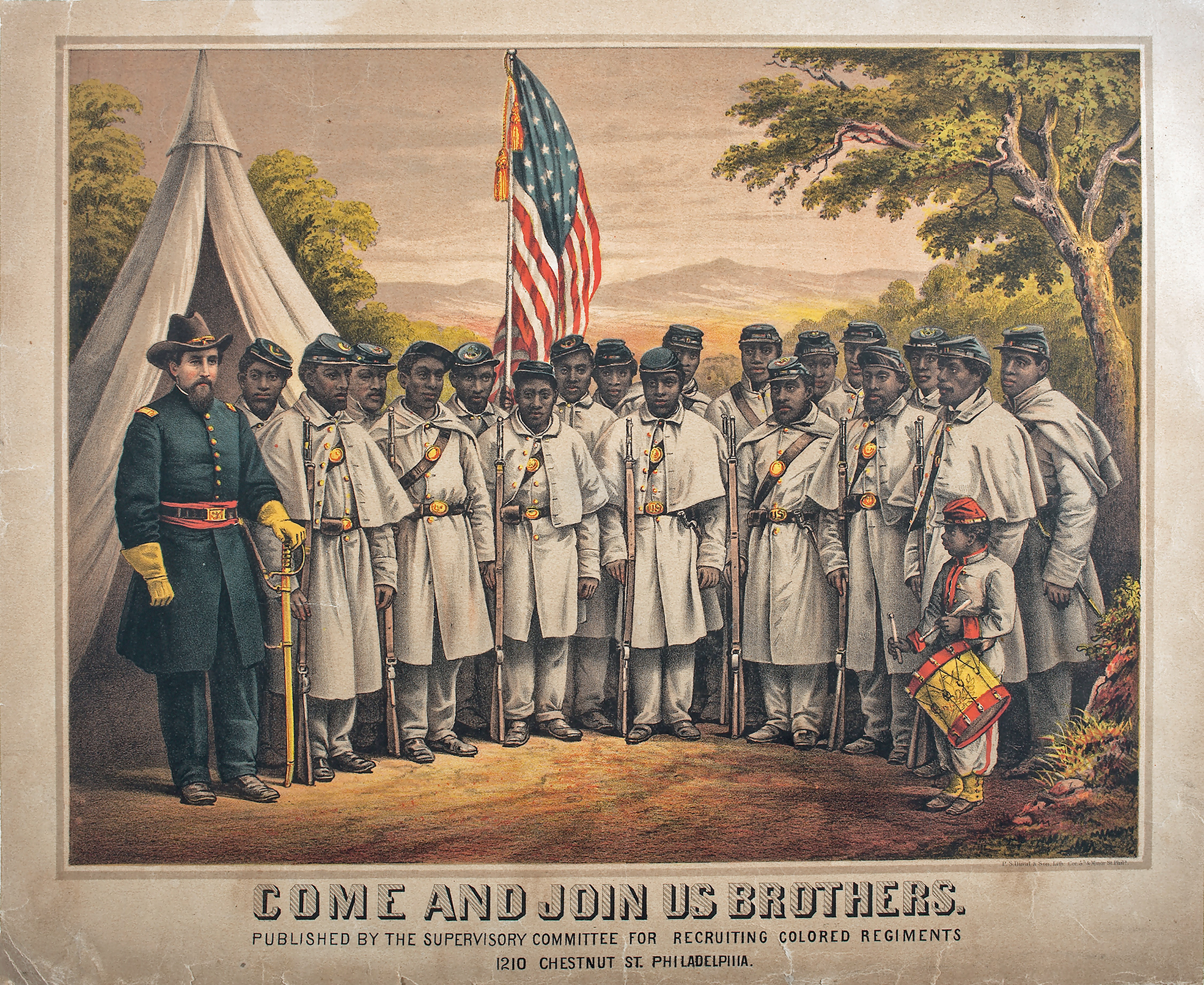
Illinois Gov. Richard Yates began raising a regiment of colored troops late in 1863, but the early efforts were slow, due to a combination of factors including lower pay for black soldiers and the brutal treatment black prisoners of war received at the hands of the rebels. But gradually the regiment’s companies were filled with volunteers from all over the state until it was ready to be formally accepted for service at Quincy on April 24, 1864.

Although U.S.C.T. (U.S. Colored Troops) regiments were not always fortunate in their commanders, the 29th was, with Lt. Col. John Bross of Chicago, a skilled, knowledgeable veteran, in command. The regiment was assigned to the Fourth Division, IX Corps of the Army of the Potomac, the first black division to serve with the Union in the Virginia theater.

Among those who enlisted in the 29th, was an escaped slave named Nathan Hughes. According to his military records, Hughes was born in Bourbon County, Ky. and was, according to his family’s tradition, of mixed black and Seminole ancestry. Like many slaves, he was apparently unsure of his birth date. His military records stated he was 33 when he enlisted in 1864, making his birth year 1831. However, his family had a birth date of 1824 inscribed on his tombstone.

Whatever his age, Hughes managed to escape slavery, but in doing so was forced to leave his family behind. Reaching Illinois, he apparently settled near Yorkville and worked as a laborer until he volunteered for service in the 29th, enlisting in Company B under Capt. Hector Aiken.

While the 29th was fortunate in its commanding officers, it was not so lucky in those assigned to command the Fourth Division, nor the IX Corps to which it was assigned. Gen. Edward Ferrero the division commander, was a former dance instructor of middling ability, and the corps commander, Gen. Ambrose Burnside, was better but no military genius. After reaching the Virginia front where Union forces besieged the rebel capital of Richmond, the 29th was assigned to protect the Union Army’s supply lines, participating in a number of skirmishes. On May 9, 1864, the 29th was instrumental in throwing back a determined rebel assault on some vital Union supply convoys.

After Gen. Ulysses Grant took command of the Union armies, he orchestrated a campaign designed to destroy the main rebel force, the Army of Northern Virginia, using a series of flanking movements gradually forcing the rebel army back on the Confederate capital of Richmond, Va. Richmond was not only valuable as the rebel capital, but also because of its industrial facilities and its position as a rail hub—the Civil War was the first railroad war and the lines were vital to supply the huge armies involved.

But the siege of Richmond was not something Grant wanted. He had pursued rebel Gen. Robert Lee in a series of hard marches and battles through the Wilderness, Spotsylvania, and Cold Harbor unsuccessfully trying to corner him before Lee was run to ground in the extensive defensive works around Richmond.

Grant knew the heavily fortified Richmond suburb of Petersburg was the key to the rebel position, but could see no way to break into it. While Lee was a good tactician and a middling strategist, he was a fine military engineer.

Battle of the Crater

This detail from a Tom Lovell painting shows the ferocious combat that took place between rebel troops and United States soldiers during the Battle of the Crater at Petersburg, Virginia.

So the two armies, the Union Army of the Potomac and the rebels’ Army of Northern Virginia settled down in a siege neither side wanted. Enter the coal miners serving in the Union Army’s 48th Pennsylvania Infantry, who proposed to dig a tunnel under the rebel works. The idea was to hollow out a large open cavern under the rebel fortifications, fill the cavern with gunpowder, and blow up the rebel works. The mine was completed, the charge blown up, and a huge break in the rebel lines was created. But the Union assault was a confused failure, thanks to incompetent commanders. The Battle of the Crater that took place as Union troops, including Ferrero’s U.S. Colored Troops, attempted to exploit the new break in the rebel lines was depicted from the Southern point of view in the 2003 film “Cold Harbor.” It was a Union disaster.

The 29th U.S. Colored Infantry was one of the regiments that were part of the assault force, and during the melee, Nathan Hughes was badly wounded, shot in his left knee. He must have been a tough guy because unlike so many Union soldiers, Hughes survived the serious wound, including being sent to a military hospital. He not only survived but was returned to duty months later, just in time to be wounded again, this time less seriously in the hand. Doing hard marching with the 29th, Hughes fought through the battles and skirmishes of Boydton Plank Road, Globe Tavern, Poplar Grove Church, and Hatcher’s Run before Grant was able to bring the Army of Northern Virginia to bay at Appomattox Courthouse, Lee’s surrender in April 1865 effectively ending the war. The 29th was then sent down to Texas to watch the border with Mexico thanks to French meddling with that country while the U.S. was distracted with its internal conflict. The regiment was mustered out of U.S. service in November 1865.

After being mustered out with the rest of the regiment in Texas, Hughes returned to Illinois where he decided to settle on a small plot in Kendall County near Oswego on today’s Minkler Road. Like many escaped slaves forced to leave their families behind during their desperate flight north, Hughes headed back to Kentucky after the war to try to retrieve his wife and children. His three children decided to go back north with their father. His wife, for whatever reason, decided to stay in Kentucky. It must have been a wrenching decision to watch her children leave, but it must also have been an almost impossible choice for those who had been considered property only a few months before to make another such momentous change in their lives. I suspect the PTSD suffered by former slaves, as well as many of the men who served during the war, was a real burden for thousands for many years after the war.


1893 Hughes, Nathan & Wife

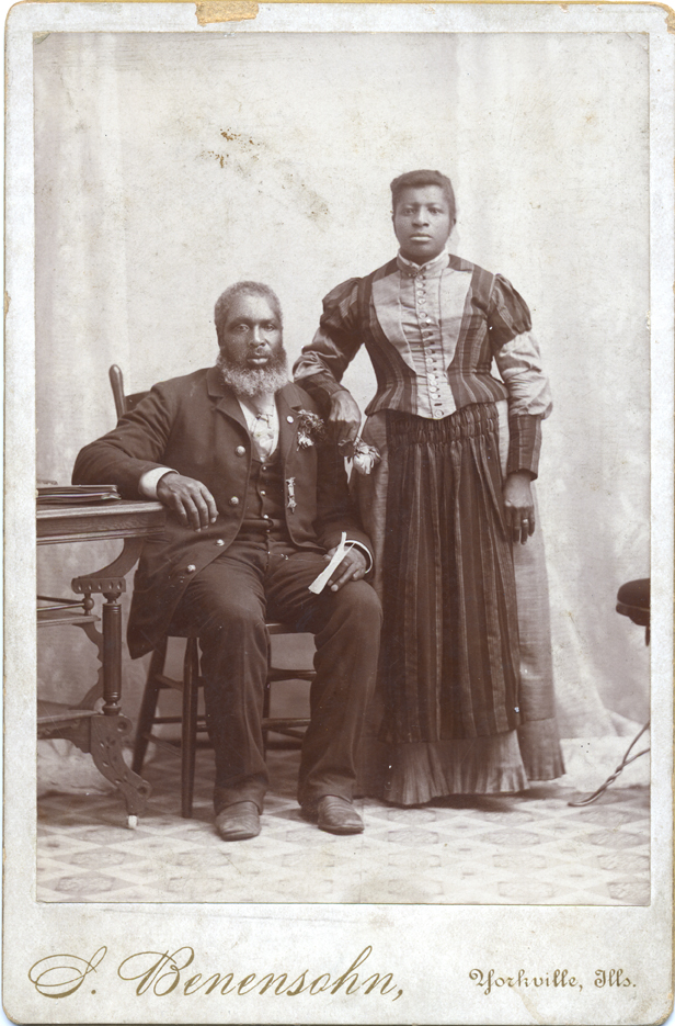
In 1893, Yorkville photographer Sigmund Benesohn took this portrait of Mr. and Mrs. Nathan Hughes. Hughes is proudly wearing his Grand Army of the Republic lapel pin. Confederate Army canons were melted down to make the pins. (Little White School Museum

Nathan Hughes came back to the Oswego area with his children, eventually remarried and lived for the rest of his life on his small farm on Minkler Road southwest of Oswego. He was a respected member of the farming community there, and was the only Black member in Kendall County of the Grand Army of the Republic, the Union veterans’ organization, where he served as an officer of the GAR’s Yorkville post.

His children married into the nearby Black farming community, most members of which eventually moved into Aurora where jobs in the city’s many factories were more attractive than the labor-intensive, low income farming of the late 19th and early 20th centuries. His descendants prospered, two of his grandchildren becoming the first Black male and first Black female to graduate from high school in Kendall County (both from Oswego High School). And their descendants prospered, too, becoming elementary and high school teachers, and college professors—and at least one Federal judge.

Hughes died in March 1910, and was buried in the Oswego Township Cemetery, where he lays today with four of his black Civil War comrades. Wrote Kendall County Record Publisher John R. Marshall—himself a Civil War veteran—upon Hughes’s death: “It is a pleasure to bear testimony to his worth as a man and a patriot; he was loyal to his country and in all his associations was a quiet, self-possessed man of the best of traits… A good citizen, he has left a vacant place in the ranks of the ‘boys in blue.’”

4 Comments

Filed under Civil War, History, Illinois History, Kendall County, Local History, Military History, Oswego, People in History

Maramech Hill area a historical gem—just not the one many believe it to be

Maramech Hill, located between Big Rock and Little Rock creeks just upstream from where the combined streams enter the Fox River, has been a celebrated local historical site for more than a century. Once touted as the site of a climactic battle between colonial French forces and their allies and the Fox Tribe, the area around the hill has become one of Kendall County’s premiere cultural and natural destinations.

Maramech Hill Area

The Maramech Hill area of Kendall County. Click here to enlarge.

Part of the area’s story begins during Illinois’ colonial era.

Warfare between Europeans and Native Americans began almost as soon as Europeans arrived in the Western Hemisphere.

In South and Central America, and a portion of southern North America, the Spanish waged a series of very successful wars of extinction against the native populations.

For most of North America, however, the situation was quite different. A series of powerful, adaptable, Indian tribes made the conquest of North America anything but a sure thing. Eventually, however, European numbers and technology won out over the Indians. But it was a tough, generations-long struggle.

For instance, the area that now includes the states of Kentucky, Tennessee, and West Virginia was known as “the dark and bloody ground” long before colonial American frontier settlers began filtering into it.

Maramech Hill site with timber

The Maramech Hill area (between the two creeks), during the settlement era, was surrounded by tall timber as the original survey map from 1838 shows. Click to enlarge.

Claimed as a prime hunting and trapping ground by the native tribes of the Shawnee, Delaware, Miami, and Huron people, the region was the location of nearly continuous intertribal warfare. It was warfare made worse when European colonial powers began playing the tribes off against each other in a quest to dominate the trade in furs. By the mid-1760s, the Europeans’ wars against each other had largely been settled in favor of England. English peace efforts included issuing a proclamation declaring a no-go zone for settlers west of a line that roughly ran along the peaks of the Appalachian chain. That effort failed spectacularly as American colonials flooded across the mountains to settle the region, touching off even more warfare with and between the tribes. A “dark and bloody ground,” indeed.

But it’s not so well known that nearly a century before those events took place, northern Illinois and southern Wisconsin and Michigan could have been accurately described as a dark and bloody ground as well, primarily because of a decades-long war between the French colonial government and the Fox Tribe.

The Foxes call themselves Meskwaki, or people of the red earth. The French, after encountering the tribe, referred to them as the Outagami or the Renards—French for fox. The tribe was first recorded living along the St. Lawrence River in modern Ontario. But warfare resulting from side effects of the fur trade—primarily conflict with the Huron Tribe—pushed the Foxes west, first to lower Michigan and then, eventually, to the Green Bay area of Wisconsin. So the Foxes arrived in our region with built-in animosity towards the French as well as a favorable feeling towards the Iroquois, deadly enemies of both the Hurons and the French.

Through that series of wars and forced relocation, the Foxes became a pugnacious people. Part of the great Algonquian-speaking majority of Native tribes in northern North America, they were members of a linguistic subgroup with the Sauks and Kickapoos.

After being driven out of eastern Michigan by the Ojibwas, the Foxes were involved in fairly constant warfare with that tribe. The Foxes also engaged in sharp battles with the Sioux in western Wisconsin and eastern Minnesota. The Illinois, Potawatomis, the Miamis, and several other tribes in the upper Midwest were also often at odds with the Foxes.

Franquelin map color

Franquelin’s map of LaSalle’s colony in 1684 shows what early 20th Century advocate John F. Steward believed was Maramech Hill near Plano.

The warfare was bad for the business of the fur trade (especially their efforts to trade with the Sioux) and the French tried to stop it by weighing in on the side of the Foxes’ numerous enemies. This led the Foxes to cultivate ties with the powerful and ruthless Iroquois Confederacy, who were friends of the British and implacable enemies of the French and their Algonquian-speaking Native allies.

The Foxes’ actions to become the middlemen for the fur trade west of southern Lake Michigan—and to deny French firearms to the Sioux—resulted in denying the use of the strategic and economically valuable portage between the upper Fox River of Wisconsin and the Wisconsin River to French trading interests. Instead, French traders had to use the longer and far more difficult Chicago Portage. And if that wasn’t bad enough, cozying up to British interests eventually persuaded the French that the Foxes had to be destroyed.

In 1710, a large group of Foxes—not the entire tribe—agreed to move adjacent to the French fort at Detroit, ostensibly to live under the protection of the French military. However, given the Foxes’ long animosity toward the French and their Indian allies, the Foxes were soon—and predictably—embroiled with disputes against French interests. In 1712, the disputes led to a Fox siege of the French fort, with the Foxes heavily and skillfully fortified inside their own camp. Eventually, Indian allies of the French arrived to lift the siege and to besiege the Foxes. The stalemate lasted nearly a month until the group of Foxes, out of food and water, attempted to escape during a thunderstorm. They were unsuccessful, and virtually the entire band was destroyed.

The rest of the Fox Tribe, not surprisingly, was infuriated. They retaliated by killing French traders and several members of the tribes allied with France. At the same time, the Foxes mounted a diplomatic offensive, and concluded a treaty with their old enemies, the Sioux, to eliminate the threat of an attack on them from the west.

Kee-Shes-Wa Fox Warrior

Kee-Shes-Wa, a Meskwaki chief, painted by Charles Bird King in the early 1800s.

In response to the Foxes’ military actions, in 1715, the French attempted to launch a punitive expedition but those efforts were badly planned, and failed. The Foxes used the respite to build a strong, well-planned fortification on the Fox River of Wisconsin that empties into Green Bay. The fort’s walls were made of oak logs reinforced with earth dug out of trenches inside the fort.

When the French and their allies finally attacked in 1716, they used artillery and formal European siege tactics to attack the Foxes’ fort. However, the Foxes held out against the French and their allies, and forced a humiliating retreat.

The Indians of southern Wisconsin, the Fox included, often hunted buffalo on the Illinois prairie without the permission of the latter. In 1722, members of the Illinois Confederacy captured the nephew a Fox chief and burned him alive. The murder was in retaliation for the Foxes’ continually hunting in the Illinois Country without the permission of the Confederacy. In their own retaliation, a Fox force swiftly moved down into the Illinois County, and attacked a group of the Illinois Confederacy they found, forcing them to take refuge at LaSalle’s old fort atop Starved Rock. The Illinois managed to send a message south to Fort de Chartres in southern Illinois and a force of French and their Native American allies was dispatched to rescue the besieged Illinois. By the time the relief force arrived, the Foxes had wisely retreated, leaving about 120 Illinois dead.

Not content with hindering the French trade in furs, the Fox continually attacked down into the Illinois Country, raiding French and Native American villages alike. Deciding to take the offensive against the Foxes once again in 1727, the governor of Canada, the Marquis de Beauharnois, planned a campaign to destroy the Foxes’ military power. The governor appointed Constant Le Marchand de Lignery to command the campaign. Under the plan, de Lignery gathered a force of French troops and Native American allies in the summer of 1728. The Canadian force was to link up with another group from Illinois commanded by Pierre Charles Desliettes, commander at Fort des Chartres. the Commandant of the Illinois District. The rendezvous of the two forces was to have been at Chicago. But Desliettes’ force of 20 French soldiers and 500 Illini warriors happened upon a hunting camp of Foxes, along with some Kickapoos and Mascoutens, which they immediately attacked. The French force killed 20 and captured 15, after which Desliettes’ Illinois decided they’d had enough warfare and headed back home..

The balance of de Lignery’s large force, numbering some 1,650 French and Indians, continued into the Foxes’ country, but moved too slowly. The Fox learned of the coming assault and escaped before they could be attacked. The attackers only managed to burn some Fox and Winnebago villages and crops before they retired back to Canada.

Governor Beauharnois, however, had become determined to permanently solve his “Fox problem.” Part of the plan involved using interpreter Jean-Baptiste Reaume to stir up animosity against the Foxes among other tribes. With that set in motion, he also ordered French officials in the Illinois Country to be alert for any opportunities to destroy the Fox Tribe.

1731 Carte du Fort ou des Renards

Carte du Fort ou des Renards,” a map drawn in 1731 from accounts provided by French officers involved in the 1730 battle against the Fox Tribe proved Maramech Hill near Plano could not be the battle site. Click here for a larger copy. of the map.

At the same time, the bulk of the Fox Tribe had decided they’d had enough, and determined to leave their homeland and head back east to live under the protection of their one-time allies, the Iroquois. To that end they packed up and headed southeast with the intention of looping round the end of Lake Michigan down to Starved Rock and then east to cross the Wabash. The first part of their trip was uneventful, but when they reached Starved Rock, they attacked a group of Illinois Indians, capturing the son of one of that group’s chiefs, whom they burned at the stake. That infuriated the Illinois, who complained to the commandant at Fort de Chartres. For good measure, the Foxes had also attacked and angered groups of the Potawatomi, Kickapoo, and Mascouten tribes, which, it turned out played right into the hands of the French since Reaume had been goading all of them to attack the Fox for the past couple years.

From Starved Rock, the Foxes, with about 350 warriors and around 1,000 women, children, and old men, headed southeast, intending to cross the Wabash River. But having again angered the Illinois with their attacks, a force of about 200 Illinois warriors forced the Foxes to stop and build a fort to protect themselves. In the meantime, the French were calling on their Indian allies to join them to fight the Foxes.

The French forces eventually involved included Lieutenant Nicolas-Antoine Coulon de Villiers, Commandant at the River St. Joseph in modern southern Michigan; Lieutenant Robert Groston de St. Ange from Fort de Chartres; and Reaume. The allied French and Indian forces numbered about 1,400, and arrived to besiege the Foxes about Aug. 20, 1730.

This time, the Foxes’ luck against the French and their allies ran out. Low on food and water, the Foxes decided to make a desperate run for it during a violent thunderstorm the night of Sept. 8. Caught on the prairie outside their fortification, the Foxes were attacked and nearly exterminated. The battle did solve the Fox problem for the French, but it also served to sow dissent among their own allies. After all, if the French could exterminate one tribe, they could probably exterminate others.

Steward, John FIn the late 1800s and early 1900s, John Steward of Plano decided this climactic battle took place Maramech Hill near Plano here in Kendall County. Armed with this conviction and a good deal of money, he set out to find information to prove his contention. In 1903, Steward published a book he felt proved his point, Lost Maramech and Earliest Chicago, and even had a huge rock moved to the hill and inscribed with his version of what be believed transpired there.

Steward’s contentions, however, were controversial from the beginning, with most historians pointing out the plain language of the French colonial documents Steward located in France proved Maramech Hill could not have been the battle’s location. His thesis suffered a serious blow in 1935 when Stanley Faye published “The Foxes Fort—1730” in The Journal of the Illinois State Historical Society, an article that demolished most of Steward’s contentions. Some 50 years later, three contemporary maps of the battle and site that had been unavailable to Steward were discovered and described the Journal in 1980 (“The 1730 Fox Fort: A Recently Discovered Map Throws New Light on Its Siege and Location”) and 1987 (“The 1730 Siege of the Foxes: Two Maps by Canadian Participants Provide Additional Information on the Fort and Its Location”).

1900 Lettering the Maramech Hill marker

The carved granite boulder John F. Steward (right in photo) placed on Maramech Hill near Plano  to mark what he believed was the location of the climactic battle between the French and their Native American allies and the Fox Tribe in 1730.

That new evidence, combined with both old and newly discovered accounts of the battle have persuaded historians that Maramech Hill was not the site of the battle. Rather, it is probable it happened near Arrowsmith, Ill., located well to the south-southeast of Starved Rock, east of Bloomington in McLean County. Archaeological work at the Arrowsmith site has made it all but certain that was the location of the 1730 battle.

1903 Maramech Hill B

Maramech Hill in 1903

So, okay, the French-Fox battle of 1730 didn’t happen at Maramech Hill. What did go on there? Obviously, given the artifacts recovered by Steward, the site had been inhabited by Native Americans. As it turns out, many of the artifacts Steward recovered proved Maramech Hill had been the home of Native Americans for a long, long time—just not the ones he thought lived there.

The potsherds he recovered from the site, for instance, appear to be from the Mississippian cultural tradition, as do other stone tools such as hoes for working cornfields. The Mississippian culture was based on growing corn and on trade all over North America. Their capital was at modern Cahokia where upwards of 40,000 may have lived in the area surrounding Monk’s Mound, the largest manmade earthen structure in the Western Hemisphere. The river and creek bottomlands around Maramech Hill seem to have been tailor-made for the intensive agriculture practiced by the Mississippians.

But the artifacts Steward says he collected also point to habitation after the era of the French-Fox War as well, including trade silver that was created by British fur trade companies after the end of the French and Indian War in the late 1760s. Maramech Hill may have been the location of a Potawatomi village in the early 1800s led by Main Poche, a noted warrior who opposed the U.S. during the War of 1812.

Today, Maramech Hill and its immediate area are one of Kendall County’s most historically significant areas. Although Steward’s insistence that the climactic battle of 1730 between the French and the Fox Tribe happened there has been proven wrong over the last century and a quarter, the research into that era and the conflict between the Foxes and the French have proved to be extremely informative. For instance, warfare between the Fox Tribe and the French did not follow the familiar Hollywood script. Instead, the Foxes were able to develop the practical engineering expertise to blunt or thwart every French attack, including those involving artillery. In the end, it was lack of supplies that forced the Foxes to leave their fortified camp, leaving them vulnerable to an attack by a superior force. And while the battle didn’t happen here in Kendall County, it was part of the region’s history that made this its own “dark and bloody ground.’

Van de Rohe Farnsworth House drawing

The house legendary architect Ludwig Mies van der Rohe designed and built for Dr. Edith Farnsworth draws visitors from all over the world to the Maramech Hill area.

Further, the area in which Maramech Hill is situated had its own fascinating history during the pioneer era and afterwards. Just down the road a bit from Maramech Hill, where the road—part of the old Fox River Trail stagecoach road from Ottawa to Geneva—crosses Rob Roy Creek was the tiny hamlet of Penfield, where a post office was established in December 1839. When Marcus Steward—John Steward’s father—established his new town along the right-of-way of the Chicago, Burlington & Quincy Railroad, the Penfield Post Office was moved to the new town on the railroad tracks, opening as Plano in May, 1854.

In addition, the neighborhood also features Kendall County’s only international attraction, the Farnsworth House, designed and built between 1945 and 1951 by famed architect Ludwig Mies van der Rohe for Dr. Edith Farnsworth on the banks of the Fox River just a short distance from Maramech Hill. The architectural treasure annually draws thousands of visitors from around the world to see van der Rohe’s architectural gem.

2016 Maramech Forest PreserveFinally, thanks to the area’s topography, today the Maramech Hill area is also one of Kendall County’s natural jewels featuring rare and endangered plants, a startling variety of wildlife, and unique geographical features.

Prehistory and the region’s elaborate civilizations created by Native People, Illinois’ turbulent early frontier era, the era of settlement, its rare and endangered plants and animals, the nearby Silver Springs State Fish and Wildlife Area, and world-class architecture combine to make Maramech Hill and its surrounding region one of Kendall County’s most important and interesting areas.

3 Comments

Filed under Architecture, Environment, Fox River, Fur Trade, History, Illinois History, Kendall County, Local History, Military History, Native Americans, People in History

A bit of French colonial history close to home right here in northern Illinois…

After writing, a few weeks ago, about the Kankakee Torrent that formed the modern Illinois River Valley, I got to thinking about Starved Rock again. The Rock and most of the area now comprising Starved Rock State Park was purchased by the State of Illinois back in 1911, the state’s second state park (Fort Massac State Park at Illinois’ southern tip was the state’s first). And the park’s history is part and parcel of the colonial history of northern Illinois, something that’s fascinated me for a long time.

Starved Rock

A vintage postcard view of Starved Rock published not long after it was opened as a state park.

For the more than a century since its acquisition, Starved Rock near Ottawa and Utica has been a favorite weekend leisure destination for residents of northern Illinois. The bluff, comprised of St. Peter sandstone, soars 125-feet above the surface of the Illinois River. Created by the Kankakee Torrent, the bluff is the main attraction at the park, but it is joined by the classic old Starved Rock Lodge (and its excellent restaurant) and the miles of hiking trails that wind through spectacular canyons that have, over thousands of years, been eroded out of the surrounding sandstone by rushing water after rains and the annual snow melt.

Although the Starved Rock area has been one of northern Illinois’ premier tourist attractions for more than a century, I’d guess less than one in 10 Illinois residents have any idea that the rock itself and the rugged terrain surrounding it was once the site of the largest congregation of Indian tribes ever gathered, or that the top of the rock was the site of the first permanent French settlement in what is today Illinois.

Indians Starved Rock

Linguist Father Jacques Marquette and cartographer Louis Jolliet visited the Grand Village of Kaskaskia just across the river from Starved Rock in 1673. The Rock is prominent in the background in this illustration.

In 1673, when geographer and cartographer Louis Jolliet and linguist and missionary Father Jacques Marquette paddled up the Illinois River on their way back to Canada during their epic investigation into the course of the Mississippi River, they became the first Europeans to see Starved Rock. At least they were the first ones to do so legally. It’s not unlikely that renegade courier du boise—the French frontiersmen who lived among Native Americans—knew of the site’s existence well before the two French explorers arrived.

Jolliet and Marquette found a large village of the Illinois Confederacy, named Kaskaskia (not to be confused with the later French village near St. Louis), across the river from the shear  sandstone bluff.

1683 Ft St. Louis on Starved Rock

LaSalle and Tonti built Fort St. Louis atop Starved Rock in the winter of 1682 to anchor LaSalle’s fur trade concession obtained from the French crown. The French abandoned the fort about 1701.

A few years later, when Rene-Robert Cavalier, Sieur de La Salle, obtained a trade monopoly for the Illinois Country, he immediately saw the possibilities Starved Rock offered. The French called the sheer sandstone bluff simply The Rock, and it became the linchpin for the first French settlement in northern Illinois. LaSalle and his right hand man, Henri de Tonti, built a strong fort atop the rock, effectively controlling passage up and down the Illinois River. LaSalle named the installation Fort St. Louis, in honor of his patron, the king of France.

The Rock’s steep sides provided excellent protection for the fort, and since the base of the bluff is washed by the Illinois River, water was no problem in case of siege.

Eventually, LaSalle persuaded thousands of local Indians to locate around The Rock by offering them the protection of French arms. It was a timely intervention because the Iroquois Confederacy, based in upstate New York, was engaged in an unprecedented series of wars of conquest aimed at solidifying their control over the Great Lakes fur trade. Historians have come to call this series of multi-year conflicts the Beaver Wars.

Just a few years before LaSalle arrived, Iroquois raiding parties had driven the related tribes of the Illinois Confederacy west of the Mississippi. By the time LaSalle established his post atop The Rock, tribes had begun to trickle back into Illinois from areas to which they had been driven by the Iroquois’ ferocious assault. Not only did the Iroquois attack and kill thousands, but they also dug up Native American cemeteries and defiled the dead. It was total war, and it’s possible that LaSalle and Tonti’s timely arrival in Illinois saved some tribes from the total annihilation suffered by other tribes such as the Neutrals which lived north of the Great Lakes.

Franquelin map color

Rene-Robert Cavalier, Sieur de La Salle provided the information for cartographer Jean-Baptiste Louis Franquelin to draw this map of the area on the upper Illinois River in 1684, including the number of Native Americans drawn to the area due to promises of protection by the French.

By about 1701, however, conditions around The Rock had changed. LaSalle was dead, killed by his own men during an abortive attempt to colonize the Mississippi delta—bad navigation led him to Galveston Bay in modern Texas instead-—and the huge concentration of tribes around The Rock had depleted the area’s farmland, firewood, and game.

As a result, Tonti, who was now in charge of LaSalle’s Illinois colony, decided to move the entire operation south to Peoria Lake, called Pimitoui by the local tribes. Eventually, the French retired all the way south and west to the Mississippi River, helped along by the continued hostility of the Iroquois and their local allies such as the Fox Tribe. Along the banks of the Mississippi, the French established permanent villages at Cahokia, Prairie du Rocher, and Kaskaskia. Their descendants, greatly reduced in numbers and power, were still there, farming and shipping grain to New Orleans, when Col. George Rogers Clark and his Virginia militia arrived during the Revolutionary War.

Meanwhile, The Rock was inhabited intermittently, both by Native People and by French traders. At some point, the fort burned, possibly due to arson by Indians glad to see the Europeans leave.

At the end of the French and Indian War of the 1750s and 1760s, the British began moving into Illinois as they took over the former French possessions, This angered many long-time Indian allies of the French, most notably Pontiac, an Ottawa organizational and military genius. Pontiac’s War, whose purpose was to restore French control over the Illinois Country, nearly threw the British out of the area north and west of the Ohio River (later called the Northwest Territory). But eventually superior British military force won out.

After the war, Pontiac was murdered at Peoria, reportedly by a member of the Illinois Confederacy. This enraged Pontiac’s supporters who still venerated his leadership. They reportedly besieged the killer and his tribal relatives atop the rock, where, the story goes, they were either starved or killed or committed suicide by jumping into the Illinois River. Thus The Rock became known as Starved Rock.

Starved Rock modern shot

After nearly 350 years, Starved Rock is still an impressive sight on the Illinois River.

Today, little of Starved Rock’s rich and remarkably long history is immediately visible, although the park’s visitors’ center does a pretty good job of trying to explain the area’s importance to the colonial history of the state, the region, and the nation.

Assuming the travel and social gathering restrictions necessitated by COVID-19 are eased, you could drive up to Quebec or Montreal and visit French colonial sites, or head east to the Atlantic Coast to delve into the British colonial era or go down to Florida, Louisiana, or Texas and learn about the nation’s Spanish colonial history. Or you could save a lot of your hard-earned money and just drive down Ill. Route 71 to Starved Rock for a taste of French colonial history, Illinois-style.

Leave a comment

Filed under Fur Trade, History, Illinois History, Military History, Native Americans, People in History