Tag Archives: groves

It’s April: Prairie grasses and wildflowers are on the way

Northern Illinois is beginning, believe it or not, to edge its way into true spring these days, which means the April showers we’ve been experiencing this past week will persuade all those May flowers to begin peaking out of the ground. Of course, the earliest spring flowers, hardy fellows that they are, have already been growing in the increasingly strong sunlight for several weeks now—especially with the unusually warm weather of the past few months.

Goose Lake Prairie south of Morris gives a hint of what Kendall County’s prairies looked like when their spring and early summer flowers bloomed.

Back in the 1820s and 1830s when the first hardy pioneers arrived in the area along both sides of the Fox River, from Waubonsie Creek to the north and south to the AuSable flowing on its way to the Illinois River, they found upland prairies dotted with open groves of hardwoods that sometimes merged with the belts to trees growing along the creeks that drained the area in what would one day become Kendall County.

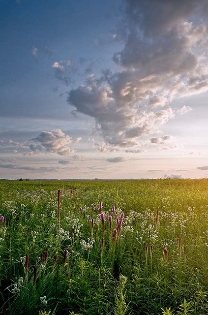
Timber, scarce as it was, provided building materials for everything from homes, farm buildings, and fences. It was the settlers’ old and familiar friend. What was new to those new prairie farmers and other settlers, and sometimes not a little intimidating, was all that prairie land stretching sometimes to the horizon like an unbroken stretch of ocean—a sea of grass.

Virtually everyone who left an account of their first few years on the Illinois prairie provided a list of superlatives. And it’s fortunate we are that some of those accounts survive to let us glimpse what those early travelers and settlers found and felt.

Harriet Martineau, in an 1833 portrait. Three years later, she left a moving description of the Illinois prairie outside Joliet.

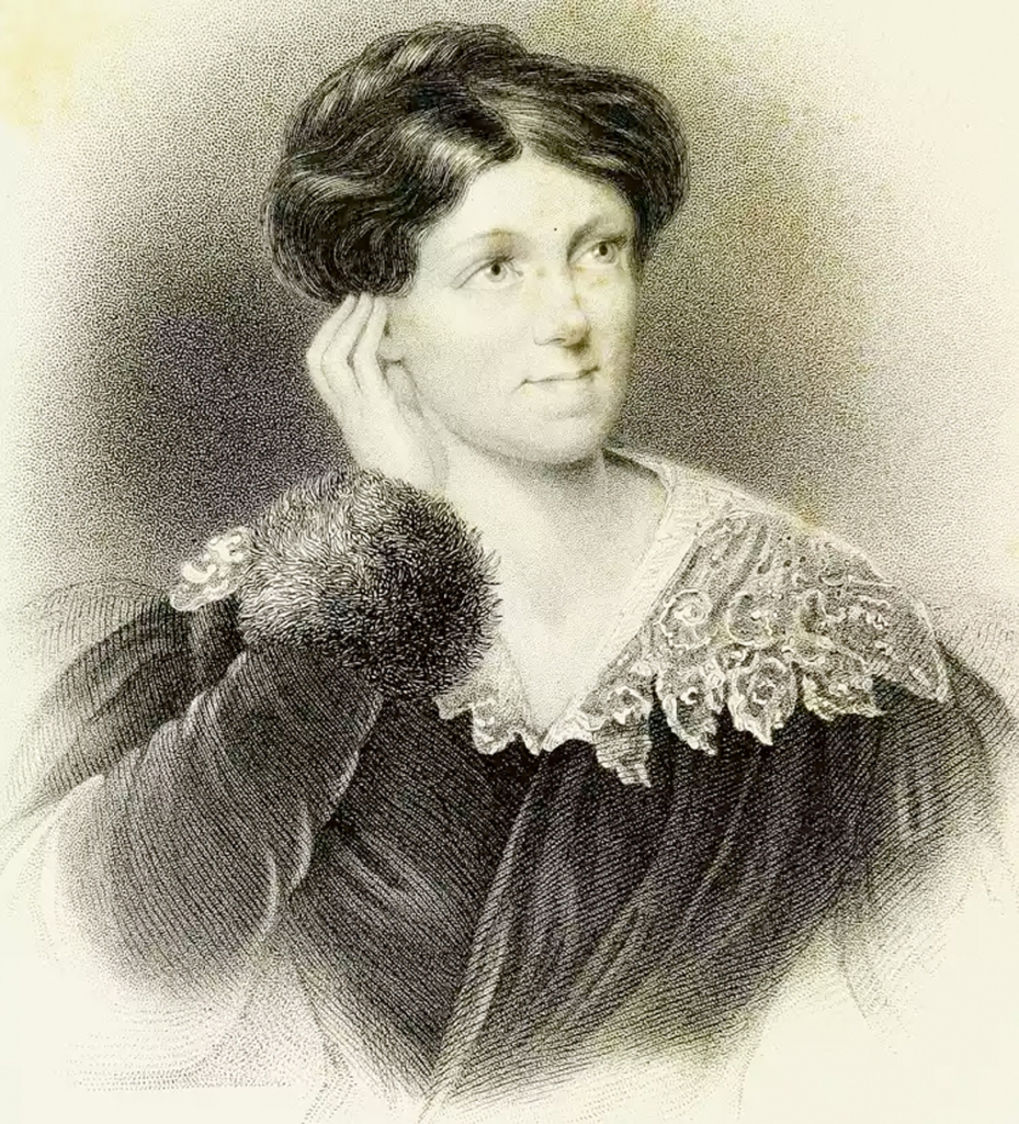
The fascinating English author, abolitionist, and sociologist Harriet Martineau, visited northern Illinois in 1836, and left a vivid record of the beauty of the Illinois prairie she saw near Joliet. She told of the beauty of the American primroses and the “…difficulty in distinguishing distances on the prairie. The feeling is quite bewildering. A man walking near looked like a Goliath a mile off.”

Her dinner one evening consisted of tea, bread, potatoes, and wild strawberries, of which a whole pail-full had been gathered around the house in which she was staying in only an hour’s time. She remarked about the beauty of the blue spiderwort in full bloom, and of prairies being “perfectly level—a treeless expanse with groves like islands in the distance, and a line of wood on the verge.”

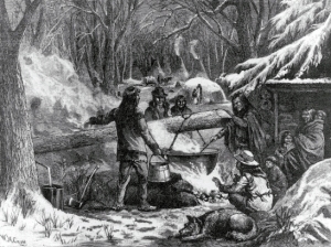
As the seasons progressed, the grasses and broad-leafed plants comprising the prairie ecology dried, providing plenty of fuel for autumn and spring prairie fires. In October 1835, Methodist circuit rider Alfred Brunsen wrote of northern Illinois prairie fires, noting that he had traveled by prairie fire light at night: “By the light of this fire we could read fine print for ½ a mile or more. And the light reflected from the cloud of smoke enlightened our road for miles after the blaze of the fire was out of sight.”

George M. Hollenback portrait from the 1914 history of Kendall County.

George Hollenback, one of the first two white children born in Kendall County (his twin sister Amelia was the other), left a description of prairie fires he recalled from his childhood. His memory of them was both exciting and alarming. He recalled seeing, as a child, as many as 50 fires burning at one time within sight of the Hollenback homestead near modern Newark in southern Kendall County, reflecting their light in the clouds on autumn evenings.

“Early settlers protected themselves by ploughing [sic] wide and numerous furrows around their fields and their stockyards,” wrote Hollenback.

Backfires were often started to protect houses and property as well as plowing furrows to create firebreaks. The band of blackened prairie grass burned in the backfire usually stopped the on-rushing prairie fire dead in its tracks.

Prairie fires like this controlled burn at the Nature Conservancy’s Nachusa Grasslands near Franklin Grove cleared out understory shrubs creating the open savanna-type groves the settlers found when they arrived. The fires were both set by natural causes–lightning strikes–or intentionally set by the area’s Native People to modify their environment.

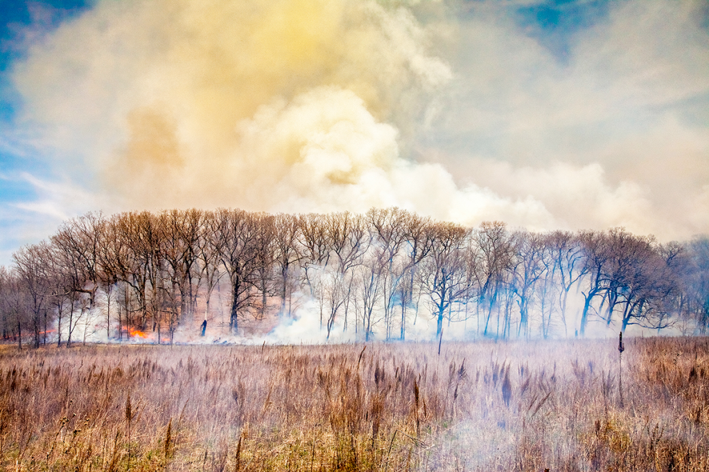
Prairie fires were usually pushed along by the prevailing winds on the Illinois prairies. That meant prairie fires most often came out of the west, and traveled eastward on the front of westerly winds. Old maps of Kendall County show that the timber on the western edge of the Fox River and the creeks in the county was much less dense that on the eastern edge, the trees on the west side thinned by the annual fires driven by those westerlies. There were generally fewer species of trees on those fire-prone western edges, too, with white and burr oaks and other more fire-resistent kinds predominating. (For a more in-depth discussion of the impact prairie fires had in Illinois, click here.)

A number of early Kendall County settlers left accounts of what Kendall County looked like when they arrived, just before settlement changed the prairies forever by converting them into farmland. Mary Elizabeth Jeneson, a member of Oswego’s Nineteenth Century Club, read a paper to the club in 1906, in which she stated: “No words of mine can convey to you the vastness, the grandeur and beauty of the natural prairie in 1850 when I first came to Oswego. The music of the big frogs down in the slough and the drumming of prairie chickens must have been heard to be appreciated. The Fox River was pretty then. Its banks furnished attractions for those who liked a stroll—a sort of Lovers’ Lane, in fact.”

Avery Beebe portrait from the 1914 history of Kendall County.

In 1914, Avery N. Beebe, an early Kendall County resident and elected official, offered his recollections of of how the area appeared to county pioneers: “This little chosen spot of God’s heritage, selected by the sturdy old pioneers of Kendall County, has been richly blessed with all the advantages that kind nature ever bestows: with its clear silvery streams, the Blackberry, the Big Rock, the Little Rock, the Aux Sable, the Waubonsia, the Rob Roy, the Clark, the Hollenback, and the Morgan, that pour their pure crystal liquids into the placid Fox and Illinois Rivers. All of these were densely skirted with abundant timbers for the use of the early settlers to construct the primitive log cabin, supply it with fuel, and establish the forest home in the wilds of the West; as it was then called.”

Change has been ongoing in northern Illinois in general and Kendall County in particular since the first pioneer wagons pulled up along the banks of the Fox River in 1828. During the last 50 years, that change accelerated as the county’s farmland—which itself replaced the stunning prairies described by the pioneers—has disappeared in job lots, with housing developments and shopping centers crowding out more and more open land. But on the positive side of the ledger, organized, serious efforts to preserve the region’s prairie past and the region’s remaining natural areas are continuing to grow.

3 Comments

Filed under Environment, Farming, Fox River, History, Illinois History, Kendall County, Local History, Native Americans, People in History, Science stuff, travel, Women's History

Timber: The indispensable resource for pioneer prairie farmers

As settlers pushed west from Ohio into western Indiana, they encountered what geographers and geologists call the Prairie Peninsula.

The peninsula was a gigantic expanse of grassland that thrust eastward across the Mississippi into western Indiana, covering most of northern and central Illinois. The expanse notable for its scarcity of timber, at least compared with the densely wooded areas the pioneers had become used to as they moved west of the Appalachians.

Unlike the shortgrass prairies found west of the Mississippi, the Prairie Peninsula was a tallgrass prairie, abounding in wild grasses and forbs (non-woody, broadleaf plants) such as Big Bluestem and Compass Plant that towered as high as eight feet above the prairie sod.

Environmental scientists still argue about exactly how and why the Prairie Peninsula came to be. But however it was formed, in the thousands of years following the retreat of the last glacier that scoured northern Illinois, a diverse and complicated ecology grew up in the Prairie Peninsula. The landscape was dominated by prairie plants, particularly grasses and sedges (which have triangular-shaped, sharp-edged stems: “Sedges have edges,” which is a handy way to differentiate them from grasses).

You can still get an idea of what the Illinois tallgrass prairie looked like during the settlement era at the Midewin National Tallgrass Prairie at Wilmington, Illinois.

Grasses such as Big Blue Stem and Little Blue Stem predominated in the tallgrass prairie, but in the spring and the fall, before and after the grasses’ and sedges’ growing season, forbs predominated, creating the brightly colored carpets of wildflowers so many of the early settlers commented on.

The settlers didn’t spend a lot of time pondering questions on how the landscape came to be, but mostly wondered how they were to survive in seemingly endless grassland with few patches of timber.

The problem was that early 19th Century settlement technology was timber-intensive, requiring lots of trees from which to manufacture split rail fences, log cabins and outbuildings, and the firewood needed to heat homes during Illinois’ fierce winters.

As the settlers pushed west out of the Ohio and Indiana timber into the prairie, they found that, in general, wooded areas followed along the banks of streams and were growing in groves in other areas of wet prairie. They quickly realized woods proved thickest on the east side of streams.

Scientists generally agree now that the prairie fires that swept across the Prairie Peninsula on a regular basis, driven by the prevailing westerly winds, were slowed or stopped by streams, which allowed more and thicker timber to thrive on streams’ east bank.

Many native prairie grasses and forbs require periodic fires to thrive, while non-native species tend to be killed by fire. In addition to high resistance to fire, most native plant species are also highly drought resistant. Prairie plants and native tree species tend to have deep root systems and leaf systems that maximize water retention. Each year, about 37 inches of rain falls here in Kendall County. Significantly, that’s almost exactly the amount of rainfall absorbed by an acre of native prairie or oak savanna.

Not only the quantity of timber was changed due to location, but the type was too. In general, fire-resistant trees such as white oak were more likely to be found along the west banks of streams, while less fire-resistant species, such as black walnut, basswood, and maples, found life easier along the streams’ west banks.

When U.S. Government surveyors arrived in northern Illinois in the late 1830s to complete the survey mandated by the Northwest Ordinance before land could be sold to pioneer settlers, they documented the types and extent of timber up and down the Fox Valley. Looking at those original survey maps and reading the surveyors’ notes, it becomes clear how important location was when it came to the kinds and amounts of the area’s timber resources.

This photograph taken by Malcom Rance at the 1911 Wheatland Plowing Match illustrates how timber-free that Will County township was even into the second decade of the 20th Century. (Little White School Museum collection)

In fact, timber-free land was settled last. Will County’s Wheatland Township, which neighbors Oswego Township to the east, was virtually treeless so when my Pennsylvania German ancestors arrived there in 1852, they were still able to buy unclaimed government land. It’s important to note that the land there, and elsewhere on treeless prairies where timber was far removed, wasn’t ignored at first because it wasn’t fertile, because it was. It was avoided for several years because vital timber was too far away.

When the earliest settlers reached the Fox Valley in the 1820s and early 1830s, they found timber edging both banks of the Fox River, although the belt along the east bank of the river was generally thicker with a more diverse species of hardwoods. In some areas, like in most of Aurora Township, just to the north of Oswego Township, there was scarcely any timber along the west bank of the river at all.

Some of these woods were, in part, densely timbered and had a hazel brush understory. But other parts of it were relatively open, what is called today an oak savanna that was fairly park-like.

In the spring and the fall, after native prairie grasses and other plants had dried out, thunderstorm lightning naturally started many swift-moving prairie fires. But in addition, in a practice that had been noted by the region’s first French explorers, the local Native American population also started fires, both intentionally and unintentionally. Unintentional fires happened when cooking fires escaped into the dry prairie. Intentional fires were much more common and were started to prepare fields for cultivation, combat insects, kill trees that were encroaching onto the prairies from the groves, and for hunting purposes. To hunt with fires, Native People would start a ring of fire sometimes a mile in diameter, and leave an unburned exit, through which game animals would be forced by the flames.

The fires also swept through the hardwood savanna areas, killing off brush and keeping the understory clear, while encouraging the growth of fire-tolerating trees and plants. Fires did a good job of creating lots of wooded edges that encouraged the deer and other animal populations.

The periodic burning, both natural and caused by man, largely created the prairie landscape found by the pioneers when they arrived. Over thousands of years, the plants and trees that grew on the prairies had come to not only tolerate, but to rely on fire. White oaks, for instance, are very fire resistant because of their thick bark and their high resistance to rotting after being scared by fire. In addition, they quickly grow after fires—fire actually helps some oak seedbeds sprout. On the other hand, many other species—maples, for instance—are very susceptible to fire damage.

While hardwood groves dotted the prairie, one extensive stretch of timber in particular caught the eye of many early mid-Fox Valley settlers.

From the location of today’s city of Batavia, all the way south to Waubonsie Creek in Oswego, a thick belt of maple, linden, oak, ash, and hickory provided an excellent source of timber, as well as protection from the prairie winds. In typical prosaic pioneer fashion, the settlers gave this huge stretch of woodland a simple and descriptive name. They called this big woods, the, well, “Big Woods.”

A detail from the 1838 U.S. Government survey map of Oswego Township shows the southernmost lobe of the Big Woods (highlighted in green) extending down the east bank of the Fox River from the Kane County line.

Not only did the settlers find welcome shelter among the hardwoods of the Big Woods, but so did the Native People who lived there before them. Chief Waubonsie, the principal war leader of the Prairie Potowatomi, located his permanent village in the western verge of the Big Woods, moving it often enough so that virtually every modern town up and down the Fox Valley from Oswego to Batavia can accurately claim to have been the site of the chief’s village at one time or another.

When the pioneers got here, they settled along the verge of the timber, locating their homes next to the woods and plowing fields in the nearby prairie. The Big Woods wasn’t regular in shape; it had many lobes that extended into the surrounding prairie, providing many protected areas where pioneers quickly established fields by plowing the native prairie with special “breaking plows,” designed to turn over the thick sod for the first time.

According to the original survey maps, the Big Woods stretched some miles east of the Fox River, almost to Naperville at the ford across the DuPage River. It then extended south all the way to Waubonsie Creek, where its southernmost lobe ended. As surveyor James Reed wrote in his notebook back on Aug. 8, 1838: “Mouth of Wabansia Creek 30 links [20 feet; a link was 7.92 inches] wide. North of creek land is timbered with white and Black oak. South of creek land is prairie and slopes gently to the river. The village of Oswego is located just below the mouth of the creek.”

The Big Woods covered almost half of Kane County’s Aurora Township, as this image of the 1838 U.S. Government survey map shows–with timbered areas highlighted in green. Note the near-total lack of timber on the west side of the river, with only a pencil-thin strip existing in the north half of the township.

The first thing the pioneers did when they arrived was start cutting down the Big Woods, along with most of the other stands of timber in the area. That initial wave of settlers was a timber-intensive bunch, requiring logs—and lots of them—to manufacture all those rail fences, build log homes and outbuildings, and supply firewood. According to James Sheldon Barber, an Oswego settler, writing back to his parents in New York State in 1843, a pioneer farm family needed 10 acres of timber to make a go of it on the Illinois frontier.

A large portion of AuSable Grove south of Oswego was subdivided into woodlots told to settlers where they could cut firewood and timber needed for building purposes. This cut is from the 1870 plat map of Kendall County.

For early arrivals, that was no problem, but they quickly claimed the timberland for their own use. Some, however, bought timber stands with the intention of dividing it into smaller parcels to sell to later arrivals. That’s why you see some wooded areas on early plat maps divided into many small chunks.

The settlers used didn’t always require cutting trees down, of course. Maple sugaring in the spring was a popular and profitable activity that even left its name behind in the name of one of our area towns—Sugar Grove. Further, the breeds of hogs the settlers brought along were hardy, ornery animals that got along just fine browsing in the oak savannas that were relatively common during those early years, especially eating all the acorns produced by native oaks.

Eventually, the only remaining woods were in wetlands and other areas not farmed for one reason or another. And, in fact, remnants still remain today, including a nice stand at Cook’s Savannah in Oswego’s Old Post Park and such areas such as Briarcliff Woods Park and the Arbor Ridge Subdivision in Montgomery and in several other areas up and down the Fox Valley. Each of those oak savanna remnants is a reminder of the landscape the pioneers encountered when they decided to settle along the banks of the Fox River.

6 Comments

Filed under Aurora, Environment, Farming, Fox River, Government, History, Illinois History, Kendall County, Local History, Native Americans, Oswego, Science stuff

It’s maple sugaring time…

Some 20 years ago, my son the Eagle Scout enjoyed helping some local folks demonstrate how maple syrup is made. He volunteered to help keep the fires burning and the sap boiling, he carried sap buckets, and he led tours and explained the process to visitors during annual weekend sugaring events.

On one of those nice spring days out at Waa Kee Sha Park, he had just explained how it took about 50 gallons of sap to produce a single gallon of maple syrup when a mom leading a small gaggle of kids raised her hand to ask, “When do you add the maple flavoring?”

To which my totally nonplussed son had no clever riposte.

We take all sorts of things for granted, not the least of which is the set of basic facts people have at their disposal. But the origin of maple syrup and maple sugar candy is one of those things that apparently not just anybody knows about. Which is a shame because that knowledge is a direct connection to our historical past. Those living history demonstrations that show how maple sap is turned into that wonderful sweet product that tastes so good on French toast help us connect to that history, and a rich one it is.

After European traders arrived on the scene and began providing iron kettles maple sugar and syrup production became a little easier. On the other hand, the effect of the European fur trade led to the destruction of Native Peoples' culture, so it wasn't all good.

After European traders arrived on the scene and began providing iron kettles maple sugar and syrup production became a little easier. On the other hand, the effect of the European fur trade led to the destruction of Native Peoples’ culture, so it wasn’t all good.

Maple sugar and syrup was a valuable food and trade item long before European settlers arrived. Native people in North America tapped maple trees, and collected and boiled maple sap into that wonderful food item using bark buckets to fill hollow log tubs, which they kept boiling by dumping in a succession of red hot rocks.

The brass and iron kettles French, Dutch, and English traders supplied in return for prime winter beaver pelts helped increase production to the extent that one eight-person group in 1764 spent a month in a sugaring camp tapping 700 trees, gathering more than 13,700 gallons of sap, and producing nearly a ton of maple sugar and 36 gallons of maple syrup.

When American settlers arrived out here in the western Great Lakes region starting in the late 1820s, they emulated the Native People’s production of maple products, tapping trees, gathering sap, and boiling it down into sugar and syrup. By that time, it was a tradition the pioneers brought with them when they left their homes in New England and the Middle Colonies and headed west to settle the Illinois prairies.

When they arrived they found numerous groves of hardwoods. On the west side of the region’s watercourses, those groves were largely comprised of Burr and White Oaks and other fire-resistant species, because the spring and autumn fires that roared across the prairies were pushed towards the east by the prevailing westerly winds tended to kill off less fire-resistant species. On the more protected east sides of watercourses, such as the Fox River, the groves were of more mixed hardwoods, with some oaks, but also of walnuts, and most importantly, sugar maples.

In those early pioneer days, maple sugar was about the only sugar available. Honey was rare until honeybees—which were not native—built up their populations. Cane sugar was extremely expensive, when it was available at all.

The surveyors who mapped the region in the late 1830s noted the prevalence of those valuable sugar maples, identifying them simply as “sugar trees.” Kendall County settlers quickly made good use of the dense stands of maples in Big Grove, Long Grove, AuSable Grove, and Specie Grove (AuSable and Specie groves are actually a single grove bisected by Morgan Creek). The spring trip to sugar camps—called sugar bushes—was an almost instant tradition.

Fires were maintained under the kettles and pans 24 hours a day as the amber syrup was boiled down from maple sap.

This painting by American artist Jonathan Eastman Johnson, titled "The Maple Sugar Camp Turning Off," illustrates the social aspect of maple sugaring in the 1870s.

This painting by American artist Jonathan Eastman Johnson, titled “The Maple Sugar Camp Turning Off,” illustrates the social aspect of maple sugaring in the 1870s.

On April 3, 1873, Kendall County Record Editor John R. Marshall wrote that: “The nice, new maple syrup left at the editor’s house last Thursday by Mr. David Kennedy was a great treat. It was clear and thick.”

It was clear county residents who had sugar bush access knew how to curry Marshall’s favor. On March 23, 1882, he observed that: “The Record boys indulged in some nice maple sugar Monday morning, direct from Deacon Sleezer’s sap-bush in Big Grove. If the ‘Boys’ have a failing for anything, it’s maple sugar.”

Long Grove was one of the closest sugar bushes to Yorkville where Marshall published the Record and kindly maple grove owners kept him in the good stuff. As he noted in the Record’s March 29, 1893 edition: “Pure maple syrup from the old Long Grove sugar camp is not bad eating with a good warm biscuit or cakes.”

By the late 1890s, cheap manufactured cane and beet sugar had become common in Kendall County households, and even maple syrup and sugar was being manufactured in huge quantities elsewhere and shipped to grocery stores here. That meant sugaring was becoming less common, although there were still some fairly big operations here where the tradition was maintained.

In March 1898, the Record’s Specie Grove correspondent waxed nostalgic concerning the maple sugaring tradition in the neighboring Specie and AuSable groves: “It’s a pretty sight to see sugar making in the ‘bush’ at night, with several fires brightly burning among the leafless trees and the weird forms of the sugar makers as they go about their work, and the surrounding darkness all combine to make the scene strangely peculiar and one to be remembered. We have often wondered if people are happier in our advanced and pampered and more genteel way of living than they were in the olden times when they lived nearer to nature and in a more simple and primitive way. We have often heard our parents and old people tell of the various kind of ‘bees’ they used to have for haying and harvesting, logging and husking, quilting and apple paring, and at sugar time and the great bake ovens and fire places that they had in York State and the East and when we see a couple of men doing all the work now on a large farm we wonder if there is much improvement as far as real happiness is concerned. Usually the most simple things contribute the greatest to our enjoyment.”

Once a common sight in Kendall County's groves, tapping sugar maples is now seen mostly during living history demonstrations.

Once a common sight in Kendall County’s groves, tapping sugar maples is now seen mostly during living history demonstrations.

Despite the economic changes, Specie and AuSable groves remained a substantial maple sugaring area for the next several years. The March 22, 1899 Record reported from Specie Grove that “A new sap evaporator has been purchased by R.G. Leitch and put on the Hall farm for the purpose of converting sap into syrup and sugar. There is a large ‘sugar bush’ on this farm and it will be developed to its fullest capacity this year,” adding two weeks later that “Four hundred maple trees have been tapped on the Evergreen Hill farm. Somebody is going to have ‘lasses.”

With those cheaper alternatives widely available, spring sugaring gradually disappeared from our region. At one time, it was such an important product, however, that the settlers actually named one area community—Sugar Grove—after that activity of “olden times.” Today, like so many of our ancestors’ activities, sugaring in the Fox Valley is mostly only visible in those living history demonstrations like the one my son participated in a couple decades ago and with a few hobbyists who like the maintain the tradition—and love the product their labor produces.

1 Comment

Filed under Farming, Food, Fur Trade, Illinois History, Kendall County, People in History