While there are lots of places on the Internet that it’s wise to avoid, there are many other sites that are well worth a visit. One of those sites that I’ve been having lots of fun with during the past several months is the “Oswego Then and Now” page on Facebook.
The site is a haven for those nostalgic for the Oswego that was, especially those who’ve moved away, as well as a fun and friendly place for current residents to reconnect with old friends, reminisce about the village’s past, and—even for us natives—learn new things about the area. It’s networking at its very best.
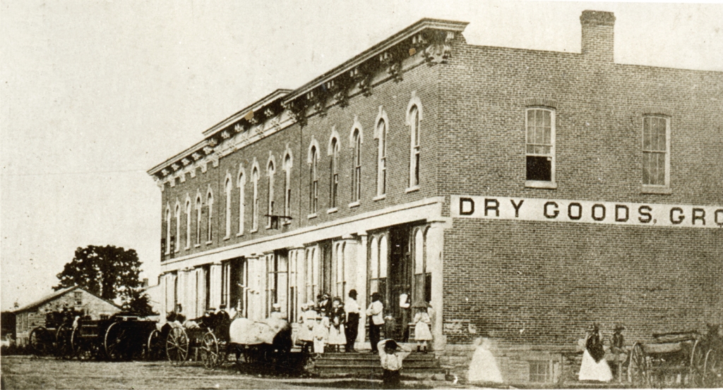
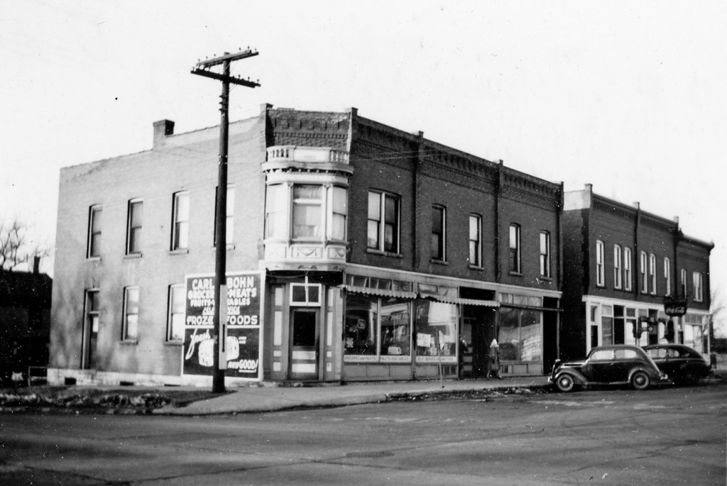
The east side of Main between Washington and Jackson streets in 1958 just as Oswego was beginning its first major growth spurt since the 1830s and changing from catering to the surrounding agricultural area to becoming an ever-expanding suburban community. (Little White School Museum collection)
A recurring theme for many posters is alarm and, often, dismay and even anger at the profound changes the community has undergone, especially during the past 60 years or so. Which is understandable, given Oswego’s population has multiplied 20 times during that period, irrevocably turning the community from the small farm town it was to the still-growing suburban community it is today.
For those of us who have continually lived in the community longer than that 50-year time period, however, the growth has definitely been surprising, but is only truly new in the shear amount of it recently.
Because Oswego, its surrounding township, and Kendall County itself actually began a radical change from its former overwhelmingly rural character to a fast-growing urbanizing area soon after World War II ended.
The era of rapid change developed due to a few factors, the first three of which, as real estate dealers always insist on putting it, were location, location, location. The city of Chicago is the engine that powers growth in northern Illinois, especially the extreme post-World War II urbanization that quickly spread to the six collar counties surrounding the city and its county of Cook.
Kendall County is the only non-Collar County that borders on three of the Collar Counties surrounding Chicago and Cook County. This made it a target for profound growth and change after World War II.
Kendall, you see, is the only non-collar county that borders three—Kane, DuPage, and Will—of those fast-growing areas.
Couple Kendall County’s location, location, location with the modernization of the region’s road system that began after World War I and the advent and perfection of economical, dependable motor vehicles from cars to buses to trucks, plus the technological agricultural advances that meant fewer farmers and less farmland were required to produce ever-increasing amounts of crops and livestock on less and less land, and you’ve created a recipe for profound change. And keep in mind that change doesn’t always lead to growth.
All it needed was a kick to get our small corner of Illinois’ growth started, and that was provided by the post-World War II economic boom of the 1950s. That was fueled by the largest governmental aid programs in history, known as the G.I. Bills. The young men and women returning home after the war were hungry to start their own families and buy their own homes. Also, many of them looked to further their educations in order to get ahead in increasingly corporate America. And the G.I. Bills funded both of those things, at least for most of those who had served.
The county’s population boom started here in northeastern Kendall County with the sprawling Boulder Hill Subdivision, a planned community fueled mainly by low-interest G.I. loans and supported by industrial expansion by giant manufacturing firms ranging from Caterpillar, Inc. to AT&T, not to mention long-established area firms from All-Steel to Equipto to Lyon Metal to Barber-Greene.
Model homes on Briarcliff Road in Boulder Hill in September 1958 appealed to those eligible for G.I. Loans, with no money down and low interest rates. (Photo by Bev Skaggs in the collections of the Little White School Museum)
That first tranche of growth from the mid-1950s through the 1970s created the first major change as the Oswego area saw itself change from dependent on providing agricultural support services to becoming a bedroom community, the vast majority of whose residents had no connection with farming at all. Instead, they commuted not just out of Oswego but also north and east out of Kendall County to staff the Fox Valley’s surging industrial base.
And that was about the time I got into the local journalism business, first as a historical columnist for the old Fox Valley Sentinel and then in 1980 becoming the editor of the Ledger-Sentinel after the Sentinel and Oswego Ledger merged.
In fact, the single biggest news story we covered for the next several decades after the Ledger-Sentinel was established was growth and the profound changes it wrought in Oswego and the rest of Kendall County and the Fox Valley.
My interest in how local history dovetailed with what was happening in the rest of North America and the world gave me, I think, a useful perspective on what was happening here in the Fox Valley.
Change, it was clear, was the most important governing historical factor and had been for centuries. The cultures of the region’s indigenous people had constantly undergone change since they had arrived as the last Ice Age ended. Their descendants, then, were forcibly displaced by the White descendants of European colonists who had arrived on the Atlantic coast in the 16th, 17th and 18th centuries.
In the Treaty of Chicago, signed in 1833, the indegenous people of northern Illinois signed away the rest of their rights to their lands. It would lead, in three years, to the tribes being forced to remove west of the Mississippi River to secure the region for White settlement. (“The Last Council of the Pottawatomies, 1833,” by Lawrence C. Earle, 1902)
Illinois’ inclusion in the new United States was partially confirmed as the result of the Revolutionary War, and was finally assured by the treaty ending the War of 1812. The various wars with the region’s indigenous people that finally ended in northern Illinois in 1832 resulted in their forcible expulsion to areas west of the Mississippi River. And that, in turn, opened the region to the flood of White settlement that forever changed the area’s very landscape.
The U.S. Civil War of the 1860s also had a profound effect on the Fox Valley. Even though fighting took place hundreds of miles away, nearly 10 percent of the county’s entire population served, and more than 200 died. The end of the war saw Kendall County’s population steadily decline during the next century due to a number of factors. Among those factors was the 1862 Homestead Act that used the lure of free land to persuade farmers to head west to try their luck on the trans-Mississippi shortgrass prairies.
Not until the next historical inflection point was reached after World War II did the character of the county and, especially, our corner of it begin to profoundly change once again.
Downtown Oswego immediately after World War II, where businesses primarily catered to the surrounding agricultural area was about to begin an era of change that is still taking place today. (Little White School Museum collection)
And so here we find ourselves looking back on what proved to be a period of extraordinary, sometimes chaotic social, economic, and population change as what so many of us remember as the unchanging halcyon days of our youth. Because Oswego’s always been a great place for kids to grow up; it’s still one of the safest towns in Illinois. And besides, when we were kids, our parents were the ones who did the worrying.
These days, Oswego’s Little White School Museum has become the main repository where as many pieces of the area’s history and heritage as possible are being collected, safely stored, and interpreted before they’re lost forever. The collection keeps growing as us volunteers frantically work to save as much Oswego history as we can before it’s either paved over or pitched into a Dumpster.
So with those aims in view, at noon this coming Saturday, May 4, the museum—located at 72 Polk Street in Oswego—will host another program dedicated to chronicling some of that disappearing history. As its title suggests, “Lost Oswego” will be look at the community landmarks that have been lost through the years, losses that in many cases are far from recent. In addition, the program will recount some of the community’s public and private preservation successes that are helping remind us of the Oswego area’s rich history and heritage.
The program’s sponsored by the museum and the Oswegoland Heritage Association. Admission will be $5, with proceeds going to benefit the museum’s operations. Reservations can be made by calling the Oswegoland Park District at 630-554-1010 or visiting the museum program page at bit.ly/LWSMPrograms—or you can walk in on Saturday and pay at the door.
I was working on the “Lost Oswego” presentation I’m scheduled to give on Saturday, May 4, at the Little White School Museum here in Oswego when I decided to include a few architectural preservation successes the community has enjoyed.
The program is mostly about the landmarks we’ve lost over the years, a process of change that began a few decades after Oswego was founded and continues to the present day. But Oswego’s architectural history isn’t all bleak; there have been a few major successes, too. Chief among those, of course, is the Little White School Museum itself. Slated for demolition in the 1970s, a grassroots community effort not only saved the landmark structure, but led to its complete restoration into the community resource and treasure it is today.
Oswego’s landmark Little White School Museum is a notable Oswego preservation success. Photo by Stephanie Stekl Just.
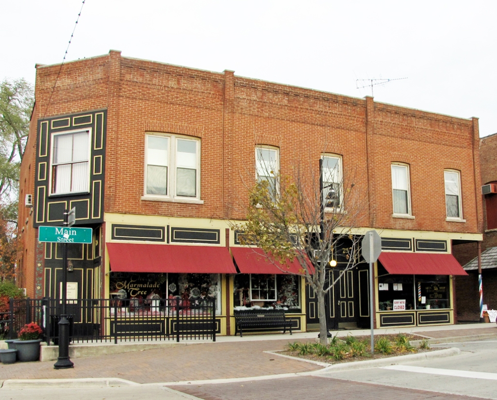
While the Little White School Museum success was due to a private-public partnership between the not-for-profit Oswegoland Heritage Association and the Oswegoland Park District, some other Oswego landmarks have been saved by their private owners. A group of three adjoining buildings on the west side of Main Street just north of Jackson Street is a prime example of that.
Originally three separate buildings, the W.O. Parke Building, the first Oswego Community Bank, and the Durand House have been turned into a single commercial structure that enjoys a lot of community patronage.
William Oscar Parke built his two-story front-gabled landmark commercial building of native limestone in 1845 at the northwest corner of Main and Jackson streets.
The W.O. Parke building (center) as it looked about 1876. (Little White School Museum collection)
Like all of Oswego’s limestone buildings, the stone was likely quarried right in the Oswego area, which boasted a number of limestone quarries. One quarry was right behind what’s now the Oswego Public Library along Waubonsie Creek and it’s likely that’s where the stone for Parke’s building came from. Other limestone quarries were located east of the modern Ill. Route 25 bridge across Waubonsie Creek and operated by early settler Walter Loucks and on either side of Wolf’s Crossing Road just east of the original Oswego village limits, operated by Elijah Hopkins. Yet another quarry, this one specializing in flagstone of varying thicknesses, was operated by George D. Wormley on the west bank of the Fox River a couple miles upstream from Oswego. After its life as a stone quarry, the Wormley quarry property was sold to the YWCA for use as a summer camp and named Camp Quarryledge. Since those days, the parcel has had numerous owners but the old quarry, namesake of the camp, still exists.
Fred (left at wheel) and Claire Willis with their new REO Speed Wagon at their Oswego Tin Shop in the Parke Building about 1904. Note the parging is still attached to the building. (Little White School Museum collection)
In addition, the Parke Building was also parged. Parging consists of covering a building’s stone or wood siding with a relatively thin layer of mortar. While the mortar’s still wet, the mason doing the parging work scribes lines in it making it look as if the building is constructed of cut stone rather than the random-layed stone we see today when the parging has all fallen off or been otherwise removed.
Parke, a businessman and Oswego’s second postmaster, ran both his store and the post office from the building. After Parke sold the building in 1848 a number of postmasters and merchants conducted business there ranging from grocery stores, harness shops, a tinsmiths, and an auto repairs. The Oswego Post Office remained housed in the building, off and on, from the 1840s until Postmaster Lorenzo Rank moved it to the new building he erected in the middle of the block between Washington and Jackson streets in 1874.
Rank, who was also the long-time Oswego correspondent for the Kendall County Record and knowing community residents would probably complain about the change, wryly noted in the Record’s Aug. 4, 1874 “Oswego” news column: “The post office has been moved from the corner where it was in operation for about 19 years to the center of the block across the street. The inside arrangements of the new office are about as crooked as they could have been made. The change is not favorably regarded by the public.”
Oswego Postmaster Lorenzo Rank moved the Oswego Post Office from the Parke Building to his new post office in 1874. (Little White School Museum collection)
As Rank explained about Parke in the Aug. 5, 1875 Record: “W.O. Parke, or Oscar Parke as familiarly known, was in an early day one of the most energetic men and prominent merchants of this town; he was the postmaster during the administration of James K. Polk and again during a portion of that of Franklin Pierce. Intelligence of his death was received a few days ago.”
Over the next several decades, the building went through several owners and just as many uses, from a grocery store to a feed mill to a harness shop. In 1901, Oswego jeweler A.P. Werve moved his jewelry store into the ground floor of the building, while he and his family lived upstairs. Werve also bought a couple pool tables in 1902 to supplement his store. And in January 1904, Werve opened a bowling alley in the building as well. Werve was apparently quite an innovator—he custom built the first automobile in Oswego in 1903.
After Werve’s numerous uses the building was purchased by Gus Shoger and rented out for a number of uses including farm implement sales. In Sept. 1914, Fred and Clare Willis displaced the harness business in the building and moved their tinsmithing and heating business there, where they remained until Clare was called up to serve in World War I.
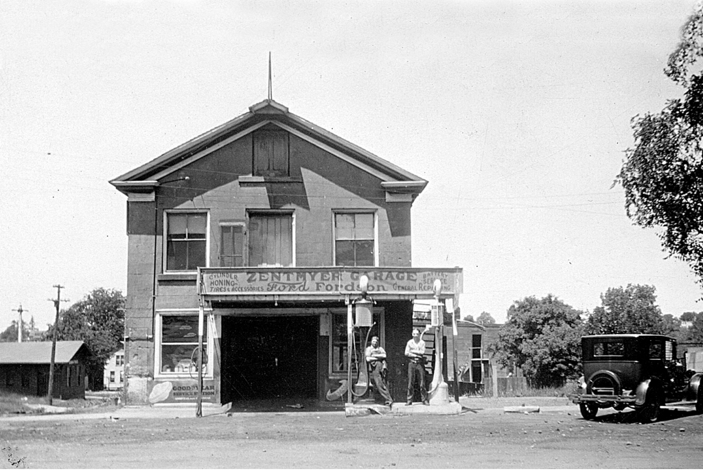
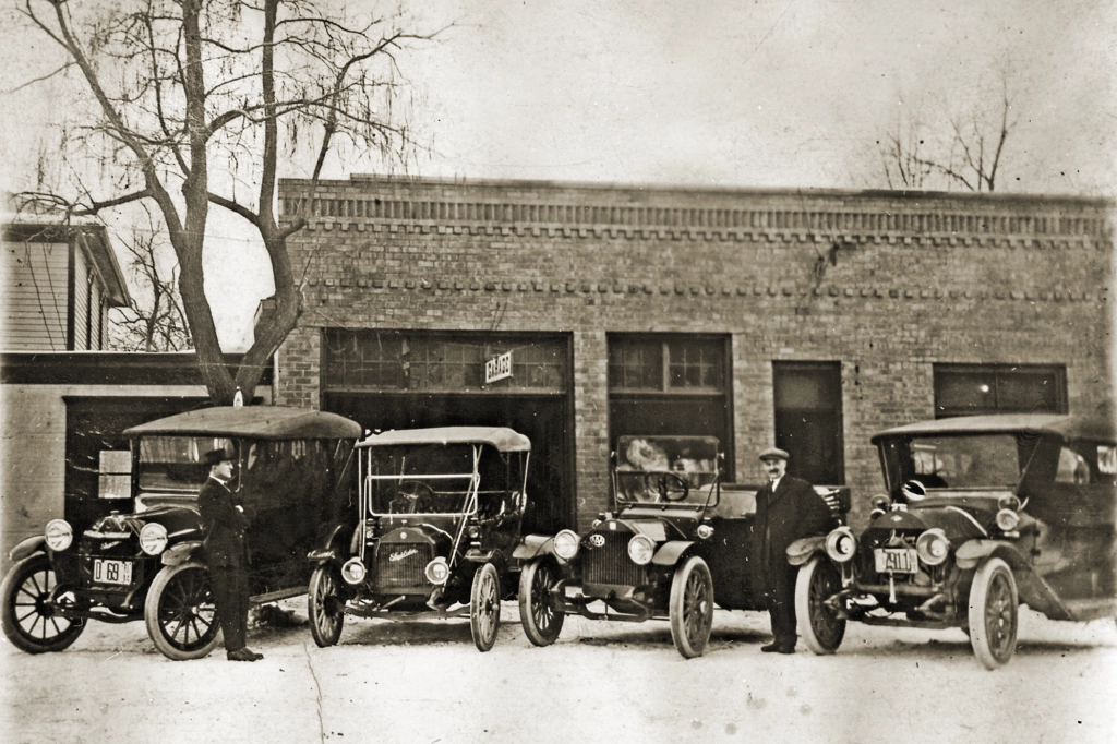
The W.O. Parke Building about 1927 after Earl Zentmyer moved down from Aurora and bought the old Liberty Garage that Charles Reid ran. Note the parging is still almost completely intact and that the business included gasoline pumps. (Little White School Museum collection)
Then in 1922, young Earl Zentmyer came down to Oswego from Aurora looking for an opportunity to open an auto repair business. As it happened, Charles Reid, who was operating the Liberty Garage in Gus Shoger’s stone building, was looking to sell. Shoger offered Zentmyer good rental terms and the deal was sealed. Zentmyer opened the village’s first Ford auto dealership there in 1929. In the early 1930s, he bought the stone building as well as the old livery stable across Main Street at the northeast corner of Main and Jackson, moving the dealership there after doing some extensive remodeling.
Lay-Z-Pines Driftwood Arts occupied the W.O. Parke Building in 1958. Earl Zentmyer still owned the building at the time. Note the Durand House next door with the vacant area between the two buildings. Photo by Homer Durand in the collections of the Little White School Museum.
Zentmyer continued to own the building, where a number of businesses from his son, Jim’s, post World War II appliance store to the first Rucks Appliance Store to Zentmyer’s wife’s Lay-Z-Pines Driftwood Arts gift and craft store were located.
Zentmyer owned the building until 1970, when he sold it to Jacqueline and Ken Pickerill. The Pickerills had moved their Jacqueline Shop, an upscale women’s apparel store, there from their original location on South Main Street in 1960. In 1996, the Pickerills retired and sold the building to Greg Kaleel, who today houses the Prom Shoppe women’s clothing store in the historic structure, continuing a 170 year mercantile tradition.
As far as I can determine, no structure ever bordered the stone Parke Building to the north during the 19th Century, other than a storage shed or two. Instead, a single-family home was built a short distance north, leaving a blank space.
In 1863, James A. Durand and his family moved to Oswego from their former home at the end of modern Light Road There, Durand had been the CB&Q’s first Oswego station agent, and bought what became known as the Durand House at 19 Main Street, just a short distance north of the Parke Building.
After they left Oswego in 1869, the house was rented to many Oswegoans including pioneer druggist Levi Hall and his new bride.
Oswegoan John Sanders served in the Mexican-American War in 1846. He eventually returned to Oswego and married the widow, Nancy Pearce King. The couple moved about the U.S. fairly often as Sanders engaged in businesses ranging from sliversmithing to retail merchant. They permanently returned to Oswego and bought the Durand house in 1873. Sanders progressively lost his eyesight during the next several years until he was totally blind. He died Feb. 12, 1885 and is buried in the Pearce Cemetery.
The Village Grind as depicted on the Oswegoland Heritage Association’s 2015 Cat’s Meow architectural miniature fundraiser.
During the next 106 years, the house experienced many owners and residents before 1991 when Lee and Bernie Moe opened the Village Grind Coffee & Tea Company, Oswego’s first dedicated gourmet coffee shop. The Moes sold the business to its current owners, Jodi and Dave Behrens, in 2004. Today, the Village Grind, which has been amalgamated into a block of storefronts with it and the Parke Building being sort of bookends, remains one of historic downtown Oswego’s most popular destinations.
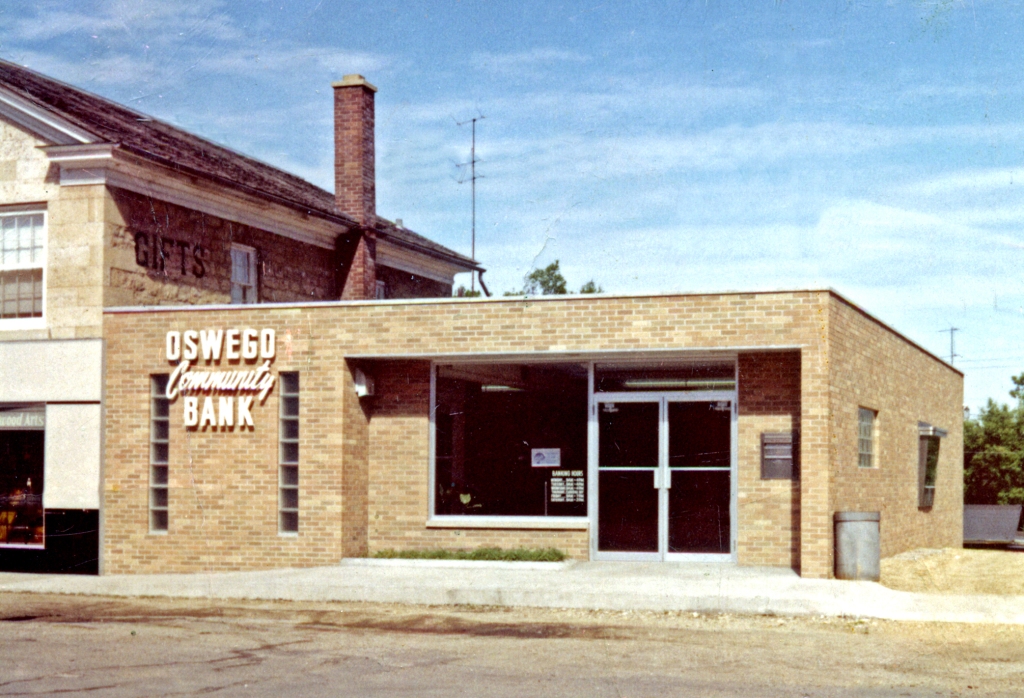
And then there’s the building in the middle that offers a connection between the Parke and Durand buildings, the first Oswego Community Bank.
Banks in Oswego didn’t have a very successful history. The community’s first, a private bank, was established by Oswego druggist Levi Hall. As the Kendall County Record reported on Feb. 24, 1881: “It should have been mentioned heretofore that Oswego has made another progressive step and reached a very important business acquisition namely that of a bank. L.N. Hall in connection with his [drug] store is now doing a general banking business, and he has the best facilities for conducting it.” Hall’s store was located in the north storefront of the Union Block on the east side of Main Street between Washington and Jackson streets.
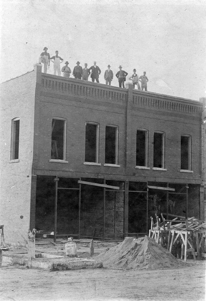
Oswego Community Bank under construction, June 11 1958 on Main Street just north of Jackson. Dick Young, contractor, is working on the rear wall in this photo by Homer Durand. (Little White School Museum collection)
Unfortunately, Hall became a victim of the Panic of 1893, one of the nation’s periodic economic depressions. The Panic was so serious that all three Kendall County banks failed during a two-week period that summer. Hall, an honest and contentious businessman, worked hard to try to pay back his depositors. The community didn’t get another bank until 1903 when the Oswego Banking Company opened. Eventually bought by the Burkhart family and turned into the Oswego State Bank, it failed during the Great Depression of the 1930s.
After that, it took the community nearly 30 years before they were ready to try establishing their own bank again. But local businessmen and farmers finally realized they really need a local bank. On Nov. 22, 1956, Oswego Ledger Editor Ford Lippold noted: “There is some talk about the possibility of a bank being formed in the village. This is one of the things that will be of great benefit to everyone in the community.” He followed up with this Dec. 13 note: “A public meeting is being planned for Jan. 14, 1957 to discuss the possibility of setting up a bank in Oswego, a facility that really is needed.”
The gathering turned out to be successful, Lippold reporting on Jan. 17: “A good group of Oswegoans turned out for the meeting in the Community Room Monday night to discuss the possible formation of a bank in Oswego. There was a general feeling in the group of a definite need for a bank in Oswego and a steering committee is being formed to lay the groundwork for the possible organization of a bank on a community basis.”
The small but tidy interior of the Oswego Community Bank when it opened in downtown Oswego in 1958. (Little White School Museum collection)
Talks with potential corresponding banks and attorneys continued and on April 4, 1957, the Ledger reported: “G.C. Bartholomew, chairman of the organizing committee for the new Oswego bank reports that the number of necessary forms pertaining to the organization of the bank have been completed by the following organizers: Homer Brown, Dr. Sheldon Bell, John Cherry, Charles Lippincott, Myron Wormley, Earl Zentmyer and G.C. Bartholomew.”
The idea was for the new institution to be a true community bank, Lippold noting in the April 25 Ledger that “Present plans are to have the shares of stock in the new bank sell at a low cost each so that everyone will have an opportunity to be a part of the new organization. A limit will be placed on the amount of stock that any one person can own.”
From there, plans moved forward quickly with tens of thousands of dollars being subscribed in the proposed bank by Oswego residents. Lippold was somewhat surprised at the positive attitude of so much of the community towards the new bank given the normal negativity towards just about anything new, noting on Oct. 10, 1957: “It’s been a long time since there’s been so much interest in anything in the community as there is in the new Oswego Community Bank and, for a change, the comments are mostly favorable. Oh, there are a few diehards who say it will never go, but they are the same ones who said the auto would never replace the horse. Back to the easy chairs, boys, lay down and roll over, you’re dead.”
The Oswego Community Bank shortly after it opened in August 1958 at its original Main Street location, sharing its south wall with the W.O. Parke Building’s north wall. Note the unfinished drive for the drive-up window at right. (Little White School Museum collection)
On March 13, 1958 the Ledger reported that Oswego contractor Richard Young had broken ground on March 9 for the new bank building on Main Street just north of Jackson Street, adjacent to the Parke Building. It was hoped construction would be completed in 120 days, according to bank officials. In addition, seven local residents were elected to the bank’s first board of directors including George. C. Bartholomew, John Cherry, Myron Wormley, Sheldon Bell, Charles Lippincott, Earl J. Zentmyer, and Homer Brown.
As planned, the new 1,700 square foot building included a first floor plus a full basement. The vault, with a capacity of 1,050 safe deposit boxes, was built of 18″ thick steel reinforced concrete.
The bank opened on Aug. 30, 1958, the Ledger reporting: “Among the many features offered in this well-planned, air conditioned building are a modern vault ample teller facilities, safety deposit boxes, drive-up window, safety alarm system, day and night depository, and a customer parking lot. A spacious basement area is available for employees’ comfort and for future expansion as the Oswegoland community continues to grow.”
The W.O. Parke Building after it became the home of the up-scale women’s clothing store, the Jacqueline Shop. This photo was taken in the early 1980s after the Oswego Community Bank had moved out and Jacquie and Ken Pickerill expanded into that space. The mansard canopy across the front was added in the mid-1970s. (Little White School Museum collection)
Wrote Lippold in an Aug. 28 Ledger editorial: “The opening of the doors of the new Oswego community Bank Saturday morning, Aug. 30, is another omen of the future of the Oswegoland community. A year ago, the bank was only an idea in a few people’s minds. Today, it is proof that 242 Oswegoland folks have faith in their community and are willing to back up this faith with cold, hard cash.”
“It is also a good sign that the opening comes almost at the same time as our mammoth 125th anniversary Oswegorama celebration,” he continued. “With a solid past of a century and a quarter, the future can hold nothing but god for the people of the Oswegoland area.”
Tiny by modern banking standards, the new bank served the Oswego community for the next 13 years, but by the late 1960s it was clear the little community institution had run out of room. Through the cooperation of the Oswego School District, Oswego Township, and the Village of Oswego, four lots on the block bounded by Jackson, Monroe, Jefferson, and Madison streets—the old Red Brick School site—were rezoned, paving the way for a new bank on the corner of Madison (U.S. Route 34) and Jackson streets.
The W.O. Parke, Bank, and Durand House buildings as they appear today as they look after owner Greg Kaleel tied all three together in 2011 with a brick-cladding theme. The Parke Building is 179 years old. (Little White School Museum collection)
Ground was broken in late June 1970 for the new structure and the move from the downtown bank to the new building was completed under heavy police guard in late May 1971. Subsequently, the old bank building was sold to Ken and Jackie Pickerill, owners of the adjacent Jacqueline Shop women’s clothing store. The store quickly expanded into the bank building.
After Greg Kaleel bought the Parke and bank buildings, as well as the Durand House, he connected all three buildings creating a single commercial block to serve customers from those seeking good food at the Village Grind in the Durant House to fine clothing in the rest of the building—one more piece of Oswego’s rich downtown architectural history.
Oswego’s grown a LOT during the past several years, to the point that unincorporated Boulder Hill, once several times larger than the village, can now perhaps be considered a sort of suburb. But the time was, more than a century and a half ago, Oswego actually did have a suburb, and an industrial suburb of sorts at that, bordering the village to the north.
The Fox River Valley’s pioneer millwrights, who provided some of the most vital services early pioneers required, followed closely behind the area’s first settlers. Early millers used their talents to provide food by grinding corn and wheat into flour, and also supplied building materials from their first rudimentary saw mills on the Fox River as well as on its tributary creeks.
The official U.S. Government map drawn from the 1838 survey of the area shows tiny Oswego at the Fox River’s narrows and Levi Gorton’s gristmill–noted as a “flouring mill” in the surveyor’s notes–at the dam just upstream from the village.
In 1836, Merritt Clark arrived in the Oswego area—the tiny village tumbling along the brow of the ridge overlooking the Fox River was then called Hudson—and built what Kendall County’s first historian called a corn mill on the west bank of the river. The mill was located about 3/4 miles north of the village that had been laid out in 1834 by Lewis B. Judson and Levi Arnold. Judson and Arnold called their new community Hudson—probably to remind them of their home area of New York—but it was renamed Oswego in 1837 after Congress awarded the growing town its own post office.
The same year Oswego got its post office, Levi Gorton and William Wormley built a dam across the Fox River to provide water power for Clark’s mill, and Clark reportedly added a chair factory to his corn milling operation. Later that same year, however, Clark apparently sold his business, including the mill and dam, to Levi Gorton and his brother, Darwin. The Gortons, apparently unsatisfied with Clark’s rudimentary mill, started construction that year of a true grist mill on the same site. The new mill was ready for operation the following year.
Then sometime prior to 1840, the Gortons sold their mill and dam to local business and property owner Nathaniel A. Rising. Rising and his partner, John Robinson, added a store to the grist mill at the west end of the dam and continued and apparently increased the business the Gortons had founded.
Nathaniel Rising and Zelolus Bell’s plat of the new town they proposed to call Troy was filed at the Kendall County Courthouse in Oswego in 1848. Located just north of the existing Village of Oswego, the new community was proposed as an industrial suburb. (Little White School Museum collection)
In 1848, apparently looking for even more opportunities, Rising and Zelolus E. Bell, who was then acting on behalf of the estate of the now-deceased Robinson, laid out the Town of Troy on a site located at the east end of the mill dam. The official plat of the new village was recorded on June 24, 1848 at the Kendall County Courthouse, then located in Oswego. County voters had agreed to relocate the county seat from Yorkville to Oswego in 1845.
Rising and Bell located Troy just far enough north of Oswego that the boundaries of the two towns never really touched each other, even after Walter Loucks’ addition to Oswego was platted sometime after 1860.
This 1870 map shows the relative locations of Troy and Oswego, located about 3/4 of a mile apart along the east bank of the Fox River. The map’s interesting not only for its Oswego and Troy illustration but also the limestone quarries in and around Oswego it shows, along with John Steiner’s ill-fated brewery midway between Oswego and Troy. (Little White School Museum collection)
As laid out, Troy was bounded by Summit Street (now Ill. Route 25 and North Madison Street) to the east and the Fox River to the west. As originally numbered, the village consisted of Blocks 5, 6, 7, 9, 10, 18, 19, 20, and 21. Blocks 1–4 were apparently never platted, perhaps being saved for future expansion.
Full blocks measured 280.5’ (17 rods) square and were divided into eight lots bisected by two 16.5’ wide alleys running at right angles. As it turned out, only Blocks 9 and 7 were fully lotted, with Block 10 consisting only of Lots 1 and 8; Block 6 remaining totally unlotted; Block 5 containing Lots 1, 2, 3, and 4; Block 21 containing Lots 1 and 2; Block 20 containing only Lots 1, 2, 3,and 4; Block 19 containing Lots 1 and 2 (each as large as two regular lots; and Block 18 containing Lots 1, 2, and 3.
Water Street (now North Adams Street) divided Blocks 5, 6, 7, 9, and 10 from the riverfront Blocks of 18, 19, 20, and 21.
Connecting Summit Street with the Fox River were (from north to south) First Street, Second Street, and Main Street. Third Street connected Summit Street with Water Street but apparently did not go all the way through to the riverbank as did the other streets.
As platted, and just like the lots in the Village of Oswego, each standard lot was 66’ (four rods) wide by 132’ (eight rods) deep.
Exceptions were the riverfront lots, which varied considerably in depth, and Lots 1 and 8 in Block 10. Lot 1 was 132 feet deep but was only 53.5 feet wide at its west end, narrowing to just 40 feet of frontage on Summit Street. Lot 8 was 66 feet wide on Water Street, but narrowed to 55.5 feet on the alley at its east border. Exactly why this was remains one of local history’s mysteries.
Streets platted by Rising and Bell varied in width from 60 to 70 feet. As platted First, Second, and Third streets were 60 feet wide, while Main and Water streets were 70 feet in width.
Besides laying out the village of Troy, Rising and the Robinson estate also added a sawmill at the east end of their dam to compliment the gristmill at the west end of the dam. It was located on Lots 1 and 2 of Block 19 in Troy.
In 1852, Rising sold the mills, dam, store and all other parts of Troy that remained unsold to William O. Parker. Parker had been born in Canada in 1828 and moved to Illinois with his family in 1836. In 1851, Parker moved to Oswego, purchasing the Rising milling operation and the rest of Troy just a year later. And with the sale, the milling operations on both sides of the river became collectively known locally as Parker’s Mills.
Five years later, in February of 1857, an exceptionally severe spring freshet—flood—occurred and destroyed Parker’s east bank sawmill and the dam, and damaged the grist mill on the west bank. Although Parker suffered damages of $3,000, a considerable sum in 1857, especially since a devastating financial depression was about to hit, he rebuilt the sawmill and dam and repaired the gristmill and store. And his businesses continued to thrive, serving the area for decades thereafter.
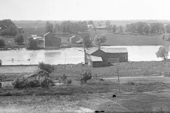
The Parker Gristmill (left) on the west bank of the Fox River ground farmers’ grain, while the Parker Sawmill and Furniture Factory (foreground, right), located in the old Village of Troy, sawed lumber and made furniture. Both mill sites are now parks in the Oswegoland Park District system. (Little White School Museum collection).
Then in October 1870, the Ottawa, Oswego & Fox River Valley Railroad reached Troy and Oswego, sparking a business boom. According to contemporary maps, the railroad right-of-way passed through Troy along the north-south alley splitting Blocks 7, 9, and 10.
But the arrival of the railroad probably also spelled the eventual doom of Parker’s milling operations. With the railroad providing cheap, all-weather transportation for flour and lumber coming in and farmers’ crops and livestock going out, water-powered mills up and down the Fox River Valley began closing down.
A walnut washstand manufactured at the Parker Furniture Factory in Troy is on exhibit at Oswego’s Little White School Museum. (Little White School Museum collection)
Perhaps not realizing what was about to happen, about 1870, possibly prompted by the arrival of rail transportation to get products to market, Parker added a furniture factory to his sawmill. The factory manufactured a number of items including chairs and other furniture made from the area’s extensive supply of black walnut trees. A solid walnut washstand could be purchased, unfinished, from Parker’s factory for less than $1. An example of one such Parker washstand is on display in the gallery at the Little White School Museum in Oswego.
Another person who profited off the railroad’s arrival was my great-great-grandmother, Mary Ann Minnich. She and her husband had moved into one of the houses in Troy about 1867, and she apparently figured renting sleeping space to railroad workers would be a good money-maker as construction went through Troy and Oswego.
The workers were a fractious lot, however, as the Kendall CountyRecord reported on July 14, 1870 while the line was still under construction: “Some excitement prevailed here last evening among the railroad laborers owing to a report that they would not get full pay for labor performed; a party started for headquarters (Ottawa) in consequence of it; [John W.] Chapman went with them; pretty much all the male population of the “Patch” [Troy] was in town.”
The next week, on July 28, the Record reported: “A number of suits for riot, assault and battery, breaking of the peace &c., has been commenced before both Justice Fowler and Burr by the belligerents of “the Patch,” [Troy] which by agreement were all merged into one and tried Wednesday and Thursday of last week. Smith was the attorney for Gaughan. Hawley and Judge Parks of Aurora for Monaughon & Co. John Monaughon and Michael Ruddy were held to bail to keep the peace and appear at the next session of the circuit court.”
The drama in Troy didn’t end there, either. Far from it, in fact. Just a few weeks later love in Troy was in the news. The Record reported on Sept. 1, 1870: “For once, there is a first class item, an elopement. One evening the latter part of last week, Pat Monaughon, a boy of 19 years of age eloped with Mrs. Dowling and her three children; Mr. Dowling, the lady’s husband, was absent from home; both parties were residents of the Patch [Troy].”
In 1847, Truman Mudget built the first brewery in Kendall County about where the railroad tracks would pass along Adams Street to the west of downtown Oswego. But, as the Rev. E.W. Hicks commented in his 1877 Kendall County history, “the soil was not congenial, and it ran only a few seasons.”
The Fox River Creamery located on Ill. Route 25 just north of North Street and east of North Adams Street. (Aurora Historical Society photo)
But in 1857 local beer enthusiasts decided to try again, building a native limestone brewery along Summit Street on land just north of Oswego’s village limits. This brewery was more successful, but even though the new rail line passed close by, the brewery failed. In 1877, William H. McConnell purchased the defunct brewery, remodeled it, and reopened it as the Fox River Creamery.
“Milk instead of barley, and butter instead of beer,” Hicks, a Baptist minister, wrote approvingly, adding: “And both cows and men are the gainers.”
Although the creamery, which produced cream, butter, and cheese from local farmers’ milk, was not officially part of Troy, lying in that sort of no-man’s-land between Troy and Oswego, it was close enough as made little difference.
Also drawn by the railroad, the Esch Brothers began their Troy ice harvesting and sales business in Troy. They located their huge ice houses just north of Parker’s dam on the east bank of the river, north of Second Street in Troy. The company harvested ice from the mill pond behind Parker’s dam each winter and used the sawdust from the saw mill to insulate the ice in the huge houses. As the Record reported on Nov. 18, 1874: “The ice procurable in the mill pond is to be exported hereafter; an ice house 102 by 60 feet is now being constructed near there, or on The Patch, as the place [Troy] is usually called, by Rabe & Esch, Chicago firm.”
Esch Brothers & Rabe’s 20 huge ice storage houses just above the dam at the old Village of Troy just above Oswego. Note the piles of sawdust used to insulate layers of the 200-pound blocks of ice cut from the river during the winter. (Little White School Museum collection)
On Nov. 28, 1878, the Record’s Oswego correspondent reported that the ice company was expanding its operations: “Troy, our suburb, has been growing much faster than Oswego the past year; ten new buildings 100×50 have been erected there by Esch Brothers, and Co.; they being ice houses; the whole number now being 14.”
Also from May of 1878 through May of 1879, McConnell, using the new railroad, was able to ship 177,000 lbs. of butter and 354,000 lbs. of cheese from the Fox River Creamery, most of it going to Chicago hotels.
In January of 1879, the Kendall County Record reported the Esch Brother were employing 75 men in the ice harvest. It was big business. In August of 1880, Esch Brothers shipped 124 rail cars of ice from the firm’s Troy siding.
1880, in fact, seems to have been the economic high point of Troy. That year, the Esch Brothers added a 35 horsepower steam engine and an endless chain (conveyor system) to move ice from the river to the houses during harvest and from the houses to the rail cars on the firm’s siding for shipment. William Parker and Sons made a number of improvements at their mills as well that year. An addition was built to the furniture factory adjacent to the saw mill and another story was added to the mill itself. And finally, the ice company built their own buildings to house both the men and the horses used in each winter’s ice harvest. As the Record’s Oswego correspondent put it on Dec. 9, 1880: “The boarding house, a two story, and the stable constructed by Esch Bros. & Rabe [in Troy] for the accommodation of the men and horses necessary for the ice harvest are completed and doubtless the operation of cutting and storing the ice will commence immediately.”
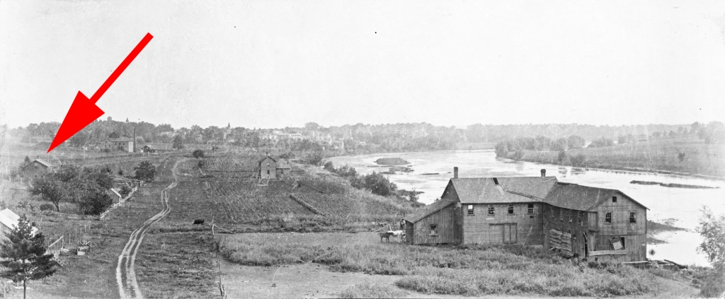
A view of Troy, probably in the late 1890s. The photo was likely taken by Irvin Haines from the roof of one of Esch Brothers & Rabe’s ice houses looking south towards Oswego. Water Street–now North Adams Street–is a dirt track that snakes along between fence rows at left. The Parker Sawmill and Furniture Factory is at right, the sawmill parallel to the river and the newer furniture factory perpendicular to the river. The red arrow marks Mrs. Minnich’s house, where she rented sleeping space to railroad and ice company workers. (Little White School Museum collection)
Troy’s reputation as a lively spot continued along with its economic growth. On Aug. 18, 1881, the Record reported from Oswego: “Saturday evening a dispute arose between Henry Sanders, who had been drinking, and Cash Mullenix, and it is alleged that in order to emphasize his points, the former exhibited a pistol which caused his arrest and lodgement in the town house; during the night somebody released him by breaking out a part of a window and cutting open the door of the cell. The authorities seemed to be aware that he had gone to Mrs. Minich’s [sic] house and about 10 o’clock Sunday a posse went there and upon their approach Henry left the house and ran to the river, and a few steps into it where the water was shallow but then surrendered.”
By 1883, the Oswego Ice Company, owned by the Esch Brothers, had 25 ice houses in operation, including six new houses measuring 150’x180’. During the yearly winter ice harvest, the company housed 1,000 tons of ice daily. As part of the growing number of improvements, the company was connected by telephone to the Oswego Depot of the Chicago, Burlington & Quincy Railroad to coordinate dropping off and picking up cars on the firm’s rail siding.
But in 1891, a disastrous fire struck the ice company, and before the flames were extinguished, 14 giant ice houses were destroyed and their contents ruined. The fire took place in March at the conclusion of the annual ice harvest. The company never recovered, and was–literally–liquidated.
The Parker Gristmill being dismantled about 1927. Its timbers and stonework were used to rebuild the old Seely stone barn at the west end of the Oswego bridge into Turtle Rock Inn for Mr. and Mrs. James Curry. The Currys moved into Turtle Rock in November 1928. (Little White School Museum collection)
By the turn of the century, both the grist and saw mills were no longer in operation. According to some accounts, the saw mill burned prior to 1908. The grist mill was dismantled in the 1920s by local carpenter Irvin Haines, and the wood beams and stone were used to help build Turtle Rock Inn at the west end of the Oswego Bridge.
Another try at establishing an ice company was made shortly after the turn of the century. The Knickerbocker Ice Company, Inc. purchased several lots in Blocks 20, 21, and 6 in early 1909. However, as far as is known, no ice was harvested by the firm as the dam was then in extremely poor shape and the millpond badly silted up. Besides, by that time, the Fox River was badly polluted and manufactured ice was quickly replacing the old “natural” ice. No additional ice houses were built by the Knickerbocker company, and the corporation sold all its land in Troy to Central Trust of New York in 1911.
Over the years, several of Troy’s streets and alleys have been officially been vacated. All of First Street is vacated, as is the portion of Water Street (North Adams) north of Second Street. Main Street from Summit Street to North Adams was vacated, with the vacation recorded on Nov. 4, 1967, as were the alleys in blocks 7 and 9. Third Street from Summit to Water has also been vacated.
The portions of Second and Main streets from North Adams to the Fox River, however, have never been vacated, nor has the alley between lots 2 and 3 in Block 18.
The site of the Parker saw mill and furniture factory along the east bank of the Fox River in the old Village of Troy, is now named Troy Park and is owned and operated by the Oswegoland Park District. It offers picnicking and fishing from the ruins of the old sawmill mill foundation. Across the river, the site of the old grist mill is now Millstone Park, also owned and maintained by the park district.
And finally, residents living in the old Village of Troy, as well as those in nearby Cedar Glen and a few other surrounding properties, voted to annex to the Village of Oswego in the late 1980s. On Dec. 5, 1988, the Oswego Village Board voted unanimously to annex its old industrial suburb of Troy, ending a long, interesting era in local history.
On a cold February night in 1867, an overheated stove pipe in an Oswego store started a destructive fire that destroyed virtually every building on the east side of Main Street between Washington and Jefferson streets in the village’s downtown business district.
The blaze was considered one more severe blow to the community, which had sustained a severe economic disappointment three years earlier when the county seat was finally moved from Oswego to the new courthouse in Yorkville.
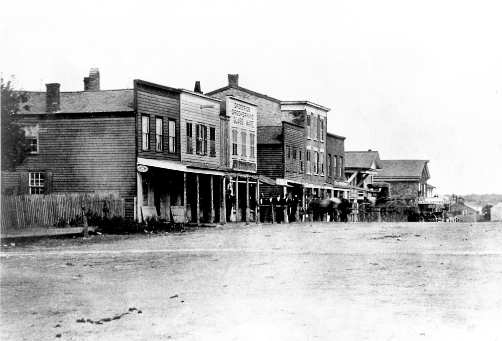
Although of poor quality, this is the only known photo of the east side of Oswego’s Main Street business district before the devastating 1867 fire. The white-columned landmark National Hotel is at left. (Little White School Museum collection)
But although they didn’t realize it in the immediate aftermath of the fire, what Providence accomplished that night would turn out to be in the best long-term interests of the town. A century or so later, what happened that night would be termed urban renewal as modern brick commercial buildings replaced existing old timber framed store buildings, some dating nearly to Oswego’s founding in the mid-1830s.
The new brick Union Block as it looked in 1870 after the cornices were added to the roofline of the buildings to enhance the structures’ Italianate architecture. Note the National Hotel lot is still vacant. (Little White School Museum collection)
During the next year, the “Union Block” rose on the ashes of the most of the buildings that burned, although the half of the block north of the alley that bisected it that had been occupied by the stately National Hotel would remain vacant for several more years.
The evolution of commercial buildings in downtown Oswego was chronicled in a series of photographs taken over the span of several years. Those images give us a look at the broad outlines of the way commercial architecture in small Illinois towns changed with building technology over the years. Many other small towns mirrored Oswego’s experience across the nation, including most of those right here in Kendall County.
The original buildings that went up in Oswego’s downtown were virtually identical to those built during the same era up and down the Fox River Valley. Using the abundant timber growing along both sides of the river, early merchants built timber framed stores and other commercial buildings. In the 1850s, with the invention of balloon framing—similar, but not identical, to the technique used to build homes today—some of the older timber framed buildings were moved out of the downtown to be replaced by newer structures.
For instance, the village’s first store, established about 1835 by Levi F. Arnold in the middle of what is today the downtown business district, was eventually moved near a home in the village where it soldiered on as a barn for many more years.
Oswego’s first store, built by one of the village’s founders, Levi F. Arnold, was moved from downtown when a new, larger structure was built to replace it. It soldiered on for years as an in-town barn. (Little White School Museum collection)
The stores built during that era were of the old style shops with small sash windows. Window-shopping during that era was virtually unknown; customers went to shops where they knew what goods were available and bought what they needed.
But by the 1860s, a retail revolution had already taken place, led by such visionaries as Alexander Turney Stewart. Stewart built his eight-story Cast Iron Palace in New York to market a huge variety of goods to the city’s residents, rich and not rich alike. The new use of cast iron framing allowed soaring windows and airy interiors. . The size of the windows was limited in width, but not in length after a process was invented to produce what was called cylinder glass that produced long, narrow sheets of glass. The tall windows allowed much more natural light into the buildings’ interiors than the old double-hung sashes, dramatically brightening the interiors and making them much more inviting for customers.
This portrait of the Funk & Schultz grocery store and meat market from about 1904 nicely illustrates the narrow, tall 1867-era windows in the store’s decorative cast iron front. The store, located in the brick Union Block on the east side of Main was eventually ‘modernized’ along with the other storefronts in the block of commercial buildings. (Little White School Museum collection)
The new buildings in downtown Oswego were designed in the then-fashionable Italianate architectural style using decorative cast iron fronts of the kind pioneered by Stewart that sported tall, narrow windows to let in light as well as to entice customers with the goods they could see from the street.
The west side of Main Street looking north from Washington Street about 1870 resembled a western cow town with it’s false-front buildings. All of the buildings in the photo were eventually demolished except the A.O. Parke Building–now The Prom Shoppe–at right. (Little White School Museum collection)
Although the east side of Main Street got its forced architectural facelift in 1867, throughout the rest of the 19th Century, the west side of Main Street was still dotted with old small-windowed frame buildings from the 1840s and 1850s. Then in the 1890s, things took a dramatic change in direction.
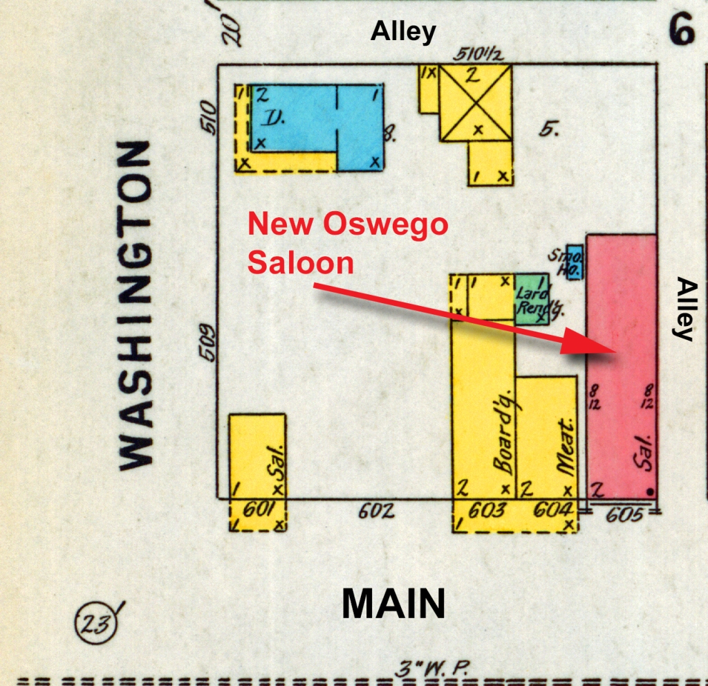
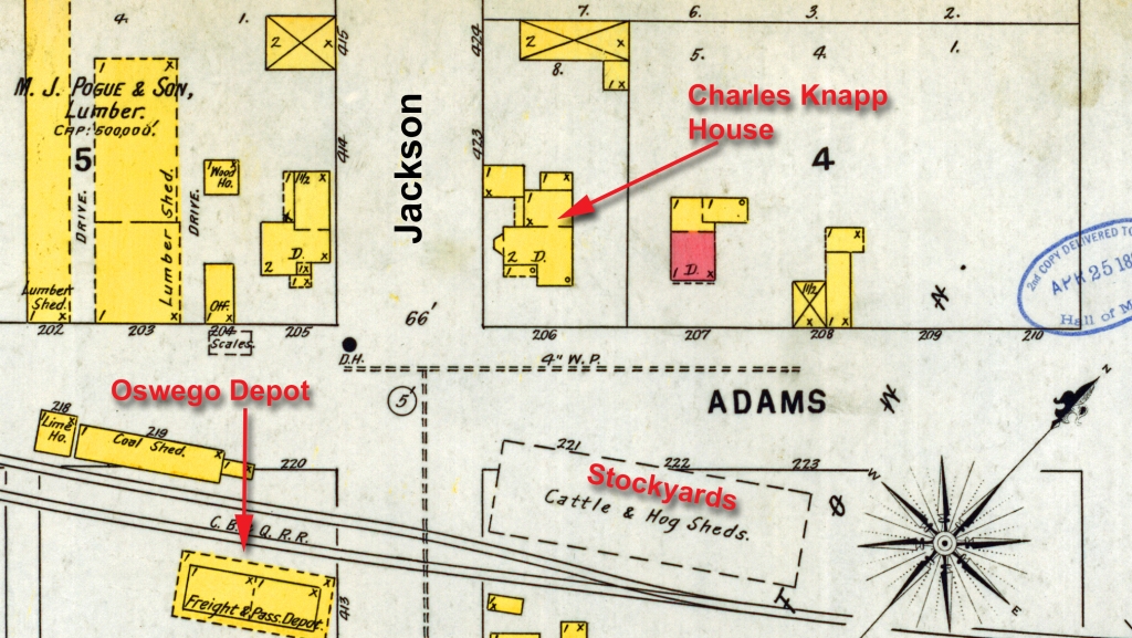
The Knapp Building under construction early in 1898 on the west side of Main Street opposite the Union Block. Like its neighbor next door to the north–the Oswego Saloon, built the year before–the Knapp Building featured large plate glass windows. (Little White School Museum collection)
The first of the modern all-brick buildings on the west side of Main between Jackson and Washington Street in the heart of Oswego’s downtown, was the ornate Oswego Saloon. Begun in the autumn of 1897 on the west side lot bordering the mid-block alley to the south, it was designed by its owners to be an architectural marvel. Reported the Kendall County Record’s Oswego correspondent on Nov. 3: “The new brick building, which is to be built of the most modern style of architecture and finish, will be the pride of the town. We folks who have been in the habit of saying that “saloons are no good” will have to dry up. The building is about ready for the roof.”
It made use of improvements in commercial building technologies—including glassmaking—that had been developed during the three decades since the Union Block had been built. As the Record reported on Dec. 22: “The large plate-glass was put in place in the new saloon building and the steel ceiling overhead has been put on by John Edwards.”
Then in 1898, Oswego businessman and livestock dealer Charles Knapp built his two storefront brick commercial building adjoining the Oswego Saloon to the south. The Record reported on April 20: “ The work on the Knapp new buildings is going forward very rapidly. The laying of the brick is expertly and expeditiously done. A few fair days would reach the putting on of the roof.” Like the Oswego Saloon, the Knapp Building was two storeys, with the second floor proposed for use either as apartments or a hotel.
By June 22, the Record’s Oswego correspondent could report: “The Knapp buildings are nearly completed and now receiving the finishing touches. The metallic ceiling of the hall and rooms connected with it are made dazzling by paint.”
The building’s first tenants were the Croushorn furniture store and funeral parlor and Knapp’s own meat market.
Then, finally, in 1899, Oswego businessman John Schickler built his new brick three storefront building at the northwest corner of Main and Washington across from the 1867 brick Union Block. Like the Oswego Saloon and the Knapp Building, Schickler’s two-storey building featured ornate cast iron fronts with much wider plate glass windows.
These new “show windows” (the term was an American invention) turned the buildings themselves into advertising media, keeping the goods—and the customers—inside on permanent display.
This 1904 photograph nicely illustrates the larger plate glass display windows the new (left to right) Schickler, Knapp, and Oswego Saloon buildings boasted on the west side of Main Street in downtown Oswego. All three structures were built in the then-popular Eastlake Style architecture. (Little White School Museum collection)
One-story buildings, primarily the all-brick Burkhart Block diagonally across the Main and Washington Street intersection from Schickler’s building following Schickler’s architectural lead were later built on South Main Street.
The next downtown building featuring then-new state-of-the-art commercial architecture wasn’t built until more than a half-century had passed. In 1954, Bohn’s Super Market rose at 60 Main Street on part of the east side site once occupied by the old National Hotel. A classic 1950s era commercial structure, Bohn’s had aisles wide enough to accommodate shopping carts. While self-service (“cash and carry”) was encouraged, Bohn’s still accommodated residents who called in their grocery orders and expected delivery.
Like commercial buildings in Kendall County’s other small towns, other retail innovations such as elevators were unnecessary, although downtowns in the larger nearby communities of Joliet and Aurora made full use of them and others, from chain stores to public transportation. But the economic impact of new commercial buildings making use of the technology available at the time had major impacts on the communities in which they were built, no matter how small.
Kendall County towns where growth continued in the late 1800s and early and mid 1900s all eventually sported buildings like those built in Oswego. Looking at commercial architectural styles in Yorkville, Plano, and Sandwich is a good way to tell when growth took place. Although most of the graceful old narrow-windowed cast iron front buildings have had their facades “modernized,” the discerning enthusiast can still track the evolution of commercial architecture in local towns. And as new growth begins to accelerate in the face of ever-increasing development, those remnants of the county’s commercial past provide a link with the area’s fast-disappearing history.
Between 1840 and 1858 seven of the nine living children of Johann Leonhard Burkhart immigrated to the United States from Birkach, Bavaria
Initially settling in and near Little Falls, New York, the first to arrive, Johann’s daughter, Margaret, met and married John Hem, a farmer and stonemason. From there, Barbara and John sent money back to Bavaria to, one-by-one, bring six of her siblings across the Atlantic to join her.
Not finding New York to their liking, however, the growing German immigrant extended family looked west to Illinois where they heard rich land was available at affordable prices. So during the winter of 1843-44, a 12-member family group of Hems, Burkharts, Haags, and Fausts headed west to Chicago.
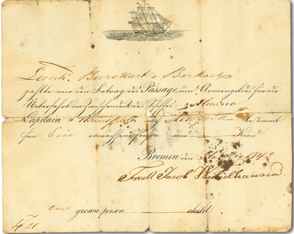
Georg Leonhard Burkhart’s 1843 sailing ticket to the U.S. English translation: Leonhard Burkhart, Birkach has paid the fare for passage and accompanying baggage in the middle deck on the ocean crossing aboard the ship Alwina under Captain Krensfeld for New York only for one adult and child [with space for number of accompanying child/ children lined through] Bremen, May 31, 1843. Fried. Jacob Hichelhausen. (Little White School Museum collection)
Fast-growing, boisterous, muddy, swampy Chicago was definitely not what these immigrant German farmers were looking for, so they moved farther west, arriving in Kendall County’s Oswego Township in 1844. The families chose to claim land east of the growing village of Oswego along what is now known as Wolf’s Crossing Road on what was known locally as the Oswego Prairie. The Hems started with an 80-acre farm.
George Leonard and Anna Margaret Brunnemeyer Burkhart. (Little White School Museum collection)
Margaret’s younger brother, Georg Leonhard Burkhart—who quickly shortened his name to Leonard—soon bought his own 80-acre farm bordering the Hems’ to the north. Marrying Anna Margaret Brunnemeyer on Christmas Day, 1848 in Naperville, the young couple set out farming and raising a family. They were extraordinarily successful at both, being able to eventually gifting each of their eight children with their own farms or the monetary equivalent on their wedding days.
Their son, Leonard Frederick Burkhart, born on the family farm in 1859, but apparently grew up looking to be something more than just a farmer like the rest of his siblings. In 1881, he married Otilda Philopena Lang. Like Leonard’s parents, the couple turned their energy towards farming and building a family—but only briefly.
Because, as it turned out, Leonard Fred (as he was known), despite the farming that had been in their parents’ blood for generations, would also figure prominently in Oswego’s in-town business community, including giving the family name to one of Oswego’s most familiar commercial buildings.
Leonard Frederick and Otilda’s son, Oliver Andrew Burkhart, read law, became an attorney, was elected Kendall County State’s Attorney and was a federal court commissioner, as well as being the long-time Oswego Village Attorney. Along with that, he also invested in Oswego’s business community and became an early adopter of automotive technology—he was one of Oswego’s first automobile dealers.
The Oswego Banking Company was established in the south storefront of the Schickler Block in 1904. (Little White School Museum collection)
Then in 1904, F.H. Earl and D.M. Jay of Plano announced plans to open a bank in Oswego. E.W. Bowman of the Bowman Bank in Kalamazoo, Michigan was also interested in the new firm, named the Oswego Banking Company. Floyd Phelps was hired to run the enterprise, which located in the Schickler Building at the northwest corner of Main and Washington streets in Oswego.
The new bank opened in January 1904.
During the summer of that same year, Leonard Fred Burkhart acquired the private bank, and installed his son, Oliver A. Burkhart as the banker replacing Phelps.
But the space in the Schickler building was limited and Leonard Fred had his eye on the lot kitty-corner from the bank’s location.
In January 1908, he bought what was known as “the Smith Corner” at the southeast corner of the Main and Washington intersection with the intent to build a new brick block to house the family’s bank as well as other businesses.
The storey and a half frame building that occupied the site was a venerable old structure dating back several decades. But to make room for his new commercial block, the old had to go.
To make way for his new brick commercial block, Leonard Fred Burkhart had to clear the corner site. By the time construction began only the Greek Revival frame building at the corner was still standing. (Little White School Museum collection)
As the Kendall County Record reported from Oswego on April 1, 1908: “Oswego village is to have a new bank and office building. It will be a brick block, situated on the corner where the electric cars turn to cross the trestle on the site formerly occupied by the waiting station. The old building has been torn down and with its razing one of the oldest landmarks of the village passes away. The new structure is being built by L.F. Burkhart, the Oswego banker; and the bank will be located in it, and the rest of the building will consist of offices for the professional men of Oswego.”
With construction underway, Leonard Fred began casting about for tenants, and instantly found one in his son, Oliver’s auto dealership partnership with his cousin, Charles Shoger. The pair had been selling autos to Oswego residents for some years, eventually dealing in cars manufactured by E.M.F., the Flanders (eventually bought out by Studebaker), Jackson, Empire, Olds, Carter, and Studebaker. A set of gasoline pumps was also considered for the future.
The completed Burkhart Block housed (left to right) the Burkhart & Shoger Garage, the Oswego State Bank, the Oswego Post Office, and the Oswego telephone exchange. This photo of the building was taken about 1913 by Dwight Young. Little White School Museum collection)
But with the auto dealership facing Washington Street and his bank in the corner suite with its unique corner doorway, Burkhart needed more businesses to fill out the block’s two storefronts that would face South Main Street. In business, timing is often the most crucial factor leading to success, and that was certainly the case with Burkhart’s new building.
The Burkhart & Shoger Garage, owned by Oliver A. Burkhart (left) and Charles Shoger (right) on Washington Street just east of Main, in 1914. Burkhart and Shoger were dealers for EMF and Studebaker autos with four new ones parked in front in this photo. Little White School Museum collection)
The Oswego Post Office, which had been located in the false-front frame building across the alley from the Union Block on the east side of Main Street since the 1870s, was becoming cramped and the postmaster was looking for a new home, one that Burkhart was happy to offer to him.
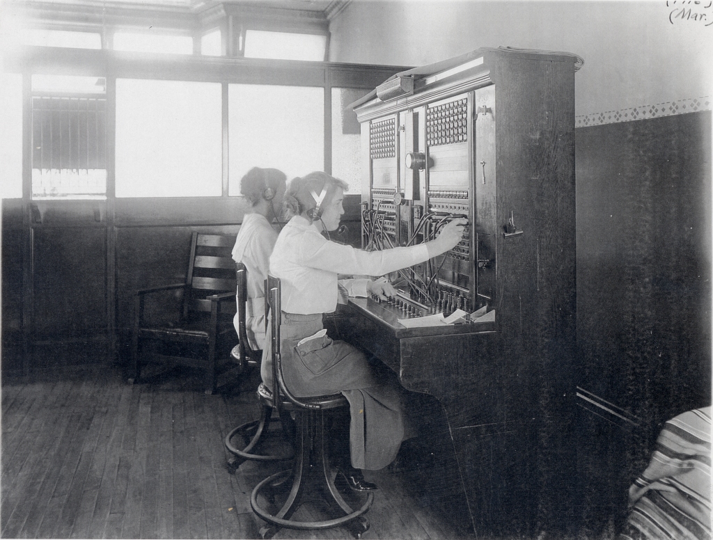
The Chicago Telephone Company’s new switchboard in the Burkhart Block in March 1911. Above, Orma Young Shoger connects a caller while Ina Huntoon handles other calls. (Little White School Museum collection)
Further, the Chicago Telephone Company’s Oswego switchboard (later Illinois Bell Telephone) had outgrown its home on the second floor above Cutter’s Drug Store and was looking for a new, larger, location. Burkhart suggested he had just the spot for them, and they quickly took him up on the idea.
By the end of January 1912, all the businesses had moved into the new Burkhart Block, where they were all slated to remain for the next several decades—with a few changes.
Oliver’s brother, Clinton, joined the banking business early on, and continued as the bank president for many years. He was also elected Oswego Village President for several terms. He continued with the bank until it closed due to the combined effects of the Great Depression and a daring 1932 daylight robbery. After the Oswego State Bank was forced to close, Oswego didn’t become home to another bank until the Oswego Community Bank was established in 1958.
Interior shot of the Oswego State Bank, probably taken in 1913 shortly after it opened at the corner of Main and Washington streets. (Mark Harrington collection)
In 1925, Oliver Burkhart’s younger brother, Ralph M. “Burkie” Burkhart, bought the car business, renaming it the R.M. Burkhart Garage. He became a Pontiac dealer in 1934 and operated the business there until he retired in 1971, selling the business to Jim Detzler, who maintained the “Ugly Little Showroom” until moving out of downtown to larger quarters at Zero Boulder Hill Pass. When Detzler assumed ownership of the dealership, it was the first time since the Burkhart Block was built that a Burkhart wasn’t involved in a business located in it.
The Oswego Post Office continued in the Burkhart Block until the Postmaster George Bartholomew decided to move it to larger quarters in the Schickler Block across the intersection due to the community’s accelerating population growth. The facility moved in late March 1958 and remained there for a decade until Oswego’s “new” post office—the current, badly cramped facility at Madison and Jackson—opened in 1969.
Burkhart’s Garage, with gas pumps, during World War II in 1942. (Little White School Museum collection)
And while Illinois Bell’s old Oswego switchboard was replaced by automatic dial equipment in 1939, the storefront they occupied in 1911 continued to be their Oswego home until 1969 when the new automated switching station opened at Washington Street and Ill. Route 71. In 1971, the new facility allowed Illinois Bell’s Oswego customers to be the first in Illinois to receive speed dialing, conference calling, call forwarding, and call waiting services.
The Burkhart Block, with businesses (left to right) Burkhart Pontiac, the Kopper Kettle, the Jacqueline Shop, and Illinois Bell Telephone’s switching station. Photo by Homer Durand in the collections of the Little White School Museum.
With the departure of its core occupants, the Burkhart Block became the home of many other enterprises over the years. For instance, the old post office storefront became the location of the first Jacqueline Shop women’s clothing store when Jackie and Ken Pickerill opened it in 1957. The upscale store moved to the historic A.O. Parke Building at Main and Jackson in 1960.
Other businesses in the Burkhart Block have ranged through the years from the Kopper Kettle restaurant to the Elmer Fudge candy store to the Booze Bin liquor store. Today, the building is still a popular location for a variety of retail businesses.
Several years ago while doing family history research, I made connections with a distant cousin who sent me a compact disc (remember those?) with dozens of photos and documents related to my Minnich ancestors. Among the documents were letters written by my great-great-grandmother, Mary Ann Wolf “Polly” Minnich, to her daughter, who was then living out in Kansas.
Mary Ann Wolf “Polly” Minnich from what was probably her 1846 wedding portrait.
The letters were remarkable for a few reasons, not the least of which was because Mary Ann was illiterate. According to the letters’ content, she dictated them to one of her grandchildren, who wrote and mailed them for her and who would then also read the replies to her. Another interesting point, for me, at least, was that at the time she was corresponding with her daughter, she was living in the ramshackle old house on North Adams Street in Oswego that was the first house my wife and I bought back in 1968.
The previous owners were the first non-family members to have owned it since my great-great grandparents owned it in the 1870s. We lived there for about 10 years, and so I was familiar with its interior layout. My grandmother, who as a child had visited HER grandmother at the house told us about the interior changes that had been made, including turning my great-great grandparents’ tiny first-floor bedroom into the home’s bathroom. Which is why the bathroom had a full-sized window in it above the bathtub that looked out onto North Adams Street and the east bank of the Fox River across the road.
The Minnich House as it looked in 1970 with Mary Ann’s bedroom window facing North Adams Street and the Fox River circled in red.
By the time we moved in back in ’68, trees lined both banks of the river, cutting off the view of Route 31 over on the river’s west side. But back when my great-great-grandparents lived there, the original old-growth trees on both banks had been cut down years before to provide everything from fence rails to firewood to building materials for homes and other buildings the pioneers needed. So someone looking out of the window in our bathroom—formerly my great-great-grandparents’ tiny bedroom—could easily have seen traffic over on Route 31, known back in the late 19th and early 20th centuries as the West River Road.
Which is a long, but I think necessary set-up for a fascinating comment I found in one of those letters long ago transcribed from my great-great-grandmother’s dictation.
North Adams Street about 1910 with the arrow pointing out my great-great-grandparents’ house, and illustrating the treeless banks of the Fox River during that era. The building at right foreground is the Parker Sawmill and Furniture Factory. (Photo by Irvin Haines in the collections of the Little White School Museum)
By late September 1900 residents living in and around Oswego, including those living along North Adams Street, had some new sights to see and marvel at. As my great-great-grandmother put it in one of those letters to her daughter out in Kansas: “When I can’t sleep at night I can watch the Street cars run out my window over across the river.”
She could see the headlights of streetcars running on the west bank of the Fox River in 1900? Yes, as it turns out, there was, indeed, a trolley car line that ran from Aurora south roughly following the Fox River to Oswego that began service that year.
This contemporary map illustrates the route of the interurban trolley line from downtown Aurora south through Oswego into downtown Yorkville where it terminated at Van Emmon and Bridge streets. (Little White School Museum collection)
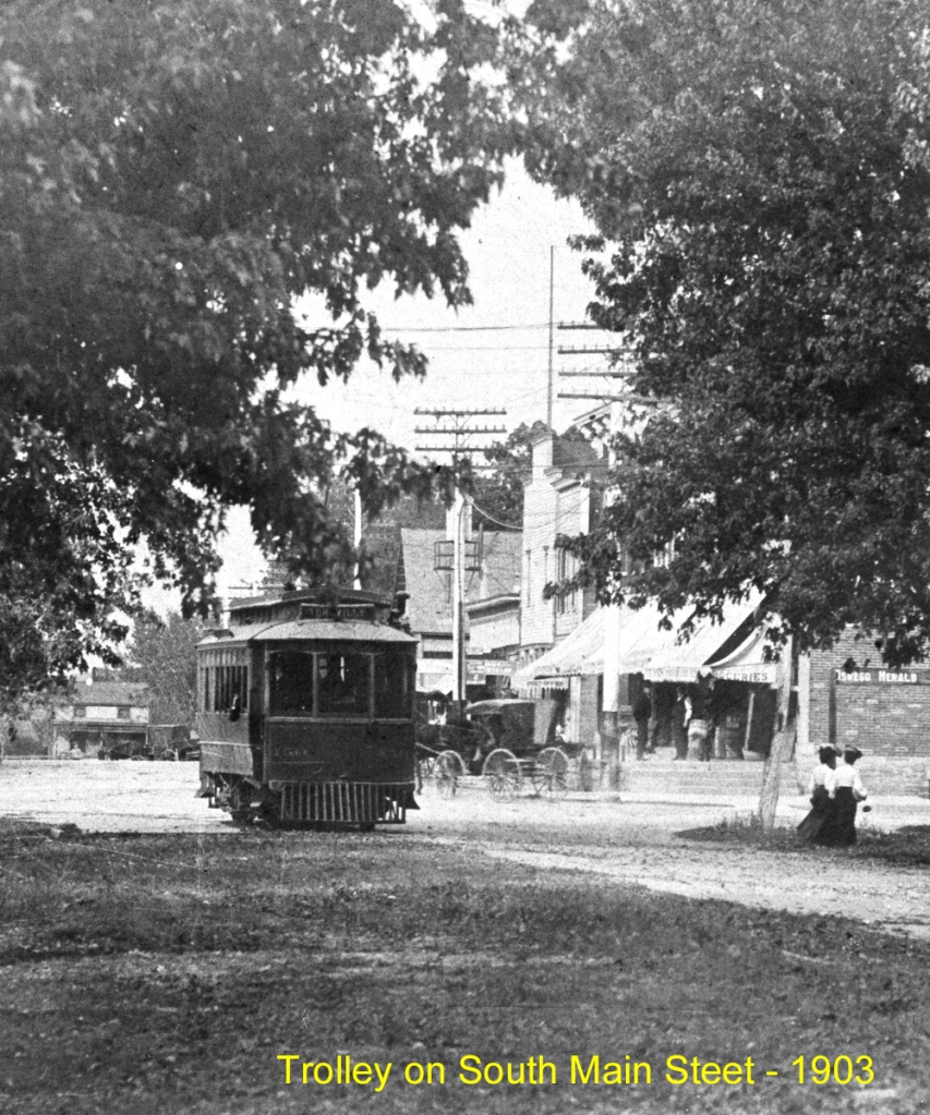
Because this kind of trolley line ran between towns and not wholly inside them, the lines were called “interurban” trolleys, and were at the height of their popularity as the 20th Century dawned.
A group of investors first proposed building an interurban trolley line from Aurora south through Montgomery and Oswego to Yorkville in 1897. The proposed line was planned to run mostly on public street and highway rights-of-way using light rails and electrically-powered trolley cars.
First iron bridge across the Fox River at Oswego. A King’s Patent tied-arch (also called a bowstring arch) truss iron bridge, it was built by Oswego Township in the fall of 1867 at a cost of $17,000. The bridge was manufactured by the King Iron Bridge & Manufacturing Company of Cleveland, Ohio. It was replaced in 1900 to carry the tracks of the Elgin, Aurora & Yorkville interurban tracks across the river. (Little White School Museum collection)
An early proposal to build a third-rail electric line was quickly discarded in favor of using overhead electrical lines with the cars picking up the power using car-top trolleys. Cars running on third-rail lines picked up their electrical power from an exposed electrified third rail, something that would obviously be dangerous on a rail line running through towns and the countryside and not in an underground tunnel or on an elevated track safely out of reach of pedestrians, horse-drawn vehicles, and livestock.
In August 1897 representatives of the new Aurora, Yorkville & Morris Electric Railroad company (the line’s name would change several times during the next few years) met with the Kendall County Board to start hammering out a trolley franchise agreement. As proposed, the line would begin in downtown Aurora, then run south on River Street through Montgomery, paralleling the Fox River past the new Riverview amusement park (which was to have its own station) then under construction just south of Montgomery before gently curving west to join the West River Road—now, as noted above, Ill. Route 31—for the run to the Oswego Bridge across the Fox River. There, the line would turn east, cross the river on Washington Street to Oswego’s Main Street, where it would turn south once more, following Main Street and heading towards Yorkville along what is now Ill. Route 71. Near Yorkville, the line would turn once again to follow the tracks of the Chicago, Burlington & Quincy’s Fox River Branch Line between the tracks and today’s Van Emmon Road right into downtown Yorkville, where the tracks dead-ended at Van Emmon and Bridge streets.
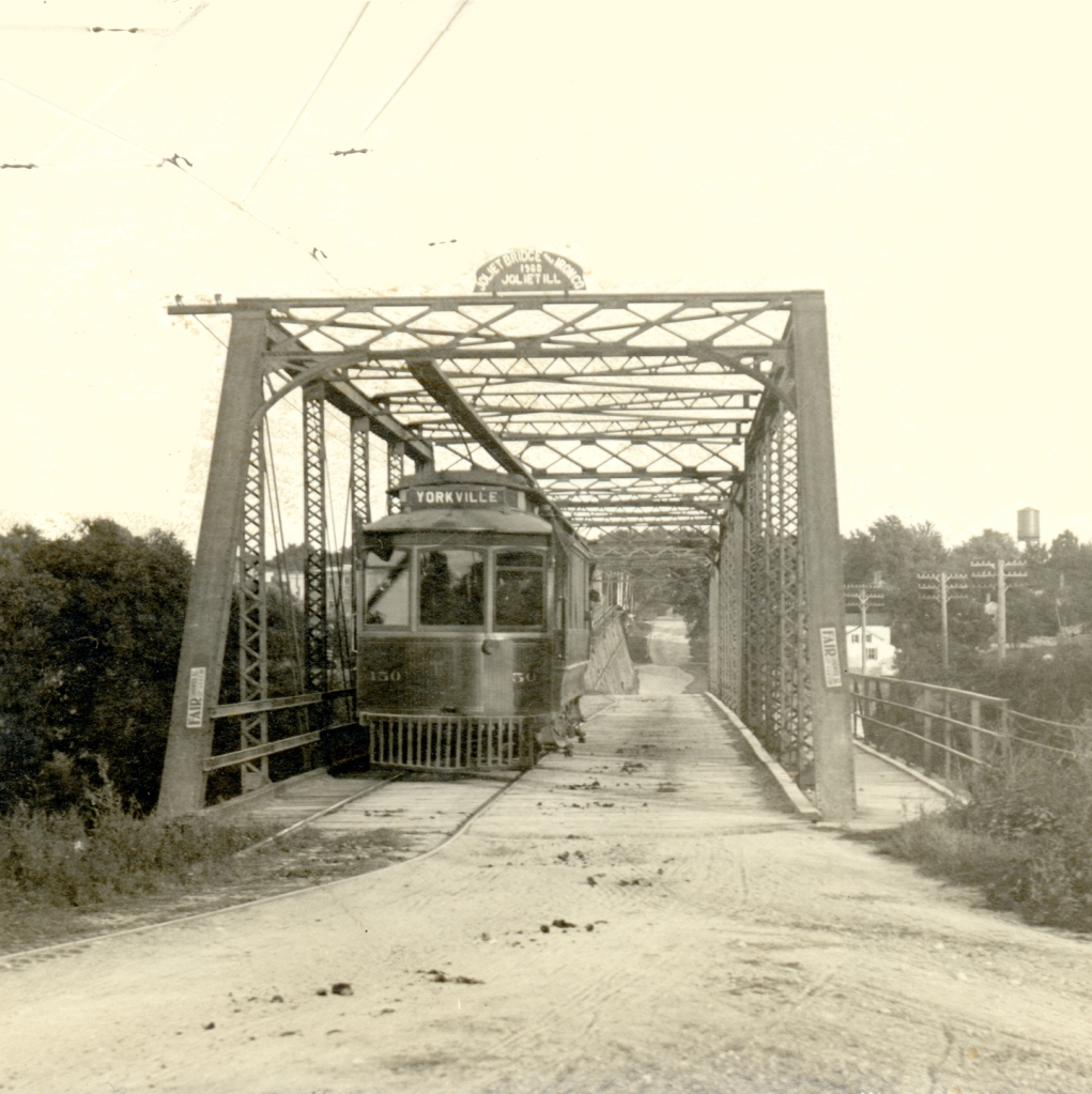
The box truss iron bridge built with trolley company assistance in 1900 to carry interurban cars across the Fox River at Oswego. It replaced the first iron bridge at Oswego built in 1867, and was itself replaced in 1937 to carry increasing motor traffic across the river. (Photo by Dwight Young in the collections of the Little White School Museum)
Among the issues that had to be hammered out was who would pay for improvements the line required, such as either strengthening or rebuilding the Oswego Bridge to carry the heavy trolley cars across the river. In addition, the company pledged “that in every way possible the company would guard against frightening horses” or otherwise interfering with traffic on the roads alongside and on which the trolleys would run. In the end, the trolley company agreed to pay $3,500 towards the cost of a new, stronger box truss iron bridge to replace the existing 1867 tied arch structure at Oswego. The other issues were ironed out as well, including how the trolley line would get across the Chicago, Burlington & Quincy’s Fox River Branch rail line in Oswego.
Interurban trolley car (center of the photo) approaches the west end of the Oswego Bridge about 1903 enroute from Aurora to Yorkville. The tracks crossed the Fox River on the Oswego bridge and then turned south along Main Street.
Residents of the towns the trolley would serve were, in general, enthusiastic about the new, all-weather transportation option. As Kendall County Record Publisher John R. Marshall noted in a Dec. 13, 1899 commentary: “With only four reliable trains a day, it was hard for one to come here and be so late getting into Chicago as is necessary with the regular passenger train. With the electric accommodations, one can go to Aurora and take an early morning train to Chicago.”
After crossing the Oswego Bridge, the interurban line climbed the Washington Street hill and crossed the CB&Q Railroad tracks on a 300-foot timber trestle. (Little White School Museum collection)
Construction began in the spring of 1900 and by June 27, the tracks were completed from Aurora to the west end of the Oswego Bridge.
“Operation of the electric road from the bridge will be commenced this Tuesday afternoon by a free ride of the town and village officials to Aurora and back,” the Record’s Oswego correspondent wrote in that week’s paper. “Yorkville will have to wait about three months longer before enjoying such privilege.”
This 1903 map shows the interurban route through Oswego. Look closely in the lower left at the siding at the Oswego Cemetery. Special funeral cars that carried mourners to this cemetery and farther south, to the Cowdrey Cemetery used this siding and the one at Cowdrey for funerals. (Little White School Museum collection)
Regular service began in early July from Aurora to the terminus at Oswego, and use proved enthusiastic—and frequent. As Marshall wrote on Aug. 1: “That the Aurora and Yorkville electric road will be a great convenience and daily comfort is shown by the way it is used now between Oswego and Aurora. Every day parties drive up from about here [Yorkville] to Oswego and take the car there for Aurora, saving 12 miles’ [round trip] drive.”
Work continued feverishly the rest of the summer and into the fall of 1900 on Oswego Township’s new Oswego Bridge. Construction was also ongoing on an impressive 300-foot trestle at the east end of the bridge designed to carry the electric line up Washington Street over the CB&Q tracks to the Main Street intersection.
By late December, the new bridge and trestle, along with the tracks into Yorkville were finished and regular trolley service had begun, linking downtown Aurora through Montgomery and Oswego with downtown Yorkville. The first car arrived at the Kendall County seat at 10:45 a.m. Saturday, Dec. 22, 1900.
“There were two cars down—one with the Aurora guests, the other empty to return with a number of the distinguished populace of Kendall’s capital,” the Record reported on Dec. 26. Welcoming the new arrivals was Record publisher Marshall, who had also welcomed the first railroad train on the Fox River Branch into Yorkville 30 years before.
At Washington and Main streets, the trolley line turned south to follow Main out of town. This was also the village’s trolley stop, with a waiting room in the building at right just behind the fire hydrant. Note the stack of wooden bread crates. Fresh bread from Aurora bakeries was delivered early every morning. The Little White School Museum has two in its collection, including on on exhibit that was repurposed as the village’s ballot box. (Little White School Museum collection)
The interurban, providing hourly round trip service from Yorkville to Aurora from 7 a.m. until 11 p.m. at affordable rates, was part of a vast interurban network that, it was said, allowed passengers to travel via trolley from the Mississippi River, with transfers, all the way to New York City.
Note the two passengers who’ve just stepped off the interurban, likely after a shopping trip to downtown Aurora. (Little White School Museum collection)
In an era of terrible roads, the interurban was a godsend, carrying passengers and perishable freight, including farmers’ milk, to and from Aurora. Everything from fresh bakery bread to college and high school students to office workers to shoppers rode the trolley to and from Aurora daily. For instance, war hero, musician, and star athlete Slade Cutter rode the interurban to Aurora to attend East High School. The line ran right past the family farmhouse (which still stands at the corner of Ill. Route 17 and Orchard Road) during a time Oswego High School only offered a two-year program.
Motor vehicles shared in-town streets with the interurban lines, making driving on them often an adventure. Here, an auto rattles south on still unpaved Main Street about 1910 in Oswego while sharing the road with the trolley tracks. (Little White School Museum collection)
But a little more than a decade after the line opened, it and others throughout the nation were under financial assault from the burgeoning number of automobiles and trucks—and government support for them.
It wasn’t so much the improved vehicles that doomed the trolleys, but the rapidly improving roads they traveled on—and their funding. From the time Illinois was settled until 1913, road maintenance was the responsibility of township property owners. Each voter—meaning men during that era—was required to work on road maintenance or to pay money in lieu of work. But with the advent of affordable, dependable motor cars and trucks, the old system was proving unequal to the task of road maintenance and construction. So in 1913, the Illinois General Assembly passed the Tice Act, removing the work requirement and replacing it with a property tax levy to fund road construction and maintenance.
An interurban car at the terminal in downtown Yorkville. It’s been turned around on the trolley line’s wye track and is ready to head back north through Oswego and Montgomery to Aurora. Note the advertisement for the Kendall County Fair. (Little White School Museum collection)
At the same time, the public was also insisting on more and better roads, and in what proved a momentous policy decision, U.S. politicians decided that tax dollars should only fund construction and maintenance of roads and not the rails used by railroads and trolley companies. Although few realized it at the time, the policy meant the substantial government subsidy favoring road transport would gradually result in curtailing all of the nation’s rail systems.
Interurban trolley ticket for a passenger fare from Aurora to Oswego from 1918. Note the “War Tax” schedule in the upper left. The tax was levied by the Federal government to help pay for World War I. (Little White School Museum collection)
And with that profound change in motion, in 1918, in spite of the nation’s involvement in World War I, Illinois voters approved a $60 million bond issue to build a system of all-weather paved roads to connect with every county in the state, the bonded indebtedness to be paid through gasoline taxes. The measure passed overwhelmingly. Here in Kendall County, the vote was 1,532-90.
A new iron bridge crossed the Fox at Oswego in 1900 to carry interurban trolley cars across the river, along with regular road traffic. Above, a trolley car is captured on its way from Yorkville to Aurora. (Little White School Museum collections)
The interurbans were simply unable to compete with the combination of increasingly inexpensive, efficient, and dependable motor vehicles and publicly financed roads. Starting in the 1920s, one by one, the interurban lines closed down, went bankrupt, or both.
On Aug. 6, 1924, the Record reported that “Through an order from the Illinois Commerce Commission, the interurban line from the [Fox River] park south of Montgomery to Yorkville will be discontinued.” In the event, the line carried on until Feb. 1, 1925, finally succumbing to the advance of transportation technology and the national consensus to subsidize roads but not rails.
Today, there are scant reminders of the trolley era, but look closely between the road and the railroad tracks the next time you drive Van Emmon Road into Yorkville—especially this time of year with trees and shrubs leafless—and you will see some of the last evidence of the old trolley line that was once such an important part of the area’s transportation system.
For more than a century, the iconic Schickler Block at the northwest corner of Washington and Main streets in Oswego’s downtown has been attracting a wide range of businesses and their customers.
The block of three brick storefronts was built in 1899 by Oswego saloonkeeper and businessman John Schickler in the popular Eastlake architectural style. The block complemented the two-storefront Knapp Building to its immediate north, which, in turn, was adjoined by the Oswego Saloon building.
The southwest corner of Main at Washington Street as drawn in 1885 by the Sanborn Fire Insurance Company. (Library of Congress collection)
John Schickler was born about 1870—sources vary—here in Illinois, the son of Bavarian immigrants Peter and Louise (Weber) Schiekler.
Peter Schiekler (under the Americanization of his name, Schickler) was naturalized in Aurora on Nov. 1, 1876. In the 1880 U.S. Census he was listed as a cigar maker. By 1910, he owned his own cigar store in Aurora.
Son John grew up in Aurora, where he married Katherine Olinger on Nov. 24, 1892, at which time he was still spelling his last name as Schiekler, although, like his father, he apparently Americanized it soon after to Schickler.
Soon after they married, the couple moved to Oswego where John managed and eventually bought one of the village’s two saloons—and where they had two children, Clarence, born in 1893 and Ruth, born in 1897.
By 1899 Schickler had raised enough money to finance the purchase and demolition of the small wood frame meat market building at the northwest corner of Main and Washington streets.
The Schickler Block showcasing the ornate corner bay window with curved glass to each side of the central window. (Little White School Museum collection)
“John Schickler has bought the part of the old Chapman lot fronting Main street, including the best corner in town,” Kendall County Record Oswego correspondent Lorenzo Rank announced in November 1897. It was a good location for a new structure—Charles Knapp had built his two-storefront brick building just north of the new building site a year or two before, and the new Oswego Saloon shared its south wall with the Knapp building.
Arrangements took some time, but on March 22, 1899, Rank reported that: “John Schickler has commenced excavating for his 65 foot front brick building at the corner of Main and Washington.”
The new building’s brickwork was completed by the end of May with interior finishing work continuing through June and July. In early August, Oswego barber Frank Van Doozer became the new building’s first tenant. As Rank reported on Aug. 9: “Frank Van Doozer has moved his quarters and is now having the handsomest barber shop that ever was in Oswego. It occupies the center room of the new Schickler block, and is the first place opened in that building.”
The new Schickler Block as illustrated on the 1902 Sanborn Fire Insurance Company map of downtown Oswego. Pink denotes brick construction, yellow wood construction, and blue stone construction. (Library of Congress collection)
The building’s second tenant had to wait for the building’s final touches. On Sept. 6, 1899, Rank reported in the Record’s “Oswego” news column: “H.S. [Harry] Warner has moved his [grocery] store into the corner room of the new Schickler block and now has the toniest place of business ever had in town. There is an elevator to the basement and everything is arranged for the greatest convenience.” Warner had been in the Oswego grocery business since the previous year when he bought out his uncle, Andrew Gray.
So things were definitely looking up for Schickler’s commercial real estate venture, with two of the new building’s storefronts rented, and the hall above Van Doozer’s barber shop rented by the Oswego Camp 1401 of the Modern Woodmen of America. Only the north storefront remained vacant as the new year of 1900 dawned.
But then, on the evening of March 14, disaster struck. The Record reported the whole story from Oswego in their March 21 edition:
BRICK BLOCK BURNED
About nine Thursday evening when the Woodmen hall was well filled with people enjoying a home talent theatrical performance, the cry of fire was raised and when ascertained that it was in the next building there was a lively getting out, but no panic resulted.
The fire was in H.S. Warner’s store; the firemen responded promptly, energetically went to work, and at first it seemed that it might be extinguished, but very suddenly it flashed out and enveloped the whole inside of the store. That the Schickler block was doomed was then evident and the efforts were exerted towards confining it there, which too began to look doubtful, and Aurora was telephoned to for help, but before a start was made from there, they were notified that the fire was under control and no assistance needed.
The event has thrown a gloom over Oswego; the west side brick block, with plate glass front was its pride, and now the half of it consists in fire-gutted walls; its young merchant just fairly started in life now broken up; but everybody is full of praise for the boys of the fire company; it is believed they done all that was possible.
The loss of Schickler on the building is put from $6,000 to $6,500, insurance $400; that of Warner, stock of goods, $3,500, insurance $2,000—he saved nothing but his ledger at great risk. W.P. Wormley saved his two barber chairs and razors; the other furniture worth $50 was lost.
The Knapp block, across a narrow alley, had its side windows burned out; the occupants, Croushorn, furniture store, and Malcom, meat market—removed their goods.
The Woodmen, because of their show, were all present, and in removing their effects from their hall, Ed Smith, Lew Inman, and John Russell had a thrilling experience; they with others were on taking the piano out, being on the forward end and therefore walking backwards and just as they had entered the stairway the firemen rushed in from below with their hose with full pressure stream on, which struck the upper or hind carriers in the face and naturally made them let go of the hold, causing the piano with the three men in front of it to be thrown down stairs in a heap, but no one was hurt nor was the piano much damaged.
The north room of the burned building was vacant, and the upper story was being converted into dwelling apartments—making a hotel of it was talked of—Harley Richards was doing the wood-work and had his tool chest there, which was burned; loss at least $40.
The wind was from the west, which made it quite hot on the east side of the street, and some of the glass in the store windows was cracked by the heat; the Edwards store and the Figge barber shop suffered most.
The men to whom the water works are due are now topmost in esteem. It is said that Mr. Schickler will rebuild the block at once.”
As a side note, the comment about the water works above refers to the controversy that arose in the late 1890s when the village board decided to build a water tower and a system of water mains throughout much of the village. Some Oswego residents opposed the expenditure, but a few major fires, like the one in the Schickler Block and the July 1895 destruction of Wayne’s grain elevator, soon changed minds. Although the water system was in operation, the fire hose and hose cart Oswego had ordered for the village’s first fire brigade had yet to arrive. So Aurora was telephoned, and fire hose was rushed south to fight the fire. While the elevator was a total loss, the water system kept surrounding buildings from going up in flames with the elevator.
But back to the disaster at hand. As it turned out, the loss seems to have proved too much for Warner, and he never restarted his grocery business. Instead, he apparently used his insurance money to buy one of the storefronts in the Knapp Building. That opened up the best location in Oswego—at least according to Lorenzo Rank—for John Schickler to open his own saloon in his building’s southernmost storefront.
Work on repairing the Schickler block began in April with Harry Richards’ gang doing the carpentry and Aurora mason Chris Armbruster of Aurora handling the masonry work. On May 9 Rank reported from Oswego that: “The rebuilding of the Schickler block has progressed very rapidly. It is being made much more imposing than it was formerly; the corner bay window is ahead of anything that Oswego has had yet.” And later that month, the village extended a municipal water main to the building.
Then on June 27, Rank reported: “The Schickler saloon has been transferred to the new building on the corner, and will be the most complete establishment of the kind in these parts. The population of Oswego is perhaps near to 800, and so it is doubtful whether any place in the state of as many thousands of inhabitants can show anything better in the shape of saloons,” and adding on Sept. 5: “The John Schickler family moved into the new and elegant quarters above the saloon. And by the way, one of the bent glass lights of the bay window dropped out and down on the sidewalk Saturday.”
Crossing Washington Street sometime around 1905 wasn’t nearly as complicated–or dangerous–as it is today. The Oswego Banking Company occupied the south storefront of the Shickler Block from 1904 until 1912. Note the end of the tre(Little White School Museum collection)
In November 1903, it was announced that Oswego was finally getting another bank. It previously had a bank a decade earlier, a private one that Levi Hall operated out of his drug store. Hall’s bank went bankrupt in the Panic (Depression) of 1893.
As reported in the Record:
BANK FOR OSWEGO
Mr. Earl and Byron Joy of Plano
Interested–Will Start as Private
Bank, Hoping to Grow.
After years without a bank, Oswego is about to have another banking institution and a place at home to do the local business. The bulk of the business is now done with Aurora banks and the convenience and apparent safety of these houses has drawn the patronage of Oswego people to such an extent that it will doubtless be difficult to get it back to the Kendall county town.
“A Record reporter was in Oswego and tried to find someone who was on the inside of affairs and intimately acquainted with the proceedings but it was almost impossible to discover anyone who could say that he knew exactly what was going to be done. An interview with several business men disclosed the following facts, which seems to be the gist of the public sentiment in our neighboring town:
“The bank is to be financed by F.H. Earl and Byron Jay of Plano with two young men from Michigan interested. The bank will be started as a kind of “feeler” and if it promises to pay out, a stock company composed of local farmers and business men will be organized and a State bank inaugurated. There is no local capital interested in the undertaking whatever, and it is the general impression that it will be rather up-hill business owing to the previous experience in Kendall county with private banks.
The new institution will be situated in the Schickler block, where a room 15×20 feet has been partitioned off and the fixtures will be placed in a few days. The walls have been made sound proof, an 8-ton safe will be used instead of a vault, and the promoters expect to commence business on the first of December.
“The building has been leased by Mr. Schickler for two years with the privilege of five years, so it looks like business.”
The next week, the bank’s organizers issued some corrections to the previous week’s bank story: “F.H. Earl of Plano informs The Record that there was an error in the write-up of the new Oswego bank to be established. It is Mr. D.M. Jay and not Byron Jay who is to be interested in the firm. Our reporter was told that it was Mr. Byron Jay, hence the error. Mr. Earl further says that Mr. E.W. Bowman of the Bowman bank, Kalamazoo, Michigan, is to be interested in this new bank, and that Mr. Phelps will have charge of the same.”
The bank proved a success. Schickler apparently ran his saloon in the middle storefront, while the south storefront housed the bank and the one on the north end was a barber shop.
King Flipper cigars were briefly made in the basement of the Schickler Block in 1905. Note the “Oswego, Illinois” printed on the box liner in the lower right above. (Little White School Museum collection)
In 1905, a new business joined the others. As the Record reported from Oswego on Aug. 30: “New industries have spring up and are springing up here. Charles Reiger is making cement blocks. The Schickler cigar factory is now in operation. A rug factory is promised and also a tannery and dye works.” It was probably not coincidental that Schickler’s father was a cigar maker who owned his own cigar store in Aurora.
From that time on, numerous businesses came and went in the building, although the north end barber shop held on for many years.
Oswego State Bank, Main and Washington, after its move from the Schickler Block. Photo taken about 1913 by Dwight Young. (Little White School Museum collection)
In January 1905, Oliver Burkhart took over management of the Oswego Banking Company and by 1911 the Burkharts owned the company. That year, the Burkharts decided to build a new multi-storefront building at the southwest corner of Main and Washington streets to house their bank, as well as the Burkhart & Shoger auto dealership, the village telephone exchange, and the Oswego Post Office. The new Burkhart Block was finished in 1912 and the bank moved there at once.
Schickler sold his saloon business to Jacob Frey in August 1912, where it occupied the corner storefront. Schickler retained ownership of the block of storefronts as his business became more and more centered around real estate.
In 1914, foreshadowing what was to come on the national level, Kendall County voters approved a referendum making it illegal to sell alcohol, and that eliminated the saloon business in Oswego, including Frey’s saloon in the Schickler Block of brick storefronts. In December of that year, the Record reported that: “John Schickler is remodeling his store preparing it for a grocery and meat store. He intends making a cut rate house, meeting the demands and prices of the people.”
Charles Schultz is leaning against the door of his grocery store on the east side of Main Street in this photo taken about 1909. He’d move across the street in 1916. (Little White School Museum collection)
Schickler operated his grocery business for a couple years and then in the Dec. 29, 1915 Record it was reported that: “J. P. Schickler has sold the building he has been occupying to Messrs. Charles and Richard Schultz, who will move their present [grocery] business to that location, occupying the living rooms above the store building. The J.P. Schickler family will move to the Todd house.”
Charles “Charlie” Schultz had been in the Oswego grocery business for several years, occupying a storefront on the east side of Main Street in the old Union Block. The move to the Schickler Block put him on arguably the busiest, most visible corner in downtown Oswego. Not only was road traffic heavy past the corner, but the interurban trolley cars stopped on Main Street diagonally across the intersection from the Schickler Block.
Charles and Richard Schultz proudly stand outside their new store in the Schickler Block in 1916. (Little White School Museum collection)
As the Record reported on Jan. 5, 1916: “The company of Schultz Bros. recently purchased the John Schickler block and is now moving grocery and meat departments to that location. The barber shop will be transformed into a hardware store extending to the rear of the building. Mr. Charles Schultz will move into the rooms vacated by Andrew Swanson. An unusually attractive corner is being made by the company and one of the most metropolitan stores in the county.”
With Schultz brothers occupying the two north storefronts, Oswego barber Gus Voss moved into the north storefront. Charles Schultz occupied the apartment above the south storefront—the grocery store—with its ornate bay window, while brother Richard moved into the storefront above the hardware department in the center storefront.
The elegant apartment over the Schultz grocery store where Mr. and Mrs. Charles Schultz lived. The photo was probably taken in the early 1920s. Note the Victrola and the grand piano. (Little White School Museum collection)
The next year, however, Richard and family left the partnership. He first worked as a traveling sales man for the Heinz Pickle Company and then the National Oil Company. He and his wife left Oswego in 1918 to move to Michigan City, Indiana to be nearer his company.
Owning the company and the Schickler Block on his own now, Charles Schultz continued to grow his business and to innovate. In 1922, he added a refrigeration-freezer plant to his store basement where Schickler’s cigar factory had been, renting space to village residents. And in 1923, he began delivering groceries in a brand new REO Speedwagon truck. He was also an innovator at home, buying one of the new ornate console radios in 1922.
Schultz briefly accepted a new partner, Robert Peterson, in 1923, but the partnership didn’t last long before Schultz was back to sole ownership.
Charles Schultz (left) and Carl Bohn show off their new Birdseye freezer about 1940 in their Shickler Block grocery store. (Little White School Museum collection)
About that time, Schultz hired young Carl Bohn to work in his store, introducing young Bohn to his lifetime career.
Schultz continued to innovate to keep his business solvent as the Great Depression began in 1929, while also staying involved in local Oswego politics and civic life—he was a Shriner, a member of the Oswego Village Board, and served as president of the school board. In 1931, he mounted a large electric clock in his grocery store window to draw window-shoppers. And he was a sponsor of amateur variety shows held on Main Street in front of his store every Saturday night, starting in 1937.
Frozen food proving more than a passing fad, Schultz had a Birdseye freezer installed in 1940. As the admiring Kendall County Record reported on April 10 of that year: “If you want to see something good to eat, just step into the Schultz grocery store and ask to see the frozen foods he has on display.”
Bohn’s grocery store in a photo taken about 1937, a year after Bohn bought the store from Charles Schultz. (Little White School Museum collection)
By the spring of 1946, Schultz was ready to retire after decades in the Oswego grocery business. And who better to take over ownership of his business than long-time employee Carl Bohn? As the Record reported on April 3 of that year: “Carl Bohn and his brother-in-law, Marion Bangs, have purchased the Charles Schultz grocery business, and took possession April 1. Mr. Bohn has been employed in the store for 25 years. Mr. Bangs, formerly a farmer in Iowa, and his wife will move to Oswego when they can find a home. He is a pleasant fellow and will be a welcome addition to the businessmen of Oswego. The same line of good groceries, meat and frozen foods will be carried by the new firm. Mr. Schultz, who is retiring until he has had a good vacation, has been in the grocery business for 51 years, clerking when only a schoolboy and having his own business for 35 years.”
Carl Bohn opened his new supermarket, 60 Main Street, in April 1954 on the east side of Main Street between Washington and Jackson. Bohn’s, then operated by his son, Kenneth, closed in 1981, and the store was remodeled into a professional office building. (Little White School Museum collection)
Bohn instituted several business upgrades including introducing grocery carts so customers could serve themselves. By the early 1950s, however, it was clear if he was to remain competitive, he was going to have to move to larger quarters. So he purchased the old National Hotel lot at 60 Main Street and built a new brick grocery store that he opened in 1954.
According to the April 8, 1954 Oswego Ledger: “The new Bohn’s Grocery Store holds its grand opening this week with special entertainment and special sales. The store, located in Main Street, is of cement block construction with a brick front. Has a big well-planned interior with the latest and most modern fixtures. Among the many opening features will be the violin playing of Jim McGlue all day Friday, the organ music of Lorane Peshia Wednesday and Thursday evenings, and the arrival of Little Oscar and his Wienermobile on Saturday afternoon.”
In 1954, Little Oscar visited Oswego to help inaugurate Carl Bohn’s new store. In 1958, Little Oscar came back (above) to help the community celebrate its 124th anniversary. (Little White School Museum collection)
As it turned out that was about the time the Oswego Post Office was suffering from a space crunch of its own. So when the south storefront in the Schickler Block became available, the post office moved from its Main Street Burkhart Block storefront to the Schickler Block.
As Ford Lippold explained in the March 24, 1955 Ledger: “Postmaster G.C. Bartholomew states that the post office fixtures will be moved to the new building on the northwest corner of Main and Washington Sts. (formerly occupied by Bohn’s Supermart) this weekend. Operations in the new plant will begin Monday morning. Postmaster Bartholomew requests that all who possibly can pick up their mail Saturday afternoon and evening so that moving will be facilitated. The new quarters, about a third larger in size than the present building, will be equipped to offer post office patrons handier and more efficient service.”
Oswego’s post office moved from South Main Street to the Schickler Block in 1958. It would stay there until the ‘new’ post office was built at Madison and Jackson streets in 1969. Homer Durand took this photo before Art Mayer replaced the Oswego Cleaners with Art’s Barber Shop. (Little White School Museum collection.
Also during the 1950s a number of businesses opened in the two northern storefronts, including the Bonnie Rose Bakery and, in 1958, Art’s Barber Shop, which occupied the north storefront. Art Mayer, a U.S. Navy veteran of World War II, had married a local girl, Ina Mae Borneman and began working in the old Voss barber shop on South Main Street, then owned by Roy Roalson. By 1958, Mayer was ready to split off and open his own shop, which he operated until his retirement, after which his son, Jim, took over until he, too, retired.
The Schickler Block as it looked in 2011 shortly after a major decorating facelift, which unfortunately didn’t include restoring the ornate corner bay window. The storefront at right still houses a barber shop. (Little White School Museum collection)
The post office occupied the south storefront until March 1969, when it moved to its current location at Madison and Jackson streets.
Since then the Schickler Block has been fully occupied by many different retail and service businesses. And it remains a vital part of Oswego’s historic downtown business district, as Lorenzo Rank put it in 1897, “the best corner in the village.”
Look at the buildings in Oswego’s small downtown business district, and they look so solid you get the impression they’ve always been there. Which, of course, they haven’t—everything was new at one time or another, even those familiar downtown storefronts.
Throughout the years, I’ve done quite a bit of research on individual aspects of Oswego. I’ve decided to get as much of it as possible down and available online to anyone interested. Because as we all know—or should know—the stuff you post online is forever.
The Knapp Building (left) and the Oswego Saloon building were sporting their new white brick storefronts in 1958 when Oswego Photographer Homer Durand took this photo. (Little White School Museum collection)
I previously sketched the histories of the landmark Union Block and Rank Building on the east side of Main Street. This week, I figured I’d mosey across the street and look at the histories of the Oswego Saloon and adjoining Knapp Building. Today, the Knapp Building houses the Masonic Hall and the Oswego Family Restaurant, while the old Oswego Saloon is the location of the Happenstance Goods antique store.
“Oswego Saloon?” I imagine you’re wondering. And yes, a major downtown building originated as a saloon. And not just any saloon, either, but arguably the most elegant watering hole in town.
Saloons in the late 1800s were important to municipalities throughout northern Illinois because they generated license revenue. This was the era before municipalities were allowed to levy real estate or sales taxes. The only municipal revenue sources were fines for violating village ordinances generated by local justices of the peace—and the aforementioned saloon licenses, plus billiard table licenses.
The Oswego Saloon location as depicted on the 1885 Sanborn Fire Insurance Company map of downtown Oswego. The yellow color denotes wooden frame buildings, while blue represents stone construction. (Library of Congress collection)
In fact, the revenue from Oswego’s saloons—there were at least two, often three in town—financed the village’s first municipal water system, including the elevated tank and water mains, along with the equipment for its first fire brigade and the first system of concrete sidewalks.
That municipal revenue was one reason prohibition of alcohol was such a hard sell. Saloon licenses were set at $1,000 per year in the late 1890s, which amounts to about $34,000 in 2024 currency, before being lowered to $750 in the late 1890s after some of those improvements had been paid off.
And please note, today’s Oswego Inn at Main and Jackson, formerly Johnson’s Tavern, did not exist until the first third of the 20th Century after Prohibition ended.
This image of the west side of Main Street looking north from Washington Street is reminiscent of photos of western cow towns. It was probably taken sometime in the 1870s when the building that would be replaced by the Oswego Saloon was a grocery store. (Little White School Museum collection)
Oswego’s 19th Century saloons were all located on the west side of Main Street between Washington and Jackson, in a stretch of frame and limestone storefronts that resembled, more than anything else, one of the cow towns out west of the Mississippi. By the 1890s, those buildings were showing their age, and both in-town and out-of-town business owners were thinking about replacing the old buildings with new, modern ones.
On Oct. 19, 1897, the Kendall County Record’s Oswego correspondent, Lorenzo Rank, reported: “The Schroeder saloon building is being demolished by Aurora parties to whom it belongs and a new one will be erected in the place of it.” The building fronted on Main Street and bordered the south side of the alley that ran east to west across Main Street between the Union Block and Rank’s Oswego Post Office on the east side of the street.
The new building was designed with elements of the old Italianate style, but it also included some more modern Eastlake design elements, creating an interesting transitional style all its own. It was the first major building project downtown since the Star Roller Skating Rink had been completed across the street from the new saloon back in 1885. The frame rink building was situated on the lot north of Rank’s Oswego Post Office building on the site of the old National Hotel that burned with everything else on that side of Main Street in February 1867.
The 1898 Sanborn map of downtown Oswego shows the new brick Oswego Saloon building—the pink color denotes it was of brick construction. (Library of Congress collection)
On Nov. 3, Rank reported construction on the new saloon was moving forward at a brisk pace. “The new brick building, which is to be built of the most modern style of architecture and finish, will be the pride of the town,” he wrote. “We folks who have been in the habit of saying that ‘saloons are no good’ will have to dry up. The building is about ready for the roof.”
Not everyone in town was impressed with the new saloon—or any saloons for that matter. In February as the building was nearing completion, Margaret Phillips Young, president of the Oswego unit of the Women’s Christian Temperance Union, caustically complimented the people of Oswego, noting that, among other things, they maintained four churches for salvation, and three saloons for damnation.
As completed, the building featured the modern saloon on the first floor and an apartment above.
On March 23, Rank noted the building’s interior decoration was nearly completed, and—although himself a teetotaler—was so overawed at the saloon’s beauty he was almost unable to express himself: “J.A. Schmidt and Ira Ackley have been doing the decorating of the new saloon building, all of which is most magnificent. Every room is of different color and pattern. The wine room—well, gorgeous or splendid—fail to express the sight of it,” he wrote.
The saloon opened for business in May 1898. In his May 4 “Oswego” column in the Record, Rank wrote: “Michels and Conway Sample Rooms was artistically painted on the large plate-glass of the new saloon Monday, which had opened for business in the morning.”
Since that opening, the building has been the site of numerous businesses through the years, including the All-American Male men’s wear store. Currently, as noted above, it’s the site of the Happenstance Goods antique store.
Charles Knapp’s new two-storefront building under construction on Main Street in 1898. (Little White School Museum collection)
While the Oswego Saloon’s construction was underway, Oswego businessman and property investor Charles Knapp was busy planning an even larger building on the two lots adjoining the saloon site to the south.
On Oct. 20, 1897, Rank reported in his “Oswego” news column that: “The fall weather thus far has been most opportune for building purposes. It is said that if it could be depended upon for a month longer, two more or rather a double brick building for stores below and hotel above would be constructed adjoining the one now on building, and thus making a solid brick block of 66 feet frontage. It will be accomplished early in the spring if not sooner. Charles Knapp will have it done having secured the Troll premises for the enterprise.”
The 1885 Sanborn map shows the site of Charles Knapp’s proposed brick two-storefront commercial building. (Library of Congress collection)
The new building would also be built in the same fashionable Eastlake style as Knapp’s home on Adams Street.
George Troll was a long-time saloon owner in downtown Oswego who was doing business in one of the frame buildings where Knapp planned to build his new two-storefront building. Knapp himself was the owner of the meat market in the other adjoining building slated for demolition and replacement with a new brick building.
Wollenweber & Knapp’s stockyards, and the stretch of railroad track where their livestock loading chute was located, north of Jackson Street and across the tracks from the Oswego Depot, from the 1898 Sanborn Map of Oswego. (Library of Congress collection)
Knapp was a German immigrant who had been engaged in the livestock and related meat market business in Oswego for more than two decades. Mostly he worked in partnership with Henry Wollenweber. The partnership of Wollenweber & Knapp owned acreage north of Washington Street between Adams Street and the Fox River where they grazed cattle, and also maintained the Oswego Stockyards between North Adams at the railroad tracks north of Jackson Street. They also owned a slaughterhouse north of Waubonsie Creek. They annually shipped thousands of head of cattle and hogs to market that had been driven into town by farmers in the surrounding countryside. During 1880, for instance, the firm shipped 108 railcar loads of hogs and cattle from Oswego.
Oswego livestock dealer and businessman Charles Knapp built this Eastlake style home at the corner of Adams and Jackson streets in 1889. (Little White School Museum collection)
Knapp also built a home in the Eastlake style adjacent to his grazing land at the northwest corner of Jackson and Adams streets. The home stood until it was demolished in recent years to make room for a new apartment block.
On June 22, 1898, Rank reported from Oswego that: “The Knapp buildings are nearly completed and now receiving the finishing touches. The metallic ceiling of the hall and rooms connected with it are made dazzling by paint.”
After the building’s completion, George Croushorn moved his furniture business into the south storefront. Croushorn was also the village’s undertaker. Knapp owned the meat market in the north storefront, although it was managed by a number of butchers through the years. James Malcolm eventually bought the meat market from Knapp and ran it for many years.
The Knapp (left) and Oswego Saloon buildings still sported their original cast iron street level storefronts when this photo was taken about 1944. They would be modernized in 1958 with smaller street level windows. (Little White School Museum collection)
The Knapp and Saloon buildings housed a number of businesses through the years. The saloon was put out of business when Prohibition, first local and then nationwide, came in, while the Knapp Building housed various businesses until it was purchased by Oswego Masonic Lodge 303, AF&AM in 1924. Since then, the north storefront has housed a number of restaurants—currently the popular Oswego Family Restaurant is doing a lively breakfast and lunch business there—while the Masons use the upstairs of the building as their meeting rooms and the downstairs north storefront as a hall where hundreds of public events have taken place through the years.
Today—some 126 years after their construction—the two buildings, although their storefronts have been modified and “updated” through the years (unfortunately losing their distinctive cast iron fronts in 1958), still stand as viable and familiar landmarks in Oswego’s historic downtown Main Street business district.
Even before Oswego became an official village, the area along what is today the east side of Main Street between Washington and Jackson streets was the center of growing mercantile activity.
Oswego, situated at the southernmost lobe of The Big Woods that extended north to Batavia and east to Naperville was described as a town of “30 or 40 wood buildings” by U.S. Government surveyors in 1838. (U.S. Township Survey Plats, Illinois State Museum)
The timeline on Oswego’s earliest years is not entirely clear—the 1830s was a time of explosive growth in Oswego and the rest of Kendall County—but it seems Levi Arnold had already established his store in the middle of that block by the time he and Lewis B. Judson laid out the original village’s grid of streets and alleys in 1835. When the village was granted its post office in January 1837, Arnold became Oswego’s first postmaster with the post office located in his store.
The east side of Main drew a variety of retail businesses in the ground floor storefronts with offices and residences located above. In 1842, Samuel and Thomas Hopkins built the stately Greek Revival-style National Hotel across the alley on the north half of the block where Arnold’s store was located. When county voters agreed to move the county seat to Oswego from Yorkville in 1846, the first terms of the circuit court were held in the hotel until a new courthouse would be completed. The block’s stores and offices benefited from the business drawn by the county seat and it also continued to draw trade from a wide hinterland surrounding Oswego.
This poor quality photograph, probably taken about 1864, is the earliest image we have of the east side of Main between Washington and Jackson Street. It clearly shows the majestic National Hotel, along with the wood frame commercial buildings that made up the heart of downtown Oswego before the devastating fire of Feb. 9, 1867. (Little White School Museum collection)
On the eve of the Civil War, county voters decided that locating the county seat in its far northeast corner had been a mistake. In the days of travel by horsedrawn vehicles and on horseback, a more central location made sense. And in 1859, voters agreed to move the county seat back to centrally-located Yorkville. But when the Civil War broke out in 1861, construction on a new Yorkville courthouse were slowed. Not until June of 1864 was the new courthouse finished and the county records finally moved to their new—and permanent—home.
The loss of business due to the county seat’s move was an economic shock. And as if that wasn’t bad enough, in the late hours of February 9, 1867, an overheated stovepipe caused a devastating fire that destroyed everything on the east side of Main from Washington north to Jackson Street, with the exception of the National Hotel’s two limestone horse barns.
The Kendall County Record carried an detailed account of the disaster:
DESTRUCTIVE FIRE IN OSWEGO!
It is not often we are called upon to record the fact of an extensive conflagration in our county, but now have that duty to perform and no doubt the people of Kendall will feel grieved at the great loss, which has befallen one of their villages.
On Saturday night last, Feb. 9th, at 10.30 p.m., fire was discovered in Hawley’s grocery store, in Oswego, on the south side of Main Street. When the door of the store was first broken open, the smoke and heat in the room was so dense that it was impossible to enter and discover the cause of the fire. The supposed cause was that a very hot fire had been kept in the stove all day, the pipe if which ran very close to the wooden ceiling, and on leaving the store, the stove had been filled tip full with coal making the pipe so hot as to ignite the pine boards and thence fired the building.
This store was in the third building from the corner west.
The first building on the southern corner was occupied by a watch and clock repairer. Small one story house, loss about $900.
The next was Lockwood’s harness shop with Smith & Hawley’s law office upstairs; loss about $1,500.
The building that first took fire was owned by J.D. Kennedy, Esq., and valued at $1,000–no insurance. Hawley’s stock of groceries was not insured. Up stairs was occupied by W.L. Fowler, justice of the peace.
The next building was occupied as a meat market by Young and Snook, and upstairs by Mrs. Gates, a widow lady. She lost all her furniture and clothing and narrowly escaped suffocation in the smoke. She made her escape in her night dress. Her loss is indeed a heavy one. The building was owned by Mr. L.B. [Lewis Brinsmaid] Judson and worth about $600; not insured.
Mr. M.S. Richard’s hardware store and tin shop was in the next building. Stock and tools nearly all lost. He owned the building, which was insured for $600, and $400 insurance on the stock. Mr. R’s loss is serious, as he was doing a large business and a store of that kind is indispensable in a village.
The next building was owned by L.N. [Levi Newton] Hall, the druggist, and was occupied by himself and Mr. F. [Frederick] Sierp, a boot dealer below, and up stairs was Odd Fellows Hall. The building was insured in the Aurora Company for $1,000. Mr. Sierp was insured for $600 on his stock, but it will not begin to cover the loss, as he is thrown out of a flourishing business.
The Odd Fellows saved their regalia and the most of their furniture. Mr. Hall, the druggist, had his stock insured for $1,500 in the Peoria Company. He estimates his loss at $1,500 above insurance. A great deal of his stock was taken out of the store, but from its nature (so many glass jars) it was greatly damaged. He has now the store opposite, formerly unoccupied by M. Whitman, where he is fixing up for business again.
Mr. David Hall had about $500 worth of goods stored in this building, which were all lost. No insurances.
Next was the National Hotel, owned and managed by Moses F. Richards, Esq. The burning of this was a serious loss to Oswego, as a hotel is necessary, and this was a good one. The building was worth $2,000. The furniture was mostly saved. Building and contents insured in the Aurora Company for $3,500.
It was by great effort that the barns belonging to the hotel were saved. One had taken fire, but by hard work the fire was extinguished by the citizens–snow was the extinguisher used principally. Had these barns got into a blaze, the flames would have crossed the street and burned several dwellings. The dwellings on the north side of Main Street were in danger several times from the great heat created by the burning block.
The once busy street now presents a sorry sight. Ragged brick walls, charred and blackened ruins, battered stoves, cups, &c., are all that remain to mark the places where stood Oswego’s business block and Hotel.
This great accident is of course discouraging to the villagers at the present time, but they will take courage and place handsome substantial stores where the old and tried buildings stood.
From what we could learn of the parties burned out, the total loss is estimated at $12,000. Insured for $7,500–of which the Aurora Company has $6,500. But while estimating this loss it must be borne in mind that to replace new buildings of this capacity of those burned, will cost as much again.
The town[ship] and corporation records were also burned.
While the blaze was a serious economic blow, the community’s business leaders gathered and decided to rebuild as quickly as possible. Under the headline “To be Re-Built,” a short item in the May 2, 1867 Record reported: “The block of buildings that was burned down in Oswego last winter is to be replaced. The rubbish is being cleared away and soon phoenix-like, a new block will spring from the ashes. The new stores are to have brick fronts and stone side walls.”
As a nod both to the recent war to save the Union and the consortium the group of business owners formed to build the new block of stores, it was dubbed the Union Block and was designed in the then-popular Italianate architectural style. The buildings, which were to fill the lots between Washington Street north to the alley that divided the block in two, were to have brick storefronts with limestone side walls and substantial basements. The storefronts were to be embellished with decorative cast iron. Front store windows were limited in size only by the plate glass making technology of the day.
Later that year, Record Editor John R. Marshall decided to take day trip up to Oswego, reporting in the June 20 Record: “In Oswego today for the first time since the fire last February destroyed the main part of the town, I was surprised and pleased to see the improvements making. The large and substantial foundations of stone and brick now taking the place of the debris of the burnt district give promise that the enterprise of Oswego will be developed to such an extent that the trade of the rich country surrounding will be secured at home instead of seeking Aurora and other points. I do not see why Oswego cannot afford to supply the farmers with merchandise at as low rates as he can buy elsewhere. The promise of improvements now making is that Oswego intends to lead. Business is improving and all seem cheerful.”
The Union Block photographed about 1870 with the final touches of its decorative cornices completed and the storefronts all occupied with businesses. It would take a few years for the rest of the block north of the alley at the north end of the Union Block to become filled with buildings. (Little White School Museum collection)
By Nov. 7, the Record could report: “Oswego is alive and is doing the best she can. More has been done the last summer in building than has been done in the past ten years. Six fine brick and stone front buildings have been erected and are now nearly complete. The builders are Messrs. [Lewis B.] Judson, [James] Shepard, [John] Chapman, [Thomas] Greenfield, [Marcius J.] Richards, and [Levi N.] Hall. They will have the finest block in Kendall County.”
Merchants gradually moved into the new building as each of the storefronts was finished. On December 12, the Record reported: “We have at last a genuine Oswego advertisement and we earnestly request our readers in that vicinity to give the advertiser, Mr. L.N. Hall, a liberal patronage that his neighbors may see that it is good to advertise and do likewise. Mr. Hall has a splendid new store and is fitting it up at great expense; he’s an energetic young man and will fulfill his promises. Call and see him in the new block.”
This 1904 photo of the Funk & Schultz grocery store (Charles Schultz is standing in the doorway at right above) in the Union Block clearly shows the kind of decorative cast iron storefronts that once graced the block. They decorative fronts were gradually either completely removed or covered up to modernize the block’s storefronts. Sharp-eyed visitors, however, can still find some of the original cast iron elements in the block. (Little White School Museum collection)
The second floor halls over the main floor retail businesses were also slowly occupied. Hall’s drug store, located on the alley at the north end of the block of stores, reportedly the same spot Levi Arnold’s first store and post office in Oswego stood, welcomed one of the village’s most prominent fraternal organizations to the hall above the store. According to Record Correspondent Lorenzo Rank, reporting from Oswego in the Feb. 13, 1868 Record: “The Odd Fellows occupied their new hall over the drug store last Tuesday evening; they have as good a [club] room as can be found west of Chicago, all newly furnished.”
As 1868 wore on, businesses continued to move in and occupy storefronts in the new brick block. On May 7 the Record reported: “We would call the attention of our readers to the new advertisement of N. Goldsmith & Co., in another column. They have just opened a new clothing place in the new Union Block, Oswego.”
David M. Haight’s store at the northeast corner of Main and Washington streets in downtown Oswego. Haight went bankrupt due to the financial Panic of 1893 along with many other businesses include the village’s druggist and banker, Levi Hall. (Little White School Museum photo)
In the July 16 Record, Marshall decided to give Oswego another boost—while also probably hoping to gain a little more advertising from the village’s merchants: “Oswego has recently shown a commendable enterprise in erecting a fine large brick block. This block contains six large elegant stores. All of these but one are already in successful operation, their occupants are undoubtedly getting rich fast. As an evidence of what may be done we mention an instance. Mr. D. M. Haight came to Oswego in April and occupied one of the new stores. The first month he did a small trade. The second month his trade amounted to nearly $2,000. The third month, June, it was increased more than a thousand dollars. Mr. Haight is a gentleman and understands his business. He keeps a splendid assortment of goods and, is well repaid. One gentleman informed us that his trade, amounting to about $500 per year, formerly went to Aurora. Since the recent enterprise facilities have opened it has stopped there.”
David Haight opened his business in the corner storefront at Main and Washington, a location he would maintain until the financial Panic of 1893 drove both him and Levi Hall into bankruptcy.
The sturdy block of stores was not finally completed until June of 1870. On June 16, Rank wrote in his “Oswego” Record column that: “L.N. Hall and the Richards are finally putting a cornice on their store buildings. VanEvra is the architect.”
And with the addition of the decorative cornices to the Union Block, there it stood for several decades, with businesses coming and going, and uses varying for the halls located above the stores. During those decades, stores came and went, with technology causing some of the changes. Harness makers, for instance, gave way to the Klomhaus Chevrolet dealership.
Shuler’s Drug Store in Oswego as it looked to us in the early 1950s as the village’s squad of newspaper carriers prepare to head off on their afternoon delivery routes. Note the building’s decorative cornice is still intact. The stairway door to Shuler’s Toy Land up on the second floor is visible at right. (Little White School Museum photo)
In the 1950s, Alva Shuler, owner of Shuler’s Drug Store, located where Levi Hall opened his drug store nearly a century before, also opened a toy store each Christmas in the hall above the drug store—a Christmas tradition that had been started by Hall even before the disastrous 1867 fire. As the Oswego Ledger reported on Oct. 25, 1951: “Shuler’s Toy Land will be open by appointment only from now until Nov. 10. From the 10th of November until Christmas Eve, Shuler’s Toy Land will be open every day. You will find a fine selection of the newest and finest toys in Shuler’s complete Toy Land.”
Shuler’s Toy Land was an absolute Mecca for those of us youngsters living in Oswego during those years of the 1950s when we could walk downtown after school and climb the creaky stairs up to the second story hall filled with the most wonderful toys—the exact ones we’d seen advertised on the TV shows we all devoured.
By 1958, the Union Block’s decorative cornices had been removed due to safety concerns, but some of the decorative cast iron storefronts were still evident. (Homer Durand photo in the collections of the Little White School Museum)
In May 1954, the decorative cornices that the store owners had installed as elegant finishing touches for the Union Block’s storefronts in 1870 were removed. As the May 6, the Oswego Ledger reported: “John Carr reported that overhanging cornices of the buildings on the east side of Main Street owned by Andrew Carr, A.M. Shuler, Wayne Denney, Ronald Smith, and Ida Mighell would be removed by June 1. The cornices were recently inspected by members of the village board and building inspector Halbesma of Aurora, and found to be in need of removal.”
The Aurora Beacon-News sent a photographer down to Oswego in 1960 to document the changeover from flagstone to concrete raised sidewalks in front of the Union Block. (Little White School Museum collection)
In addition, the picturesque old flagstone sidewalks from Jackson to Washington Street in front of the Union Block were removed and replaced by modern concrete walks. The work was approved by the Oswego Village Board in March 1959, and by August the work was underway, with the Ledger reporting: “It is hoped that the shoppers of the area will be patient while the repairs are underway and take into consideration the fact that the improvement program is planned for their convenience and shopping comfort as well as to add to the looks of the downtown area. Remember, all places of business are open during the usual hours.”
Downtown businessmen, with a wary eye on the new shopping centers popping up throughout the Fox Valley decided in the spring of 1972 to try to tie the downtown’s architectural styles together by building mansard canopies over the sidewalks past the Union Block and by adding mansard-like accents to many of the other buildings downtown.
On Sept. 21, the Ledger reported The Oswego Business Association had announced the downtown facelift project was complete: “A wooden shake shingle mansard roof was extended over most of the older buildings, several of the buildings were sandblasted and tuckpointed. Decorative potted trees and garden areas have been added to those already in existence in the downtown area, as well as concrete benches for those who would like to sit and visit or rest while in the village shopping.”
As this 2012 photo illustrates, the Union Block has been shorn of most of its Italianate architectural accents, while having a 1970s-era mansard canopy built over the sidewalks along its front. Note the modern building at the north end of the block that replaced the two storefronts destroyed by the 1973 fire.Even with all the changes over its more than a century and a half of existence, the block is still considered the heart of the village’s downtown business district.
Then in April 1973, the Union Block suffered its most serious disaster when fire broke out in what was originally Levi Hall’s Drug Store. By 1973, the storefront was home to the Oswego Ledger and Combs Real Estate, while the next door storefront housed the Main Street Home Center, an appliance store. Both businesses were gutted, as were the apartments that by then occupied the second story spaces above the buildings.
Like their business predecessors in 1867, the owners of the storefronts, Don and Ann Krahn, determined to rebuild, adding a modern brick two-story building to the north end of the old Union Block. Designed with commercial rental space in the lower and ground level spaces, the building also included apartments above.
Today, the Union Block and its new cousin finished in 1974 are still the heart of downtown Oswego. In the years since the village’s founding in 1835, and despite the substantial changes the community’s experienced since then, the Union Block has mirrored the history of many similar mercantile areas in small towns all over the Midwest while doing so much to maintain the architectural and economic character of Oswego’s historic downtown business district.
Office get-togethers, family gatherings, and all the other social events that make the Christmas and New Years holidays so anticipated each year are nearly upon us—not many shopping days left until Christmas.
We tend to take the entertainment we enjoy this time of year for granted because there seems to be so much of it. Church and school programs for kids and adults alike, the aforementioned parties at home, at work, and at the homes of friends, neighbors, and relatives make each year’s edition of the winter holiday season a busy time.
That’s what we do now, but what were such celebrations like for our ancestors back in the 1800s and early 1900s? Did they even celebrate then? Was it possible to have fun in the days before not only computers were invented but that automobiles, airplanes, electrical power and the rest of our modern technologies connected us together?
The answer, of course, is sure, they had fun back in those days. And a lot of it, too, even during the Fox Valley’s cold and snowy winter months.
The stately National Hotel in downtown Oswego was a community center during the 19th Century until it was destroyed by fire in February 1867. (Little White School Museum collection)
If anything, social gatherings were even more common then than they are today. With no radio or television to distract and entertain, physical social gatherings were the rule for entertainment. Dances—also called balls and cotillions—were the most popular such social gatherings our great-grandparents engaged in. Proprietors of local hotels sponsored dances on their own, and clubs and organizations sponsored others, all as fundraisers, but mostly as forms of entertainment.
In the 1850s, although Thanksgiving was yet to be formalized as a national holiday, folks began celebrating the end of the harvest season. Back in those largely pre-machine days, the annual grain harvest was not easy to complete; it was hard, backbreaking physical work, and when it was over people were ready to celebrate. As the Civil War dragged on, people were even more anxious to enjoy a night out.
The stately National Hotel, right center with the pillars, was located in the middle of the block on the east side of Main Street in downtown Oswego. (Little White School Museum collection)
In 1845, the Kendall County seat was moved from Yorkville to Oswego, giving the village an economic boost. The stately National Hotel, built a few years before, became a sort of social center for the community as it hosted dances and other entertainment that drew attendance from all over the county.
For instance, one note in the Kendall County Courier, published at Oswego on Oct. 10, 1855, read: “On the evening of Thursday, 18th inst., a Cotillion Party is to be given at National hotel in this place. It would be useless for us to recommend the parties at the National to those who love to “trip the light fantastic toe,” for they already know that the proprietors, Messrs. Beaupre & Mann, always made such arrangements as will secure to youth a meeting with pleasure and joy.”
Christmas celebration invitation for a gathering at the “Town House,” the former Kendall County Courthouse, occupying the block now the location of Byline Bank and the Oswego Post Office. (Little White School Museum collection)
A decade later, the National was still the site of popular dances. According to an invitation in the collections of Oswego’s Little White School Museum, the hotel hosted a “Cotillion Party” on Nov. 16, 1864 that was designed to draw attendees from all over the county. Tickets were $3 each, which would be about $57 in today’s dollars, not an inconsiderable sum.
In 1869, the Record reported, Oswego residents decided to host a community dance in Chapman’s Hall, located above what eventually became Carr’s Department Store a little less than a century later. As correspondent Lorenzo Rank reported on Jan. 7: “The Calico Ball on Christmas night was a very pleasant affair to those who love to dance; the streaked and striped patterns [of the women’s dresses] were mostly worn, which by the way were not in harmony with my taste.”
Dances were also held for the senior members of the community, presumably to keep the more rambunctious members of the community at bay. On Feb. 15, 1870, Rank reported from Oswego: “The old folks ball Friday evening proved a good deal larger affair than was anticipated. The neighboring towns and surrounding country turned out well, near 70 couples had come together to enjoy a good dance. The celebrated fiddlers Jay & Mayson furnished the music.”
The Heffelfinger children get ready for a bobsled ride behind one of the family horses at the Heffelfinger farm near Plattville around 1910. (Little White School Museum collection)
Surprisingly, the folks back then looked forward to winter’s cold and snow. Despite the inconvenience they offered, ice and snow also provided new recreational opportunities. The first snow providing good sleighing was eagerly anticipated. As the Record reported on Nov. 17, 1863: “On Monday afternoon we had a splendid snow-storm which soon dressed everything out of doors in robes of white, and the river ran down through all this whiteness like a great black monster—On Tuesday morning a few sleigh bells were jingled, but none ventured very far from home on runners for fear of a thaw.”
On Dec. 19, 1879, Rank noted in his “Oswego” news column that “The most charming music now is the tinkling of the sleigh bells.”
Ice skating on the Fox River at the mouth of Waubonsie Creek about 1919. (Little White School Museum collection)
And when it came to ice skating, the young folks, especially, took their opportunities whenever they could find them. “The weather changed to a mixture of rain, hail, and snow on Tuesday evening and today (Wednesday) the ground is covered with ice. The boys and girls are taking advantage of the slippery surface to skate to and from school–the streets forming a most excellent skating park,” Rank wrote in January 1866.
Finding a good hill down which a sled could be ridden wasn’t as much of a challenge in those pre-paved streets days. Dirt streets and lack of motor traffic offered all sorts of possibilities. “Feb. 9: Tobogganing was the rage during the last week,” Rank wrote from Oswego on Feb. 9, 1887. “There was quite a good natural slide down Benton Street from John Young’s [on Main Street], and crowds of old and young would gather there to engage in the fun or at least witness it. The only accident in connection with it was the spraining of an ear by Roy Pogue.”
Levi Hall’s drug store was located in the storefront at the far left in this photo. It was eventually acquired in 1893 by Scott Cutter and then in 1936 by Al Shuler. (Little White School Museum collection)
But if anything, the Christmas holiday was anticipated even more then than it is today. Although we may grumble about modern commercialization of Christmas, the fact is it was a money-maker back in the 19th Century, too. In Oswego, druggist Levi Hall always laid in a huge supply of Christmas gifts for young and old—and heavily advertised the fact, too.
A large advertisement in the Dec. 20, 1866 Record stated:
“Where to Go!
For Christmas and New Year’s presents go to L.N. Hall’s drug store, Oswego. He has the best assortment of toys, candies, fancy goods, toilet articles, etc., in Kendall county.
Item–Hall has handsome toys run by clock-work. They will charm the child and please the adult.
Item–Hall has the sweetest and prettiest assortment of candies–stick, fruit chocolate, mottoes, etc.
Item–Hall has the best lot of fancy toilet soap, perfumery, and handsome stationery out of Chicago.
Item–The best place to buy Holiday presents is at L.N. Hall’s, Oswego. He has every thing to please and admire–useful as well as ornamental.”
The tradition of featuring Christmas toys continued at Hall’s Drug Store even after he was forced to sell it due to the financial Panic of 1893. Scott Cutter bought it and ran it until Al Shuler bought it in 1936, and during all those years the store continued its tradition of special Christmas gifts.
When this photo was snapped looking east on Washington Street in downtown Oswego about 1914, autos had begun sharing snowy winter roads with farmers’ wagons and bobsleds. (Little White School Museum collection)
Because even during the Civil War years, Christmas was aimed at kids of all ages. Record editor and publisher John R. Marshall observed on Dec. 22, 1864: “The day of rejoicing for the little folks is coming. The night when stockings are hung by the mantel by expectant youth, and when visions of Santa Claus, St. Nicholas and Kris Kringle—a trinity—obscure the sight of our little children to all else. We sometimes think as we grow older and have no one to fill our stocking for us that Christmas is now what it used to be. But when we see the little ones all ablaze with excitement, and making great ado over the prospects of dolls, skates, story books, sleds, candy, etc., we see that the change is not in Christmas but in human nature growing more mature.”
If there’s any solace at all to take from the annual hurley-burly of the winter season including the Christmas and New Years holidays, it’s that its been going on for a long, long time around these parts. And, it seems, kids looked forward to the season as much all those years ago as they do today.
The saga of Roger Matile attempting to track down local history, one blog post at a time, while avoiding the French. Although they do make good fries and toast.