While there are lots of places on the Internet that it’s wise to avoid, there are many other sites that are well worth a visit. One of those sites that I’ve been having lots of fun with during the past several months is the “Oswego Then and Now” page on Facebook.
The site is a haven for those nostalgic for the Oswego that was, especially those who’ve moved away, as well as a fun and friendly place for current residents to reconnect with old friends, reminisce about the village’s past, and—even for us natives—learn new things about the area. It’s networking at its very best.
The east side of Main between Washington and Jackson streets in 1958 just as Oswego was beginning its first major growth spurt since the 1830s and changing from catering to the surrounding agricultural area to becoming an ever-expanding suburban community. (Little White School Museum collection)
A recurring theme for many posters is alarm and, often, dismay and even anger at the profound changes the community has undergone, especially during the past 60 years or so. Which is understandable, given Oswego’s population has multiplied 20 times during that period, irrevocably turning the community from the small farm town it was to the still-growing suburban community it is today.
For those of us who have continually lived in the community longer than that 50-year time period, however, the growth has definitely been surprising, but is only truly new in the shear amount of it recently.
Because Oswego, its surrounding township, and Kendall County itself actually began a radical change from its former overwhelmingly rural character to a fast-growing urbanizing area soon after World War II ended.
The era of rapid change developed due to a few factors, the first three of which, as real estate dealers always insist on putting it, were location, location, location. The city of Chicago is the engine that powers growth in northern Illinois, especially the extreme post-World War II urbanization that quickly spread to the six collar counties surrounding the city and its county of Cook.
Kendall County is the only non-Collar County that borders on three of the Collar Counties surrounding Chicago and Cook County. This made it a target for profound growth and change after World War II.
Kendall, you see, is the only non-collar county that borders three—Kane, DuPage, and Will—of those fast-growing areas.
Couple Kendall County’s location, location, location with the modernization of the region’s road system that began after World War I and the advent and perfection of economical, dependable motor vehicles from cars to buses to trucks, plus the technological agricultural advances that meant fewer farmers and less farmland were required to produce ever-increasing amounts of crops and livestock on less and less land, and you’ve created a recipe for profound change. And keep in mind that change doesn’t always lead to growth.
All it needed was a kick to get our small corner of Illinois’ growth started, and that was provided by the post-World War II economic boom of the 1950s. That was fueled by the largest governmental aid programs in history, known as the G.I. Bills. The young men and women returning home after the war were hungry to start their own families and buy their own homes. Also, many of them looked to further their educations in order to get ahead in increasingly corporate America. And the G.I. Bills funded both of those things, at least for most of those who had served.
The county’s population boom started here in northeastern Kendall County with the sprawling Boulder Hill Subdivision, a planned community fueled mainly by low-interest G.I. loans and supported by industrial expansion by giant manufacturing firms ranging from Caterpillar, Inc. to AT&T, not to mention long-established area firms from All-Steel to Equipto to Lyon Metal to Barber-Greene.
Model homes on Briarcliff Road in Boulder Hill in September 1958 appealed to those eligible for G.I. Loans, with no money down and low interest rates. (Photo by Bev Skaggs in the collections of the Little White School Museum)
That first tranche of growth from the mid-1950s through the 1970s created the first major change as the Oswego area saw itself change from dependent on providing agricultural support services to becoming a bedroom community, the vast majority of whose residents had no connection with farming at all. Instead, they commuted not just out of Oswego but also north and east out of Kendall County to staff the Fox Valley’s surging industrial base.
And that was about the time I got into the local journalism business, first as a historical columnist for the old Fox Valley Sentinel and then in 1980 becoming the editor of the Ledger-Sentinel after the Sentinel and Oswego Ledger merged.
In fact, the single biggest news story we covered for the next several decades after the Ledger-Sentinel was established was growth and the profound changes it wrought in Oswego and the rest of Kendall County and the Fox Valley.
My interest in how local history dovetailed with what was happening in the rest of North America and the world gave me, I think, a useful perspective on what was happening here in the Fox Valley.
Change, it was clear, was the most important governing historical factor and had been for centuries. The cultures of the region’s indigenous people had constantly undergone change since they had arrived as the last Ice Age ended. Their descendants, then, were forcibly displaced by the White descendants of European colonists who had arrived on the Atlantic coast in the 16th, 17th and 18th centuries.
In the Treaty of Chicago, signed in 1833, the indegenous people of northern Illinois signed away the rest of their rights to their lands. It would lead, in three years, to the tribes being forced to remove west of the Mississippi River to secure the region for White settlement. (“The Last Council of the Pottawatomies, 1833,” by Lawrence C. Earle, 1902)
Illinois’ inclusion in the new United States was partially confirmed as the result of the Revolutionary War, and was finally assured by the treaty ending the War of 1812. The various wars with the region’s indigenous people that finally ended in northern Illinois in 1832 resulted in their forcible expulsion to areas west of the Mississippi River. And that, in turn, opened the region to the flood of White settlement that forever changed the area’s very landscape.
The U.S. Civil War of the 1860s also had a profound effect on the Fox Valley. Even though fighting took place hundreds of miles away, nearly 10 percent of the county’s entire population served, and more than 200 died. The end of the war saw Kendall County’s population steadily decline during the next century due to a number of factors. Among those factors was the 1862 Homestead Act that used the lure of free land to persuade farmers to head west to try their luck on the trans-Mississippi shortgrass prairies.
Not until the next historical inflection point was reached after World War II did the character of the county and, especially, our corner of it begin to profoundly change once again.
Downtown Oswego immediately after World War II, where businesses primarily catered to the surrounding agricultural area was about to begin an era of change that is still taking place today. (Little White School Museum collection)
And so here we find ourselves looking back on what proved to be a period of extraordinary, sometimes chaotic social, economic, and population change as what so many of us remember as the unchanging halcyon days of our youth. Because Oswego’s always been a great place for kids to grow up; it’s still one of the safest towns in Illinois. And besides, when we were kids, our parents were the ones who did the worrying.
These days, Oswego’s Little White School Museum has become the main repository where as many pieces of the area’s history and heritage as possible are being collected, safely stored, and interpreted before they’re lost forever. The collection keeps growing as us volunteers frantically work to save as much Oswego history as we can before it’s either paved over or pitched into a Dumpster.
So with those aims in view, at noon this coming Saturday, May 4, the museum—located at 72 Polk Street in Oswego—will host another program dedicated to chronicling some of that disappearing history. As its title suggests, “Lost Oswego” will be look at the community landmarks that have been lost through the years, losses that in many cases are far from recent. In addition, the program will recount some of the community’s public and private preservation successes that are helping remind us of the Oswego area’s rich history and heritage.
The program’s sponsored by the museum and the Oswegoland Heritage Association. Admission will be $5, with proceeds going to benefit the museum’s operations. Reservations can be made by calling the Oswegoland Park District at 630-554-1010 or visiting the museum program page at bit.ly/LWSMPrograms—or you can walk in on Saturday and pay at the door.
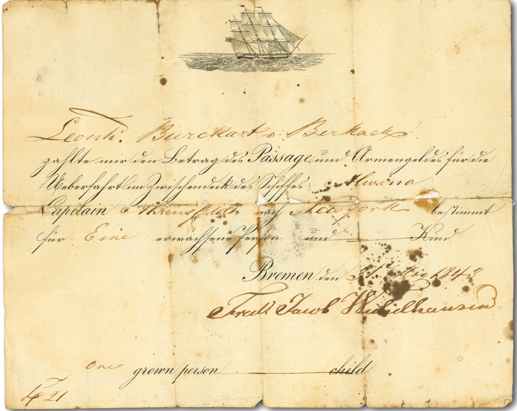
Between 1840 and 1858 seven of the nine living children of Johann Leonhard Burkhart immigrated to the United States from Birkach, Bavaria
Initially settling in and near Little Falls, New York, the first to arrive, Johann’s daughter, Margaret, met and married John Hem, a farmer and stonemason. From there, Barbara and John sent money back to Bavaria to, one-by-one, bring six of her siblings across the Atlantic to join her.
Not finding New York to their liking, however, the growing German immigrant extended family looked west to Illinois where they heard rich land was available at affordable prices. So during the winter of 1843-44, a 12-member family group of Hems, Burkharts, Haags, and Fausts headed west to Chicago.
Georg Leonhard Burkhart’s 1843 sailing ticket to the U.S. English translation: Leonhard Burkhart, Birkach has paid the fare for passage and accompanying baggage in the middle deck on the ocean crossing aboard the ship Alwina under Captain Krensfeld for New York only for one adult and child [with space for number of accompanying child/ children lined through] Bremen, May 31, 1843. Fried. Jacob Hichelhausen. (Little White School Museum collection)
Fast-growing, boisterous, muddy, swampy Chicago was definitely not what these immigrant German farmers were looking for, so they moved farther west, arriving in Kendall County’s Oswego Township in 1844. The families chose to claim land east of the growing village of Oswego along what is now known as Wolf’s Crossing Road on what was known locally as the Oswego Prairie. The Hems started with an 80-acre farm.
George Leonard and Anna Margaret Brunnemeyer Burkhart. (Little White School Museum collection)
Margaret’s younger brother, Georg Leonhard Burkhart—who quickly shortened his name to Leonard—soon bought his own 80-acre farm bordering the Hems’ to the north. Marrying Anna Margaret Brunnemeyer on Christmas Day, 1848 in Naperville, the young couple set out farming and raising a family. They were extraordinarily successful at both, being able to eventually gifting each of their eight children with their own farms or the monetary equivalent on their wedding days.
Their son, Leonard Frederick Burkhart, born on the family farm in 1859, but apparently grew up looking to be something more than just a farmer like the rest of his siblings. In 1881, he married Otilda Philopena Lang. Like Leonard’s parents, the couple turned their energy towards farming and building a family—but only briefly.
Because, as it turned out, Leonard Fred (as he was known), despite the farming that had been in their parents’ blood for generations, would also figure prominently in Oswego’s in-town business community, including giving the family name to one of Oswego’s most familiar commercial buildings.
Leonard Frederick and Otilda’s son, Oliver Andrew Burkhart, read law, became an attorney, was elected Kendall County State’s Attorney and was a federal court commissioner, as well as being the long-time Oswego Village Attorney. Along with that, he also invested in Oswego’s business community and became an early adopter of automotive technology—he was one of Oswego’s first automobile dealers.
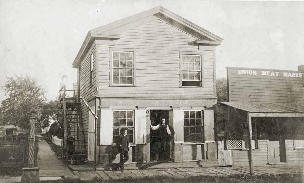
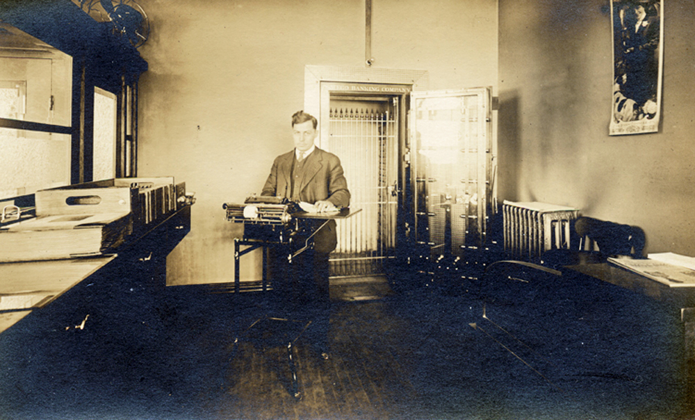
The Oswego Banking Company was established in the south storefront of the Schickler Block in 1904. (Little White School Museum collection)
Then in 1904, F.H. Earl and D.M. Jay of Plano announced plans to open a bank in Oswego. E.W. Bowman of the Bowman Bank in Kalamazoo, Michigan was also interested in the new firm, named the Oswego Banking Company. Floyd Phelps was hired to run the enterprise, which located in the Schickler Building at the northwest corner of Main and Washington streets in Oswego.
The new bank opened in January 1904.
During the summer of that same year, Leonard Fred Burkhart acquired the private bank, and installed his son, Oliver A. Burkhart as the banker replacing Phelps.
But the space in the Schickler building was limited and Leonard Fred had his eye on the lot kitty-corner from the bank’s location.
In January 1908, he bought what was known as “the Smith Corner” at the southeast corner of the Main and Washington intersection with the intent to build a new brick block to house the family’s bank as well as other businesses.
The storey and a half frame building that occupied the site was a venerable old structure dating back several decades. But to make room for his new commercial block, the old had to go.
To make way for his new brick commercial block, Leonard Fred Burkhart had to clear the corner site. By the time construction began only the Greek Revival frame building at the corner was still standing. (Little White School Museum collection)
As the Kendall County Record reported from Oswego on April 1, 1908: “Oswego village is to have a new bank and office building. It will be a brick block, situated on the corner where the electric cars turn to cross the trestle on the site formerly occupied by the waiting station. The old building has been torn down and with its razing one of the oldest landmarks of the village passes away. The new structure is being built by L.F. Burkhart, the Oswego banker; and the bank will be located in it, and the rest of the building will consist of offices for the professional men of Oswego.”
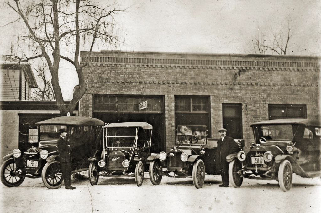
With construction underway, Leonard Fred began casting about for tenants, and instantly found one in his son, Oliver’s auto dealership partnership with his cousin, Charles Shoger. The pair had been selling autos to Oswego residents for some years, eventually dealing in cars manufactured by E.M.F., the Flanders (eventually bought out by Studebaker), Jackson, Empire, Olds, Carter, and Studebaker. A set of gasoline pumps was also considered for the future.
The completed Burkhart Block housed (left to right) the Burkhart & Shoger Garage, the Oswego State Bank, the Oswego Post Office, and the Oswego telephone exchange. This photo of the building was taken about 1913 by Dwight Young. Little White School Museum collection)
But with the auto dealership facing Washington Street and his bank in the corner suite with its unique corner doorway, Burkhart needed more businesses to fill out the block’s two storefronts that would face South Main Street. In business, timing is often the most crucial factor leading to success, and that was certainly the case with Burkhart’s new building.
The Burkhart & Shoger Garage, owned by Oliver A. Burkhart (left) and Charles Shoger (right) on Washington Street just east of Main, in 1914. Burkhart and Shoger were dealers for EMF and Studebaker autos with four new ones parked in front in this photo. Little White School Museum collection)
The Oswego Post Office, which had been located in the false-front frame building across the alley from the Union Block on the east side of Main Street since the 1870s, was becoming cramped and the postmaster was looking for a new home, one that Burkhart was happy to offer to him.
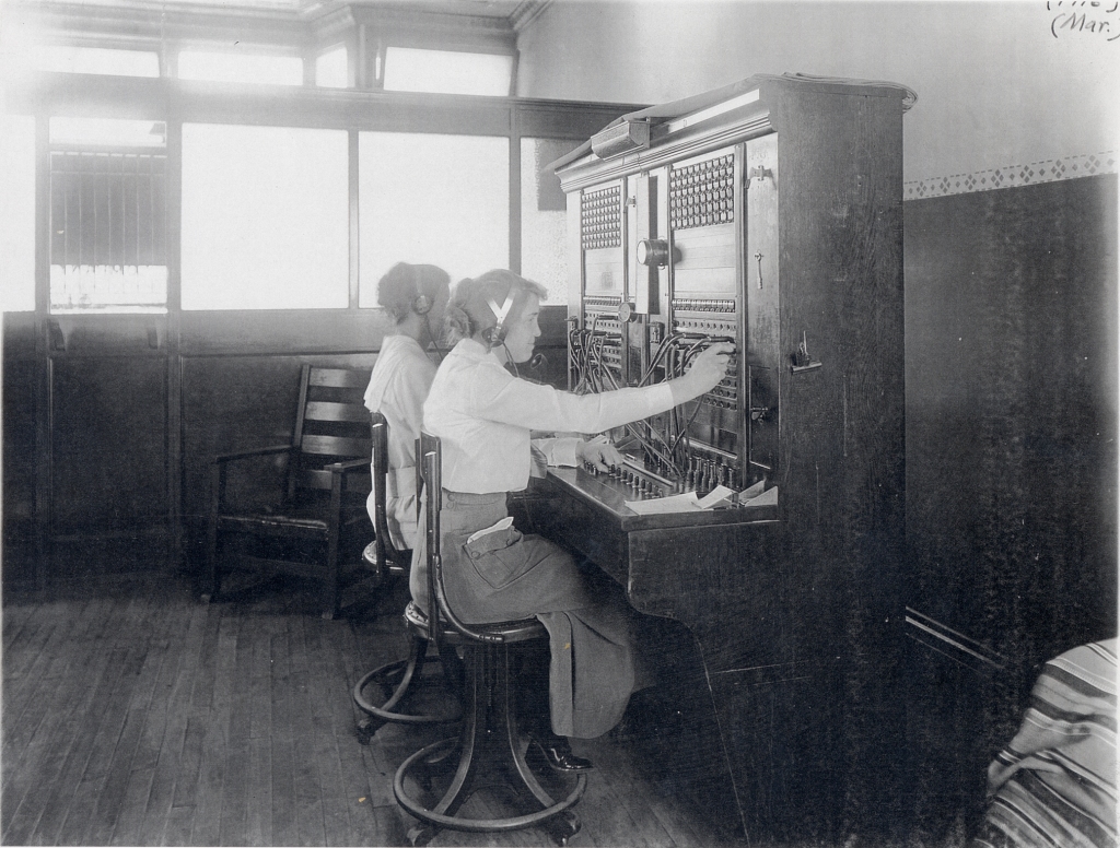
The Chicago Telephone Company’s new switchboard in the Burkhart Block in March 1911. Above, Orma Young Shoger connects a caller while Ina Huntoon handles other calls. (Little White School Museum collection)
Further, the Chicago Telephone Company’s Oswego switchboard (later Illinois Bell Telephone) had outgrown its home on the second floor above Cutter’s Drug Store and was looking for a new, larger, location. Burkhart suggested he had just the spot for them, and they quickly took him up on the idea.
By the end of January 1912, all the businesses had moved into the new Burkhart Block, where they were all slated to remain for the next several decades—with a few changes.
Oliver’s brother, Clinton, joined the banking business early on, and continued as the bank president for many years. He was also elected Oswego Village President for several terms. He continued with the bank until it closed due to the combined effects of the Great Depression and a daring 1932 daylight robbery. After the Oswego State Bank was forced to close, Oswego didn’t become home to another bank until the Oswego Community Bank was established in 1958.
Interior shot of the Oswego State Bank, probably taken in 1913 shortly after it opened at the corner of Main and Washington streets. (Mark Harrington collection)
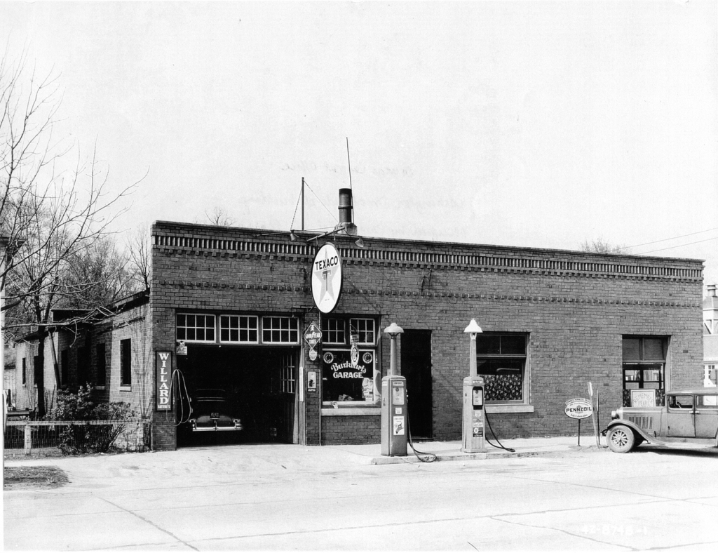
In 1925, Oliver Burkhart’s younger brother, Ralph M. “Burkie” Burkhart, bought the car business, renaming it the R.M. Burkhart Garage. He became a Pontiac dealer in 1934 and operated the business there until he retired in 1971, selling the business to Jim Detzler, who maintained the “Ugly Little Showroom” until moving out of downtown to larger quarters at Zero Boulder Hill Pass. When Detzler assumed ownership of the dealership, it was the first time since the Burkhart Block was built that a Burkhart wasn’t involved in a business located in it.
The Oswego Post Office continued in the Burkhart Block until the Postmaster George Bartholomew decided to move it to larger quarters in the Schickler Block across the intersection due to the community’s accelerating population growth. The facility moved in late March 1958 and remained there for a decade until Oswego’s “new” post office—the current, badly cramped facility at Madison and Jackson—opened in 1969.
Burkhart’s Garage, with gas pumps, during World War II in 1942. (Little White School Museum collection)
And while Illinois Bell’s old Oswego switchboard was replaced by automatic dial equipment in 1939, the storefront they occupied in 1911 continued to be their Oswego home until 1969 when the new automated switching station opened at Washington Street and Ill. Route 71. In 1971, the new facility allowed Illinois Bell’s Oswego customers to be the first in Illinois to receive speed dialing, conference calling, call forwarding, and call waiting services.
The Burkhart Block, with businesses (left to right) Burkhart Pontiac, the Kopper Kettle, the Jacqueline Shop, and Illinois Bell Telephone’s switching station. Photo by Homer Durand in the collections of the Little White School Museum.
With the departure of its core occupants, the Burkhart Block became the home of many other enterprises over the years. For instance, the old post office storefront became the location of the first Jacqueline Shop women’s clothing store when Jackie and Ken Pickerill opened it in 1957. The upscale store moved to the historic A.O. Parke Building at Main and Jackson in 1960.
Other businesses in the Burkhart Block have ranged through the years from the Kopper Kettle restaurant to the Elmer Fudge candy store to the Booze Bin liquor store. Today, the building is still a popular location for a variety of retail businesses.
Several years ago while doing family history research, I made connections with a distant cousin who sent me a compact disc (remember those?) with dozens of photos and documents related to my Minnich ancestors. Among the documents were letters written by my great-great-grandmother, Mary Ann Wolf “Polly” Minnich, to her daughter, who was then living out in Kansas.
Mary Ann Wolf “Polly” Minnich from what was probably her 1846 wedding portrait.
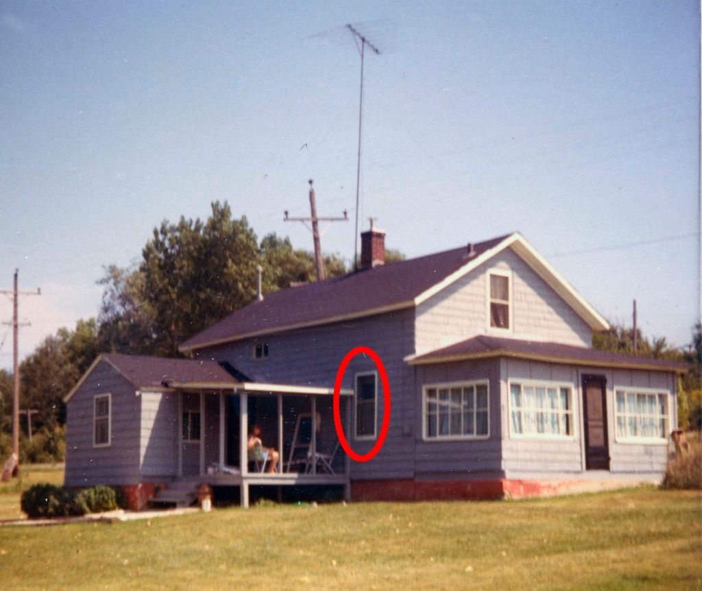
The letters were remarkable for a few reasons, not the least of which was because Mary Ann was illiterate. According to the letters’ content, she dictated them to one of her grandchildren, who wrote and mailed them for her and who would then also read the replies to her. Another interesting point, for me, at least, was that at the time she was corresponding with her daughter, she was living in the ramshackle old house on North Adams Street in Oswego that was the first house my wife and I bought back in 1968.
The previous owners were the first non-family members to have owned it since my great-great grandparents owned it in the 1870s. We lived there for about 10 years, and so I was familiar with its interior layout. My grandmother, who as a child had visited HER grandmother at the house told us about the interior changes that had been made, including turning my great-great grandparents’ tiny first-floor bedroom into the home’s bathroom. Which is why the bathroom had a full-sized window in it above the bathtub that looked out onto North Adams Street and the east bank of the Fox River across the road.
The Minnich House as it looked in 1970 with Mary Ann’s bedroom window facing North Adams Street and the Fox River circled in red.
By the time we moved in back in ’68, trees lined both banks of the river, cutting off the view of Route 31 over on the river’s west side. But back when my great-great-grandparents lived there, the original old-growth trees on both banks had been cut down years before to provide everything from fence rails to firewood to building materials for homes and other buildings the pioneers needed. So someone looking out of the window in our bathroom—formerly my great-great-grandparents’ tiny bedroom—could easily have seen traffic over on Route 31, known back in the late 19th and early 20th centuries as the West River Road.
Which is a long, but I think necessary set-up for a fascinating comment I found in one of those letters long ago transcribed from my great-great-grandmother’s dictation.
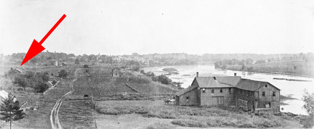
North Adams Street about 1910 with the arrow pointing out my great-great-grandparents’ house, and illustrating the treeless banks of the Fox River during that era. The building at right foreground is the Parker Sawmill and Furniture Factory. (Photo by Irvin Haines in the collections of the Little White School Museum)
By late September 1900 residents living in and around Oswego, including those living along North Adams Street, had some new sights to see and marvel at. As my great-great-grandmother put it in one of those letters to her daughter out in Kansas: “When I can’t sleep at night I can watch the Street cars run out my window over across the river.”
She could see the headlights of streetcars running on the west bank of the Fox River in 1900? Yes, as it turns out, there was, indeed, a trolley car line that ran from Aurora south roughly following the Fox River to Oswego that began service that year.
This contemporary map illustrates the route of the interurban trolley line from downtown Aurora south through Oswego into downtown Yorkville where it terminated at Van Emmon and Bridge streets. (Little White School Museum collection)
Because this kind of trolley line ran between towns and not wholly inside them, the lines were called “interurban” trolleys, and were at the height of their popularity as the 20th Century dawned.
A group of investors first proposed building an interurban trolley line from Aurora south through Montgomery and Oswego to Yorkville in 1897. The proposed line was planned to run mostly on public street and highway rights-of-way using light rails and electrically-powered trolley cars.
First iron bridge across the Fox River at Oswego. A King’s Patent tied-arch (also called a bowstring arch) truss iron bridge, it was built by Oswego Township in the fall of 1867 at a cost of $17,000. The bridge was manufactured by the King Iron Bridge & Manufacturing Company of Cleveland, Ohio. It was replaced in 1900 to carry the tracks of the Elgin, Aurora & Yorkville interurban tracks across the river. (Little White School Museum collection)
An early proposal to build a third-rail electric line was quickly discarded in favor of using overhead electrical lines with the cars picking up the power using car-top trolleys. Cars running on third-rail lines picked up their electrical power from an exposed electrified third rail, something that would obviously be dangerous on a rail line running through towns and the countryside and not in an underground tunnel or on an elevated track safely out of reach of pedestrians, horse-drawn vehicles, and livestock.
In August 1897 representatives of the new Aurora, Yorkville & Morris Electric Railroad company (the line’s name would change several times during the next few years) met with the Kendall County Board to start hammering out a trolley franchise agreement. As proposed, the line would begin in downtown Aurora, then run south on River Street through Montgomery, paralleling the Fox River past the new Riverview amusement park (which was to have its own station) then under construction just south of Montgomery before gently curving west to join the West River Road—now, as noted above, Ill. Route 31—for the run to the Oswego Bridge across the Fox River. There, the line would turn east, cross the river on Washington Street to Oswego’s Main Street, where it would turn south once more, following Main Street and heading towards Yorkville along what is now Ill. Route 71. Near Yorkville, the line would turn once again to follow the tracks of the Chicago, Burlington & Quincy’s Fox River Branch Line between the tracks and today’s Van Emmon Road right into downtown Yorkville, where the tracks dead-ended at Van Emmon and Bridge streets.
The box truss iron bridge built with trolley company assistance in 1900 to carry interurban cars across the Fox River at Oswego. It replaced the first iron bridge at Oswego built in 1867, and was itself replaced in 1937 to carry increasing motor traffic across the river. (Photo by Dwight Young in the collections of the Little White School Museum)
Among the issues that had to be hammered out was who would pay for improvements the line required, such as either strengthening or rebuilding the Oswego Bridge to carry the heavy trolley cars across the river. In addition, the company pledged “that in every way possible the company would guard against frightening horses” or otherwise interfering with traffic on the roads alongside and on which the trolleys would run. In the end, the trolley company agreed to pay $3,500 towards the cost of a new, stronger box truss iron bridge to replace the existing 1867 tied arch structure at Oswego. The other issues were ironed out as well, including how the trolley line would get across the Chicago, Burlington & Quincy’s Fox River Branch rail line in Oswego.
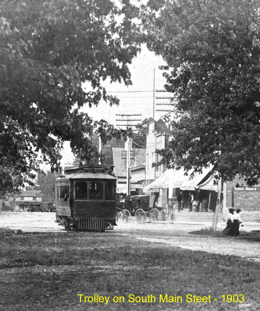
Interurban trolley car (center of the photo) approaches the west end of the Oswego Bridge about 1903 enroute from Aurora to Yorkville. The tracks crossed the Fox River on the Oswego bridge and then turned south along Main Street.
Residents of the towns the trolley would serve were, in general, enthusiastic about the new, all-weather transportation option. As Kendall County Record Publisher John R. Marshall noted in a Dec. 13, 1899 commentary: “With only four reliable trains a day, it was hard for one to come here and be so late getting into Chicago as is necessary with the regular passenger train. With the electric accommodations, one can go to Aurora and take an early morning train to Chicago.”
After crossing the Oswego Bridge, the interurban line climbed the Washington Street hill and crossed the CB&Q Railroad tracks on a 300-foot timber trestle. (Little White School Museum collection)
Construction began in the spring of 1900 and by June 27, the tracks were completed from Aurora to the west end of the Oswego Bridge.
“Operation of the electric road from the bridge will be commenced this Tuesday afternoon by a free ride of the town and village officials to Aurora and back,” the Record’s Oswego correspondent wrote in that week’s paper. “Yorkville will have to wait about three months longer before enjoying such privilege.”
This 1903 map shows the interurban route through Oswego. Look closely in the lower left at the siding at the Oswego Cemetery. Special funeral cars that carried mourners to this cemetery and farther south, to the Cowdrey Cemetery used this siding and the one at Cowdrey for funerals. (Little White School Museum collection)
Regular service began in early July from Aurora to the terminus at Oswego, and use proved enthusiastic—and frequent. As Marshall wrote on Aug. 1: “That the Aurora and Yorkville electric road will be a great convenience and daily comfort is shown by the way it is used now between Oswego and Aurora. Every day parties drive up from about here [Yorkville] to Oswego and take the car there for Aurora, saving 12 miles’ [round trip] drive.”
Work continued feverishly the rest of the summer and into the fall of 1900 on Oswego Township’s new Oswego Bridge. Construction was also ongoing on an impressive 300-foot trestle at the east end of the bridge designed to carry the electric line up Washington Street over the CB&Q tracks to the Main Street intersection.
By late December, the new bridge and trestle, along with the tracks into Yorkville were finished and regular trolley service had begun, linking downtown Aurora through Montgomery and Oswego with downtown Yorkville. The first car arrived at the Kendall County seat at 10:45 a.m. Saturday, Dec. 22, 1900.
“There were two cars down—one with the Aurora guests, the other empty to return with a number of the distinguished populace of Kendall’s capital,” the Record reported on Dec. 26. Welcoming the new arrivals was Record publisher Marshall, who had also welcomed the first railroad train on the Fox River Branch into Yorkville 30 years before.
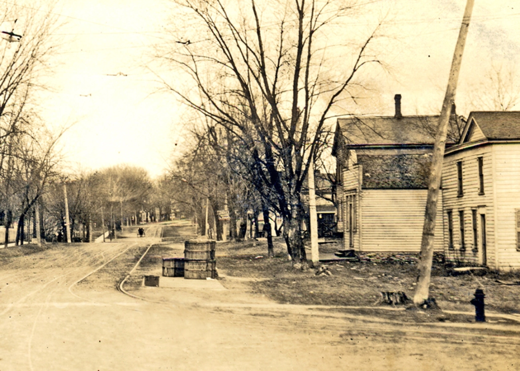
At Washington and Main streets, the trolley line turned south to follow Main out of town. This was also the village’s trolley stop, with a waiting room in the building at right just behind the fire hydrant. Note the stack of wooden bread crates. Fresh bread from Aurora bakeries was delivered early every morning. The Little White School Museum has two in its collection, including on on exhibit that was repurposed as the village’s ballot box. (Little White School Museum collection)
The interurban, providing hourly round trip service from Yorkville to Aurora from 7 a.m. until 11 p.m. at affordable rates, was part of a vast interurban network that, it was said, allowed passengers to travel via trolley from the Mississippi River, with transfers, all the way to New York City.
Note the two passengers who’ve just stepped off the interurban, likely after a shopping trip to downtown Aurora. (Little White School Museum collection)
In an era of terrible roads, the interurban was a godsend, carrying passengers and perishable freight, including farmers’ milk, to and from Aurora. Everything from fresh bakery bread to college and high school students to office workers to shoppers rode the trolley to and from Aurora daily. For instance, war hero, musician, and star athlete Slade Cutter rode the interurban to Aurora to attend East High School. The line ran right past the family farmhouse (which still stands at the corner of Ill. Route 17 and Orchard Road) during a time Oswego High School only offered a two-year program.
Motor vehicles shared in-town streets with the interurban lines, making driving on them often an adventure. Here, an auto rattles south on still unpaved Main Street about 1910 in Oswego while sharing the road with the trolley tracks. (Little White School Museum collection)
But a little more than a decade after the line opened, it and others throughout the nation were under financial assault from the burgeoning number of automobiles and trucks—and government support for them.
It wasn’t so much the improved vehicles that doomed the trolleys, but the rapidly improving roads they traveled on—and their funding. From the time Illinois was settled until 1913, road maintenance was the responsibility of township property owners. Each voter—meaning men during that era—was required to work on road maintenance or to pay money in lieu of work. But with the advent of affordable, dependable motor cars and trucks, the old system was proving unequal to the task of road maintenance and construction. So in 1913, the Illinois General Assembly passed the Tice Act, removing the work requirement and replacing it with a property tax levy to fund road construction and maintenance.
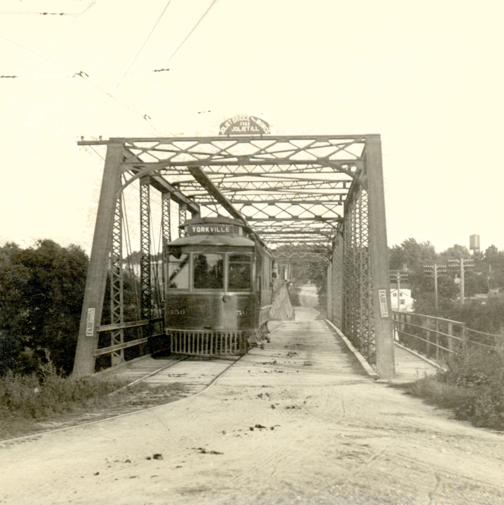
An interurban car at the terminal in downtown Yorkville. It’s been turned around on the trolley line’s wye track and is ready to head back north through Oswego and Montgomery to Aurora. Note the advertisement for the Kendall County Fair. (Little White School Museum collection)
At the same time, the public was also insisting on more and better roads, and in what proved a momentous policy decision, U.S. politicians decided that tax dollars should only fund construction and maintenance of roads and not the rails used by railroads and trolley companies. Although few realized it at the time, the policy meant the substantial government subsidy favoring road transport would gradually result in curtailing all of the nation’s rail systems.
Interurban trolley ticket for a passenger fare from Aurora to Oswego from 1918. Note the “War Tax” schedule in the upper left. The tax was levied by the Federal government to help pay for World War I. (Little White School Museum collection)
And with that profound change in motion, in 1918, in spite of the nation’s involvement in World War I, Illinois voters approved a $60 million bond issue to build a system of all-weather paved roads to connect with every county in the state, the bonded indebtedness to be paid through gasoline taxes. The measure passed overwhelmingly. Here in Kendall County, the vote was 1,532-90.
A new iron bridge crossed the Fox at Oswego in 1900 to carry interurban trolley cars across the river, along with regular road traffic. Above, a trolley car is captured on its way from Yorkville to Aurora. (Little White School Museum collections)
The interurbans were simply unable to compete with the combination of increasingly inexpensive, efficient, and dependable motor vehicles and publicly financed roads. Starting in the 1920s, one by one, the interurban lines closed down, went bankrupt, or both.
On Aug. 6, 1924, the Record reported that “Through an order from the Illinois Commerce Commission, the interurban line from the [Fox River] park south of Montgomery to Yorkville will be discontinued.” In the event, the line carried on until Feb. 1, 1925, finally succumbing to the advance of transportation technology and the national consensus to subsidize roads but not rails.
Today, there are scant reminders of the trolley era, but look closely between the road and the railroad tracks the next time you drive Van Emmon Road into Yorkville—especially this time of year with trees and shrubs leafless—and you will see some of the last evidence of the old trolley line that was once such an important part of the area’s transportation system.
Last month, Nancy Harvey Heaton donated a photo of the old Oswego Depot to the Little White School Museum. The framed photo had hung in her parents home starting some 50 years ago when she was a youngster.
Photo of the Oswego Chicago, Burlington & Quincy Railroad depot, apparently taken shortly before it was demolished despite local efforts to preserve it. Donated to the Little White School Museum by Nancy Harvey Heaton.
The image, captured by the LIN DON Studio back about 1971, showed the depot in its waning years. And it prompted me to begin looking into what happened to that once-familiar landmark. I recalled there had been efforts to save the building and turn it into a community museum back in the early ‘70s, but I couldn’t remember when the railroad had actually demolished it. I also recalled the loss of the depot spurred community residents to become aware that, as growth was accelerating, Oswego was losing a lot of its heritage. In fact, the loss of the depot was one of the things that prompted the formation of the grassroots Oswegoland Heritage Association in 1976 to save the iconic Little White School from demolition.
Oddly enough, the depot’s demolition didn’t seem to be a big issue in the local press back then, as another search of the microfilm confirmed. So I decided to do some deep diving to get the depot’s story recorded before any more time was lost.
To do that, I started at the very beginning when the Aurora Branch Railroad from Aurora through Batavia to Turner Junction–later renamed West Chicago–was chartered by the Illinois General Assembly in 1848. At the Junction, the Aurora Branch connected with the Galena and Chicago Union Railroad that ran from Chicago to Galena. In 1852, the two lines merged and were given permission to cross the Fox River and build a line west to Mendota.
Fragment of a $5 scrip note from the Oswego & Indiana Plank Road Company issued by the firm of Rawdon, Wright, Hatch & Edson in 1852. (Little White School Museum collection)
The question was where to cross the Fox. The company favored Oswego because the river is at its narrowest point there, but Oswego officials were opposed.
Even though the railroad’s officials suggested manufacturing and repair shops would likely be located at Oswego, something that would result insignificant economic growth, not to mention the easy access to the nation’s growing rail network for passenger and freight traffic, village officials refused.
Oswego’s political power structure at the time was heavily invested in transportation by horse. That extensive infrastructure included blacksmiths, harness makers, wagonwrights, wheelwrights, livestock feed suppliers, and horse breeders. The plank road–a road paved with thick wooden planks–would be an all-weather route that would use existing horse-drawn transportation technology. A railroad, being completely different technology would not.
Railroad officials were so sure Oswego would jump at the chance for a rail link in 1850 that they announced that’s where the line would cross the Fox River, as shown on the “Rail Road and County Map of Illinois Showing its Internal Improvements 1854,” published in New York by Ensign, Bridgman & Fanning, New York. The blue highlight marks the planned route. (Library of Congress collection)
An anonymous author, writing under the pen name “Plow Boy” in the Sept. 5, 1855 Kendall County Courier, published in Oswego, explained: “In 1850, a [rail] road was commenced from the Junction to Aurora, thereby connecting with Chicago. A committee of agents of the railroad company waited upon the citizens of Oswego, and solicited their cooperation in extending the road to Oswego. But they were met with insults. They were told that Oswego could do favorably enough without a railroad. That a plank road was the thing that would throw railroads in the shade, and monopolize the whole business of transportation. The consequence was that Oswego was without either railroads or plank roads. Aurora was for many years the terminus of the road, and a central market place for the whole surrounding country. These are facts, which have come under our observation. The leading businessmen of Oswego were at first, generally opposed to the project of railroads. Thus, as the event has proved, cutting their own throats.”
Aurora officials were not at all opposed, however, so even though the river was much wider there the rails crossed at that fast-growing city, the shops and roundhouse were built there, and the line completely bypassed Oswego two miles to the west.
And in the end, of course, the plank road, other than a few miles that briefly linked Plainfield and Joliet, never happened.
The CB&Q’s mainline ended up crossing the Fox River at Aurora and bypassed Oswego two miles to the west. The railroad did establish Oswego Station, with passenger and freight depots to serve the community, but that required a ride in a horse-drawn coach to get to the rail line. This 1870 map shows both the railroad’s mainline and the new Ottawa, Oswego & Fox River Valley Rail Road right-of-way through Oswego. (Little White School Museum collection)
Oswego did get a station on the main line as did the Village of Bristol just down the river. A small town grew up around Bristol Station while passenger and freight depots and two lumberyards were built at Oswego Station. But no town ever grew up there. Instead, regular horsedrawn stage service linked the station with downtown Oswego.
Then in February 1855, the Galena and Chicago Union Railroad and the Mississippi and Rock River Junction Railroad merged, with the new firm renamed the Chicago, Burlington & Quincy (CB&Q) Railroad.
After the plank road fiasco, it took a while for Oswego to finally get its direct rail link. Not until after the Civil War was a rail line built through the village, the tracks of the Ottawa, Oswego, & Fox River Valley Rail Road reaching Oswego in 1870. The line was mainly built to connect the coal fields around the Vermillion River with towns from the rail junction at Streator up the Fox River from Ottawa through Yorkville and Oswego to Geneva. But another major reason was to break the CB&Q’s Kendall County freight monopoly. In the end, that didn’t work, something you can read more about here.
But nevertheless, the new rail link was welcomed. And as soon as the line was built, a depot had to be located at each town along the line. And In Oswego the debate about where to locate its depot was spirited.
The 1885 Sanborn Fire Insurance Map of Oswego shows the location picked for the Oswego Depot (circled in red) on Jackson Street near the intersection with South Adams. (Little White School Museum collection)
As Lorenzo Rank, the Kendall County Record’s correspondent, reported on Oct. 13, 1870: “It was last Thursday that the locomotive first made its appearance in our town; the cows stared at it and so did everybody else. The event transpired without any unusual noise or commotion, there was no gunpowder burned and nobody tore his garments in consequence of it. There is now a three-cornered contest about the location of the depot, one party wants it south of Washington St., another north of it, and still another wants it on the other side of the Waubonsie. The southern location to my mind is the best; the central and the most convenient for the present business community and the one that likely will be adopted; it is proposed that if the latter is chosen, to open from Main street and avenue to it by removing the Sherwood and Cooke buildings, which lots in connection with the alley would make a good thoroughfare to the depot.”
By Nov. 3, the debate was still ongoing. “The location of the depot is now the most exciting topic on the carpet; the uptown men have decidedly the start; they have Chapman on their side, who was very busy yesterday raising money for that purpose,” he reported.
The Oswego CB&Q Depot as it looked about 1881. The original 1870 depot building is on the left, with the 1871 addition on the right side. Stationmaster Henry Green Smith is standing at left in his shirtsleeves. Smith was appointed stationmaster at Oswego in May 1880. (Little White School Museum collection)
In early December, the question was finally settled. As Rank reported on Dec. 8: “The depot question is settled—the grounds staked out immediately above Washington St.; there seems to be not much else going on now on the road but graveling.”
With its own rail connection, Oswego Station two miles west of town was no longer needed. The old freight depot at Oswego Station was dismantled in April 1871 and the abandoned passenger depot at the station burned to the ground in August 1879.
In July 1871, the original Oswego Depot building was enlarged with an addition shipped in by rail. According to Rank: “The railroad company has lengthened the side track, put in new switches, also additional stringers on the Waubonsie bridge with new and heavy ties, and otherwise much improving the track hereabouts; an additional depot building was also shipped here yesterday.”
In November of that same year, Henry Wollenweber built a livestock loading chute just south of the depot between a new siding and North Adams Street. Soon after, Wollenweber and Rudolph Knapp began a lively livestock business, with cattle and hogs driven to town by area farmers. The stock was kept in pens between North Adams as the Fox River before being driven across the street to the loading chute. Eventually, holding pens were added just north of the loading chute.
In October 1873, a milk and cream shipping platform was added just north of the depot on the same side of the tracks.
The depot started out as a busy place and it’s business continued to grow. On Jan. 13, 1881, Rank reported that: “The total receipts from all sources at the depot during 1880 were $27,000; total number of cars received and forwarded 932; cars of ice shipped 581; 401 cars include stock, grain, coal, lumber, feed, wheat, cotton, granite and tile; there were 5,073 passenger tickets sold; 5,785 cans of milk were shipped, mostly by W.H. McConnell & Co.; M.J. Poage & Co. received 94 cars of coal and 72 of lumber; Wollenweber & Knapp shipped 108 cars of stock; Wm. Parker & Son received 6 cars of wheat and 2,500 pounds of fire and burglar proof safe..”
The Oswego Depot, probably taken in 1890, after the depot was significantly enlarged and remodeled in the summer of 1886. The block signal tower was added in October of 1889, according to the Kendall County Record of Oct. 2, 1889. Station master Henry Green Smith is standing fifth from left. It is believed several of the other persons in the photo are members of Smith’s extended family. (Little White School Museum collection)
In July 1886, Rank reported the original depot was undergoing considerable renovation. On Sept. 1, he wrote that: “The depot has been fixed up very handsomely; the new office probably will be occupied, and the waiting parlor thrown open to the public today. The business of late has been transacted in the freight room.”
This winter view of the depot features Stationmaster Smith seated on the south end of the building, with two young visitors sitting to his left. The livestock loading chute is visible to the left of the stock car on the siding at left and the milk and cream shipping platform is just across the tracks from the livestock siding. The image also offers a good view of the signal tower added in 1889. (Little White School Museum collection)
Three years later, the depot was upgraded with a new safety feature, a block signal that could be operated from inside the building in the bay window facing the tracks. Yorkville’s depot was outfitted with one at the same time. Record Editor J.R. Marshall explained how the system worked: “It is quite an imposing machine. A long wooden box or tube 20 or 30 feet high runs from the office floor above the roof of the station; on this are signal arms, green and red, worked by levers in the office; also lamps which are raised and lowered in the tube by a crank and chain in the office. The signals made above are repeated before the operator in the office, and a mirror, slantwise, at the bottom of the tube, shows that the lamps are burning all right.”
The 1898 Sanborn Fire Insurance Map shows the Wollenweber & Knapp Stockyard on the northwest side of the tracks at the northeast corner of the Adams and Jackson Street intersection and its relation to the Oswego Depot. (Little White School Museum collection)
With so much fascinating stuff happening around the depot, you might think the hubbub created an attractive nuisance—and you’d be right. Especially attracted were what Rank called “the small boys,” who just couldn’t stay away. On Oct. 22, 1890 he wrote: “There is a good deal of complaint just now about the small boy. He is charged with jumping on moving trains and otherwise raising Cain around the depot; with being saucy, using very profane language and not going to school. The small boy seems to have the upper hand of many of the parents.”
The Oswego Stockyard looking north from Jackson Street towards the bridge across Waubonsie Creek. photo was taken from Jackson Street looking north along North Adams Street, and the old feed mill, later a home on the north side of the creek is visible just to the right—upstream—from the bridge. (Little White School Museum collection)
Along with being a transportation center for Oswego, the depot was also an important communications center. The depot’s telegraph station not only sent and received railroad information, but also messages sent and received by the public. And that provided new opportunities for women. In the 1890s, the first female telegraphers were noted at the depot. In addition, women were also acting as station agents. Auroran Jennie Miller filled in frequently for Oswego Station Agent Henry G. Smith as temporary agent and telegrapher.
The Dinky pulls out of the Oswego Depot in 1942 headed southbound to Yorkville, Ottawa, and Streator. The CB&Q’s gas-electric car provided passenger, mail, and freight service on the Fox River Branch Line until it was discontinued in 1952. (Little White School Museum collection)
While freight service, particularly grain and lumber, remained strong for many years, the passenger traffic through the depot began a sharp decline as better roads and more economical and dependable autos and buses were developed. In the 1930s, the CB&Q began running a combination freight, mail, and passenger gas-electric car—nicknamed the Dinky by residents along the line—from Streator to Aurora, providing passenger service for towns and villages along the line. But in February 1952 that service was also dropped and the Oswego Depot began exclusively handling freight. The Dinky’s place was taken by bus service paralleling the rail line.
By the time this northbound CB&Q freight train passed the Oswego Depot in 1965, the depot was only handling a fraction of the business it once did. (Little White School Museum collection)
While there were no more livestock yards at Oswego by the 1950s, the village’s sidings still handled carloads of lumber for the Alexander Lumber Company and grain shipments from the Oswego Grain Elevator.
But that relatively small amount of business didn’t require a dedicated depot at Oswego and in the spring of 1970, the CB&Q closed the depot.
With its closure, some Oswego groups began looking to possibly save the building, in particular, the Oswego Woman’s Civic Club and the Oswego Jaycees expressed interest in turning the building into a community museum. The problem was that the railroad insisted the building had to be moved off railroad property.
By the late 1960s, the Oswego Depot was in poor repair and the railroad was discussing plans to demolish it. (Little White School Museum collection)
The Oswego Ledger reported on June 17, 1971: “The Oswegoland Jaycees, through the auspices of the Burlington Northern Railroad, have been given the ‘Oswego Railroad Station’ for purposes of turning it into an historical museum and landmark for the Village. It would be stocked with many artifacts relating to the history of Oswego in an attempt to retain our heritage for our youth. The railroad has told the Jaycees that the depot has to be moved from its present location or be torn down. The Jaycees are going to undertake this project, including all costs of moving and renovating. They do need, however, a site to which to move the building. The site they wish to use is a parcel of Township property located behind the new post office. Upon completion of the move and remodeling operation, the edifice would be donated to the village through the park board, who has agreed to care for the museum. Area residents will then be free to place any articles of an historical nature on display for the public school children to view.”
Although efforts were ongoing to save the old depot and turn it into a community museum, the railroad surprised the community in the spring of 1972 by contracting to have the building dismantled. This photo was taken by Oswegoan Don Crimmin on April 9, 1972 at the railroad’s contractor worked to dismantle the depot. (Little White School Museum collection)
But as the search for a site went on, the railroad apparently lost patience and in April of 1972 a contractor hired by the CB&Q dismantled the building, removing a tangible reminder of more than 100 years of Oswego’s transportation history and heritage to an end.
Copy of a Paul Randall watercolor of the Oswego Depot framed with scraps of wood and square nails recovered when the building was being dismantled. This originally hung on the wall of my mother’s house.
But, as noted above, the loss of the depot prompted Oswego residents to begin taking the loss of the village’s architectural heritage more seriously. That feeling, plus the new appreciation of local history encouraged by the nationwide celebration of the United States’ 200th birthday in 1976, prompted a group of citizens to establish the non-profit Oswegoland Heritage Association. The Oswego School District had recently announced plans to sell or demolish the landmark Little White School, built at Polk and Jackson streets in 1850 as a Methodist-Episcopal Church. The last classes had been held there in the mid-1960s, after which the building had been allowed to deteriorate. But with the enthusiasm created by the nation’s Bicentennial, an innovative three-way agreement between the new heritage association, the school district, and the Oswegoland Park District was hammered out to save and restore the building and open a local history museum and archives there. The local history museum opened in 1983, the archives and research area followed in the late 1990s, and the building’s restoration was completed in 2002. (Read about the restoration of the Little White School here and here)
So despite its unfortunate loss, the destruction of the Oswego Depot nevertheless led to saving irreplaceable community historical resources for future generations just as explosive population growth was forever changing the Oswego area’s character.
One of the things that fascinates me about local history is the number of once-thriving major businesses that not only no longer exist, but of which barely any evidence of their existence remains.
Looking out my window at the couple inches of snow on the ground here at History Central this morning reminds me of another industry of which no trace remains. The ice harvesting business employed dozens of men every winter and was big business. For decades, thick ice was cut above the dams that dotted the Fox River, stored in giant icehouses, and hauled to market in rail cars. The industry’s rise and fall makes for an interesting bit of local economic history.
In 1870, when the Ottawa, Oswego, and Fox River Railroad finally reached Aurora, running from Streator and Ottawa through Oswego and Yorkville, residents in both Oswego and Yorkville had hopes its economic impact would be significant. And their hopes were realized.
Chicago, Burlington & Quincy Railroad locomotive and passenger cars, about 1870.
As soon as the rail line opened, farmers began shipping livestock and grain from stops along the line north to the Chicago market and south to the Illinois-Mississippi river system. The new line was closer to almost all the Fox Valley’s smaller towns south of Aurora than the main line of the Chicago Burlington & Quincy Railroad, which lay two miles west of both Oswego and Yorkville. And farmers living east of the Fox River no longer had to cross the river to get their livestock, grain, and other produce to market.
Not only did the line haul produce and livestock to the Chicago market but it also delivered coal, lumber, and other necessities, reducing the costs of both vital commodities.
Entrepreneurs began eying the two villages for new business opportunities as soon as the first trains rolled. And as luck would have it, the new retail ice business was then just getting off the ground as growing numbers of householders demanded ice for their new kitchen ice boxes. At the same time, Chicago pork and beef packers were trying to expand production outside their normal winter work season.
One of the main uses for ice from Oswego, Yorkville, and other Fox Valley towns was in reefer cars invented by the Swift Company. It took 4,000 lbs. of ice and 700 lbs. of salt to keep a carload of dressed beef and pork cool from Chicago to New York…
For decades, ice had been harvested in New England and sold as far abroad as India. But it was what economic historian William Cronon calls a large-bulk, low-value commodity. With the terrible roads of the era, it was expensive to haul large quantities of ice to market. So in New England ice was harvested on rivers and ponds close to seaports where it could be easily shipped. Out here in the Midwest, ice was harvested on lakes, ponds and rivers near rail lines, but that production quickly proved inadequate, especially for the meat shipping market—it took 4,000 pounds of ice and 700 pounds of salt to keep a reefer railcar of dressed beef cold from Chicago to New York—and ice dealers started looking farther and farther afield.
When the Fox River Branch of the CB&Q was opened, serving as it did towns up and down the river valley, most with dams and mills, ice company owners saw an opportunity. The first to take advantage of the combination of the new rail line and the untapped resource of mill dams in Kendall County was the Caledonia Ice Company of Chicago. Owner Robert Hutchinson began work on a major ice storage facility in Yorkville in the fall of 1872, just two years after the rail line opened. Hutchinson situated the new facility on land along the south bank of the Fox, leased from Jacob and Elias Black, owners of the Paris Paper, Grist & Saw Mills, just upstream from the dam. Workers finished a block of four interconnected ice houses, 20 feet high and the group measuring a total of 100×100 feet, in time for the winter ice harvest. The CB&Q, owners of the Fox River Branch line, built a new siding for the ice company’s use.
Hutchinson’s Yorkville Ice Company sold ice harvested on the Fox River in Chicago.
As the Kendall County Record reported on Oct. 24, 1872: “The [ice] cakes are cut 22 inches square…the ice will be cut by ice plows, of which five will be used, each drawn by a horse. About 30 men will be employed through the winter and four to five in the summer. The company expects to ship three carloads, or 30 tons, to Chicago every night during the summer in cars fitted for the purpose.”
How did the process of harvesting ice from the Fox River work? As the Record explained about the ice harvest in an 1872 story: “It will be taken from the river by a new style of elevator never before used in the West, consisting of a heavy endless chain running over two large iron pulleys weighing 1,100 lbs., and propelled by a steam engine. This chain carries a series of hooks that, as they revolve, grab a cake of ice from the river and carry it up the elevator in grooves that act like a railroad track, to its proper platform, where it is received by a man who pushes it along the track to the door at which it is to be received These tracks on each platform, have “switches” at each door, and by turning the switch the cake is dropped into any door desired. There is no handling of the ice; all is done by machinery, by these tracks, and by the men with pointed poles pushing the ice to its resting place in the house. The cakes are cut 22 inches square and each room is 12 cakes wide so that everything is done systematically. The house will hold 7,000 tons—14 million pounds—and all this can be stored by two men as it comes up the elevator.
Hutchison filled his Yorkville houses that winter with the expected 7,000 tons of ice he planned to market to retail customers in Chicago, along with ice from his other harvesting and storage operations in Naperville and closer in to Chicago.
Icebox’s wooden exterior cabinet, this one of oak, fit right in with furniture of the era. The ability to cool food led to a revolution in public health and private citizens’ economy.
Starting in 1870, the ice business had begun a rapid expansion all over the country, and especially in Chicago. That year, there were seven retail ice dealers in Chicago. By 1875, the number had more than doubled to 15 and rose to 26 by 1885. Some of this expansion was driven by the vast quantities of ice required by the meatpacking industry, but much of it was also due to the introduction of home iceboxes that could keep food from spoiling.
Perfected in England, the home icebox concept was quickly exported to the U.S. Iceboxes of the era were about five feet high and consisted of a wooden cabinet with an insulated double-walled metal lining. Icebox cabinets were generally oak or walnut, with four to five compartments, each with its own door and polished brass hardware. Ice blocks were placed in the top compartment. Grilles allowed the chilled air to sink down through well-ventilated compartments below where food was stored, as warmer air rose to be re-chilled in the ice compartment. Melt water from the ice was either piped outside or dripped into a pan under the unit, which had to be emptied daily.
Primitive by modern standards, iceboxes nevertheless created a food revolution. Their use meant reduced food spoilage and waste, which changed Americans’ shopping habits, saved huge amounts of money, and made life not only easier but healthier for virtually all walks of life.
So it didn’t take long for other Chicago ice merchants to get into the Kendall County ice business. In November 1873, the year after Hutchinson began operations in Yorkville, Esch Brothers & Rabe, another Chicago ice company, announced plans to build an ice harvesting and storage facility, this time at Oswego.
Esch Brothers & Rabe icehouses just above Oswego in the old Village of Troy.
The company was established by brothers William, Frederick, and August Esch and their brother-in-law, Frederick Rabe. While William and August Esch and Rabe continued to live in Chicago, Frederick Esch moved to Oswego to oversee operations on-site.
The company initially built four connected ice houses that first year, each 20 feet high, 20 feet wide and 50 feet long. The houses were situated on a parcel of land they bought in the old village of Troy just north of the William Parker & Sons Furniture Factory and Saw Mill. Within a few years, they expanded the number of houses to 14, and in 1883 the company built six more houses. Eventually, they operated more than 64,000 square feet of ice storage space on the banks of the Fox River north of Oswego. The icehouses were serviced by a new rail siding on the Fox River Branch line.
Esch Brothers & Rabe bought out Hutchinson’s ice company at Yorkville in the late 1870s, and expanded their operations there as well. By 1886, Esch Brothers operated 12 ice houses on Hutchinson’s old site at Yorkville.
Esch Brothers & Rabe’s 20 huge ice storage houses just above the dam at Oswego ready to be filled. Note the piles of sawdust used to insulate layers of the 200-pound blocks of ice cut from the river during the winter.(Little White School Museum collection)
Ice was getting to be a bigger and bigger business as time went on. In 1881, Esch Brothers & Rabe shipped 581 railcars of ice from their siding in Oswego alone. Demand for ice was spiking.
And as demand spiked, so did the number of ice companies. By 1900, 76 ice companies were doing business in Chicago.
With so many new companies, competition was cutthroat, something the established companies dealt with by creating a secret ice cartel in violation of state law. Esch Brothers, along with Griffin & Connolley and other Chicago ice firms formed the Chicago Ice Exchange. Exchange members paid $50 per ice wagon with the promise they would not poach other members’ customers.
The ice harvest in downtown Aurora sometime in the late 19th Century.
Meanwhile, in the Fox Valley things were going great guns. Each January, Esch Brothers & Rabe employed up to 75 men in both Oswego and Yorkville to harvest ice. After scrapers pulled by horses cleared snow off the 15-inch thick ice above the two towns’ dams, horse drawn ice plows cut deep parallel grooves into the ice. Each day, a channel was cleared from the millpond to the shore-based ice house steam elevator. Huge cakes of ice in uniform sizes were floated along the open channel to the ice elevator on shore, where an endless chain propelled by a steam engine raised the ice up out of the water and sent it up an incline to the icehouses where it was planed to a standard thickness. The blocks were stored in layers, each insulated with layers of straw or sawdust. On good days, 1,000 tons of ice were cut and stored.
1885 Sanborn Fire Insurance map showing the plan of Esch Brothers & Rabe’s Oswego icehouses on the east bank of the Fox River just above Oswego during the height of the firm’s operations in Kendall County.
In 1880, Esch Brothers & Rabe had shipped 581 railcar loads of ice from their Oswego siding. By 1884, storage facilities and productivity had both increased, and the company reported shipping 1,089 railcar loads of ice from their busy Oswego siding.
Esch Brothers & Rabe’s steam ice elevator at their Oswego ice harvesting location. (Little White School Museum collection)
Not that there weren’t serious business hazards, of course. In 1887, after the Record reported the largest-ever ice harvest at Yorkville, Esch Brothers & Rabe’s ice houses were destroyed by fire. According to the April 13 Kendall County Record: “There were about a dozen large houses all connected and filled with hundreds of tons of splendid ice…The loss is estimated at about $5,000.” That’s $164,000 in today’s dollars.
In 1890, the ice harvest was poor due to warmer weather, and then in March 1891, 14 of the company’s older icehouses at Oswego burned to the ground. “The scene was grand, yet of a weird appearance, the whole region around being lit up with a red glare, ” the Record’s Oswego correspondent reported.
Self-portrait of Irvin Haines with the remaining icehouses at Oswego after the 1891 fire destroyed 14 of the locations older icehouses. (Little White School Museum collection)
Low water in the Fox hampered the ice harvest in January 1893. Ice was cut at Oswego, but there wasn’t enough water in the river to float the cakes to the elevator on the shore. And then at Yorkville, the dam was damaged by the spring flood in 1901 causing Esch Brothers & Rabe to scramble to get it repaired in time for the winter ice harvest. By November, Record Editor John R. Marshall could report: “Chicago people will get good ice from Yorkville. The water in the Fox River at this point has been very clear and clean this year.”
But in June 1902, the ice houses at Yorkville burned yet again after being struck by lightning. The fire was visible for miles, the Record’s Specie Grove correspondent writing: “Many of our people saw the ice-house fire at Yorkville. Being awakened by the storm, the light through the windows drew their attention to the fire.”
The company immediately rebuilt to carry on the Yorkville operation. In Oswego, however, damage to the dam halted operations there. Then in August of 1904, the rest of the Oswego icehouses burned to the ground, probably from a spark from a passing locomotive. Ironically, eight of the railroad’s freight cars on the ice company siding were also consumed by the fire.
Fire and flood were not the only hazards facing Esch Brothers & Rabe, however. In 1897, a new, much larger “ice trust,” the Knickerbocker Ice Company, was established in Chicago with the goal of eliminating competition so that prices could be raised. Like the Chicago Ice Exchange, the new cartel was also illegal, but it had real money behind it and it quickly gobbled up smaller ice companies. And just as quickly, prices were sharply raised. To persuade smaller companies to join, the trust also tried direct action, such as damaging dams the companies depended upon, including those at Yorkville and Oswego.
In January 1907, Esch Brothers admitted defeat and finally sold out to Knickerbocker.
But by then, the days of natural ice production were nearly over. Not only was the Fox River becoming badly polluted by the turn of the 20th Century that ice harvested on it was nearly unusable, but the development of ice making machines precluded the need for harvesting natural ice. At first, customers were leery of machine-made versus natural ice, but gradually the purity of manufactured ice began making serious inroads in the ice business.
In the 1890s, the “Pure Ice Movement” began agitating to have ice tested for purity. The result was that many ice harvesting operations throughout the nation were closed by public health officials due to polluted streams and lakes on which it was harvested. By 1910, several of Chicago’s 71 ice dealers were advertising manufactured ice.
Strangely, this once-flourishing industry has left virtually no trace of itself behind on the Fox Valley’s landscape. The giant ice houses, workers’ boarding houses, stables, rail sidings, and steam ice elevators are the stuff of a long past generation’s memories, although the old Esch Brothers boarding house still stands on Van Emmon Street in Yorkville.
But while it lasted, it was a rousing, exciting time, when men harvested winter and sold it in summer.
While it’s not officially fall yet, you can certainly see it from here. For instance, during the past couple of weeks, students have been getting settled down as a new school year began in Kendall County.
Acceptable backpacks were bought, required school supply lists checked and complied with, inoculations brought up to date, and new clothes purchased, including new—and astonishingly expensive—shoes.
And then on the appointed day, children left home to either make the walk to school or to the stop to wait for the big yellow school buses that had earlier headed out on their appointed rounds, picking up and depositing students at their respective buildings.
Oswego grade school kids at the Red Brick School climb aboard their bus in the spring of 1957 for a ride home. (Little White School Museum collection; image by Everett Hafenrichter)
There were likely a few problems, of course. A few first graders probably got on the wrong buses here and there. A bus driver or two probably got confused on new routes or held up in our increasingly clogged traffic and left students waiting. Some parents failed to fill out the right forms and watched with dismay as their children were left standing at the ends of their driveways.
And at the buildings, a few kindergarten students almost certainly decided school was NOT the place they wanted to be, no matter how sweetly the teachers and their parents explained how much fun the whole thing was going to be, and their anguished screams could be heard echoing up and down some hallways. Other kids could barely contain their glee at FINALLY getting to go to REAL SCHOOL.
Which reminds me of the story of the two sons of friends. When it was time for the oldest boy to go to school, getting him into the building and persuading him to stay there was a major undertaking. When they took the younger boy to school for his first day, they were, of course apprehensive. But instead of the struggle they feared, the little guy ran up the building steps, through the doors, threw his arms open wide and joyfully shouted “I’M HERE!”
Altogether, though, I suspect this year was a fairly routine, even traditional, opening day such as we’ve experienced for many, many decades. Which might seem odd, given how far we’ve come in this modern computerized, jet propelled, satellite orbiting, multi-media, cell phone, social media era.
Believe it or not, back in the days of one-room schools, the back-to-school ritual was pretty much the same.
Come August, the shopping trips began, or the orders that were carefully copied out of the Sears or Montgomery Wards catalogs were put in the mailbox.
My favorite lunchbox hero was Hopalong Cassidy.
Had to have a lunch box, of course. Home-packed lunches were the only food available in country schools: There were no cafeterias and no fast food restaurants nearby. In fact, there were no fast food restaurants at all.
Lunch boxes were metal in the 1950s before advances in plastic made PVC lunch boxes hardier than their metal ancestors. Boys’ lunch boxes had pictures of our favorite cowboy heroes like Hopalong Cassidy, Roy Rogers, Wild Bill Hickok, Gene Autry and the like on them. Girls seemed to favor Dale Evans, as I recall, although a lot liked horses and dogs (like Rogers‘ Bullet).
No matter what they had painted on them, though, most of them were shaped like flat, miniature briefcases and included an incredibly fragile glass-lined Thermos bottle. Usually, all it took was dropping the lunch box on the ground once to shatter the glass liner of a Thermos bottle. We soon learned to shake our Thermos to listen for pieces of the broken thermal liner clinking around inside before pouring the contents out in the combination top/drinking cup.
Some of the vintage school lunch buckets in the collections of the Little White School Museum here in Oswego.
During my mother’s school days, lunch pails were literally just that—small, covered buckets. Molasses and some other products came in small tin buckets a little larger than a quart can of paint with tight covers. When cleaned out, they made good lunch buckets—we have a few of those in our collections at the Little White School Museum in Oswego.
Our lunches consisted of sandwiches wrapped in waxed paper, some kind of fruit, and dessert—I don’t recall eating salty things like potato chips for lunch until we moved into town, although I suppose we might have. Bologna and peanut butter and jelly sandwiches seemed to predominate at lunchtime, but I always favored a more eclectic mix that didn’t much interest my classmates when sandwich trades were in the wind. I liked liver sausage, pickled tongue, and head cheese, any one of which was a sandwich trade killer.
Speaking of non-traditional sandwiches, my mother once recalled that some of the kids at Tamarack School she went to school with back in the 1920s brought lard sandwiches, which, taste aside, I suspect definitely wouldn’t pass nutritional muster today.
Church School, Wheatland Township, 1952. That’s me at lower left. You will note that plaid shirts were favored by both sexes, and both also mostly wore trousers to school.
Finally, as noted above, the other back-to-school ritual usually involved new clothes, top to bottom, shirts to shoes. Including underwear because god forbid we’d be in a fatal accident and the ambulance people would catch us wearing old, ratty underpants.
For serious new clothes buying, we’d head to downtown Aurora and shop for overalls (that’s what we called Levis back then) and plaid shirts, whether we were male or female. Out at our country school, the teacher, the wonderful Dorothy Comerford, decreed we all wear pants to school, and that was in the days before it became fashionable, or even allowed, at most schools—especially for girls. Things were different out there in the country than in town, she once told us, and so it made a lot more sense for girls to wear pants just like us boys. I can still clearly remember the feeling of walking to school in brand new stiff, blue overalls, with my legs making a “throop, throop, throop“ sound as the new denim rubbed against itself.
1950s shoe store fluoresope
New shoes were also a must for starting school, at least in our family. Back in my mother’s day, new shoes were bought from the Sears catalog, and if they didn’t quite fit, it was just too bad. My mother had bad feet to the end of her days because of ill-fitting shoes during her growth years and she was determined that wouldn’t happen to HER kids.
So we were luckier than she was. We were taken to the shoe store where we tried on a new pair and then stuck our feet under the fluoroscope X-ray machine over in the comer so our mothers could see exactly how the shoes fit. With today’s (admittedly justifiable) radiation phobia, it’s hard to believe that many shoe stores had an X-ray machines causally sitting in the comer just waiting around to irradiate their customers.
A new pencil box, a box of Crayola crayons (the giant multi-tiered size if we were either very lucky or very rich), new pencils, a plastic ruler, and a writing tablet completed our equipment.
Like today’s reluctant youngsters, there was usually at least one neighborhood kid who didn’t want to go to his or her first day of school. And sometimes the bus left us waiting—after a bus finally started picking us up out in the country, that is.
Multiplication relay races and playing Crack the Whip in the schoolyard may now have given way to computer math games and safety-approved playground equipment. But in late summer, when the big yellow buses begin their runs, the adventure of education still begins again for each new generation.
Back in the 1960s, some young German relatives of good friends of ours came to visit the U.S. They flew into California and then said they wanted to travel from there to my (then) small northern Illinois hometown to visit their American relatives.
Which was fine, but when they told our friends they planned to take neither a train nor a plane, but a bus from California to northern Illinois our friends tried really hard to talk them out of it, attempting to stress just how much space separates California and Illinois. But the German visitors were adamant. After all, they said, they’d taken buses all the way across Germany, and California to Illinois was only about two-thirds of the way across the U.S.
Three days later, they arrived in Chicago, thoroughly tired of being jounced around in uncomfortable bus seats, astounded by the size of the fraction of the U.S. they’d just traveled across—and having gained a new appreciation for the shear size of North America.
I thought about those two German girls as I recently read Ian Frazier’s Great Plains, a book recommended to me by my friend Judy Wheeler. “It reads like fiction,” she said, and I did find it really entertaining. Although first published 34 years ago, Frazier’s book holds up extremely well as he weaves stories of the Great Plains’ residents and ecology, their Native People, White traders and trappers, military personnel, and pioneers who arrived with great hopes that so many of them saw dashed in the end.
As Frazier notes, no state lies entirely in the region officially termed the Great Plains. Instead, the area includes eastern portions of Montana, Wyoming, and Texas; and western portions of North and South Dakota, Kansas, Nebraska, and Oklahoma and all the way north into three Canadian provences.
The Great Plains are drier than their neighbors to the east, and are often sometimes called the shortgrass prairie to describe the former dominant plant life that grew there. That differentiates them from the tallgrass prairie, called the Prairie Peninsula by geographers, that starts in the eastern portions of the Dakotas, Nebraska, and Kansas and then extends east in a rough triangle that includes western Minnesota, nearly all of Iowa and northeastern Missouri, almost all of Illinois north of the state’s heavily forested southern tip, and a small triangular point reaching into northwestern Indiana.
The Great Plains and the Prairie Peninsula share something in common—besides almost limitless grasslands—and that’s the awe they inspired with the pioneers and often continue to inspire today.
In Frazier’s book, he recounts taking a friend visiting him in the mountains of Montana east to see and experience the Great Plains, something she was entirely unprepared for.
“We left the park [Glacier National Park] and turned onto U.S. Highway 89. A driver coming down this road gets the most dramatic first glimpse of the Great Plains I’ve ever seen,” he wrote. “For some miles, pine trees and foothills are all around; then, suddenly, there is nothing across the road but sky, and a sign says HILL, Trucks Gear Down, and you come over a little rise, and the horizon jumps a hundred miles away in an instant. My friend’s jaw—her whole face, really—fell, and she said, “I had no idea!”
The earliest pioneers had pretty much the same reaction to the Prairie Peninsula when they emerged onto the Grand Prairie from the Eastern Deciduous Forest of huge hardwoods in western Indiana. For some, it was a vision of farming without the intense labor of cutting timber and laboriously removing stumps before crops could be planted. Others, meanwhile, worried about where they’d find the trees to cut to supply the vast amounts of timber pioneering technology in the first half of the 19th Century required. Still others were nearly overcome by the shear amount of open space, their vision extending to the far horizon, interrupted only by a few tree-lined creeks and isolated hardwood groves.
One of the earliest accounts by folks leaving the eastern forest and emerging on the Illinois prairie was left in 1817 by Englishman George Flower. He and his partner Morris Birkbeck established a British colony in southeast Illinois. His account was included in The Early Illinois Prairie by William Roger Harshbarger, written for the Douglas County, Illinois Historical Society in 2016: “Bruised by the brushwood and exhausted by the extreme heat we almost despaired, when a small cabin and a low fence greeted our eyes. A few steps more and a beautiful prairie suddenly opened to our view. At first, we only received the impressions of its general beauty. With longer gaze, all its distinctive features were revealed, lying in profound repose under the warm light of an afternoon’s summer sun. Its indented and irregular outline of wood, its varied surface interspersed with clumps of oaks of centuries’ growth, its tall grass, with seed stalks from six to ten feet high, like tall and slender reeds waving in a gentle breeze, the whole presenting a magnificence of park-scenery, complete from the hand of Nature, and unrivalled by the same sort of scenery by European art. For once, the reality came up to the picture of imagination.”
Ferdinand Ernst, an early German traveler in Indiana and Illinois was similarly bowled over: “On the 11th of July [1819], I, in company with ten travelers on horse, crossed the Wabash and entered the State of Illinois. If the traveler from the coast of the Atlantic Ocean to this point has grown weary of the endless journey in the forests, then he believes himself transferred to another region of the world as soon as he crosses the Wabash and beholds those great prairies alternating with little wooded districts.”
The prairie vistas here in Kendall County also drew approval from early visitors. In his 1877 county history, the Rev. E.W. Hicks writes of two of the county’s early settlers: “Among those who came out prospecting in the spring of 1831 were Earl Adams and Ebenezer Morgan from New York. They descended the Ohio to the Mississippi, and then up to St. Louis, where buying ponies, they followed the banks of the Illinois river to Ottawa, and up the Fox to Yorkville. Reining up their horses on the present Court House Hill, they gazed on the lovely stream below them, the wide, beautiful prairies beyond them, and the timber behind them. The green was dotted with flowers, the birds sang in the branches, and a group of deer stood gazing at the strangers from the edge of a hazel thicket some distance away. ‘Here,’ thought Mr. Adams, ‘is my home,’ and dismounting he drove his stake in the soil and took possession. Following up the river about two miles farther, they came to a creek, where Mr. Morgan halted and made his own claim. This done, they passed up to Chicago, sold their ponies, and returned home by way of the lakes.”
It would be a few years before the two men were able to return to take possession of their claims. Morgan would not only claim land along the small creek, but also give his name to it as a lasting reminder of the county’s pioneer era.
In 1834, Morris Sleight, an ex-sea captain from Hyde Park, New York, traveled west to prospect for a likely place to settle, eventually winding up at Capt. Joseph Naper’s settlement about 12 miles east of Oswego on the DuPage River that became modern Naperville. In a letter to his wife, he explained how the surrounding prairies entranced him: “…the first view of an Illinois Prairie is Sublime, I may almost say awfully Grand, as a person needs a compass to keep his course—but the more I travel over them the better I like them. There is a great variety of Flowers now on the Prairies, but they tell me in a month from this time they will be much prettier.”
“The farm of Seymour Sloan,” painted in 1866 by Junius Sloan (1828- 1900) gives an idea of what the tallgrass prairie in north central Illinois looked like in the mid-19th Century. The 500-acre Sloan farm, purchased in 1853, was located near Kewanee in Henry County, Illinois. This wonderful painting is owned by the Kewanee Historical Society.
British writer Harriet Martineau visited northern Illinois in 1836. She was invited on a short trip from Chicago to Joliet, encountering her first prairie just west of the growing city on the lake. She described how the open prairie easily caused disorientation among the uninitiated: “I now found the truth of what I had read about the difficulty of distinguishing distances on a prairie. The feeling is quite bewildering. A man walking near looks like a Goliath a mile off. I mistook a covered wagon with out horses, at a distance of fifty yards, for a white house near the horizon; and so on.”
Orlando Walker had arrived here in Oswego by wagon train from Smyrna, New York in 1843. In 1906 his granddaughter, Helen McKinney Pogue, recounted how the rest of the Walker family made it to Oswego and why: “Orlando Walker wrote such glowing accounts of this beautiful prairie country to his brothers Seth and Lauriston Walker in Belchertown, Mass. that they packed their belongings and came to Illinois. Seth, by public conveyance and Lauriston all the way by ‘prairie schooner.’ When these people who had come from New England, saw the beautiful, smooth prairies covered with thick grass and a sprinkling of wild flowers, with the woodland in the distance, they thought it a paradise compared with the rocky country they had left.”
Mrs. M.E. Jeneson, writing in the 1906 Oswego Herald, noted of her family’s mid-19th Century move to Oswego: “My introduction to prairie life was like getting into paradise. No words of mine could convey to you the vastness, the grandeur and beauty of the natural prairie. It was in the fall of 1850 that the Jolly family left their old home and friends at Hillsboro, Highland county, Ohio, and traveled west by team, destined for Oswego, then the county seat of Kendall county, Illinois.”
Goose Lake Prairie State Natural Area, County Road 5000 E, Morris, Illinois.
These days, the Prairie Peninsula seems to be sprouting more homes, businesses, and paved roads than wildflowers, but interested folks can still get some idea of why those early settlers and travelers expressed so much awe at the tallgrass prairie by visiting area restorations at the 20,000 acre Midewin National Tallgrass Prairie at Ellwood; the 2,700-acre Goose Lake Prairie State Natural Area; or even the smaller 30-acre prairie restoration here in Kendall County at Silver Springs State Fish and Wildlife Area between Plano and Yorkville.
And even though the prairies are now covered with corn and soybean fields, you can get an idea of what the land looked like by driving south on I-55 into the flatlands from the Des Plaines River all the way to the Mississippi River Valley—in fact, there are probably more trees in that region these days than back in Morris Birkbeck’s or Ferdinand Ernst’s day.
Putting ourselves in their shoes for a moment, it’s easy to understand the feelings of shear astonishment of those folks, born and raised in densely forested areas, when they finally emerged from the trees onto those open prairies some two centuries ago.
I was going through some of my files the other day and came across a 25 year-old issue of Illinois Issues (my wife says I’m a hoarder; I prefer “archivist”). Illinois Issues was a fine magazine that once covered the state’s government and politics, and this issue had an article about regionalism in Illinois and its origin that had caught my attention all those many years ago.
According to author Harold Henderson, who was then a staff writer for the (still alive and kicking online mag) Chicago Reader, three major regional groups settled Illinois.
The first group to arrive in the state were Upland Southerners, mostly Scotch-Irish who had originally settled in Virginia and the Carolinas. It was a pretty hard-bitten group of folks who started moving west right after the French and Indian War ended in 1765. They first settled Tennessee and then Kentucky before spreading north up into southern Illinois, creating the state’s first American migratory wave.
The Borderers were experienced in the kind of pioneering that required dense stands of timber. Their techniques worked well in southern Illinois’ forests, but weren’t a good fit for the prairies of central and northern Illinois.
Upland Southerners—also known as Borderers—were not an entirely friendly group, not even among themselves (witness the very real and extremely bloody Hatfield-McCoy feud). In the article, Henderson describes them as “clannish, emotional in religion, and poor in material goods.” One author has suggested their shear orneriness was due to their ancestors, coming from the more contentious areas of England and Scotland, were “a double-distilled selection of some of the most disorderly inhabitants of a deeply disordered land.”
Many of them were deeply anti-slavery (a prime reason many of them emigrated westward), but they were also extremely anti-Black, though apparently for mostly economic reasons during that early era. Their contradictions abounded. For instance, although reportedly a pious folk, they often disdained organized religion. They were also fearless and were in the vanguard of each of the areas west of the Appalachians that were settled.
As a people, Yankees were the near antithesis of the Borderers. They were careful planners, with none of the devil-may-care pioneer sentiment of the Borderers. And they always had reasons for doing whatever it was they were doing, much to the anger and confusion of the Borderers. A New England Congregationalist minister once heard two western women, both Borderers, discussing a Yankee preacher, one saying to the other: “I don’t like these Yankee preachers; they are always proving things, just like lawyers.” If that view sounds awfully familiar in this day of “My opinion is as valid as your facts,” it ought to because it’s pretty much identical.
A typical Erie Canal passenger packet boat of the 1850s. Packet canal and steamboats sailed on regular schedules. Regular cargo vessels of the era only sailed when they had full cargoes.
Religious zeal, in fact, was actually a Yankee characteristic. In fact, their reading of the Bible led them to be the abolitionists and the prohibitionists who believed in both passionately.
Besides the intricacies of religion, Yankees cared almost as passionately about education, something Borderers tended to look upon with a healthy dose of suspicion. Yankees, in turn, could not understand why anyone would disdain either religion or education.
The third wave of settlers were the Midlanders, largely from Pennsylvania and Ohio. Although those states were their most recent addresses, many Midland family groups had already emigrated once, usually from New York or the New England states, but also from some of the Southern states. A good local example was the extended Pearce family that originated in Maryland, moved west to settle in Ohio for a few decades, and then pushed on to finally settle here in northern Illinois’ Kendall County in 1833.
The Midlanders’ sojourns in western Pennsylvania and in Ohio reportedly changed their perspective a bit from their Yankee brethren and gave it a more western tinge. The Midlanders often tended to be the mechanics, the business owners, and the builders of pioneer Illinois that sometimes melded the qualities of both the Borderers and the Yankees.
Midlanders arrived in northern Illinois mostly overland by wagon, pulled either by teams of horses or yokes of oxen.
While industrious, they were not quite as passionate about their religion or their politics as the Yankees and were not as single-minded as the Borderers. Usually, they were content to be left alone to make a living, build their mills, lay out their towns, and tinker with machinery designed to make life easier.
Interestingly enough, members of all three groups contributed to Kendall County’s frontier history.
The Borderers were among some of the earliest settlers, but they were people who didn’t stay long. Instead, they often moved on to other areas to become the first settlers there as well. The Yankees arrived after the Black Hawk War of 1832, and set about settling farms and building towns.
That strong religious component of the Yankees found it’s greatest expression in what was called the “Burned Over” area of upper New York State. It wasn’t wildfires that literally burned the area around Oneida, but rather the fire of evangelism that spurred strong abolitionist sentiments. That, in turn, resulted in establishing the Oneida Institute of Science and Industry in 1827, centered around the Congregational Church. Oneida sent scouts west from New York State in the 1830s, with the intent of buying up entire townships at the government price of $1.25 per acre and then reselling the land to like-minded folks who arrived later. Profits were to be used by each colony to establish a college.
Here in Kendall County, Oneida scouts bought up land claims in what eventually became Lisbon Township in preparation for a colony of the New Yorkers. Other Illinois colonies were established at Princeton and Galesburg. No college was established here in Kendall County, but many of those pioneering families, especially Congregationalists, sent their young people to Knox College in Galesburg, which was established by Oneida Institute settlers, along with colleges at Oberlin, Ohio and Grinnell, Iowa.
The Lisbon Academy was built in 1844 by the Yankees from New York many of whom came west as part of the Oneida Institute’s colonization project. The building’s no longer standing.
Probably not incidentally, these strongly anti-slavery Oneida colonies also became active hubs for the Underground Railroad’s activities spiriting slaves north to Canada and freedom.
The Midlanders, on the other hand, arrived soon after—although sometimes even before—the Yankees and began farming, laying out towns and establishing mills and “manufactories.” They were far more receptive to the Yankees’ ideas about education, ,religion, and their related abolitionism than the Borderers, who were opposed to the Yankees’ ideas for all three and actively hostile to abolitionism.
The Borderers are well represented in Kendall County’s early history by men such as the R. W. Carns and J. S. Murray families, who brought two enslaved women with them from South Carolina; and the John Boyd and Matthew Throckmorton families from Kentucky. The Yankees from Vermont and New York settled in Lisbon, Seward, and NaAuSay Townships, while the Midlanders pretty much covered the entire county. Typical of the Midlanders were those Pearces from Ohio who became the first settlers of Oswego Township and who also helped settle Montgomery just up the river a few miles.
And all of that got me to thinking about an article I’d just read in this summer’s issue of National Parks magazine. “5,000 Schools: How Julius Rosenwald’s Revolutionary Project Changed America” recounts how a wealthy Chicagoan who was the head of Sears, Roebuck & Company worked with Booker T. Washington to build schools. During the brutal Jim Crow era when White terrorism against Black Americans was at its height, Rosenwald, working with matching funds from Black communities, built 5,000 schools to educate Southern Blacks throughout the old Confederacy. That a wealthy Chicago Jew partnered with the other people they hated so much, their Black neighbors, must have driven the Klan absolutely nuts.
A classic Rosenwald School and its student body, Pee Dee, South Carolina.
That the South refused to build schools for their own citizens was not only a shameful cultural artifact of slavery era laws when it was against the law to teach enslaved Black people to read and write, but also the cultural remains of that suspicion of education, learning, and planning exhibited by the Borderers who left the South and settled here in Illinois and other places west.
And that, in turn (you see how I am continually plagued by falling down research rabbit holes?) reminded me of Alfred Browne. Young Alf Browne, just 18, enlisted in Company H, 146th Illinois Volunteer Infantry Regiment in September 1864. The 146th was a 100-day regiment raised to persuade the Confederate sympathizers in central and southern Illinois that physically interfering with the Union’s efforts to win the Civil War was a bad idea. Alf and his comrades were stationed in Quincy to keep the pro-Southern element—called Copperheads after the poisonous snake—in check.
As an interesting sidelight of his service, after President Abraham Lincoln was shot in April 1865, Browne was detailed to Springfield as part of the honor guard around Lincoln’s funeral car.
After the war was over, Browne headed east and attended Oberlin College in Ohio, which you’ll recall was one of those staunchly abolitionist institutions established by the Oneida Institute. During his college days, he served during one winter as principal of a Freedman’s school in Montgomery, Alabama under the auspices of the American Missionary Association. The schools were set up all over the former Confederacy, under the general umbrella of the federal Freedman’s Bureau to educate former slaves, who had, by law you’ll recall, been prohibited from learning to read and write.
After graduating in 1872, Browne spent a year helping freed slaves in Texas before the violence there against anyone helping formerly enslaved people forced him to return to Illinois, where he served as a principle in public schools in Sheridan, Lisbon, and in other area communities.
The Freedmen’s Bureau was established by Congress after the Civil War to introduce freed enslaved people into the nation’s democratic society. One of the bureau’s major initiatives was to establish schools to teach basic reading, writing, and math skills. Kendall County native Alfred Browne taught in Freedmen’s schools in Alabama and Texas. The schools became major targets of violent Whites after Congress stopped Reconstruction. (Stafford Museum & Cultural Center image)
The point being that while the South did, and if we’ve been paying attention to recent events down there, seems still to disdain strong, quality systems of public education. Although disdaining education they also apparently feared allowing Blacks to become educated. Or at least said they scorned it. It’s hard not to notice how the members of the Southern elite don’t hesitate to obtain their Harvard and Yale degrees while making sure others will never have the same opportunities they themselves have enjoy.
Taking all that into account and given the sharp differences between the three regional groups that settled Illinois starting more than two centuries ago, it is not surprising the state has had a tumultuous history. In fact, when you really stop to think about it, the state’s 205 years of existence really is a cause for, if not exactly euphoria, at least surprise and even some amazement.
Looking out of the window at our Fox River of Illinois here at History Central, it seems the river’s lower than it’s been in quite a while. In fact, if it gets any lower, the fish are going to have to get out and walk.
It’s been a while since the Fox River’s been this low, a reflection of the drought affecting the region.
Our corner of northern Illinois is currently in drought, labeled “moderate” by the weather people, but looking pretty severe when it comes to river levels—not to mention the conditions of area lawns and farm fields. Out in the country, the drought level in corn and soybean fields seems to have reached “Grim” with no signs of moderating.
But it’s the river that’s looking peaked outside my office window this week.
The Fox rises in southeastern Wisconsin and runs 202 miles almost due south except for a slight bend to the southwest before it reaches its mouth on the Illinois River near towering Starved Rock. It’s a relatively wide river—wider than the sluggish DuPage River a few miles to the east, but narrower than the DesPlaines River just to the east of the DuPage.
Although wide, the Fox has always been a fast-running shallow stream during most of the year. But frequent and rapid fluctuations in the river’s level are common—and nothing new. In fact, our Fox River of Illinois started right out being at least a minor annoyance as soon as some of the first European explorers and fur traders started poking around these parts.
Everyone who first encountered the river and its valley, from the earliest French explorers to the permanent American settlers who began arriving along its banks in the 1820s, seemed to agree both were beautiful. But the river’s frequent depth fluctuations meant it was (and still is) often extremely shallow during certain times of the year. And that made it unsuitable to use for either travel or transporting freight.
For instance, in the fall of 1698, Jesuit Missionary Jean Francois Buisson de St. Cosme was sent by the Bishop of Quebec with an expedition to establish a mission on the lower Mississippi River. His party left the Strait of Mackinac and paddled down the west shore of Lake Michigan. Difficulties with the Fox Tribe meant they couldn’t use the usual route from Green Bay, up the Fox River of Wisconsin to the Wisconsin River and downstream to the Mississippi. So they were on their way south to the Chicago portage when some friendly Native People suggested they might try our Fox River as a cut-off to the Mississippi.
This map nicely depicts the Root River to Fox River portage west of modern Racine, Wisconsin. The clip comes from a map of Illinois drawn by Rene Paul of St. Louis in 1815, and then copied by Lt. James Kearney of the U.S. Topographical Engineers for the governor of the Illinois Territory, Ninian Edwards prior to statehood. I’ve highlighted the Fox River in blue. The portage is marked with the dotted line at upper left. The map is Plate XL of Indian Villages of the Illinois Country, Part I, Atlas by Sara Jones Tucker, Illinois State Museum, 1941.
The route they’d have to take would be up the Root River at modern Racine, Wisconsin to a roughly five-mile overland portage to the Fox River. But when they got to the Root River, they found its water level extremely low. “As there was no water in it [the Root River] we judged that there would not be any in the Peschoui [our Fox River] either,” St. Cosme reported, “And that instead of shortening our journey we should have been obliged to go over forty leagues of portage roads; this compelled us to take the route by way of Chikagou.”
Not only was the Fox quite shallow, but it also had a sharp drop about four miles above its mouth on the Illinois River at modern Dayton that Father Pierre Francois Xavier de Charlevoix described as “a fall.” And that meant a century and a half later when steamboats began plying the Illinois River early in the 1800s, that they were blocked from ascending the Fox any farther than four miles.
It must have been extremely frustrating for those early Fox Valley pioneers, who would have welcomed an easy, inexpensive way to get their livestock and crops to market by shipping them down the river to the Illinois and Mississippi systems. At that time, the St. Louis and New Orleans markets were the most active in what was then the United States’ west and the Chicago market had barely begun.
In fact, early on the river became more a barrier than an asset as people living west of it had to get across the wide stream to drive their livestock or haul their grain to market. As a result, shallow fords like the nice, smooth limestone-floored one here at my hometown of Oswego were prized by both the region’s Native People and the White settlers who displaced them.
Which is not to say the river’s geology wasn’t prized by another group of early settlers—the millwrights. Although wide and shallow, the Fox nevertheless experiences considerable fall from its headwaters north of the modern Illinois-Wisconsin border and its mouth on the Illinois River. And this, along with the rich farmland through which the primordial Fox River Torrent cut the valley and riverbed all those thousands ago, meant the river was an ideal source of waterpower.
In fact, according to John White, writing in the Fox River Area Assessment, published in 2000 by the Illinois Department of Natural Resources, “The Fox River probably produced more hydropower than all other streams in Illinois put together, excluding the Rock River. In addition to sawing wood and grinding grain, these mills ran factories. The Fox River valley became more heavily industrialized than any other area of comparable size in Illinois.”
But the idea of making at least part of the Fox navigable persisted. But the problem, even early on, had a number of parts. First was the river’s usually shallow levels and second, even as early as 1840, all those dams White wrote about had been built. Nevertheless, the Oct. 2, 1840 edition of the Illinois Free Trader, Ottawa’s weekly newspaper, reported on one successful—though arduous—attempt to navigate the Fox by steamboat:
Fox River Navigation — Arrival of the Bark “St. Charles Experiment.”
“On Tuesday evening last Mr. Joseph P. Keiser and lady arrived at our steamboat landing in a beautiful bark, six tons burthen, from St. Charles, Kane county, Illinois. Mr. K. left St. Charles on the 18th inst.. amid the smiling countenances of a large collection of citizens of that place who had assembled to witness his departure on this hazardous and novel enterprise. He descended Fox River without much trouble, notwithstanding the low stage of the water at present and the dam at Green’s mill, &c, might be considered by some as presenting insurmountable barriers.
“The “Experiment,” we believe, is the first craft that has ever descended this beautiful stream this distance, save, perhaps, the frail bark of the Indian in days gone by. The distance from St. Charles to this place is about eighty miles by water, passing through a section of country which, in point of fertility, is not surpassed by any tract of country in the Union, and to the enterprise and exertions of Mr. Keiser belongs the honor of first undertaking and accomplishing the navigation of Fox River, which winds its meandering course through it.
“The object of Mr. K’s enterprise is somewhat of a novelty. His design is to travel by water to the river St. Lawrence, in Lower Canada, by the following route: From St. Charles down Fox River to its mouth at Ottawa; thence down the Illinois to its mouth; thence down the Mississippi to the mouth of the Ohio; thence up the Ohio river to Beaver, Pa.; thence by way of the Ohio and Pennsylvania Canal to Akron, O.; thence on the Ohio Canal to Cleveland; thence on lake Erie to Buffalo, N.Y.; thence on the Welland Canal to Lake Ontario; and thence to the river St. Lawrence.
“This route will doubtless prove arduous to our friend, but he is in fine spirits and considers his worst difficulties ended by having successfully descended Fox River at the present stage of the water. He has our best wishes for a safe and pleasant journey, hoping that he may be able to inform us of his safe arrival at his distant destination.”
But after Mr. and Mrs. Keiser steamed off into historical obscurity, it seems no more attempts were made to navigate the Fox by steamboat.
The mill dam at Oswego was representative of the dams Joseph Keiser had to ease his small steamboat across during his 1840 voyage down the Fox River from St. Charles to Ottawa. (Little White School Museum collection)
But it wasn’t until 1867 that the area’s local Congressman, B.C. Cook, officially urged the Federal Government to make funding available to see what might be possible concerning Fox River navigation. On May 16, 1867, the Kendall County Record reported that “From Hon. B.C. Cook we learn that he has obtained an order from the authorities at Washington for the survey of Fox River, with the intention of making it navigable as high up as Yorkville or Oswego.”
The idea, as the Record reported, was to build dams with locks to permit river traffic to ascend the Fox. “The thing is done on the St. Joseph River in Michigan and on many other streams and it affords cheaper transportation than by railroad,” Record Editor J.R. Marshall contended.
The Sept. 26 Record noted that U.S. Government surveyors and engineers were wrapping up their work on the project and that the communities up and down the river had high hopes of what might be coming.
But even the raw survey, without any of the engineers’ conclusions, pointed to some substantial issues with the idea, not the least of which was the amount of fall in the seemingly placid river. As the Rev. E.W. Hicks reported in his 1877 Kendall County history: “It was found that Oswego was one hundred and forty-five feet higher than Ottawa, and that Fox river fell fifty-eight feet in the sixteen miles between Oswego and Millington.” Clearly, some interesting engineering—unnecessary on Michigan’s St. Joseph River—would be required to create a navigable channel from Ottawa to Oswego without flooding a good portion of the local countryside.
The engineering challenges of raising river traffic nearly 150 feet by means of dams and locks from Ottawa to Oswego were serious, but were then negated when the Ottawa, Oswego, and Fox River Valley Rail Road finally got serious backing. The line ran from the Vermilion coal fields near Streator to Ottawa and then right up the Fox River Valley to Geneva. Rail traffic between Ottawa and Oswego opened in 1870.
In any case, by that time, serious consideration was also being given to building the Ottawa, Oswego, and Fox River Valley Rail Road to link the coalfields southeast of Streator with Ottawa and then up the river valley all the way to Geneva. And while water transport was, indeed, cheaper than even rail transport, the cost of the dams, locks, and other improvements to make the Fox navigable even as far as Yorkville—not to mention the maintenance costs going forward—would have been prohibitive. Plus, given northern Illinois’s frigid winters, the river, even if it could somehow be made navigable, would only be available for freight about nine months of the year.
So the idea of a navigable Fox was quickly overtaken by the new rail line, which opened in 1870, shipping in the coal and other products Fox Valley residents needed while hauling to market the grain and livestock the region’s farmers were producing.
The Fox River Improvement Plan called for building up to 40 dams and coin-operated locks to permit motorboating from Ottawa all the way to the Chain-O-Lakes in northern Illinois. Fortunately, cooler heads prevailed and just one of the dams, at Montgomery, was built with the accompanying dredging and channelizing of the river for a quarter mile below the dam–but no coin-operated lock. This map was published in the Oswego Ledger Jan. 15, 1959.
The idea of a navigable Fox lay dormant for a century before it was revived in the late 1950s, with the idea being to create a recreational power boat trail from Ottawa to the Chain-O-Lakes in northern Illinois using dams with coin-operated locks. According to a report in the Jan. 15, 1959 Oswego Ledger, the proposal was to build 30 to 40 dams and locks on the Fox River to allow motorboats to travel up and down the river. In their initial proposal, state officials were planning seven new dams from South Elgin to Sheridan, including at Geneva, Montgomery, Oswego, two between Yorkville and Sheridan, and one at Sheridan.
The dam at Montgomery and that odd dead-end channel along the east bank of the river separating Ashland Avenue Island from Route 25 where the coin-operated lock was supposed to be; the Oswegoland Park District’s Saw-Wee-Kee Park, deeded to it by the state as the proposed location of one of the dams; and the quarter-mile dredged and channelized section of the river below the dam are all that remain of that proposal, eventually shelved for both financial and environmental concerns, as well as, apparently, a sudden attack of common sense.
Today, the Fox remains a priceless natural asset, prized by canoeists and anglers, and still greatly valued for its beauty, while proposals to make it a working river lie buried in the region’s history.
Until we run into one of our area’s seemingly never-ending detours or other serious road construction projects, most of us continue to take fast and easy road transportation for granted. These days, we think nothing of jumping into our autos and cruising 50 miles or more to shop in some specialty store or to eat in a fancy restaurant.
It wasn’t always so. In fact, it wasn’t that many years ago that getting from place to place out here in once overwhelmingly rural Kendall County and the rest of northern Illinois was a real—often literal—pain.
The earliest White settlers who started arriving in the late 1820s had two choices. They could ride a horse from place to place or they could walk. As for shopping in fancy stores or eating in exclusive restaurants, well, those things just didn’t exist.
Back in the days of horse travel, 20 miles was about the limit of a day’s journey. A man, back in those hardy days, could also walk about 20 miles a day without too much trouble. When the Kendall County was established in 1841, the county seat was centrally located at Yorkville. But when voters moved it from Yorkville to Oswego, those folks down in the southern part of the county were obliged to stay overnight if they had some county business to transact, since a round trip of 20 miles (I0 each way) was about the limit of a day’s travel. That’s one of the main reasons the county seat was moved back to centrally-located Yorkville by vote of the county’s taxpayers in I859.
The Fox River Valley in northern Illinois was close enough to Chicago for farmers to drive livestock directly to market there, a market that exploded in size when U.S. Army engineers opened a channel through the sandbar at the mouth of the Chicago River. That created a safe harbor for ships and immediately made Chicago one of the nation’s busiest port cities.
If you were in a big hurry to go a long distance in the 1830s, you took a stagecoach, in which your journey was completed in stages. At each stop (10-20 miles apart) the horses on the stagecoach were exchanged for fresh ones so the trip could be completed as soon as possible. In Kendall County, there were a number of stage stops, some owned by the Frink and Walker Stage Coach Company, and others owned by private parties.
But those early roads in the 1830s were little more than dirt tracks across the prairie, most of which had originally been Indian trails. Even calling them trails might not be quite accurate.
In March 1831, Juliette M. Kinzie traveled with her husband John and a small party from Prairie du Chien in modern Wisconsin to Chicago. The travelers, with someone described as an experienced guide, planned to take what was then known as the Great Sauk Trail east to the Fox River of Illinois, where they planned to then turn north-northeast to Chicago. But as she reported in her book Wau-Bun: The Early Day in the North-West, the supposedly experienced guide could not find the reportedly well-traveled Sauk Trail, and the party was forced to make its way as best it could across the rolling prairies of northwest Illinois. Fortunately for them, the Fox River’s pretty hard to miss and they did reach it, although some miles north of where they’d expected to.
Native People here in northern Illinois usually walked from place to place. They weren’t the horse-riding war-bonneted Western types seen in movies. And they walked astonishing distances. Once a year, most of the Sauk and Fox tribes of western Illinois hiked all the way to Canada and back to trade furs for guns, jewelry, axes, and other items with British traders on the afore-mentioned Great Sauk Trail.
Given the difficulty in getting through them, roads bypassed Specie and Au Sable groves and the Big Slough that divided them. Grove Road, at the right in this clip from an 1876 map, made a sweeping curve around AuSable Grove, and it still does to this day
Since the trails were used by people walking afoot, they took the route of least effort, going around sloughs, swamps and other impediments and using the best fording places across the regions numerous rivers and creeks. A modern remnant of this early travel history is Grove Road south of Oswego, where motorists may note it takes a big sweeping curve for no apparent reason. Back in the 1830s though, there was a dense wooded area there surrounding a large wetland—which the settlers called the Big Slough—that had to be bypassed. And so it went.
But as soon as settlers began arriving, though, formal roadways began to be laid out. These included roads from Chicago to Ottawa at the head of navigation on the Illinois River that boasted three separate branches and the two branches of roads from Chicago to the rich lead-mining Galena region.
The road to Ottawa was the first one laid out, connecting Chicago at the foot of Lake Michigan to the Illinois River and thence down to the Mississippi.
In the summer of 1831, the Cook County Board formally established the first county road west of the growing village, leading to Ottawa. According to the county board of commissioners’ minutes, that earliest branch of the Ottawa road was to run “from the town of Chicago to the house of B. Lawton, [Bernard Laughton’s tavern at modern Riverside] from thence to the house of James Walker on the DuPage River [at Plainfield] and so on to the west line of the county.”
The road began on the lakefront at Chicago and headed west across what travelers and city residents alike described as the “Nine-Mile Swamp” on modern Madison Street to Western Avenue where it became known as the Barry Point Trail and then southwest to Laughton’s Tavern.
Barry’s Point was a patch of timber that extended east from the Des Plaines River named for an early settler. By the time the road was officially laid out from Chicago, Mr. Barry had died and his widow, the Widow Barry, was living there.
Realizing steamboats could speed both passengers and mail during the Illinois Rivers’ three ice-free seasons, Frink purchased the small steamboat Frontier to connect with his stages at either Ottawa or Peru, depending on the depth of the river. (Illustration from By Trace & Trail, Oswegoland Heritage Association, 2010)
The purpose of the road was to regularize the northern portion of the already well-used and familiar trail known as the Potowatomi Trace. By the 1830s the trace was more often called the High Prairie Trail, leading from the lakeshore at Chicago to the head of navigation on the Illinois River. During most of the year, that point was at Peru, although during periods of sufficiently high water on the Illinois River, steamboats could make it to the docks of the larger town, Ottawa.
Plank roads were the first real transportation improvements in Illinois as roads were paved with planks sawn or split from oak, walnut, or other hardwood trees. As you can imagine, such a road would use a tremendous amount of wood. And since wood rots, plank roads weren’t very durable. But in a time that considered forests as inexhaustible, plank roads were a very sensible way to weather-proof major highways. All the plank roads in the Illinois-Indiana area were toll roads. While one was planned to extend from Indiana through Plainfield to Oswego, no plank roads were ever built in Kendall County.
The Illinois and Michigan Canal was the first real economically feasible mass passenger and freight transportation system proposed for northern Illinois. The canal was designed to link the Illinois River with Lake Michigan, funneling everything from grain and livestock to lumber from northern forests down the Illinois and Mississippi River systems to the seaport of New Orleans—-and allowed international trade to flow the other way as well. The I&M Canal produced an economic miracle as the swampy little town of Chicago suddenly exploded into an economic giant.
Railroads soon followed the canal, and eventually led to its downfall as the prime transportation artery of our area. The Chicago and Northwestern, the Chicago, Burlington and Quincy, the Illinois Central, and other railroad companies all sprouted to meet need for efficient transportation. The first railroad (the Burlington) ran through Kendall County in 1853, bypassing Oswego, which still favored plank roads. The Fox River Valley Railroad was constructed through Oswego in 1870, finally giving Oswego a transportation window on the rest of the U.S.
And at the turn of the century, interurban trolley lines began running, with one line running from Aurora to Yorkville through Oswego, and another running south from Yorkville to Morris, the Fox and Illinois Union Electric Railway.
But farmers still had to get their crops and livestock to market and farm and town families alike had to get to places—school, shopping, church—that weren’t necessarily convenient to either rail or trolley lines. It was far from easy.
When this photo was taken at the Robert Johnston farm on the west side of the Fox River near Oswego, the dirt road was still frozen. But when the annual spring thaw came, getting to town would be a challenge. (Little White School Museum collection)
On March 12, 1890, the Joliet News had observed: “The farmers of Will and Kendall counties are just now realizing what public road economy means. Only those living on gravel roads have been in Joliet since before Christmas. Hay, butter, eggs, poultry, and onions have been commanding good prices in this market, and just a few farmers could avail themselves of this condition. The buyer and seller might as well be a thousand miles apart.”
Until 1913, Illinois townships were responsible for financing road construction and for their maintenance outside municipal limits. The system barely worked even while most travel was by horse-drawn vehicles. By the time the 20th Century dawned and growing numbers of autos and (as they were called at the time) auto trucks, were traveling the roads, the system was at the breaking point.
The financing method put unfair burdens on sparsely populated townships. Road mileage might be the same as in heavily populated townships, but in less populated areas of Illinois, fewer taxpayers were available to shoulder the burden.
Then in 1911, a new state law allowed collection of motor license fees, with the money earmarked for road construction and maintenance. As soon as the state was involved in road financing, they began investigating better construction techniques. A major benefit of good roads, it turned out, was because it was much cheaper to drive a vehicle on a hard-surfaced road than on one with a dirt surface.
Well bundled against the cold, Mr. Bower, one of Oswego’s mail carriers around the turn of the 20th Century, pauses with his mud-spattered carriage. Bad roads made getting the mail through a challenge. (Little White School Museum collection)
During tests in Cleveland, Ohio, five two-ton White trucks with full loads were driven over various road surfaces. They averaged nearly 12 miles per gallon on concrete roads, but less than six miles per gallon on dirt roads. Concrete also beat the asphalt roads of the era (nine miles per gallon). Brick roads were nearly as good as concrete, but were labor-intensive to build. Gravel roads, too, were much better than dirt, with a fair gravel surface allowing the trucks to average about seven mpg, and a good gravel surface giving 9.4 mpg.
So if motorists, those driving autos as well as commercial trucks, could save so much gasoline, state officials figured part of that savings could be used to build the better roads so many seemed to be demanding. The calculation went as follows: Assuming the average motorist drove 8,000 miles a year, half over medium to poor roads at eight miles per gallon, over hard roads the mileage would double, saving 250 gallons of gas a year, or $57.50 a year (at the then-current price of 23 cents a gallon). So any annual fee under $57.50 would save motorists money. In the event, auto taxes were figured not to rise to more than $12 a year to fund good roads.
With the advocacy of several groups, and spearheaded by William G. Edens (namesake of today’s Edens Expressway in Chicago and several northwest suburbs), a statewide organization was formed to lobby for hard roads, and to draw up specifications for them. Edens, a born organizer, had started out as a railroad brakeman and conductor who rose to organize the Brotherhood of Railroad Trainmen. Then in 1897, he was tapped by President William McKinley to organize the post office department’s new Rural Free Delivery system. Leaving government, he became a successful Chicago banker, active in Chicago’s social and political scene.
Edens, with the support of Illinois Gov. Edward F. Dunne, helped organize the Illinois Highway Improvement Association, including the association’s first convention in Peoria on Sept. 27, 1912. Each member of the General Assembly was invited, and was also asked to appoint three residents of each legislative district as delegates. Also invited were the state’s agricultural, commercial, labor, banking, real estate, automobile, good roads, medical, rural letter carrier, central women’s club, highway commissioner, teacher, and lawyers’ organizations.
Advertising postcard by the Portland Cement Association, 1916, touting the book “Concrete Facts About Concrete Roads” by C.M. Powell illustrating the first concrete highway in Kendall County. The road was built from Aurora’s municipal boundary to Waubonsie Creek in Oswego in 1914. (Little White School Museum collection)
Attending the convention from Kendall County were George S. Faxon of Plano, representing the Illinois Postmasters’ Association; and Dr. R.A. McClelland of Yorkville, representing the Kendall County Automobile Club.
The convention’s platform urged state officials to mandate state and county cooperation in the construction of main highways and bridges, establish a “non political” state highway commission, use state funds to improve main highways connecting county seats and other principal cities, improve other roads controlled by township and county officials, use state prison inmates “when practicable” for road building, and use state automobile taxes to finance the system.
Gov. Dunne, in his 1913 message to the General Assembly, contended: “The loss to farmers, because of inaccessible primary markets, and the abnormal expense of transportation due to bad roads, must be considered as a contributing cause of the high cost of living. In some Illinois counties, highways are impassable to ordinary loads for a full third of the year.”
As indeed they were. On March 11, 1903, the Kendall County Record reported from Yorkville that: “It took Harry Leifheit, [mail] carrier on Route 2, two days to make his trip to Plattville and return. Left Yorkville at 7:30 Monday morning and got back at 10:30 a.m. Tuesday. No mail taken out Tuesday–the roads are about impassable.”
Not that the effort was entirely clear sailing, since township officials opposed loss of their traditional control. But James F. Donovan of Niantic, president of the State Association of Highway Commissioners and Town Clerks, managed to persuade a majority of his group’s members to get on board.
Farmers protested the cost and wondered whether better roads would benefit them. Skillful political work at the state, county, and township level blunted their objections. Eventually, the Illinois State Farmer’s Institute, precursor of today’s Farm Bureau, came out foursquare in favor of good roads, tipping the balance in favor of support.
Later in 1913, a bill featuring many of the good roads convention’s recommendations passed with the support of dozens of organizations. Prominent among them was the Kendall County Automobile Club.
John D. Russell was appointed Kendall County’s first superintendent of highways in 1913. Little White School Museum collection)
Locally, the biggest change following the law’s passage was creating a county superintendent of highways. John D. Russell of Oswego, a well-known local politician and farmer, was appointed in Kendall County. Russell served as Oswego Township Road Commissioner from 1887-93. In 1896, Gov. John Peter Altgeld appointed Russell his military aide-de-camp, with the rank of colonel—although he had no military experience. He went on to serve as Oswego Township Supervisor from 1897-1907 and was always a strong good roads supporter.
The new legislation made state funds available for hard roads, but there was no overall transportation plan. In 1914, a short demonstration stretch of 15-foot wide concrete roadway was built along the Fox River south of Montgomery past the site of what would one day become the Boulder Hill Subdivision. Another stretch, financed by Kendall County, was begun from Yorkville along Van Emmon Road towards Oswego on the east side of the Fox River. But without a plan to link these isolated stretches, their economic impact was diluted. It would take another governor and more public pressure to create a viable hard road program.
In November 1916, Democrat Frank O. Lowden was elected governor and immediately pushed the good roads program begun by his predecessor.
“Good roads are a good investment,” Lowden told the General Assembly in January 1917. “Motor vehicles are rapidly supplanting horse-drawn vehicles. When good roads have become the rule, and not the exception as now, auto trucks will likely take the place of horses and wagons in the transportation of the products of the farm.”
Lowden, like Dunne, tapped William G. Edens to organize the statewide good roads effort. Unfortunately, just as pressure mounted for good roads, the nation plunged into World War I.
But On Nov. 5, 1918, while fighting still raged in France, a statewide referendum was held on a $60 million bond issue to build thousands of miles of all-weather concrete roads in Illinois. Led by Edens’ “Pull Illinois Out of the Mud” campaign, the measure easily passed. The vote in Kendall County was overwhelming, 1,532 yes to 90 no.
The measure called for improving 800 miles of roads at state and federal expense; improving 4,800 miles of roads with the bond money to be maintained by auto and truck license fees; using joint state-county funding to improve another 11,200 miles of local roads selected by county boards with approval of the state highway commission; and improving 80,000 miles of township roads with counties providing 25 percent of the cost.
The plan called for bond issue concrete roads to pass through all 102 Illinois counties. In Kendall County, Route 18 was to be our hard road. It was to head south out of Aurora on Lincoln Avenue, along the east side of the Fox River through Montgomery to Oswego on that existing stretch of road laid down in 1914, then south to Yorkville, across the Fox River to Plano on to Sandwich and, eventually, Princeton—the route championed for years by the Cannon Ball Trail Association.
Car westbound from Oswego on the Cannon Ball Trail, soon to become first Ill. Route 18 and eventually U.S. Route 34 in a photo taken on Oct 27, 1912 by photographer Dwight S. Young. (Little White School Museum collection)
But after the referendum passed, Gov. Len Small, a Republican, replaced Lowden. Small turned out to be one of Illinois’ more corrupt governors, who was politically beholden to the motor transportation industry. So when engineers for the Illinois Department of Public Works and Buildings laid out Route 18’s actual right-of-way, a roar of protest went up. Instead of following the route promised during the referendum campaign, the engineers proposed running Route 18 down the west side of the Fox River as an extension of River Street, past the sheep yards in Montgomery, across the Chicago Burlington & Quincy mainline at the Wormley crossing north of Oswego. From there the route headed southwesterly, bypassing Yorkville to the north and Plano’s business district slightly to the south on a rough airline through Sandwich and on to Princeton. It was the route today of River Street, Ill. Route 31 south to the junction with Route 34 at Oswego, and then on west. Paved spurs were to connect Route 18 with downtowns in Yorkville and Oswego.
The route, the Kendall County Record charged in December 1920, violated several of the requirements laid out in the bond issue legislation. The new route was longer and didn’t use two sections of concrete road already laid in the county along what would become Ill. Route 25 and Van Emmon Road. Further, a costly viaduct over the CB& Q mainline at the Wormley Crossing was required.
“In consideration of Route 18, which the state engineers have so arbitrarily placed as to miss Oswego and Yorkville entirely and to abandon a route which was built with the sanction of the state and was to be eventually taken over as Route 18, the question arises as to whether or not the law is being lived up to,” Record Publisher Hugh Marshall contended on Jan. 26, 1921.
Local consensus was that the new route was picked thanks to the meatpacking and other commercial interests with undue influence on Small to create a direct route from Aurora and Chicago west rather than one that passed through and benefiting local communities.
Newly paved Route 18—later to become U.S. Route 34—looking east towards the west end of the Oswego Bridge across the Fox River in 1923. (Little White School Museum collection)
Despite the protests and the loyal Republicans who predominated in the counties Route 18 would pass through, state officials refused to consider the old route. In fact, by the end of September 1921, all the right-of-way for the new route had been purchased. The final surveys of the right-of-way and design started in 1921, with actual construction starting later that year. By late May 1924, the 18-foot wide concrete highway had been completely laid from Chicago to Princeton and was curing.
Meanwhile in Oswego, state officials approved connecting the concrete section of modern Ill. Route 25 with the Route 18 concrete spur across the Oswego Bridge. In July a new concrete bridge was built across Waubonsie Creek. The old iron bridge it replaced was moved to the Pearce Cemetery entrance road. The connection was finished and opened to traffic in early December.
The section of modern Route 34 from Oswego to Naperville had to wait; work didn’t start until the fall of 1932. By October 1933, the road was paved along its entire length, with the exception of the intersection with the Lincoln Highway, today’s U.S. Route 30, and the Elgin Joliet & Eastern Railroad overpass. Not until May 1934 were plans finished to bridge the tracks and to cross under Route 30. The railroad bridge and the highway interchange were not finished until another year had passed.
With the end of the project, Route 34‘s course as we now know it was finished. Eventually the other hard road links, Ill. Route 71, Ill. Route 126, Ill. Route 25, Ill. Route 47, U.S. Route 30, and U.S. Route 52 were finished and Kendall County was linked directly with Chicago and the rest of Illinois via a system of all-weather concrete roads that’s still serving the county to this day.
Today, with traffic on the roads in Kendall County and the rest of Illinois west of Chicago heavier than anyone in 1919 could have conceived, we’re still dealing with the effects those transportation design decisions made so many years ago have on our daily lives.
The saga of Roger Matile attempting to track down local history, one blog post at a time, while avoiding the French. Although they do make good fries and toast.