Monthly Archives: September 2022

Oswego’s historic downtown business district honored with National Register recognition

A roughly two-block section of Oswego’s historic downtown business district called the Downtown Oswego Historic District by village officials has been added to the National Register of Historic Places maintained by the National Trust for Historic Preservation.

The bounds of the new downtown Oswego historic district added to the National Register of Historic Places is outlined in red on this map. It includes some of the community’s most historic areas.

The area selected for recognition is that section of Main Street from the north side of Jackson to the south side of Washington Street, which is generally considered the heart of downtown. That stretch of Main Street includes the brick and limestone Union Block on the east side of the street built in 1867; the classic frame false-front Rank Building, built by Oswego Postmaster Lorenzo Rank in 1874; and the Burkhart Block on the south side of Washington Street. On the west side of Main at Washington Street, the Schickler and Knapp buildings erected by two of Oswego’s German immigrant businessmen in the late 1890s and early 1900s are included, as is the 1840s native limestone Parke Building at the northwest corner of Main and Jackson.

The first settlers on the site of what is considered the original village of Oswego were William and Rebecca (Pearce) Wilson, who arrived with the extended Pearce family in 1833. Rebecca’s brother, Daniel, settled on what’s now Fox Bend Golf Course, where the old Pearce farmhouse still stands just east of the Waubonsie Creek bridge on Route 34, while brothers John and Walter settled west of the river. The Smiths built their cabin at the busy modern “Five Corners” intersection of Routes 25 and 34, and Jefferson Street.

But the Pearces were farmers, not town builders. It took a couple enthusiastic entrepreneurs, Lewis B. Judson and Levi F. “Squire” Arnold, to see that the lay of the land on the bluff overlooking the Fox River’s narrowest point for miles in either direction would be a good spot to build a new town.

The 1838 survey plat of Oswego Township showed the small village of Oswego at the Fox River narrows. I’ve highlighted the roads that crossed at Oswego, making it an area transportation hub. Also important was the Fox River ford just upstream from Waubonsie Creek’s mouth on the river.

The site also happened to be the intersection of four well-used Native American trails. One came across the prairie from the west, crossed the river, and headed east and a bit north to the ford across the DuPage River and on to Chicago, while another branched off that trail at Oswego and headed southeast across the prairie to Walker’s Grove, also on the DuPage, and then on to Chicago as well. From Oswego where those two branches merged, another trail headed southwest to Ottawa. A fourth trail came up the west side of the Fox River from Ottawa crossed the river on the Oswego ford, and ran north to the new settlement of LaFox—later renamed Geneva.

Arnold and Judson realized that ford was another geographical plus for their potential town site. Located just above the mouth of Waubonsie Creek on the Fox River, the ford featured shallow, slow-moving water running over a smooth limestone floor that extended all the way across the river. Native Americans had used it for thousands of years and the White pioneers made immediate use of it as soon as they arrived. It would remain the only way to cross the river until the first timber-frame bridge spanned the river at Oswego in 1848.

Arnold, an ambitious emigrant from New York, had some experience with town building, having been involved, along with Chester Ingersoll, with turning the Walker’s Grove settlement on the DuPage River into the village of Plainfield in 1834 and then serving as that new town’s first postmaster.

The original 20-block village laid out by Lewis B. Judson and Levi F. Arnold is colored pink in this clip from Warner & Beers’ 1870 plat book and atlas of Kendall County. The plat illustrates how each block was laid out bisected by alleys running perpendicular to each other. (Little White School Museum collection)

Judson, a wealthy frontier businessman, like Arnold originally from New York but most recently from Michigan, partnered with Arnold to lay out their village on a square plan aligned with the east bank of the Fox River. As platted in 1835 by the two (and making, by a couple months, Oswego Kendall County’s oldest municipality), the new village contained 18 blocks, each 280.5 feet (17 rods in surveyor’s terms) square and containing eight lots, each 66 feet wide and 132 feet deep. Two 16.5-foot alleys running perpendicular to each other bisected each block.

They named all of the streets but two after U.S. Presidents, including Harrison, Adams, Madison, Monroe, Jefferson, Jackson, Washington, Van Buren, and Tyler. The two non-Presidential street names were Main and Benton, named after U.S. Senator Thomas Hart Benton, a political ally of President Andrew Jackson and strong supporter of westward expansion.

The two originally named their new town “Hudson,” after the river in New York with which they were both so familiar. Arnold opened the first store in the new village right in the middle of what would become the village’s business district. Both Judson and Arnold began pushing for Congress to grant their new town a post office, and those wishes were granted on Jan. 24, 1837, with Arnold named the first postmaster.

The only known photo of the east side of Main Street as it looked before the devastating February 1867 fire destroyed all the buildings pictured, including the stately National Hotel. Levi Arnold opened Oswego’s first store and post office in the building to the right of the National Hotel. (Little White School Museum collection)

But there was a fly in the town-builders’ ointment. For whatever reason, Congress named the new post office “Lodi.” Lodi wasn’t a bad name, of course, carrying the name of a town in New York’s Finger Lakes Region, but it apparently didn’t suit Arnold and Judson. Within some months, the few permanent male residents held a referendum to choose a new permanent name. When the few votes were counted, neither Hudson nor Lodi had more than one vote. Instead, “Oswego” won with two votes in its column.

Kendall County was established in February 1841. The General Assembly appointed a three-man commission to pick a site for a county seat and they chose the hamlet of Yorkville, six miles south of Oswego. But with all those roads leading to the new town, Oswego was growing faster than other areas of the new county. So Arnold, Judson and other Oswego boosters immediately began encouraging moving the county seat to Oswego. They engineered a referendum in 1845 that populous Oswego won over the more centrally located Yorkville.

This view, looking north from Washington Street and reminiscent of cow towns in the Old West, shows the west side of Oswego’s Main Street, around time time the 1867 fire destroyed the east side of the business district. The only building in this image still standing is the native limestone Parke Building on the right side of the photograph. The building now houses the American Male & Company’s clothing stores. (Little White School Museum collection)

A new courthouse was built just outside the downtown area on the block bounded by Madison, Jackson, Jefferson, and Monroe streets. With that, Oswego’s business community began to cater as much to the traveling trade of the circuit court’s judges and lawyers as to the surrounding agricultural area with three hotels and numerous blacksmith and wagonwright shops.

But Oswego’s location in the northeast corner of the county was proving inconvenient for residents needing to go to the county seat in those days of horse and buggy and horseback travel. So another referendum was held in 1859, and the voters approved moving the county seat back to Yorkville. With the Civil War intruding, it took a few years to get a new courthouse built, but in June 1864, the county’s records were hauled down to Yorkville, and Oswego returned to its status as a mercantile hub for the surrounding agricultural area.

From the time Judson and Arnold platted it 187 years ago, Oswego’s downtown catered to the residents of the community itself, as well as to the farmers working the land around it, as well as to those elected county officials and members of the legal community during its stint as the county seat. As such it boasted a wide variety of businesses from the aforementioned hotels, to retail merchants, to service providers like barbers, milliners, and others.

Postmaster Lorenzo Rank built this false-front Italianate commercial building to house the Oswego Post Office in 1874. He lived in the building’s second floor apartment. In 1912, the post office moved south to the brick Burkhart Block. Rank willed the building to the Village of Oswego and it was used for a variety of purposes, including the site of the private lending library operated by the village’s Nineteenth Century Women’s Club. When the tax-supported library was built in 1964, the building was sold. It has housed a number of businesses over the years, including hosting for many years the offices of the Oswego weekly Ledger-Sentinel. The building is still used for business purposes. (Little White School Museum collection)

When I looked at the way the district is drawn, it occurred to me that it includes the sites of five of Oswego’s earliest post offices. While the building that housed it is long gone, the village’s first post office opened by Arnold in conjunction with his store (the first in the village) in 1837 was located at what is now 68 Main Street. It moved across the street and north to the limestone Parke Building at Main and Jackson in the 1840s and then back across the street and south to Lorenzo Rank’s new building in 1874. When the brick Burkhart Block was finished at the southeast corner of Main and Washington in 1912, the post office moved there before moving for the last time back north at the northwest corner of Main and Washington into the Schickler Building. Its last move was out of downtown altogether to the northeast corner of Madison and Jackson in March 1969.

After all the storefronts on the east side of Main were destroyed by fire in February 1867, a consortium of businessmen built the brick and limestone Union Block. Druggist Levi Hall was the first to move into the new block, locating in the storefront at the left. (Little White School Museum collection)

As noted, the designated historic district includes a lot of Oswego’s business and economic history. The brick Union Block on the east side of Main at Washington opened late in 1867 following the devastating February 1867 fire that destroyed everything on that side of Main from Washington to Jackson except the limestone horse barn of the stately National Hotel. The first occupant of the new block was Levi Hall, who opened his new drug store on the site of Arnold’s first store in December 1867 with a special sale of Christmas toys and decorations, a tradition that would continue through several subsequent owners for the next century.

By 1885, the brick and limestone Union Block on east side of Oswego’s Main Street was joined by Lorenzo Rank’s post office building, W.J. Collins’ Star Roller Skating Rink (with flagpole), and at the far left of the photo, the Shoger Brothers livery stable at Main and Jackson, one day to become the home of Zentmyer Ford Sales. (Little White School Museum collection

Other buildings came and went downtown including the Star Roller Skating Rink that occupied the site of the old National Hotel on the east side of Main Street for several years.

The west side of the street didn’t experience the same urban renewal caused by a raging fire. Instead, the old frame buildings were gradually replaced by newer brick buildings, first the Oswego Saloon in 1897, the Knapp Building—site of today’s Masonic Hall and Oswego Family Restaurant—adjoining it to the south in 1898. Then in 1899, John Schickler built his block of brick stores next to the Knapp Building, filling the space from there all the way south to Washington Street.

Meanwhile north of all that brick construction, Henry Helle was maintaining his shoemaking establishment at the southwest corner of Main and Jackson.

Earl Zentmyer bought the Parke Building on Main at Jackson from Gus Shoger and opened a combination service station and Ford dealership in 1922. This snapshot was taken in 1927. (Little White School Museum collection)

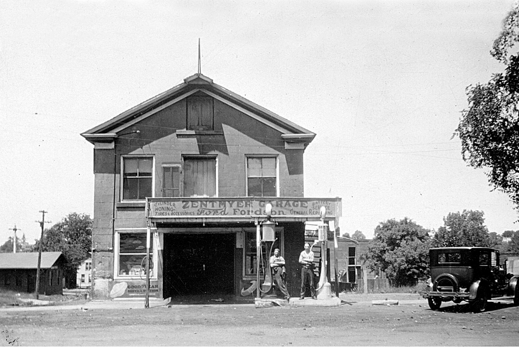
Across Jackson Street to the south, O.A. Parke’s limestone former post office and general store had subsequently become home to a variety of stores and other businesses, including a bowling alley, jewelry store, farm implement business, tin smithing business, and blacksmith shop. In 1922, a young fellow from Aurora named Earl Zentmyer bought it from its owner, Gus Shoger, and turned it into a combination gas station and Ford dealership. Zentmyer eventually bought the old Shoger Brothers Livery Stable across Main Street from the stone building and operated it as a service station and Ford dealership until it burned in 1965.

The Burkhart Block at Main and Washington was built by Oliver and Clinton Burkhart to house the Oswego State Bank in the corner storefront, the Burkhart & Shoger auto dealership to the left, and the Oswego Post Office and the switchboard for the Chicago Telephone Company in the two storefronts to the right of the bank. This photo was taken about 1913 by Dwight Young. (Little White School Museum collection)

Also included in the historic district is the brick Burkhart Block, completed at the southeast corner of Main and Washington in 1911 to mainly as the home for the Oswego State Bank in the corner storefront. But also originally housed in the structure were the Burkhart and Shoger Studebaker dealership, the new Oswego Post Office, and the local switchboard of the Chicago (later Illinois Bell) Telephone Company.

Oswego’s streets were unpaved when this photo of an early auto northbound on Main Street through the heart of the business district about 1905. During that era, the hitching posts lining the street were not decorative; they were meant to be used. More than 100 years later, the downtown streetscape still looks familiar. (Little White School Museum collection)

Over the years the very transportation routes that allowed Oswego’s downtown to grow in the first place conspired to curb that growth. In 1870, the Ottawa, Oswego & Fox River Valley Rail Road linked the coalfields lying between Ottawa and Streator with Geneva, running through Oswego and giving it a direct link with nearby Aurora. Regular passenger service meant the shopping opportunities of that much larger town were just a short train ride away, putting a brake on downtown Oswego’s expansion much beyond its three block base. Then in 1900, downtown Oswego was directly linked to downtown Aurora when the interurban trolley tracks of the Aurora, Yorkville & Morris Railway were completed. For the next 22 years, shopping in downtown Aurora was a short, cheap trolley ride away, serving to keep the selection and size of downtown businesses small.

The final blow to any major expansion of the downtown was dealt by the advent of practical, economical automobiles, trucks, and buses coupled with the post-World War I state-financed drive to build all-weather hard roads. Initial concrete highways roughly followed some of those old 1830s routes through Oswego, again making it a transportation crossroads. In all, three state highways started in Oswego and one U.S. highway passed through following those old trails. And that made it even more convenient for residents to do much of their shopping elsewhere.

Oswego’s modern downtown, recently recognized by the National Trust for Historic Preservation, has not only managed to preserve a number of historic structures, but is still home to a mix of successful small retail and service businesses. (Little White School Museum collection)

Even so, Oswego’s downtown and near-downtown maintained a mix of retail and service businesses that catered just fine to the surrounding agricultural area, from general merchandise and grocery stores to doctors and dentists to grain and livestock marketing firms.

The heart of any town is its downtown business district. Oswego’s village government and business community have been both lucky and skillful at keeping the downtown healthy, willing to spend both tax dollars and funds generated by the business community on public improvements over the years that have kept it an inviting place to visit, shop, and run a business.

And to top it all off, Oswego’s downtown is also one of the village’s—and Kendall County’s—most historic areas, anchoring the greater Oswego community since 1835.

Leave a comment

Filed under Architecture, Business, Fox River, Government, History, Illinois History, Kendall County, Local History, Native Americans, Oswego, People in History, Semi-Current Events, Transportation

The end of two significant rural traditions reflected education, agriculture change in Illinois

We just opened a new seasonal exhibit down at the Little White School Museum here in Oswego, “Back to School.”

Museum manager Annie Jordan made a deep dive into our collections and retrieved a bunch of photos, documents, and three-dimensional artifacts, from 1950s letter sweaters to the kind of slates kids used to use in lieu of expensive paper to practice arithmetic and handwriting skills. The goal, which seems successful to me, was to put more flesh on the bones of the story of how public education has evolved over the decades as told in the museum gallery’s various core exhibit.

The Little White School Museum’s “Back to School” exhibit celebrates the start of another school year with artifacts, documents, and photographs from the museum’s collections normally not on exhibit. The museum is located at 72 Polk Street, Oswego. Admission is free.

Everyone’s invited to stop by and spend some quality time browsing the new exhibit as well as the exhibits in the gallery. Regular hours are Saturday and Sunday, 9 a.m. to 2 p.m.; Monday, 4 to 9 p.m.; and Thursdays and Fridays, 2 to 6:30 p.m. Admission is free.

When I was providing some research assistance to Annie and museum assistant Emily Dutton, who was working on the exhibit’s labels, it occurred to me that, being a member of the first of the Baby Boom generation as I am, I’d seen—and participated in—one of the most significant times of change in public education in Illinois history. That era of change also coincided with eras of massive change that began in other areas during my childhood and early adulthood. That included the biggest changes in agriculture in a century (or much more) and the introduction of and miniaturization of computers that had massive effects on every aspect of life.

Public education opportunities had been divided into two categories for a century by that time. Elementary school districts educated students from first through eighth grade. Until the early years of the 20th Century, it was felt by many that eight years of schooling was enough for most people. High schools were relatively rare, as were their students. In 1916, only 175 students from all the county’s rural school districts attended at least some high school.

Until the 20th Century dawned, high school graduates were considered qualified to teach in rural schools. Then qualifications began rising and two years of college began to be required.

Oswego High School’s first graduating class, the Class of 1887, left to right, back row, Addie Kimball (Curry), Mary Smith (Young.) Sitting, Bessie Armstrong (Long), Frank Lippold, Addie Wormley (Elliott). (Little White School Museum collection)

Here in Oswego, a two-year high school course—sufficient for rural school teachers—was offered with the first graduates matriculating in 1886. Those who wanted a full, four-year degree had to travel to nearby Aurora to finish. It wasn’t until the fall of 1928 that Oswego finally offered a fully accredited, four-year high school course of study.

High schools were expensive propositions with students’ tuitions originally paid for by rural districts. Finally, the state allowed the formation of property tax-supported high school districts and in December 1936 Oswego and Yorkville area voters created the Oswego and Yorkville community high school districts. Oswego High School District Superintendent John Clayton immediately set out to increase the geographical size of the district without adding too many potential students. The strategy made sense—farmland didn’t generate many students, but it did generate tax revenue. That worked until the 68 square miles of the once overwhelmingly rural district began growing more housing developments than crops.

Church School, Wheatland Township, student body, grades 1-6, 1952. The author is in the left foreground.

I started school at the age of 6 years in the fall of 1952, joining four classmates in the first grade at Church School in Wheatland Township, Will County, here in Illinois. No kindergarten then—we dove right into Dick, Jane, Sally, and Spot; metal lunch boxes with Thermos bottles whose glass lining broke if you looked at them wrong; recess; penmanship; and the rest with none of those half-day socialization preliminaries.

Officially considered a one-room rural school, Church School was a substantial brick building that actually boasted a large classroom, boys’ and girls’ indoor bathrooms, and a tiny library room, along with a high-ceilinged basement sufficient for indoor recess on rainy days. It was given its name because it was right across the road from the Wheatland United Presbyterian “Scotch” Church.

The church and school were established by the group of Scots immigrant families that arrived on the Wheatland prairie in the 1840s and 1850s, the descendants of which were, a century later, some of my schoolmates. In the fall of 1952, our teacher, Dorothy Comerford, drove out from Joliet every school day to instruct 23 students in six grades.

We didn’t know it—Mrs. Comerford probably did, and our parents surely did—but we were participating in the last years of one-room rural schools. Seventh and eighth graders who would normally have been attending classes at Church School had already been bused into town to attend school in Oswego and sixth graders would follow the next year.

The dedication of the new flagpole at Church School in 1944 during World War II, with the entire student body attending. My sister Eileen is fourth from the left. (Little White School Museum collection)

My mother, in fact, was one of the people making sure that junior high students would have the expanded educational opportunities available in town schools. That’s because my oldest sister, Eileen, 12 years my senior, had been the only student in her grade level during her eight pre-high school years attending a couple different one-room schools. She finished her last few years at Church School, which was about a mile down the road from our farm.

Eileen told me one time that during the era when she graduated from eighth grade, graduates from all over Will County, a huge county extending all the way to the Indiana border, assembled at Lockport High School to receive their diplomas. She said she had a slight panic attack seeing that many students her own age after having no classmates her own age for her recently-completed eight years of school.

That prompted my mother’s activism. She helped establish the Oswego Mother’s Club (it eventually became the Oswego Woman’s Civic Club) that began strongly lobbying local school districts to get junior high students out of one-room schools and into town schools so they’d have access to more educational opportunities. Her efforts dovetailed nicely with the accelerating pace of public school consolidation then taking place all across Illinois.

By the early 1950s, Illinois was strongly encouraging merging rural, single-school districts into larger consolidated elementary school districts. The consolidation movement had begun years before, touted as both a tax-saving measure as well as an improvement in educational opportunities. Moving kids into larger in-town schools saved money because rural schools often had such low enrollments, sometimes as few as five or six students, which made for a great, but expensive student:teacher ratio. Larger schools could also offer a far richer curriculum for junior high students, especially in STEM (Science, Technology, Engineering, Math) areas where chemistry, biology, and physics labs were the kinds of things that would have benefited my sister, who was determined to be a nurse.

A few attempts at consolidating one-room school districts were made early on. Yorkville began considering consolidation in 1919. But efforts stalled during the Great Depression. As economic condition began to ease, consolidation efforts began again, this time out in rural areas. In June 1941, for instance, residents of the one-room Wilcox, Gaylord, and Walker schools voted to consolidate into a single district, with all students attending the Walker School at Plainfield and Simons roads southeast of Oswego.

The outbreak of World War II again stalled things, but after the war consolidation efforts, this time strongly encouraged by the State of Illinois, resumed. Teacher requirements were increased to require full four-year degrees, prompting dozens of Kendall County educators to go back to college if they wanted to keep teaching. Financial encouragement through the state aid to education formula also encouraged consolidation, not only of elementary districts with other elementary districts, but also the creation of unit districts that educated students from first grade through the senior year of high school.

Church School, Heggs at Ferguson Road, Wheatland Township, Will County, 1957. The Oswego School District’s last rural school, it closed at the end of the 1957-1958 school year. (Little White School Museum photo)

Here in the Oswego School District, it turned out that Church School, where I attended first through the first of half of third grade was one of the last three Oswego-affiliated one-room schools to operate. There had once been 11 one-room schools educating grade school students inside the bounds of the 68 square-mile area affiliated with Oswego through annexation to the high school district. Of the final three remaining schools, Willow Hill at the intersection of U.S. Route 30 and U.S. Route 34 and McCauley School on Caton Farm Road closed in the spring of 1957. Church School closed in the spring of 1958, ending the one-room country school era in the Oswego area.

(Fun fact: All three buildings are still standing, although poor Willow Hill gets more and more dilapidated every year. McCauley and Church schools have both been converted into single-family homes.)

Then in June 1961, voters in the Oswego Community Consolidated Grade School District 8 and Oswego Community Consolidated High School District 300 voted to create a new unit school district for students in first grade through high school, today’s Oswego Community Unit School District 308.

And that growth that was just getting a good start back in the late 1950s? Boy, did it keep going. One year old District 308 started the 1962-63 school year with 1,971 students. It started the current school year with just over 17,000.

So, I had the opportunity to attend a rural school very near the end of that era, and I have to say that for those first two and a half years, it provided me a very good, basic education, better than what I found when my parents moved into town. There were more students in my third grade classroom in town than had been in Church School in total, and I was in just one of three third grade classrooms, each with more than 30 students.

The thing was, the education you got in those one-room rural schools was hugely dependent on the skill of the teacher. A bad teacher could plague students through several years of school. But I, and my other Church School classmates were lucky; we had a great teacher.

Along with the end of the one-room school era, the end of diversified farming was also in sight when we moved off the farm in December 1954, soon to be replaced by specialization in grain, livestock, or dairy farming.

It was an interesting time, as two significant rural American eras came to an end.

2 Comments

Filed under Education, family, Farming, Government, History, Illinois History, Kendall County, Law, Local History, Nostalgia, Oswego, People in History, religion

Last agriculture census confirmed some trends, revealed some surprises

From the time it was settled in the late 1820s, Kendall County’s geographical location has had both its positives and its negatives.

Claiming land 40 miles west of Chicago that was located on the shoreline of Lake Michigan, the farmer-pioneers who settled the county’s rich prairie found the fast-growing city’s market for grain and livestock an economic boon. Chicago was close enough that cattle and other livestock could be driven there within a couple days. The county’s farmers were able, in fact, to create personal relationships with such prime movers of the meat industry as Phillip Armour. And in the 20 years before rail lines pushed west, the city was also within realistic grain hauling distance.

Kendall County not only borders on three of the Chicago metro region’s populous “Collar Counties,” but it is within convenient distance of the city itself.

But the county’s location also posed some negatives, especially for those more interested in business than farming. Oswego, in the northeast corner of the county, was never able to grow its small two-block business district because of its proximity to Aurora, just six miles away. Aurora, with its large downtown business district fueled by heavy industry and the shops of the Chicago, Burlington & Quincy Railroad, drew enough business north to keep the village’s retail district from growing. Those effects only worsened when the Ottawa, Oswego, and Fox River Valley Rail Road opened in 1870 linking the coal fields south of Ottawa with Fox Valley towns as far north as Geneva. The advent of the interurban trolley, and completion of the line running from downtown Aurora through downtown Oswego to downtown Yorkville made the situation worse.

The effects of the county’s location was to keep it almost entirely rural with the business of its scattered hamlets, villages, and towns aimed at supporting the farms that surrounded them. That 125-year era ended in the 1950s when Caterpillar Tractor Company built a sprawling plant in Oswego Township that eventually employed some 7,000 people and the manufacturing arm of AT&T expanded an old wallpaper factory, also in Oswego Township, to make electronic communications equipment. Those factories made an already-existing post World War II housing shortage in the area worse, prompting the area’s first sustained population growth since the Civil War. It didn’t take people elsewhere in the Chicago metro region long to decide Kendall County’s bucolic landscape was an inviting place to raise families. That first growth spurt of the late 1950s and 1960s, was joined by further growth eras culminating in the early 2000s when Kendall County, in percentage terms, was the fastest growing county in the United States.

Kendall’s farmers found, given the distance, it was practical to drive their cattle, hogs, sheep, and horses to the Chicago market, a definite plus in the pre-railroad era. After railroads and then interurban trolley lines and eventually all-season paved roads connected the county to Chicago it opened markets for everything from dairy products to honey and fruit.

For the 40 years from the 1970s through the first decade of the 2000s, the county grew housing and retail developments at a dizzying rate, as once productive farmland changed from growing crops to growing homes and businesses. The area’s explosive growth took a breather with the Great Recession of 2008 when the world’s economic system was nearly wrecked by the greed and illegal activities of the financial services industry.

The effect of all of that, along with profound changes in agriculture itself, had a not inconsiderable impact on farming in Kendall County, something I’ve been watching for decades now.

Threshing small grains—oats, wheat, rye, barley—was both labor and capital intensive, requiring farmers to create cooperatives to buy and use the complicated harvesting equipment of the era. Members of the Harvey Threshing Ring farmed on and around the Harvey Road east of Oswego. (Little White School Museum collection)

As a statistical measure of those changes, every five years, the U.S. Department of Agriculture conducts a farm census, with the last one completed in 2017. And with five years having passed since then, farmers and ranchers all over the U.S. got packets of surveys in June asking for information about their operations for the latest farm census.

That last ag census, taken back in 2017, reported a host of facts about Kendall County and that continuing change from an almost entirely rural area to a community that seems to be growing more and more homes and shopping centers than row crops every year.

A modern combine (short for “combined harvester”) does the work of several men and machines. Improved grain hybrids and high-tech equipment have combined for explosive growth in grain yields and much larger, although far fewer, farms—and farmers.

Some of the census information confirmed overall trends that have been continuing over the past several decades, while others suggested the farm scene itself is changing. Not all that change has been negative, either. For instance, the census reported that, as of 2017 at least, Kendall County farms were overwhelmingly still in the hands of families and not corporations. A total of 92 percent of the county’s ag land was in the hands of family farms, the census reported.

On the other hand, there were interesting changes to report along with some more predictable information. Two county farms, for instance, reported raising emus, not exactly the usual kind of poultry you’d perhaps expect to find out here on the northern Illinois prairie.

Emu wrangling? In Kendall County? In the 2017 Census of Agriculture, two county farms reported raising the big birds.

Other statistics in the report contained trends both continuing and interrupted. The number of Kendall County farms continued to decline, reaching a new all-time low of just 313. That’s nearly 100 fewer farms than the 412 the census reported in 2002 and 773 fewer farms than existed here in 1950.

But while the number of farms declined, the size of the remaining farms continued to increase as consolidation in the agriculture sector—even among family farms—continued. In 2017, the average Kendall County farm covered 419 acres. In 2012, Kendall County farms averaged 356 acres, and back in 1950 when modern farming was on the cusp of major changes in farm use philosophy, the average farm here was just 180 acres.

The trend of more and more ag land turning into housing and business developments, however, took a breather in 2017. The census numbers suggested the housing market crash of 2008 had an impact on the previously steady repurposing of farmland. For the first time since 1987—the result of another economic downturn—land was apparently returned to agriculture production instead of being used for development. According to census statistics, a little over 8,000 acres were put back into crop production between 2012 and 2017.

Even with that pause, the value of Kendall’s farmland continued to rise, going up 4.3 percent from 2012, reaching a record average of $9,059 an acre, the 2017 census reported.

As this 1939 aerial photo shows, at that time, a few years before the start of World War II, Oswego was a small village set among a surrounding agricultural area. Oswego’s population in 1940 was 978. (Little White School Museum collection)

Likewise, the value of farm homes and buildings continued to increase along with the land on which they sit. In 2017, the value of the average Kendall County farm’s land and buildings stood at nearly $4 million, a 29 percent increase over those same values in 2012.

The census counts farm producers these days—at one time called farm operators—and they found 548 of them in Kendall County. The department’s official definition of a producer is: “Persons or entities, including farmers, ranchers, loggers, agricultural harvesters and fishermen, that engage in the production or harvesting of an agricultural product.” Given that definition, it’s clear one farm can have more than one “operator,” and thus the change in nomenclature to producer.

Now with a population of more than 35,000 (more than three times the population of all of Kendall County in 1939), Oswego is no longer small, and instead of farmland is now set among the housing and commercial developments that surround it. On-going development in Kendall County is the main driver behind the substantial increases in the price of land since World War II. (Google Earth image)

The 2017 census reported 380 male farm producers, down almost 4 percent from 2012, while the number of female producers in 2017 was 168, up a hefty 15 percent over 2012.

Another trend that continued was the increasing number of Kendall County farm producers who work off the farm at least part of the time. Nearly 53 percent of the county’s farm producers reported working off the farm at least part of the time in 2017. That was the highest number in a quarter century.

While the county has lost a significant amount of farmland to development over the past several decades, there has been no corresponding decline in production. Modern hybrids and continually improving farming technology seem to be combining to offset the loss of Kendall County farmland to housing and commercial development. In 2002, 82 percent of the county was being farmed. By 2017, that number had decreased fairly sharply to 67 percent. But even with less land available to farm, crop yields had increased sharply. For instance, in 2002, county farmers produced 9,249,000 bushels of corn and 2,761,000 bushels of soybeans. But in 2017, with less land under cultivation, the county’s farmers produced a remarkable 13,780,000 bushels of corn, a 49 percent increase, and 3,122,000 bushels of soybeans, up 13 percent.

Kendall was also contributing to another interesting statewide agricultural trend: The increasing number of honeybee colonies on farms. In the 2012 ag census, 919 Illinois farms reported having honeybee colonies. The number nearly doubled in 2017, with 1,770 farms reporting colonies. In Kendall County, 14 farms reported having 296 honeybee colonies in 2017, with a bit over 10,000 pounds of honey collected during the previous year. The 2017 result was not an outlier, either. Between 2007 and 2012, the number of farms producing honey doubled statewide and here in Kendall County, the number of honeybee colonies increased by 65 percent.

The Oswego Depot, its sidings, livestock loading chute, and the trackside stockyards—along with the livestock producers that once made use of them—are all gone today, but once provided a substantial economic boost for the area. (Little White School Museum collection)

While grain production was booming in 2017, the county’s livestock production continued it’s long-term decline. In 1950, during the heyday of diversified farming where each farm raised livestock as well as a variety of crops, 861 Kendall County farms reported having some beef cattle, 694 farms reported having at least one milk cow, and 741 farms reported raising hogs. The switch to specialized livestock or grain farming accelerated in the 1960s. And by the time the 2017 farm census was taken, with the switch to specialized grain or livestock farming, only 39 county farms reported having any beef cattle, only 1 reported owning milk cows, and 11 reported having hogs.

The switch away from raising livestock was also clearly evident in the sharp reduction in Kendall County acreage devoted to corn raised for silage to feed livestock as well as acreage devoted to pastureland. In 1950, county farmers raised 2,236 acres of corn for silage and had almost 24,000 acres devoted to pastureland. By 2017, county farmers only grew corn for silage on about 300 acres and only devoted about 1,600 acres to pastureland.

In 2017, Kendall County was still recovering from that near-total collapse of the world financial system driven by illegal and unethical practices of giant financial corporations. Recovery was slow, but by the time the 2020 U.S. Census was taken, population growth was already recovering in Kendall County, to the point that it was the fastest growing county in Illinois.

That’s why it will be so interesting to see what new information about the county farm scene this summer’s agricultural census will uncover.

Leave a comment

Filed under Business, Farming, Food, Government, History, Illinois History, Kendall County, Local History, Oswego, Semi-Current Events, Technology, Transportation