
This year marks the anniversaries of a couple of important road projects—roads that still remain major arterial routes here in Oswego and Kendall County.
The paving of modern U.S. Route 34–then designated Route 18–from Aurora via Oswego, Yorkville, and Plano and on to Princeton in western Illinois was finished 100 years ago this year. In addition, paving work on Ill. Route 25 from Aurora to the Route 34 intersection in downtown Oswego was also finally completed in 1924 after being started as a hard road demonstration project back in 1914.
While the two highways are separate routes these days, time was that Route 25 nearly became Route 34.
Today, the Route 34 Corridor is recognized as not only an engine of economic and population growth, but also one of population sprawl. For a while back in the early 2000s, Route 34 almost looked like a housing development gun aimed right at little Kendall County by densely populated counties to the east—between 1990 and 2010, Oswego Township’s population nearly tripled.

The conception of those two road projects, if not the realization of the profound effect they would eventually have on the Village of Oswego, began in the years before World War I as more and more Illinois residents, both rural and urban, began lobbying for better roads. With few exceptions, the state’s roads outside large cities—and often inside them, too—were dirt-surfaced and turned into literal mudholes after every rain or season change. As historian David Wrone put it, “With rare exceptions, the roads of Illinois in 1910 differed only in the number of miles from the roads of 1818.”
Then various groups began militating for better roads, the first of which were the “wheelmen,” bicycle enthusiasts who rode the high-wheeled cycles of the 1890s. Then, with the introduction of automobiles and trucks, motorists joined the better roads call. And finally farmers did, too, grudgingly acknowledging that better roads would make it easier for them to get their livestock and crops to market and to bring back home the groceries, clothing, and other things they needed.
As the Illinois Highway Improvement Association put it following their first conference in 1912: “Improved roads mean better schools and larger attendance; better health and quicker medical attention; better farms and more cultivated land; better crops and cheaper transportation; better economic conditions and more producers; better social conditions and less isolation; better church attendance and better citizens; better postal service and closer friends; better business and more consumers; better industries and more employment; a better state and a better nation.”

During the next several years, work on persuading Illinois residents that a system of paved roads would benefit everyone continued. Eventually, the matter was put before the voters in a November 1918 statewide referendum. The state’s local governments, along with a variety of private “good roads” organizations, including the Illinois Farm Bureau, heavily—and successfully—lobbied voters to pass the bond issue, campaigning to “Pull Illinois out of the Mud.”
Even though the U.S. was deeply engaged in World War I, Illinois voters overwhelmingly approved a $60 million bond issue on Nov. 5, 1918 to build a network of concrete-surfaced highways that would be impervious to the state’s notoriously changeable weather and link every county in the state.
Ever more efficient, affordable, and dependable motor vehicles, from cars to trucks to buses, were available in 1918. But, as noted above, the state’s deplorable road system virtually disappeared in a sea of mud every spring and after heavy rains. The problem often prevented farm families from visiting town to sell grain and livestock and to do their shopping for weeks at a time.

The original route northern Kendall County’s hard road was to take was south from Aurora on what is today Ill. Route 25 on a section of concrete road already built as a demonstration from that city to the Waubonsie Creek bridge in Oswego. Then the route was to head south on what’s today Ill. Route 71 to Van Emmon Road. The mile of Van Emmon from modern Route 71 into downtown Yorkville had been paved in 1917 by Kendall County as another hard road demonstration project. The route was then to cross the river at Yorkville and go on west to Plano, Sandwich, and, eventually, Princeton.
But with the election of Len Small as Illinois’ new governor in 1921, business interests successfully lobbied for a straighter route from Aurora west. While Kendall County residents were looking for maximum hard road access, business interests—primarily trucking companies—were looking for efficiency, meaning a straighter, shorter route.
The new route ignored both existing stretches of paved road. Instead, the chosen right-of-way ran down modern Ill. Route 31 from Aurora to Oswego, where it continued directly west on modern Route 34 to Plano. It thereby bypassed both Oswego’s and Yorkville’s downtowns. To tamp down Kendall County’s anger–which was considerable–the state agreed to build stub highways from the new highway into both downtowns.

What with survey and design work and right-of-way purchases, it took a few years for actual construction to begin, but by April 1924, contractors were ready to start building from Aurora west on what was then called Route 18—today’s Routes 31 and 34—and nicknamed the Cannon Ball Trail (not to be confused with the local Cannonball Trail in modern Kane and Kendall counties).
The Kendall County Record reported on April 16, 1924: “The completing of the Cannon Ball Trail between Oswego and Yorkville on the west side of the river has been started.”
Since so many miles of concrete highway were being built around the region, the Record’s editor had a safety suggestion for highway officials to consider, one we pretty much take for granted these days. On April 23, he wrote “Auto drivers who are much on the roads would appreciate the placing of the black center line on cement roads. This mark comes the closest in being an accident preventative than any other one of the many suggested corrections. These black center marks might well be built into the roads when they are installed, or at the latest, placed when opened for traffic and replaced as soon as they become obliterated.”

Crews completed sections of the route during the next several months, including a new overpass across the Chicago, Burlington & Quincy Railroad tracks at what was called the Wormley Crossing north of Oswego on modern Ill. Route 31. Thirty years later, Caterpillar, Inc. would locate their new, sprawling manufacturing plant near that crossing.
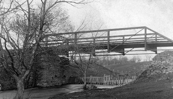
In addition to the Route 18 project, the state decided that since the concrete road on the east side of the river was to be extended across Waubonsie Creek into Oswego to connect with the stub running across the river from Route 18, a new bridge across the creek would be required to handle the expected increased traffic load. The old iron truss bridge across the creek had been built some decades previously. The replacement was to be a state-of-the-art concrete bridge.
On May 28, the Record’s Oswego correspondent reported: “The last section of the Cannon Ball concrete road was completed Friday. In twenty-one days it will be opened for traffic. Grading will begin at once on a road from the [Red Brick] school house to the end of the concrete road on the east side of the river. When this road is finished Oswego will be sitting on top of the world in so far as good roads can make it.” The Red Brick School was located where the Byline Bank and the Oswego Post Office are situated today.
The last section of old Route 18 west of Somonauk to Princeton wasn’t paved until the fall of 1929, but by then Kendall County residents had been enjoying use of the road east of there for five years.
Meanwhile in Oswego, the hard road link with Aurora—Route 25, then called the East River Road—was completed in December 1924. As the Record’s Oswego correspondent happily noted on Dec. 10: “The concrete road on the east side of the river will be open for traffic Wednesday, Dec. 10. This is a great improvement for Oswego. The bridge across the Waubonsie creek is a beautiful piece of concrete work. Oswego is proud of this improvement and gives praise to the county and village who worked so faithfully for this beautiful bridge and highway.”
All that road construction led to a number of Kendall County transportation changes. The main one was the final closure of the interurban trolley line from Aurora through Oswego to Yorkville. The Illinois Commerce Commission allowed the line to close as long as it was replaced with bus service making use of some of those new concrete highways.

As the Record reported on Aug. 6, 1924: “Through an order from the Illinois Commerce Commission, the interurban line from the [Fox River amusement] park south of Montgomery to Yorkville will be discontinued as soon as buses are provided to take care of the traffic. This permission comes after a long battle with the commission and a period of wretched service by the street car company at this end of the line… The bus service will be started as soon as the vehicles can be procured.”
In addition, the interurban line from Yorkville to Morris also stopped service in 1924, only to be bought by a farmers’ cooperative that kept it open until 1938 when it, too, succumbed to motor vehicle competition from the newly paved Ill. Route 47.

Completion of modern Route 34 between Oswego and Naperville—then designated Route 65—had to wait almost an entire decade. Work began in February 1933 on the project, buoyed by some of Franklin Roosevelt’s New Deal federal funds. The initial paving project, with the exception of the stretch crossing the Lincoln Highway (U.S. Route 30) and the Elgin, Joliet & Eastern Railway tracks a few miles east of Oswego, was finished by October 1933. The EJ&E overpass and the Route 30-Route 65 interchange weren’t finished until late in 1936, finally completing the paved highway between Naperville and Oswego.
The next year, 1937, the state changed highway routes and numbers. The old Route 34 running north from the west end of the Oswego bridge across the Fox River was renamed Ill. Route 31—its modern designation. Route 65 between Naperville and Oswego was renamed U.S. Route 34, which now bypassed Aurora all together. And with that, today’s system of highways all got their modern designations. Also, Oswego became either the origin or terminus of three state highways, Ill. Routes 31, 25, and a couple years later, 71.

So that’s how the whole Route 34 thing got its start, going from a country road linking Oswego to the east with Naperville and west to Plano and Sandwich. The road was paved in the 1920s and 1930s, allowing Oswego Township residents easier access to the burgeoning jobs market in Chicago’s near-west suburbs to the east and also offered an economically important route for livestock and grain shipments coming from the west. In the early 2000s, to handle the ever-increasing traffic load, Route 34 was four-laned between Oswego and Naperville, while stretches farther west were also four-laned between Orchard Road and Sandwich.

Today, that former stretch of two-lane country highway between Oswego and Naperville is a divided four-lane economic engine dotted with shopping centers, business parks, and housing developments.
And even though it’s a century on now, transportation improvements and modifications still seem to be the order of the day around these parts as another construction season is again upon us.

GREAT piece as usual!! I learned a bunch and think I might just take a drive on 34 soon it’s been a while.