Tag Archives: Fox River

Local historians’ popular ‘What if?’ game

A favorite mind game played by a lot of historians is wondering how things might have been, if only…

For instance, what would have happened had Lee won at Gettysburg? How would North America have fared had George Washington been killed during Braddock’s Defeat in the French and Indian War? What if the Nazis had been first to invent the atom bomb? How would Abraham Lincoln’s life been changed had his mother not died of the “milk sick” when he was a child?

Those kinds of historical speculations are in the cosmic realm—things that might or might not have changed our whole world. But there are thousands of historical micro-events at the local level that have had huge impacts on the ways in which the Fox River Valley grew and developed. Many of those incidents seem minor, but had they turned out differently, our communities would have been profoundly changed.

In the first half of the 19th Century, Montgomery was on the move as the U.S. Government’s official 1842 survey map of Aurora Township illustrates. The road from Naper’s Settlement is shown as a dotted line heading west by southwest, crossing the Fox River on “Gray’s Bridge” marked with the red arrow. (Illinois State Archives Federal Township Plats of Illinois collection)

In the first half of the 19th Century, Montgomery was on the move as the U.S. Government’s official 1842 survey map of Aurora Township illustrates. The road from Naper’s Settlement is shown as a dotted line heading west by southwest, crossing the Fox River on “Gray’s Bridge” marked with the red arrow. (Illinois State Archives Federal Township Plats of Illinois collection)

For instance, what if Daniel Gray, the energetic founder of Montgomery, had not succumbed to illness and died during the winter of 1854? Gray was the founder and the soul of Montgomery. He was reportedly an indomitable force for development and business activities. Upon his death, Montgomery failed to live up to the potential Gray had mapped for it. Had Gray lived, the town could well have grown to rival its neighbor to the north, Aurora, in terms of its industrial base. Gray had, at the time of his death, a number of manufacturing operations going on, including a foundry and a large factory manufacturing farm equipment. At the time of his death he was working on a steam engine factory, something that would have added greatly to the village’s industrial base, not to mention that of the entire Fox Valley.

An even bigger question is what might have happened had the CB&Q Railroad crossed the river at Oswego instead of Aurora when it was extending its tracks west of Chicago in the 1850s?

That the railroad favored the crossing at Oswego was mentioned in several early histories and in at least one newspaper account from the 1850s. Whether the railroad was serious about the whole thing was somewhat questionable—after the fact stories like that are a dime a historical dozen. At least they were until I ran across a map in the Library of Congress’s collections. The map, published in 1854— “Rail road and county map of Illinois showing its internal improvements”—was designed to show the existing and proposed public improvements, including roads, canals, and railroads, in the state. The map illustrates a number of rail lines radiating west from Chicago, including the main line from Chicago to Galena, which included the Aurora Branch line.

Today, that line crosses the river at Aurora before trending generally west southwest through Kendall County on its way to the Mississippi River.

The blue line on the Rail Road and County Map of Illinois Showing Its Internal Improvements, 1854 by Ensign, Bridgeman & Fanning, New York marks the proposed route of the Chicago, Burlington & Quincy Railroad as it was supposed to cross the Fox River at Oswego. After Oswego turned the railroad’s backers down, the line crossed at Aurora instead. (Library of Congress American Memories Collection)

The blue line on the Rail Road and County Map of Illinois Showing Its Internal Improvements, 1854 by Ensign, Bridgeman & Fanning, New York marks the proposed route of the Chicago, Burlington & Quincy Railroad as it was supposed to cross the Fox River at Oswego. After Oswego turned the railroad’s backers down, the line crossed at Aurora instead. (Library of Congress American Memories Collection)

But that’s not what the plans were in 1853 when the information for the map was gathered. Instead, the railroad wanted to cross at Oswego, and that’s exactly what the map shows. The map shows Aurora Branch line extending west from Turner’s Junction, now West Chicago, southwesterly to Batavia before heading south to Aurora. From Aurora, the line continues south along the Fox River to Oswego, where it is shown crossing the river where it is at its narrowest point, before heading southwesterly once again.

According to a newspaper account from an 1857 edition of the Kendall County Courier published in Oswego, the village fathers were enamored with plank roads, not railroads. In fact, the Chicago, Naperville and Oswego Plank Road company was busy extending a plank road west from Chicago on what would one day become Ogden Avenue—U.S. Route 34. Oswego was to be the terminus of the new road, something that would have greatly enhanced its economic standing. In addition, the Oswego and Indiana Plank Road Company was busy selling shares in their road, which was to connect Oswego with an undesignated place in Indiana. So with the chance to become a plank road hub, Oswego apparently told the railroad company to take a flying leap, which they did, deciding to cross the Fox River at Aurora instead of Oswego. And as a result of that decision, Aurora got the CB&Q shops, the roundhouse, and all the other accouterments of railroading that turned it into one of Illinois’ largest cities.

A sketch of the Oswego & Indiana Plank Road toll gate that was located about a mile and a half southeast of Plainfield on what is today U.S. Route 30 at Lily Cache Creek in Plainfield. Despite its grand name, the plank road reached neither Oswego nor Indiana. (Illinois Digital Archives and Plainfield Historical Society collections)

A sketch of the Oswego & Indiana Plank Road toll gate that was located about a mile and a half southeast of Plainfield on what is today U.S. Route 30 at Lily Cache Creek in Plainfield. Despite its grand name, the plank road reached neither Oswego nor Indiana. (Illinois Digital Archives and Plainfield Historical Society collections)

Oswego, meanwhile, lost out all the way around. The Chicago, Naperville & Oswego Plank Road Company went broke after extending the route to Naperville; the section to Oswego was never built. In addition, the only stretch of the Oswego & Indiana Plank Road built connected Joliet with Plainfield on the modern route of U.S. Route 30, plus an extremely short stretch west from Plainfield. It never reached Oswego, either.

It turned out that plank roads were expensive to maintain, and the tolls never covered the construction expenses, much less necessary maintenance. And they were being built just as timber was becoming scarce in northern Illinois thanks to the building boom the area was experiencing.

But the railroad did prove successful. Crossing as it did at Aurora, the line passed two miles west of Oswego, and about that far from Bristol—then the north side of Yorkville. Both towns established stations on the main line, but not until 1870 did the two towns get their own rail line, and then it was a branch line and not a main line.

What would have happened to Kendall County had Oswego accepted the rail crossing in 1853? The county seat might well have stayed in Oswego instead of being moved to Yorkville in 1864, and economic growth would likely have been significant for the whole county.

It’s an entertaining game, historical speculation is. What would have happened had the government followed through with their 1867 survey of the Fox River and made the river navigable from Ottawa to Oswego? What if a con man hadn’t sapped the economic strength of the Illinois and Midland Railroad from Newark to Millington? It’s a great game; anyone can play, and it’s free!

Leave a comment

Filed under Fox River, Illinois History, Kendall County, Local History, Oswego, Transportation

Confessions of a “free range kid”…

A couple months ago, the 24 hour news cycle glommed onto a story about “free range kids.” Turns out, there are parents who don’t believe their kids need to be scheduled 24-7, and that, in fact, they think kids can benefit by learning a measure of self-reliance.

This is not an easy road for parents to take in this day and age of abject fear of just about everything, including the seeming rash of child abductions. Which turn out to be another artifact of modern fear and refusal to credit facts. Because actual facts would prove that random child abductions are extremely rare—and always have been—those faces on the milk cartons included. Most child abductions are by parents or other relatives, not random child molesters prowling the streets. Actually, according to government statistics, little kids are far more likely to be killed by a family member or an acquaintance.

In addition, violent crime of all kinds has been sharply decreasing for a couple decades now, although people’s worry about crime have been increasing. Violent crime of all kinds in the U.S. decreased by 48 percent between 1995 and 2013. But during the same era, our fear of crime skyrocketed, something we have to credit that 24-hour news cycle noted above, plus right wing hate radio and FOX News, both groups which have a vested interest in stoking unreasoning fear. They could be citing the, you know, actual facts, but that wouldn’t play well with their audience or their sponsors and donors. As Upton Sinclair put it: “It is difficult to get a man to understand something, when his salary depends upon his not understanding it!”

The author as a young biker with his cycle decorated for the annual Memorial Day Parade, but nonetheless ready to rumble.

The author as a young biker with his cycle decorated for the annual Memorial Day Parade, but nonetheless ready to rumble, and probably for a game of ditch ’em after supper.

The fact is that crime probably isn’t a whole lot more prevalent when our increased population is taken into account than it was when I was a kid. And back then, in the 1950s, the current fixation on scheduling kids 24/7 wasn’t even possible, at least not in our small Illinois town. Turns out, I was a free range kid.

There simply wasn’t much to do, so we made our own entertainment. Both my folks worked, my dad selling and delivering livestock feed and my mother working at a series of bookkeeping jobs. As a result, my summers from third grade on were the sort of carefree times you read about in The Adventures of Tom Sawyer. We were corrupted by reading books by the aforementioned Twain, as well as the Penrod books by Booth Tarkington and—one of our particular, all-time favorites—Thomas Bailey Aldrich’s The Story of a Bad Boy. Yes, Tarkington’s books on reading 50 years on are remarkably racist and Aldrich was a nativist of the worst stripe. But in those innocent days, the books were mostly useful for introducing the kinds of devilment our ancestors developed, and which we aimed to perfect.

We spent hours every day on the river in our flatbottomed scows, poling up and down the stream because it was far to shallow for oars. Sometimes we fished, although in those years, the fish were pitiful things, since the river was so polluted. It was so polluted, in fact, that we knew enough to never wade barefoot for fear of getting a cut or scrape. Chemical companies upstream figured the river was their own private disposal. One of them dumped cyanide in the river one fine day, killing all the fish—and almost every other aquatic creature, for that matter—for a 10 mile stretch of stream. We counted more than 500 dead fish along my folks’ 132 feet of shoreline. Along with the stunted bullheads and bluegills that we usually caught and the giant carp that infested the river were big bass, large catfish, and even a northern pike or two, fish we had no idea could even survive in our dirty stream (thanks for the allusion, Pete).

If worse came to worst, we'd head over to the park district playground at the Red Brick School to play croquet golf or volleyball or shoot arrows in the neighborhood of the targets. But it was generally considered far too structured for us free spirits.

If worse came to worst, we’d head over to the park district playground at the Red Brick School to play croquet golf or volleyball or shoot arrows in the neighborhood of the targets. But it was generally considered far too structured for us free spirits.

Even so, we were fascinated with exploring the river’s islands, looking for this and that, or just drifting along on a sunny afternoon. I bought my scow from a young fellow up river, but most of us built our own. Most were lightly built, but not mine, which was built of 1″ lumber throughout and was so heavy—and stable—that I could jump up and down on one of the gunwales and it would barely rock.

When we got tired of playing on the river, we’d repair to the woods across the street from my house where we cleared bicycle trails connecting “towns” we’d built with windfallen sticks we harvested from under the trees. Our houses sported gabled, thatched roofs thanks to the tall grasses that grew on some of the islands that were fairly rainproof.

Many an evening was spent sitting on the concrete steps on the corner of Main and Washington Street watching for the rarest out-of-state license plates we could see. Or trying to persuade truckers to lay on their air horns by vigorously pumping our bent arms up and down as they passed. Sometimes they even honked, too.

Many an evening was spent sitting on the concrete steps on the corner of Main and Washington Street watching for the rarest out-of-state license plates we could see. Or trying to persuade truckers to lay on their air horns by vigorously pumping our bent arms up and down as they passed. Sometimes they even honked, too.

In the evening, after supper, we’d head up to town to sit on the corner of Main Street and Route 34 and look for out-of-state license plates in those years when Ike’s Interstate system was under construction and U.S. highways were major transportation corridors, or play games of ditch-em on our bikes that taught us every nook, cranny, and back alley of our little village.

There were the pick-up games of baseball, First Bounce or Fly, and 500, and sometimes we’d even attend the park district’s youth programming—but that was very much a last resort. We didn’t much care for organized “fun,” and most of us still don’t. I suppose it was good training for the 1960s, attitudes that even the military service so many of us contributed didn’t, as far as I can tell, have much of an impact.

It was pretty much as idyllic a childhood as anyone could imagine. Boring? Sometimes, you bet it was, but it turns out boredom is a creative force, one that too many modern kids are not given the opportunity to enjoy along with the unstructured, creative play we enjoyed growing up in plenty.


2 Comments

Filed under Fox River, Kendall County, Local History, Nostalgia, Oswego, Science stuff, Semi-Current Events

Crowdsourcing the fate of the St. Charles Experiment…

From what I read on the Internet these days, crowdsourcing is all the rage among the cool kids. Apparently, you can visit a crowdsourcing web site and solicit funds to make that movie on the history of darning needles you’ve been hankering after for years, or persuade people to fund that new invention you’ve come up with to do the Popeil Pocket Fisherman one better.

Thinking about that in the shower this morning, I had an idea to try to do some crowdsourcing historical research.

So here’s the deal: Back in the 1840s, a fellow that some might have called a crackpot, but others may have called a visionary, decided to build a steam boat here in northern Illinois on the Fox River, and then sail it down to Ottawa where the Fox empties into the Illinois, down the Illinois to Grafton where it empties into the Mississippi, down the Mississippi to the Ohio, then up the Ohio and eventually all the way to the St. Lawrence River in Canada. No small plans did this gentleman make. I related the story here once before, but I never get tired of telling people about it, so I’ll let the Oct. 2, 1840 edition of the Illinois Free Trader at Ottawa lay out the entire story:

 Fox River Navigation — Arrival

of the Bark “St. Charles Experiment.”

On Tuesday evening last Mr. Joseph P. Keiser and lady arrived at our steamboat landing in a beautiful bark, six tons burthen, from St. Charles, Kane county, Illinois. Mr. K. left St. Charles on the 18th inst. amid the smiling countenances of a large collection of citizens of that place who had assembled to witness his departure on this hazardous and novel enterprise. He descended Fox River without much trouble, notwithstanding the low stage of the water at present and the dam at Green’s mill, &c, might be considered by some as presenting insurmountable barriers.

The St. Charles Experiment would have steamed past Starved Rock on its voyage own the Illinois River to the Mississippi in October 1840.

The St. Charles Experiment would have steamed past Starved Rock on its voyage own the Illinois River to the Mississippi in October 1840.

The “Experiment,” we believe, is the first craft that has ever descended this beautiful stream this distance, save, perhaps, the frail bark of the Indian in days gone by. The distance from St. Charles to this place is about eighty miles by water, passing through a section of country which, in point of fertility, is not surpassed by any tract of country in the Union, and to the enterprise and exertions of Mr. Keiser belongs the honor of first undertaking and accomplishing the navigation of Fox River, which winds its meandering course through it.

The object of Mr. K’s enterprise is somewhat of a novelty. His design is to travel by water to the river St. Lawrence, in Lower Canada, by the following route: From St. Charles down Fox River to its mouth at Ottawa; thence down the Illinois to its mouth; thence down the Mississippi to the mouth of the Ohio; thence up the Ohio river to Beaver, Pa.; thence by way of the Ohio and Pennsylvania Canal to Akron, O.; thence on the Ohio Canal to Cleveland; thence on lake Erie to Buffalo, N.Y.; thence on the Welland Canal to Lake Ontario; and thence to the river St. Lawrence.

This route will doubtless prove arduous to our friend, but he is in fine spirits and considers his worst difficulties ended by having successfully descended Fox River at the present stage of the water. He has our best wishes for a safe and pleasant journey, hoping that he may be able to inform us of his safe arrival at his distant destination.

So far as I’ve been able to tell, the St. Charles Experiment is the only steamboat to have ever navigated the Fox from the river’s northern reaches to its mouth at Ottawa.

And here’s my historical crowdsourcing question: What the heck ever happened to Mr. K, his lady wife, and the St. Charles Experiment? Did they make it to the Mississippi? Did they actually steam up the Ohio to the canal system, puff through Akron, and into Lake Erie?

Perhaps some hardy researchers with access to microfilm newspaper files in towns along the route of the St. Charles Experiment will check for the period starting in early October 1840 and see if a strange craft from a town on the Illinois prairies stopped by to say hello on its journey to Canada.

I’ve wondered about the fate of the Keisers for many years now, and would like to put a “-30-“ at the end of their story. Can any of you loyal readers of historyonthefox add to the tale?

Leave a comment

Filed under Fox River, Illinois History, Local History, People in History, Technology, Transportation

Main Street isn’t always a main street…

As I suggested in my last post, Oswego’s downtown business district is located on Main Street, a pretty American sort of thing for a town. But there are a surprising number of towns, large and small, where the main business district is not located on Main Street—supposing they have a Main Street at all.

Main Street–now East Galena Boulevard–in downtown Aurora about 1940.

Main Street–now East Galena Boulevard–in downtown Aurora about 1940.

Take Aurora for instance, Illinois’ second city with a population of about 200,000. Downtown Aurora’s main business district—although a shadow of its former self—stretches along Broadway, not Main Street. In fact, Aurora has no Main Street any more. It used to have a Main Street many years ago, a commercial street that crossed Broadway at one of the city’s busiest intersections, but the name was changed to East Galena Boulevard a long time ago. Not so long that my mother, who was born and raised mostly in the East Side’s “Dutchtown” German ethnic neighborhood, didn’t often forget and call it Main Street fairly often before her death in the late 1980s. Today, about the only reminder the city used to have a Main Street is the old Main Street Baptist Church, located on East Galena.

Just to our north is Montgomery, tucked between Aurora and Oswego along the banks of the Fox River. Montgomery indeed has a Main Street, but it’s not really a main street, if you get my drift. Instead, Montgomery’s real main street is actually two streets, River and Webster. Montgomery, even more than Oswego, suffered from its close proximity to Aurora, which discouraged the development of a true retail business district. Instead, stores were sort of strung out along River and Webster streets—and not many of them at that. Main Street, meanwhile, runs perpendicular to Webster Street. On its south end, it’s a mostly residential street. North of Webster, Main Street is dominated by the Lyon Metal Products, Inc. factory and some other quasi-industrial properties before it reverts back to a residential area.

Plano's Main Street, laid out from the beginning with stores facing the railroad tracks, is still its main downtown retail street.

Plano’s Main Street, laid out from the beginning with stores facing the railroad tracks, is still its main downtown retail street.

Among Kendall County’s other municipalities, Plano can be considered one with a real main Main Street, and that’s despite the city growing up as a railroad town. Classic railroad towns have their business district stores facing the tracks. Often, there are streets on either side of the tracks, each with blocks of stores facing the tracks—as long as they were designed from the ground up as railroad towns, as Plano definitely was. Lewis Steward had promised the promoters of the Chicago, Burlington, and Quincy Railroad that if they extended their tracks through the extensive land he owned that he’d create a city. Which he did. Plano’s Main Street is laid out north of and parallel to the CB&Q’s main line, with blocks of storefronts laid out on the north side of the street facing the tracks so rail travelers could clearly see them.

With its stores facing the railroad tracks, Plano’s design theory was much like Oswego’s, although when Oswego was laid out by Lewis B. Judson and Levi F. Arnold in 1835, the major mode of transportation was the stagecoach. Therefore the stores were laid out facing Main Street, which was part of the western branch of the well-traveled Chicago to Ottawa Trail, running west southwest from Chicago through Naperville to Oswego and then southwest to Ottawa.

Newark, in far southwest Kendall County, was located on the same mail stage route as Oswego. As a result, Newark’s Main Street, laid out along the Chicago to Ottawa Trail, was also the heart of the village’s retail district. Like Oswego’s, Newark’s stores faced Main Street in an effort to appeal to stage travelers.

Sandwich's main business district street is Railroad Street, with its stores and hotel facing the tracks. Meanwhile, Main Street in Sandwich runs perpendicular to the tracks and has not been an important retail area since the railroad arrived in the 1850s.

Sandwich’s main business district street is Railroad Street, with its stores and hotel facing the tracks. Meanwhile, Main Street in Sandwich runs perpendicular to the tracks and has not been an important retail area since the railroad arrived in the 1850s.

Sandwich, located just across the Kendall County border in DeKalb County, is an interesting example of a town that predated the arrival of the railroad, but which, nonetheless, ended up looking like a traditional railroad town–except for the fact that Sandwich’s Main Street runs perpendicular to the CB&Q rail line. When the rails arrived in the 1850s, the village’s fathers simply changed the emphasis of its business district from Main Street to the aptly named Railroad Street. Main Street still exists as a connector without much commercial impact.

Then there’s Yorkville, the Kendall County seat, which has two Main Streets, neither of which are mercantile hubs. Yorkville started out as two adjoining villages, Bristol and Yorkville. Each of the towns were platted with their own Main Streets, Bristol’s running east-west, and Yorkville’s running north-south, each hoping to be the center of the retail trade in their towns. Instead, however, the bulk of retail businesses quickly located along Bridge Street, which ran north-south across the Fox River bridge.

Bridge Street in Yorkville became the home of business districts on both north and south sides of the Fox River thanks to the bridge crossing the Fox River. That left Yorkville with two Main Streets, one on each side of the river, one running north-south, the other east-west.

Bridge Street in Yorkville became the home of business districts on both north and south sides of the Fox River thanks to the bridge crossing the Fox River. That left Yorkville with two Main Streets, one on each side of the river, one running north-south, the other east-west.

On the south side of the river in Yorkville, Bridge Street provided access up to Courthouse Hill, where the county courthouse was built in 1864.  South of the river, in Bristol, Bridge Street ran past the city square park donated by Lyman Bristol and past several businesses located there to tap the trade on its way across the river.

The two Main Streets were eventually relegated to use as residential areas. In the 1957, the two villages merged into the United City of Yorkville, and the two Main Streets remained as historical artifacts, creating the interesting, and possibly unique, situation of Yorkville residents now enjoying North, South, East, and West Main Streets.

Which really does go to show that Main Street isn’t always a main street.

Leave a comment

Filed under Fox River, Illinois History, Kendall County, Montgomery, Oswego, People in History, Semi-Current Events

A Saturday trip up Memory Lane, Part 1…

Was headed northbound up Ill. Route 25 to Aurora Saturday to pick up my wife and grandchildren at the Aurora METRA station when it struck me I’d driven that route thousands of times over the last 50-plus years since I got my driver’s license. And I’d traveled it thousands of times before that as a passenger with my parents, grandparents, aunts, uncles, and cousins.

With a few brief spans equaling only a couple years, I’ve lived on North Adams Street between the CB&Q’s Fox River Branch tracks and the Fox River since December 1954. Route 25 runs north along the brow of the Fox Valley ridge behind our house before dipping down to cross under the railroad tracks a quarter mile north. From there, it follows the banks of the river right into Aurora.

Bev Skaggs snapped this photo of Route 25 showing off her winter finery in 1959. It's still one of the area's most scenic drives at any season of the year. (Little White School Museum collection)

Bev Skaggs snapped this photo of Route 25 showing off her winter finery in 1959. It’s still one of the area’s most scenic drives at any season of the year. (Little White School Museum collection)

It’s a beautiful stretch of road year round. In the spring, flowering trees and shrubs brighten and soften the landscape; in the summer the river draws wildlife of all kinds plus thousands of folks, young and old alike, who pedal, walk, and run the bicycle trail between the river and the highway championed all those years ago by my friends, Bert Gray and Dick Young. In autumn the trees blaze with reds, golds, and greens; and in winter, the river’s frozen beauty is enhanced by hoarfrost-clad leafless trees and shrubs.

It’s a historic drive, too. Having lived along the route most all my life, the stories constantly pop up on the drive north. Keep on reading for the first bunch of tales as I drove north on my personal Memory Lane:

Pulling out of our driveway, we take North Adams north past the old Parker Sawmill and Furniture Factory site immortalized on the blog’s front page photo, and then make the curve onto Second Street past the vacant lot once the site of the Esch Brothers & Rabe Ice Company’s gigantic ice houses up the hill to the stop sign at Route 25. When we were kids, John Morley and I lugged buckets of water up to the top of that hill on cold winter days to ice the road down for sledding. Starting at the top, and providing we made the right-angled curve to the left at the bottom, we could sometimes coast all the way to my folks’ (now my) driveway.

What with all the traffic these days, it’s more of a challenge to pull onto Route 25 but we make the left turn, northbound, past the now-vanished rail siding that served the ice company, loading out more than 100 cars some months with ice that kept Armour’s and Swift’s refrigerator cars cold enough to ship beef and hog carcasses to Eastern markets. The family of a childhood friend, Roy Burton, lived in the old switchman’s shack. Then it’s into the gentle “S” curve, under the tracks. Back in the day, the rail crossing was a grade, but it was dangerous, and so the bridge was added, first with a pylon in the center of the roadway that led to numerous accidents before the current bridge was built.

A ticket to camp at Irvin Haines' Violet Grove Campground, now Violet Patch Park, between Route 25 and the Fox River.

A ticket to camp at Irvin Haines’ Violet Grove Campground, now Violet Patch Park, between Route 25 and the Fox River. (Little White School Museum collection)

Route 25 passes the old driveway to the Haines house that crosses Cedar Creek on a dry-laid stone bridge that once carried stagecoach traffic north on what was then called the East River Road. And then past Violet Patch Park, which has always been called the Violet Patch because they were once so prolific there. Irvin Haines, a long-deceased cousin, operated the Violet Grove Campground there in the 1920s and 1930s. On the other side of the road are the abandoned gravel pits where we spent so much time as kids, eating wild strawberries that once covered the spoil heaps in June, hunting in November, and generally fooling around the rest of the year. The old pit is nowadays home to the Oswego Township Highway Department garage, as well as to a branch of the bicycle trail that connects to Boulder Hill from the Violet Patch.

We didn’t know then that the old pit also covered the semi-final resting place of one John “Red” Hamilton, the unlucky Canada-born associate of John Dillinger. Dubbed “Three Fingered Jack” by the 1930s media, Hamilton had two fingers shot off in various Dillinger Gang jobs. In fact, if someone in the gang was to be wounded, it was Hamilton. His final wound, a rifle bullet fired by a security guard following a payroll heist, put an end to Hamilton’s career. Dillinger and George “Baby Face” Nelson and a couple others took the wounded Hamilton to an apartment in Aurora where he died. They looked for a handy place to bury him, and chose a rise along a fence line just uphill from Route 25. The Feds didn’t find out where his body was for more than a year, after which the FBI dug him up and confirmed his identity at the Croushorn Funeral Home in Oswego. Hamilton’s sister paid for his burial in the Oswego Cemetery. The young, novice mortician tapped to work with Hamilton’s body in Oswego subsequently decided he’d better look for a new line of work.

Farther north was the home of my sometime classmate Tom Wilson, perched up on the ridge overlooking the Fox River. Then it’s past the home of the late Bob Watson, who was A Character. A former CB&Q conductor, Bob was a prolific jokester and contrarian who spent his summers at the resort his family had owned since the 1940s in northern Wisconsin. And then past the house of my one-time junior high classmate Lonnie Precup, who dropped out of Oswego to go to a Lutheran school and who became a Lutheran minister.

Boulder Hill was planned by Don L. Dise to be a complete community with homes, churches, schools, and shopping. For some years, although unincorporated, it was the largest community in Kendall County. (Little White School Museum collection)

Boulder Hill was planned by Don L. Dise to be a complete community with homes, churches, schools, and shopping. For some years, although unincorporated, it was the largest community in Kendall County. (Little White School Museum collection)

The route extends under the railroad tracks one more time, as the old Fox River Branch heads across the river towards the Main Line in Montgomery, just before passing Boulder Hill, a huge, unincorporated subdivision began in the mid-1950s by developer Don L. Dise. My wife’s parents bought one of the first 100 houses there back in 1958, and early on the development was home to CB&Q executives (like my father-in-law) as well as workers and execs for the then-new Caterpillar, Inc. and Western Electric plants on the west side of the river.

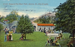
This 1913 postcard view of Fox River Park illustrates why it was so popular. Attractions from enjoying a quiet afternoon to taking a ride on the roller coaster offered entertainment for all. (Little White School Museum collection)

This 1913 postcard view of Fox River Park illustrates why it was so popular. Attractions from enjoying a quiet afternoon to taking a ride on the roller coaster offered entertainment for all. (Little White School Museum collection)

The Western Electric plant, on the west bank of the river across from Boulder Hill, occupied a former wallpaper factory and World War II munitions factory. It was located on the old Riverview Park site, whose name was later changed to Fox River Park to avoid confusion with Chicago’s huge Riverview Park. From 1900 to the mid 1920s, Fox River Park hosted thousands of visitors weekly who enjoyed a roller coaster, merry widow swing, shoot the chutes ride into the river, boat rentals, dances and more. Annual Chautauquas drew thousands more to hear presentations by revivalists and nationally-known speakers. And the ball diamond featured professional players, including one whose name was Casey Stengel.

Along this stretch of the road, it’s always wise to keep a sharp lookout for folks crossing the highway to get to the biking and hiking trail, and I’m also pausing as I let the car in front of me turn into Boulder Hill.

The drive up Memory Lane continues below…


2 Comments

Filed under Fox River, Illinois History, Kendall County, Local History, Nostalgia, Oswego, People in History, Transportation, Uncategorized

A Saturday trip up Memory Lane, Part 2…

Having traveled the route north on Ill. Route 25 thousands of times during my life, it occurred to me last Saturday as I drove it once again that the route is rife with stories, both historical and nostalgic.

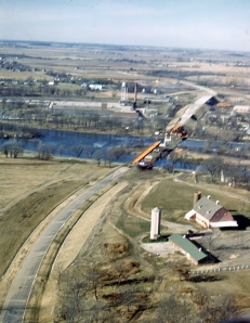
Aerial shot taken by Bev Skaggs in the spring of 1959 of the construction of Paul Egan's By-Pass bridge and Boulder Hill Playhouse. It's lack of sharpness is more than made up for by it's subject matter. (Little White School Museum collection)

Aerial shot taken by Bev Skaggs in the spring of 1959 of the construction of Paul Egan’s By-Pass bridge and Boulder Hill Playhouse. Its lack of sharpness is more than made up for by it’s subject matter. (Little White School Museum collection)

In the previous post, I had made it to the bridge carrying U.S. Route 30 over Route 25 and the Fox River beside it. And that’s where we pick up with this post driving up Memory Lane, right where Aurora Mayor Paul Egan’s former U.S. Route 30 By-Pass crosses the river valley. Egan championed the road, which bypassed downtown Aurora, where Route 30 used to go, to get the growing volume of through truck traffic away from the city’s business district. Although Egan was labeled a nut by his political enemies, his vision concerning By-Pass Route 30 was sound. It was a big success. Eventually, the “By-Pass” part of the name was dropped, as was the “Business Route 30” designation of Galena Boulevard through downtown Aurora, and today the bypass is regular Route 30, the fabled Lincoln Highway.

Route 25 crosses under U.S. Route 30 at the north end of the original Boulder Hill development before passing the Bereman mansion still perched up on the eastern brow of the Fox Valley ridge. John Bereman made his fortune selling freckle cream to complexion-obsessed late Victorian women. He bought hundreds of acres of farmland along the River Road containing several farmsteads, calling the whole operation Boulder Hill Stock Farm—namesake of the modern subdivision. Rumor has it he picked the location of the house because it overlooked an island in the Fox River where a high-class house of ill repute was located in summer months, which men enjoyed while their wives and children cavorted at Fox River Park.

Gray's Bridge at what was then Graytown, eventually Montgomery, as it looked in 1838 when U.S. surveyors passed through. The road from Chicago to Galena crossed the river on the bridge until Aurora officials persuaded officials to move it to pass through Aurora. (State of Illinois Township Survey Map collection)

Gray’s Bridge at what was then Graytown, eventually Montgomery, as it looked in 1838 when U.S. surveyors passed through. The road from Chicago to Galena crossed the river on the bridge until Aurora officials persuaded officials to move it to pass through Aurora. (State of Illinois Township Survey Map collection)

Not far north of the Bereman House is the old location of Gray’s Bridge, one of the earliest bridges across the Fox River. Built by Daniel Gray, entrepreneur and founder of the village of Montgomery, the bridge was to carry stagecoach traffic on the old Chicago to Galena Road that went through Montgomery via the Fox River ford. Aurora tried every trick it could to lure the stage road (and the resulting post office) away from Montgomery, which it succeeded in doing, striking a fatal blow at Montgomery’s development, one from which it has never really recovered.

From the site of Gray’s bridge north to the modern bridge across the Fox in Montgomery, the banks of the river noticeably change, turning more artificial looking, the result of a cockamamie scheme to dredge the river and build a series of more than a dozen low dams to create a navigable motorboat channel from the Illinois River at Ottawa all the way north to the Chain o’ Lakes. One dam in the proposed series was built north of the bridge at Montgomery, where a coin-operated lock was supposed to allow boaters to pass up and down. The lock was never built, and the channel that was to serve it annually turns into a stagnant, sometimes septic mess in the summer.

But before we get to the dam, we drive past what used to be called the French Cemetery, whose modern official name is Sacred Heart Catholic Cemetery. For many years, it was the closest Catholic cemetery to Oswego and the rural area south of Montgomery, and so became the final resting place for most of the many French and French Canadian pioneers who came to the area, including the Hebert wagonwright family of Oswego and the Danos. At least one of the Dano sons became a Catholic priest.

Passing the east end of the Montgomery dam I note there are a number of anglers trying their luck. The dam is a good place to find early season walleyes, as well as smallmouth bass and the occasional northern pike—even a musky once in a while—at other seasons of the year.

We’re getting close to Aurora now, going through the Ashland Avenue intersection, past the Ashland Avenue bridge across the Fox that Aurora Township tried to valiantly a few years ago to persuade everyone it actually belonged to Aurora or the State of Illinois, bridge maintenance being an expensive proposition. Telling anyone who’d listen that it wasn’t their bridge and they had no idea why anyone would think it was didn’t work out, however. The bronze plaque on the bridge announcing it was built by Aurora Township probably didn’t help their case.

The car passes Spring Lake Cemetery, and I’m old enough to remember when there really was a lake there. Long drained, the old lake has become an expansion area of the landlocked cemetery for more graves. A number of my Tesch relatives are buried in Spring Lake, and I always give a mental tip of my hat to those old cousins as I pass.

Now we’re getting into Aurora proper. Workers’ cottages line Route 25—now also called South Broadway—most now home to Hispanic families. Time was, it was an overwhelmingly German neighborhood but times change. And then we pass the old Fruit Juice House. A sort of local franchise business, the Fruit Juice House had locations on South Broadway, over on what was once Route 30 and is now Hill Avenue, on the West Side on Farnsworth, and at other locations around Aurora. The business offered fresh-suqeezed orange and other juices, along with groceries, sort of like a mini-mart. But they also had some of the best ice cream ever, and a Fruit Juice House chocolate malt was a delicacy.

Aurora's "Burlington Box" brick depot was a bustling place in 1968 when this photo was snapped. It was demolished in 2013.

Aurora’s “Burlington Box” brick depot was a bustling place in 1968 when this photo was snapped. After being allowed to deteriorate, it was demolished in 2013.

Driving farther north, we pass the intersection with North Avenue with its tiny octagon house just around the corner and then past the vacant parcel that used to be home to the Aurora depot. The CB&Q built a lot of those pedestrian depots along their Main Line from east to west. Dubbed the “Burlington Box” style, the buildings were utilitarian if not exactly beautiful. Aurora’s depot was allowed to deteriorate until it had to be demolished. It was unfortunate; it would have made a great restaurant location.

I’m continuing north past the old Firestone tire dealer, and under the elevated CB&Q tracks. The Burlington Main Line used to run through Aurora at grade, but in 1920, the tracks were raised to remove them from conflict with surface motor transportation. The viaducts were great places, when we were hotrodding kids, to gun a thinly muffled engine to produce satisfying, echoing thunder.

This color postcard gives an idea of what a vibrant retail area thrived along Aurora's Broadway—Route 25—until Sears, Roebuck & Company led the move of major retailers away from the downtown to shopping centers.

This color postcard gives an idea of what a vibrant retail area thrived along Aurora’s Broadway—Route 25—until Sears, Roebuck & Company led the move of major retailers away from the downtown to shopping centers.

The mix of stores in downtown Aurora has greatly changed over the past 60 years. No more Ward & Jones furniture, no more Sears, Roebuck & Company (where so many farmers shopped for so much on so many Saturday nights). And no more Fagerholm’s where we bought Dinky Toys and great models (including my model of the Cutty Sark); no more Main Surplus across the street where you could get everything from a bowling ball and bag to army surplus web gear. The three five and dime stores, Grants, Woolworth’s, and Kresge’s are long gone as is the lunch counter at Kresge’s where you could get a great BLT.

Passing Galena Boulevard, we’re now on North Broadway to the intersection with New York Street. The old stage route from Naperville across the river to Dixon and on to Galena, the one Sam and Joe McCarty worked so hard to steal from Montgomery, followed sections of both New

Time was, the roundhouse and the Chicago, Burlington & Quincy shops at Aurora turned out locomotives, freight cars, and cabooses for the entire railroad. The roundhouse, now transformed into a banquet center, brew pub and restaurant, is still a local landmark, though greatly repurposed.

Time was, the roundhouse and the Chicago, Burlington & Quincy shops at Aurora turned out locomotives, freight cars, and cabooses for the entire railroad. The roundhouse, now transformed into a banquet center, brew pub and restaurant, is still a local landmark, though greatly repurposed.

York Street and Galena Boulevard. And now the Aurora Transportation Center is in view. The stately old roundhouse is no longer occupied by steam locomotives under construction but rather is the fine dining destination for many area residents. One of the old former CB&Q shop buildings houses the METRA station. My great-grandfather worked in the shops as a stationary steam engineer, while my grandfather worked there building cabooses and boxcars for almost 20 years.

Saturday, however, there were no locomotives in the roundhouse to be turned around or repaired, and the sprawling shops were long gone. Rather, I’m there picking up the grandtwins and my wife, who’ve enjoyed the day in Chicago seeing the dinos and mummys and fossils at the Field Museum and splashing in the fountain at Millennium Park.

I’ve done that drive so many times I can almost do it on automatic pilot these days, but I can never really forget all the stories. It isn’t just a scenic drive, you see, it’s a trip through history.

Leave a comment

Filed under Fox River, Illinois History, Kendall County, Local History, Montgomery, Nostalgia, Oswego, People in History, Transportation

Sea captains! In Kendall County?

When I was a youngster, I was besotted with sailing ships. I built models of the  Sir Thomas Lipton International Fishing Challenge Cup racer Bluenose, the U.S.S. Constitution, and (my masterpiece) the famed clipper ship Cutty Sark.

My most prized possession, a 1958 Christmas present, was my well-thumbed copy of the National Geographic’s Men Ships and the Sea, a collection of true sea stories, the end papers of which featured a full-rigged clipper ship, with all the sails labeled.

We spent hours virtually every summer day on the river back in those days, polling our scows up and down the Fox’s muddy stream, fishing and landing on and exploring nearby islands. One summer, I saved every penny I could and bought 2” diameter poles at Alexander Lumber that I fashioned into a fore-and-aft sailing rig for my scow. I manufactured leeboards and somehow talked my mother into sewing a sail. My little catboat rig actually worked, though tacking across the shallow main channel of the Fox was a real challenge.

During those years I read everything I could that was sailing-related, including C.S. Forester’s wonderful Hornblower saga. Nowadays, what with arthritic fingers and hands, holding books has become a chore, so I rely more and more using the Kindle apps on both my iPhone and MacBook Pro. And imagine my joy when I discovered electronic versions of the Hornblower books! I’m reading them again, in chronological order, using the uBooks app on my iPhone with its nifty auto scroll feature. Every morning during my 21-minute cardio maintenance Nu-Step routine, I let uBooks scroll as I furiously pedal, which makes the time speed by.

So given my fascination with things nautical, I was not a little surprised to run across accounts of two captains with direct Kendall County connections during my epic transcription project. Back when I was editor of the Ledger-Sentinel here in Oswego, I transcribed interesting news items from the Kendall County Record’s “Oswego” news column for our monthly “Yesteryear” feature. I also relied on a bunch of transcriptions Ford Lippold did during 1976, as he sat down at the Oswego Public Library with his portable typewriter transcribing from their microfilm collection. But those transcriptions were extremely incomplete. So when I retired from the news biz in 2008, I decided to fill in the gaps. Over the next five years, I transcribed thousands of news items, mostly dealing with Oswego, from microfilm in the Little White School Museum’s collections. As of this morning, the 70 or so pages of transcriptions Ford and I did prior to 2008 have ballooned to more than 4,700.

But I digress.

Two captains of Great Lakes ships either lived in or had direct connections to our small northern Illinois farming county of Kendall, Capt. John Raleigh and Capt. Frank Huyck. Capt. Raleigh actually owned a 155-acre farm near Yorkville in southwestern Oswego Township, along what is today Ill. Route 71, just south of Van Emmon Road. Every fall, when shipping on the lakes was interrupted by cold weather, Capt. Raleigh would leave his ship and head to his farm. As the Kendall County Record reported on Nov. 10, 1897: “Captain John Raleigh came home Saturday for the winter.” The following April, the Record noted: “Captain Raleigh is away on the lakes for the summer.”

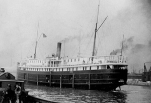
While skippering the steam propeller passenger and freight ship Iowa, Capt. John Raleigh rammed and sank the yacht schooner Hawthorne in August 1896. Photo courtesy http://steamshipphotos.com

While skippering the steam propeller passenger and freight ship Iowa, Capt. John Raleigh rammed and sank the yacht schooner Hawthorne in August 1896. Photo courtesy http://steamshipphotos.com

Capt. Raleigh was apparently not a flawless skipper. August 13, 1896, the Wayne Weekly Breeze reported that “The schooner yacht Hawthorne, owned by McConnell Bros., was sunk off the Government breakwater at the entrance to the Chicago harbor Wednesday night by the single screw propeller [steamer] Iowa of the Goodrich Transportation Line. Capt. Martin Henderson of the yacht and a crew of four were taken off the wreck by the tug Gardner. The big steamer, in charge of Capt. John Raleigh, was on her maiden trip, and proceeded on her way to Grand Haven.” But he must have been good enough, because he enjoyed a long, and relatively successful career.

Capt. Raleigh eventually retired from the lakes, and moved to Yorkville, turning the farm over to his son Ray. He died in 1915 in Chicago at the age of 70 and is buried in the Oswego Township Cemetery beside his wife, Melissa.

Captain Huyck with his cigar (Betty Cornwell collection)

Undated photograph of Capt. Frank Huyck. (Betty Cornwell collection)

Capt. Frank Huyck, on the other hand, apparently never lived in Kendall County, although he visited here frequently after marrying a local girl.

On Feb. 13, 1889, the Kendall County Record reported in its “Oswego” column that “The marriage of Miss Helen Samse to a Mr. Frank Huyck of Sheridan, N.Y. will take place Wednesday at the residence of her parents, Chas. Samse. Helen marries a seafaring man, the mate of a Lake steamer.”

Although busy as first an officer and then as a captain aboard steamers on the lakes, Capt. Huyck managed to get back to visit friends and family once in a while. The Record reported on Sept. 2, 1891 that “Capt. F.B. Huyck came from off the lakes one day to make his wife and baby, who are summering here, a visit.”

By 1903, Capt. Huyck was in command of the Chemung, a passenger and freight steamship owned by the Union Steamship Companies. But in September of that year, the American Association of Masters and Pilots struck against several shipping companies, including the Union Steamship Companies. The companies managed to break the strike a month later and all of the strikers were blackballed from further employment—the captain of the Chemung among them. It would be three years until Huyck would find another job with a Great Lakes shipping company.

In 1906, thanks to his friend, Capt. William Reed, Huyck was offered a job as first mate aboard the steamship Amasa Stone, an ore freighter hauling iron ore from Minnesota’s Messabi Range to steel mills in Ohio. The ore freighter, only a year old, was owned by the newly formed Mesaba Steamship fleet, which was operating under the management of Pickands, Mather & Company. After serving aboard the Stone for a year, Huyck was given command of the brand new freighter Cyprus, whose job it would be to haul coal and iron ore. The 7,400 ton Cyprus, launched on Aug. 17, 1907 at the American Shipbuilding Company, Lorain, Ohio, measured 420 feet in length and was 52 feet wide on the beam.

Louis Pesha photo of the brand new Cyprus, under the command of Capt. Frank Huyck,  in the St. Clair River, upbound for Lake Superior,  on September 22, 1907. (William Forsythe collection)

Louis Pesha photo of the brand new Cyprus, under the command of Capt. Frank Huyck, in the St. Clair River, upbound for Lake Superior, on September 22, 1907. (William Forsythe collection)

One of three sister ships, the Cyprus’s cargo hatches were covered with brand new, recently patented, mechanical covers. Unlike the old wooden hatch covers, the new patent Brousseau telescoping hatch covers could be mechanically retracted using small on-board steam engines much faster and more economically than the old hatch covers. The new hatch covers were considered so superior to the old wooden ones, that the ships with them were not issued canvas tarpaulins used to securely seal the old wooden hatch covers.

But it apparently didn’t take long before the crews of ships with the Brousseau covers became concerned about them. Cyprus made her first voyage on Sept. 7, 1907, up to Lake Superior to load iron ore, and then back down the lakes to Fairport, Ohio. She loaded with coal and headed back upbound to Duluth, Minn., where she delivered the coal before steaming farther north to load with Mesabi iron ore.

While loading ore at Superior, Wis., Huyck was overheard to declare to the Cyprus’s first mate, John Smith, that “I’ll never make another trip without tarps!” Huyck reportedly complained the patent hatch covers did not seal completely around the hatch coamings, which could be dangerous during one of Lake Superior’s frequent strong storms.

On Oct. 10 1907, the Cyprus with Capt. Huyck on the bridge, steamed out of Superior on her way downbound to the southern lakes with 7,100 tons of Mesabi iron ore in her holds. By 10 the next morning, the weather was worsening. The Cyprus was sighted 10 miles south of Stannard Light, west northwest of Whitefish Bay, where she was observed to be rolling in the light swells. When the Cyprus passed the steamer George Stephenson towing the barge Magna through worsening weather conditions about noon, the Stephenson’s Capt. Harbottle, noticed the discharge from the Cyprus‘s bilge pumps was stained red, suggesting that by then the increasingly rough seas were washing over the ship’s decks, over the Brousseau hatches’ low 6” coamings, and into the cargo holds, where the water mixed with some of the soft iron ore before being pumped overboard.

The surface conditions continued to deteriorate, with ships seeking shelter wherever they could. Huyck apparently decided to try to get to the shelter of Whitefish Bay. But like another ore freighter some 60 years in the future—named the Edmund Fitzgerald—the Cyprus wasn’t able to “put 15 more miles behind her” to reach the bay’s shelter. At 7 p.m., Huyck ordered the crew to prepare to abandon ship as she continued to take on water as waves crashed across her deck. At 7:45 p.m., the Cyprus slowly rolled over into the cold waters of Lake Superior and sank in 460 feet of water.

Wreckage of the only Cyprus liferaft to reach shore with the ship's sole survivor, Second Mate Charles Pitz. Capt. Huyck and two other crewmen clung to the raft until overcome by hypothermia in Lake Superior's frigid waters.

Wreckage of the only Cyprus liferaft to reach shore with the ship’s sole survivor, Second Mate Charles Pitz. Capt. Huyck and two other crewmen clung to the storm-tossed raft until overcome by hypothermia in Lake Superior’s frigid waters.

By about 2 a.m. on Oct. 12, the Cyprus’s only surviving life raft, carrying Huyck, First Mate John C. Smith, Second Mate Charles Pitz, and Wheelsman George Thorne, was within sight of the rocky Lake Superior shoreline, despite being flipped over four times by the high waves. Each time, the increasingly exhausted men had managed to clamber back aboard the raft, but when it overturned a fifth time, hypothermia and exhaustion took their toll and only Pitz was able to get back aboard and ride the raft to shore near the Deer Park Life Saving Station, located a little over 16 miles east of Grand Marais, Mich., where he was rescued. Pitz was the only survivor of the Cyprus.

Lake Superior kept Capt. Huyck’s body until finally giving it up a day later when it washed up at the Two Hearted River Life Saving Station at the mouth of Michigan’s Two Hearted River.

After the sinking other ships with Brousseau’s patented hatch covers were all issued tarps. The covers were soon replaced by other telescoping hatch covers invented by Capt. Joseph Kidd. Kidd noted that his hatch covers, as opposed to the Brousseau covers, were “practically water-tight or as nearly so as possible when in place.” In contrast to Brousseau’s hatches, which featured only 6” coamings, Kidd’s hatches had 9″ to 12” coamings, another feature designed to keep water from washing into ore ships’ cargo holds. Kidd’s hatches, though somewhat modified, are still in use today.

Capt. Huyck’s body was taken back to his hometown of Sheridan, N.Y. for burial, where his wife, the former Helen Samse, moved with her children, thus ending one of Kendall County’s more colorful encounters with sea stories.

In a fascinating historical sidelight on the wreck of the Cyprus and Capt. Frank Huyck provided by William Forsythe,

“In August 2007, the Great Lakes Shipwreck Historical Society (GLSHS) sent its research vessel David Boyd to perform a side-scan sonar search near Deer Park, Mich., in Lake Superior. They found a solid target and expected it to be the D. M. Clemson, a mystery ship since her sinking in 1908. Everyone was surprised one week later, on August 18, 2007, when the Shipwreck Society’s Remotely Operated Vehicle (ROV) swam down to film the stern and found the words “CYPRUS FAIRPORT.” The ROV’s dive occurred 100 years and one day after the Cyprus’ launching at the American Shipbuilding Company in Lorain, Ohio.”

For more on the story of the Cyprus and her skipper, go to http://www.boatnerd.com/pictures/historic/Cyprus/


2 Comments

Filed under Illinois History, Kendall County, Local History, People in History, Technology, Transportation

February snow blogging…

Looking out across the Fox River Valley from our second floor bedroom windows, we can see the river has more of its surface frozen over than any time in the last few decades.

Which isn’t surprising given this year’s invasion of the “polar vortex.” Knocked off it’s usual orbit over the Arctic by unusually warm weather in Alaska and Canada, the vortex has spun subzero temperatures down into the Lower 48, all the way south to the Old Confederacy.

Last year, the ice skating rink the Oswegoland Park District maintains on Briarcliff Lake up in Montgomery’s Seasons Ridge Subdivision was scarcely opened a single day. This year, the green “safe” flag has been regularly flying, inviting hardy pleasure and hockey skaters to try their luck.

And because of all that cold weather, the river has finally cooled off enough for much of its surface to freeze. Most recent years, the river only froze sporadically as warmer temperatures and warmer river water meant a free and open stream that thousands of Canada geese and ducks of various species enjoyed. Now, with more and more of the river’s surface covered with ice, the numbers of geese and ducks has decreased a little as they moved elsewhere to find open water.

Mary over at the wonderful Feathers, Fur, and Flowers blog snapped this amazing photo back in mid-January of a group of five Bald Eagles along the Fox. Visit her blog and see lots more truly amazing shots taken along our beautiful stretch of river.

Mary over at the wonderful Feathers, Fur, and Flowers blog snapped this amazing photo back in mid-January of a group of five Bald Eagles along the Fox. Visit her blog and see lots more truly amazing shots taken along our beautiful stretch of river.

The cold also persuaded larger than usual numbers of Bald Eagles to leave their usual wintering grounds along the frozen Illinois and Mississippi rivers to the Fox River Valley in search of enough open water to allow them to fish. With the extended cold spell this winter, there are fewer of the big, distinctive birds, but a few weeks ago, folks were counting them by the dozen on the six-mile stretch between Oswego and Montgomery. Some drivers were so dumbfounded by seeing whole flocks of the giant birds that they simply stopped right in the middle of Ill. Route 25 to gawk.

The good news on the eagle front is that the species has apparently walked back from the brink of extinction. Thanks to bans on DDT and other pesticides that traveled up the food chain to plague the eagle population, we’ve got a breeding pair right here in Oswego. My good friend Glenn watched Mr. and Mrs. Eagle raise their eaglet this year in a nest they built in a tree on an island in the river, easily monitored from Glenn’s upstairs deck.

Time was, there were no eagles around these parts, much less geese and ducks, except the tame ones raised by farmers. We built a blind back in the early 1960s on one of the river’s islands, and tried duck hunting for three years in a row, and never saw a single duck—except the high-flying Vs during the fall and spring migrations. Same with geese; it was a big deal when a flock of the big birds flew over heading north or south, depending on the season. Nowadays, with somewhere north of 60,000 of the giant (and obnoxious) birds living in the Fox Valley full-time, a bunch of the birds flying over doesn’t even rate a second look.

For most of us, the winter’s extreme cold has not been life threatening, so there’s that. We don’t have to worry about freezing temperatures inside our homes as long as we keep sending checks to NiGas and ComEd. But the time was, that wasn’t the case. Back in January 1873, the Kendall County Record reported: “Scores of our people are mourning the loss of cherished house plants by frost during the past week, while a great number have their cellars lumbered with vegetables rendered worthless in like manner.”

And back in that day and age, losing those  vegetables was a big problem, since so many folks depended on canned and otherwise preserved fruits and vegetables from their own gardens and orchards to survive.

Two years later, another extreme cold snap hit Kendall County, with Record editor John R. Marshall reporting: “We have been congratulating ourselves for some time over the mild winter and glorying over the light calls upon the fuel pile. But Old King Winter was not satisfied to let us off so easily and last Friday night with the assistance of Old Boreas, he sent the mercury down to zero—down to ten below; and not yet satisfied Saturday morning, the thermometer indicated from 20 to 25 below, according to location. All the night the wind blew a hurricane and the icy air entered at every crevice. Leaky cellars were no protection to vegetables, and potatoes were icy balls in the morning. Plants were frozen by wholesale and housewives mourned the loss of their favorites.”

The big snow of January 1918 brought most of Northern Illinois to a halt. Trolley and railroad tracks had to be shoveled out by hand, and some communities were cut off for several days.

The big snow of January 1918 brought most of Northern Illinois to a halt. Trolley and railroad tracks had to be shoveled out by hand, and some communities were cut off for several days.

And then there was the big blizzard of January 1918. That year, my grandfather left his home on Hinman Street in Aurora for work at the sprawling Chicago, Burlington & Quincy Railroad shops on South Broadway, and he didn’t get home for two weeks. CB&Q officials loaded every able body they could lay hands on aboard trains and sent them west to hand-shovel the main line.

On Jan. 9, 1918, the Record reported: “The blizzard which visited this part of the country Sunday was one of the most severe in years. The old-timers had a great time telling of what happened in ’48, but the younger ones were satisfied that this storm was a corker. Snow started falling Saturday night and continued with unabated fury all day Sunday and well into the night. A high wind accompanied the snow and filled the roads and walks with immense drifts. Traffic of every kind was stopped except on the Morris line. Superintendent Miller and his crews had cars going all night to avoid a tie-up. Aurora traffic stopped at 10 o’clock on Sunday morning and was not resumed till Tuesday night. One car lay in Yorkville all that time while another was held at Oswego. Trains on the Burlington were delayed and the mail carriers were unable to make their regular trips. Fortunately, the temperature stayed about 20 degrees above zero during the storm. On Tuesday morning, however, the mercury went to 12 below.”

During the Winter of 1979, it got hard to throw the snow high enough to get it over the banks already on the ground. My daughter Melissa is trying her best in this shot, taken at the Matile Manse.

During the Winter of 1979, it got hard to throw the snow high enough to get it over the banks already on the ground. My daughter Melissa is trying her best in this shot, taken at the Matile Manse.

A corker indeed. And, in more modern times, of course, we should not forget the Winter of 1979, when snow became piled so high, it hid entire buildings, not to mention every fire hydrant in town.

Us 21st Century residents have gotten a taste of Old Boreas—the Greek god of the north wind—this year as well, with wind chill warnings regularly reporting temps below -20° F. Nowadays, we have Thinsulate and down-filling and all manner of other modern miracles with which to defeat cold weather. And just like last summer’s high temperatures, we’ll just have to grin and bear the Winter of ‘14 until Boreas or Tom Skilling or someone decides it’s time to warm up a bit around these parts. At least we’ll have something to tell our grandchildren, so there’s that.

Leave a comment

Filed under Fox River, Illinois History, Kendall County, Local History, Montgomery, Nostalgia, Oswego, Semi-Current Events, Transportation

The Winter of the Deep Snow…

It’s still cold here in northern Illinois, and likely to get quite a bit colder. Next Monday, the low is predicted to be -20° F., which is cold in anyone’s book.

There’s quite a bit of snow on the ground, too, with more predicted during the next few days. So far, this has been the snowiest winter around these parts since the big snow of 1978-79.

But when it gets cold like this, most of us are fortunate enough to live in homes with central heat, even if it is costing us an arm and a leg to pay every time the furnace or boiler kicks on.

This year’s weather invites comparisons with some of Illinois’ past memorable winters. And while it’s been cold and snowy, it hasn’t held a candle to the winter of 1830-31, known forever after by the unlucky few pioneer families living in the Fox Valley back then as “The Winter of the Deep Snow.” It was so memorable, in fact, that it became definitive. As historian Jon Musgrave wrote: “The Winter of the Deep Snow became a dating point in pioneer legend. Residence in the Illinois country before that date was qualification for members in Old Settlers associations and special designation as a ‘Snow Bird.’ One pioneer wrote: ‘I have my Snow Bird badge which was given me at the Old Settlers’ meeting at Sugar Grove. I prize it very highly and would not trade it for a hundred wild turkeys running at large in Oregon.’”

According to one account, the really bad weather began with a cold rain on Dec. 20, 1830 which then changed to sleet and snow until a six inch snowfall on Christmas Eve. Then the wind blew, creating huge drifts. Then came more rain and then sub-zero weather, forming a crust atop the snow that in places would bear the weight of men and anilmals In other places, it wasn’t quite thick enough for that and made extremely slow going across the prairie.

Dr. Julian M. Sturtevan of Jacksonville, Ill., kept a journal during the winter and noted that: “For weeks, certainly for not less that two weeks, the mercury in the thermometer tube was not, on any one morning, higher that 12 degrees below zero. The wind was a steady, fierce gale from the northwest, day and night. The air was filled with flying snow, which blinded the eyes and almost stopped the breath of anyone who attempted to face it. No man could, for any considerable length of time, make his way on foot against it.”

As 1830 turned from summer to autumn and then early winter, there were still relatively few hardy pioneers living in the Fox and DuPage River valleys. And none of them were really prepared for the harsh winter that was coming.

Bailey Hobson was one of the earliest settlers in both Kendall and DuPage counties. After weathering the brutal winter of 1830-31, Hobson opened a mill on the DuPage River at Naper's Settlement, now Naperville.

Bailey Hobson was one of the earliest settlers in both Kendall and DuPage counties. After weathering the brutal winter of 1830-31, Hobson opened a mill on the DuPage River at Naper’s Settlement, now Naperville.

Bailey Hobson rode horseback from his home in Orange County, located in southwestern Indiana, to northern Illinois in May 1830, prospecting for land to settle. Armed only with a pocket knife, he looked at land between the Fox and DuPage rivers, eventually selecting a site in the timber below Newark. He cut trees to mark his claim and then headed back to Indiana to get his wife, Clarissa Stewart Hobson, and his children.

Hobson was adventurous, but wasn’t particularly wise about settling during the frontier era. The family didn’t leave Indiana until Sept. 1, 1830, well along in the season. They arrived at Holderman’s Grove in what would one day become Kendall County 21 days later and then traveled to his claim where he built a rude camp for the family while he completed their log cabin.

The family’s supplies were running low, and it was far too late in the season to plant any crops, so Hobson climbed aboard his horse and headed west looking to buy flour. He crossed the Vermilion River and went all the way to the Oxbow Prairie near modern Hennepin, finding no flour to be had, but did find some pork to buy. He promised to return for it later and headed back home, where, although supplies were running low, there was sufficient food for a while.

Even though the food situation was nagging, Hobson continued to prospect for better land. And he found it to the east along the DuPage River. He and his brother-in-law, Lewis Stewart, traveled there in early December and staked a claim with the intent of working on a new cabin. But that night—Dec. 20—the first of what would be a nearly unending string of snow and windstorms struck. The DuPage froze over and Stewart and Hobson had to break the ice and lead their oxen across. It took a few days, but the two exhausted men finally made it back to the Hobson claim where his wife, Clarissa Stewart Hobson was looking after the children and the family’s livestock.

Clarissa Stewart Hobson's iron determination and courage got her children through the Winter of the Deep Snow as her husband left to find food for the family.

Clarissa Stewart Hobson’s iron determination and courage got her children through the Winter of the Deep Snow as her husband left to find food for the family.

It was nearly Christmas, the time Hobson had told the Oxbow people he would return for his pork, and so once again Hobson left his family to head west, leaving Stewart to look after the wife and children. He was gone 19 days, and was nearly lost on the prairie during a blizzard, but finally made it back to the cabin with the pork only to find that his family was down to the last of their corn meal.

It was clear to Hobson that the family needed more provisions or they’d starve. So he and Stewart determined to head off to get provisions elsewhere, leaving Clarissa home to look after the children and livestock. They took a yoke of oxen to break a trail through the snow, leaving 13 head of cattle and three horses for Clarissa to look after, as well as the children.

Two days after the men left, a two day storm dumped three feet of snow on the Hobson claim, followed by a three day windstorm and freezing temperatures. Immediately after the snow fell, Clarissa bundled up and trudged to the nearby spring to get water, but then the hurricane force windstorm hit, and she was forced to dump the water and sprint to safety at the cabin through the wind. The children opened the cabin door for her and then it took all their strength to close it again against the force of the storm. They didn’t go out again for three days.

Before his death in 1850, Bailey Hobson built a large, successful mill on the DuPage River at modern Naperville.

Before his death in 1850, Bailey Hobson built a large, successful mill on the DuPage River at modern Naperville.

When the wind finally stopped, the livestock were nowhere to be found, but they slowly straggled back to the lonely cabin, ha

ving weathered the storm in the lea of the grove where the Hobson cabin stood.

The firewood that had been stockpiled in the cabin had now been exhausted, so Clarissa made her way to the family’s wood pile, only to find it a solid mass of ice. Using a pickax, she was able to free enough wood to keep the cabin’s fire burning. The spring was buried in drifts, but Clarissa was able to melt snow for drinking water.

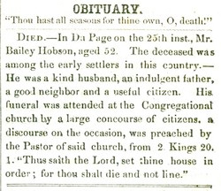
Hobson obitOn the 14th day after he left, Bailey finally returned with part of the provisions he and Stewart had procured. And it was just in time. Clarissa and the children had burned all the wood he and Stewart had stockpiled and Clarissa was in the process of tearing down a log stable and chopping it up for firewood.

Eight days later, Stewart arrived with the rest of the food, the oxen pulling the sledge limping and bleeding from breaking through the crust on top of the snow.

That spring, the Hobsons moved east to their new claim on the DuPage River becoming some of the first settlers in modern Naperville, and some of its most respected residents, having survived The Winter of the Deep Snow.

1 Comment

Filed under Farming, Food, Fox River, Illinois History, Kendall County, Local History, People in History, Transportation

Maybe it really is an old-fashioned winter…

The other day I heard somebody remark that we’re having a real old-fashioned winter this year.

But people have been saying that about northern Illinois winters for decades now.

When this photo was snapped looking east on Washington Street in downtown Oswego about 1914, autos had begun sharing snowy winter roads with farmers' wagons and bobsleds.

When this photo was snapped looking east on Washington Street in downtown Oswego about 1914, autos had begun sharing snowy winter roads with farmers’ wagons and bobsleds.

For instance, in the Dec. 27, 1916 Kendall County Record, editor and publisher Hugh R. Marshall observed: “No one can complain of the good old-fashioned Christmas weather for 1916. Snow on the ground and the thermometer hovering around zero makes one think of the earlier days. But the thing that is missing is the tinkle of sleigh bells. Once in a while you see a sleigh or a bob [sled] go by but little of the jingle that makes one feel that there is some pleasure in the world. The raucous toot of the auto horn and the sound of the open muffler have taken the place of ‘Old Dobbin.’”

About 1916, a mother and child marvel at the interurban trolley as it crosses the frozen Fox River at Oswego while others enjoy skating.

About 1916, a mother and child marvel at the interurban trolley as it crosses the frozen Fox River at Oswego while others enjoy skating.

On Jan. 18, 1922, Marshall returned to the theme: “Kendall county has been experiencing some real, old-fashioned winter weather. The boys and girls are enjoying skating and in many communities the annual ice crop is being harvested. The mercury has threatened zero for several mornings but has not yet reached it. With beautiful sunny days and moonlight nights, no one has worried about the temperature.”

Back in the late 1950s and early 1960s, the Fox Valley experienced some pretty cold, snowy winters, too. Nighttime temperatures dipped to -20° F. and the Fox River froze solid from the warm outflow of the Aurora Sanitary District’s treatment plant at opposite Boulder Hill, all the way south of the Oswego bridge.

This view looking south on Ill. Route 25 at Boulder Hill was taken by Bev Skaggs during the winter of 1959. The river has yet to fully freeze over, but the trees were nicely decorated with hoarfrost.

This view looking south on Ill. Route 25 at Boulder Hill was taken by Bev Skaggs during the winter of 1959. The river has yet to fully freeze over, but the trees were nicely decorated with hoarfrost.

Back in those “old-fashioned” days somewhere around 50 percent of the water in the river was “fresh,” meaning it came from tributaries. Nowadays, somewhere under 20 percent of the river’s water is “fresh,” while 80 percent or more of it has already been used at least once by somebody upstream. With the river’s major tributaries now consisting of sanitary treatment plants of one kind or another, the water is heated sufficiently to keep it from freezing solid.

In addition, until the past few weeks, winter temperatures simply haven’t been as cold as they used to be.

That has drawn lots of new visitors to the river, including tens of thousands of Canada geese, ducks of various species, and, especially this year, whole flocks of Bald Eagles. During the two weeks just past, drivers along Ill. Route 25 reported anywhere from 38 to 61 eagles sitting in trees along the banks of the Fox.

But that’s now. Back in the day, the river froze solid, often for weeks at a time. And that meant great ice-skating. From my neighborhood in Oswego, we could skate south to the U.S. Route 34 bridge in Oswego, even farther if we wanted; and we could skate north all the way to Boulder Hill, as long as we kept near the eastern bank to avoid the ASD plant’s outflow.

The winter of 1979 was a real old-fashioned winter, as this view of the Matile Manse taken that winter suggests. So far, we haven't gotten quite this much snow this year.

The winter of 1979 was a real old-fashioned winter, as this view of the Matile Manse taken that winter suggests. So far, we haven’t gotten quite this much snow this year.

Skating had long been a popular activity on the river. John Marshall, writing in the Kendall County Record on Jan. 13, 1892 noted that: “The ice [company] men were happy over the cold wave that struck this vicinity last week and the young people were also in a good mood because the skating was good.”

It was so popular, in fact, that a move to establish a curfew for young people in Oswego caused much consternation among the ice skating crowd. The Record’s Oswego correspondent reported on Nov. 16, 1898: “Some of the school girls became much alarmed by thinking that the curfew institution would prevent them from moonlight skating after 7:30, but were much relieved when told that the river was outside the corporation and beyond jurisdiction of the marshal.”

Ice-skating was still popular in the 1960s, as I noted above, and not only with us kids who liked skating on the river. Aurora city officials always created an ice rink at Phillips Park to which lots of us would repair in the evening since it was lighted. When the Oswegoland Park District finally built their civic center in Boulder Hill, the parking lot was designed to be flooded in the winter and turned into a skating rink. That lasted until the park board realized that the freeze-thaw cycle was dismantling their parking lot, one crack at a time.

The nice thing about living in river towns like Yorkville and Oswego back then was that there were conveniently located hills kids could use for sledding. Back then, maintenance crews weren’t quite so quick to salt, sand, or cinder-coat municipal streets. As Hugh Marshall, again, wrote in January 1915: “While the coasting on the Bridge street hill has been fine and called out large crowds for several weeks, there were several accidents that lamed some of the young folks.”

In Oswego, street coasting had a fine old history. On Feb. 9, 1887, Record correspondent Lorenzo Rank reported that “Tobogganing was the rage during the last week; there was quite a good natural slide down Benton Street from John Young’s, and crowds of old and young would gather there to engage in the fun or at least witness it. The only accident in connection with it was the spraining of an ear by Roy Pogue.”

Sledding was still popular in 1901on the Benton Street hill. Rank reported that: “Neil, the youngest of Lew young’s boys, broke a leg while coasting, of which he won’t have any more this season but will be all right for playing marbles as he is doing well.”

Although we were unaware of such sledding traditions when we were kids, we unwittingly continued what our grandparents and great-grandparents started. During cold winters, we’d ice down the Second Street hill near my house for particularly good sledding. The trick was to make the curve at the bottom where Second meets North Adams Street, because missing that meant a tree-strewn trip through the woods at the bottom of the hill. Not necessarily safe, but pretty exciting.

These days, things are a lot more structured, and have to be, I suppose, because there so many more people round and about. Ice-skating is impossible on the river, and it’s not often that some civic group will create an outdoor rink like the old Oswego Jaycees did at Boulder Hill School for several years. Sledding has become a more chancy thing, with coasting hills frowned upon due to liability concerns. But after a good snowfall, it’s not too difficult to drive around the area and see folks enjoying some time on the slopes, no matter how gentile they may be, as another Illinois winter does its thing in the Fox River Valley.

Leave a comment

Filed under Fox River, Kendall County, Local History, Nostalgia, Oswego, People in History, Semi-Current Events