
Got word last week that the NaAuSay Township Highway Commissioner plans to pave the last remaining gravel road in the township with a tar-and-chip surface, thus ending a hard-fought transportation era out that direction.
It’s interesting that gravel roads are now considered old technology, when our farming great-grandparents would have done just about anything to have had access to a gravel road back in the 1890s.
Roads here in northern Illinois when the first pioneer farmers began arriving in the late 1820s weren’t much to look at. And I mean that literally. The roads of that era weren’t actually ‘roads,’ but were rather mere tracks and traces across the prairie originally created by bison and other animals that were then adopted by the region’s Native People. It wasn’t for nothing that a synonym for “trail” back in those days was “trace,” because often that’s about all there was, a trace.
 For instance, in March 1831, Juliette Kinzie described a trip she and her Indian trader husband, John, took from Prairie du Chien in modern Wisconsin to Chicago. Because it was so early in the year, the tribes were still in their winter camps, so the normal route, which was basically a straight line from Prairie du Chien to Chicago, was impractical. That’s because all the Indian villages where the party would depend on for food and shelter would be vacant for at least another month. So the plan was to head south to John Dixon’s ferry across the Rock River—modern Dickson, Illinois—and then strike the Great Sauk Trail, the region’s major road used by the Sauk, Fox, and other tribes to make their annual trek to Fort Malden in Canada to trade with the British. The Kinzies made sure they had an experienced guide to help them on their route, with the plan to take the Sauk Trail to the former Fox River Mission in modern Mission Township, LaSalle County, where they’d cross the Fox River and then head northeast to John Naper’s settlement on the DuPage River and then on to Chicago.
But the Kinzies’ experienced guide missed the Great Sauk Trail—the major trail in the region, remember—forcing the party to blunder around before striking the Fox River just south of modern Oswego, where they crossed and then headed to Naper’s settlement—modern Naperville.
There were, of course, other trails and traces used by Native People and pioneers alike, of course, and they became the template on which the region’s first roads were laid. Those roads took the courses of least resistance on their way across the prairie, avoiding the numerous sloughs and other wetlands, generally sticking to high ground, and aiming at the best fords across both the Fox River and its numerous tributaries.

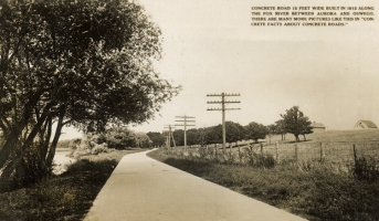
The original stagecoach mail road to Galena (highlighted in red) crossed the Fox River at Montgomery, then bent southwesterly to the ford across Blackberry Creek, before bending northwesterly on its way to Dickson and Galena. It’s a good illustration of a road that pays no attention to township or section lines. Interestingly enough, it still follows this same route 180 years after this map was drawn.
After northern Illinois was officially surveyed by the U.S. Government and the land divided into sections of one squire mile, or 640 acres, and townships were formed from 36 of those sections, it was found the old trail and road system cut inconveniently across those neat boundary lines. As a result, some of those old roads were vacated and their rights-of-way were moved to follow section lines to avoid bisecting farms and towns alike at odd angles. When you fly over the Midwest, you’ll clearly see the survey grid outlined in road rights-of-way. But you’ll also see some roads that still cut across country at varying angles. And when you see them, you’ll be looking at remnants of those old pioneer trails. Here in Kendall County, U.S. Route 34 from Oswego east to Naperville is one of those old trails, as is Ill. Routes 71 from Oswego to Ottawa and 126 from Yorkville to Plainfield, not to mention the best example, Chicago Road, northeast from Lisbon Road through Plattville to Peterson Road, a bonafide old stagecoach and wagon route.
But well after the settlement era ended, the area’s road system continued to mostly consist of dirt roads. Even most streets in town were dirt tracks. And that increasingly caused serious economic problems.

Mr. Ebinger, one of Oswego’s rural mail carriers near the turn of the 20th Century, pauses in town after making his run on his mail route’s muddy roads. (Little White School Museum collection)
As the Kendall County Record reported on April 21, 1881: “The roads out in the country are almost impassable. The mud goes to the wheel hubs.”
The bad roads had both negative economic and sociological effects on county residents. During certain parts of the year, bad roads almost completely isolated farmsteads in some parts of the county. That not only prevented farmers from marketing their livestock and grain, but also cut merchants off from the business farmers gave them.
As the Joliet News reported in March 1890: “The farmers of Will and Kendall counties are just now realizing what public road economy means. Only those living on gravel roads have been in Joliet since before Christmas. Hay, butter, eggs, poultry, and onions have been commanding good prices in this market, and just a few farmers could avail themselves of this condition. The buyer and seller might as well be a thousand miles apart.”
Until 1913, Illinois townships were responsible for financing road construction and for their maintenance outside municipal limits. As noted above, the system barely worked while most travel was by horse-drawn vehicles. By the time the 20th Century dawned and growing numbers of autos and (as they were called at the time) auto trucks, traveled roads, the system was breaking down.
The financing method put unfair burdens on sparsely populated townships. Road mileage might be the same as in heavily populated townships, but more taxpayers helped shoulder the burden.

About 1910, an auto drives north on dusty Main Street, Oswego. Dirt-surfaced roads were the rule in town as well as in the country of that era. (Little White School Museum collection)
Then in 1911, a new state law allowed collection of motor license fees, with the money earmarked for road construction and maintenance. As soon as the state became involved in road financing, they began investigating better construction techniques and better road design. A major benefit of good roads, it turned out, was that it was much cheaper to drive a vehicle on a hard-surfaced road than on a dirt road.
During tests in Cleveland, Ohio, five two-ton White Motor Company trucks with full loads were driven over various road surfaces. They averaged nearly 12 miles per gallon on concrete roads, but less than 6 miles per gallon on dirt roads. Concrete also beat the asphalt roads of the era (9 miles per gallon). Brick roads were nearly as good as concrete, but were labor-intensive to build. Gravel roads, too, were much better than dirt, with a fair gravel surface allowing the trucks to average about 7 mpg, and a good gravel surface giving 9.4 mpg.
So if those driving autos as well as commercial trucks could save so much gasoline, state officials figured, part of that savings could be used to build roads with better surfaces. The calculation went as follows: Assuming the average motorist drove 8,000 miles a year, half over medium to poor roads at eight miles per gallon, over hard roads the mileage would double, saving 250 gallons of gas a year, or $57.50 a year (at the then-current price of 23 cents a gallon). So any annual fee under $57.50 would save motorists money. In the event, auto taxes were figured not to rise to more than $12 a year to fund good roads.
The private Lincoln Highway Association promoted the first coast-to-coast improved highway that was marked with these red, white, and blue badges.
With the advocacy of several groups, including the Kendall County Automobile Club (formed at Plano in 1911), and spearheaded by William G. Edens (namesake of today’s Edens Expressway in Cook County), a statewide organization was formed to lobby for hard roads and to draw up specifications for them.
Edens, a born organizer, started out as a railroad brakeman and conductor who rose to organize the Brotherhood of Railroad Trainmen. Then in 1897, he was tapped by President William McKinley to organize the post office department’s new free delivery system. Leaving government he became a successful Chicago banker, active in Chicago’s social and political scene.
Edens, with the support of Illinois Gov. Edward F. Dunne, helped organize the Illinois Highway Improvement Association, including the association’s first convention in Peoria on Sept. 27, 1912. Each member of the General Assembly was invited, and was also asked to appoint three residents of each legislative district as delegates. Also invited were the state’s agricultural, commercial, labor, banking, real estate, automobile, good roads, medical, rural letter carrier, central women’s club, highway commissioner, teacher, and lawyers’ organizations.
Attending the convention from Kendall County were George S. Faxon of Plano, representing the Illinois Postmasters’ Association; and Dr. R.A. McClelland of Yorkville, representing the Kendall County Automobile Club.
The convention’s platform urged state officials to mandate state and county cooperation in the construction of main highways and bridges, establish a “non political” state highway commission, use state funds to improve main highways connecting county seats and other principal cities, improve other roads controlled by township and county officials, use state prison inmates “when practicable” for road building, and use state automobile taxes to finance the system.
Gov. Dunne, in his 1913 message to the General Assembly, (sounding not unlike the Joliet News of 1890) contended: “The loss to farmers, because of inaccessible primary markets, and the abnormal expense of transportation due to bad roads, must be considered as a contributing cause of the high cost of living. In some Illinois counties, highways are impassable to ordinary loads for a full third of the year.”
Not that it was entirely clear sailing. Township officials opposed loss of their traditional control. But James F. Donovan of Niantic, president of the State Association of Highway Commissioners and Town Clerks, managed to persuade a majority of his group’s members to get on board.
Unsurprisingly, farmers protested the cost and wondered whether better roads would benefit them, but skillful political work at the state, county, and township level blunted their objections. Most decisively, the Illinois State Farmer’s Institute, precursor of today’s Farm Bureau, came out foursquare in favor of good roads, tipping the balance in favor of support.
Later in 1913, a bill featuring many of the good roads convention’s recommendations passed with the support of dozens of organizations. Prominent among them was the Kendall County Automobile Club.
The stretch of modern Ill. Route 25 from the Kane County line south to Oswego was laid down as a concrete demonstration roadway before World War I, the first hard road in Kendall County. (Little White School Museum collection)
Locally, the biggest change following the law’s passage was creating the first county superintendent of highways. John D. Russell of Oswego, a well-known local politician and farmer, was appointed in Kendall County. Russell served as Oswego Township Road Commissioner from 1887-93. In 1896, Gov. John Peter Altgeld appointed Russell his military aide-de-camp, with the rank of colonel. He went on to serve as Oswego Township Supervisor from 1897-1907.
The new legislation made state funds available for hard roads, but there was no overall plan. A short stretch of 15-foot wide concrete roadway—today’s Ill. Route 25—snaked along the east bank of the Fox River south of Montgomery from the Kane County line past the site of what would one day become the Boulder Hill Subdivision to Oswego. Another stretch was built from Yorkville on Van Emmon Road to it’s junction with modern Ill. Route 71. But without a plan to link these isolated stretches, their economic impact was diluted. It would take another governor and more public pressure to create a viable hard road program.
In November 1916, Frank O. Lowden was elected governor and immediately pushed the good roads program begun by Gov. Dunne. “Good roads are a good investment,” Lowden told the General Assembly in January 1917, “Motor vehicles are rapidly supplanting horse-drawn vehicles. When good roads have become the rule, and not the exception as now, auto trucks will likely take the place of horses and wagons in the transportation of the products of the farm.”
Lowden, like Dunne, tapped Edens to organize the new statewide good roads effort. Active members of the association in Kendall County included George Faxon of Plano and Dr. McClelland of Yorkville.
Unfortunately, just as pressure mounted for good roads, the nation plunged into World War I. Even so, on Nov. 5, 1918, while fighting still raged in France, a statewide referendum was held on a $60 million bond issue to build thousands of miles of all-weather concrete roads in Illinois. Led by Edens’ “Pull Illinois Out of the Mud” campaign, the measure easily passed. The vote in Kendall County was an overwhelming 1,532 to 90.
The measure called for improving 800 miles of roads at state and federal expense; improving 4,800 miles of roads with the bond money to be maintained by auto and truck license fees; using joint state-county funding to improve another 11,200 miles of local roads selected by county boards with approval of the state highway commission; and improving 80,000 miles of township roads with counties providing 25 percent of the cost.
The plan called for bond issue concrete roads to pass through all 102 Illinois counties. In Kendall County, Route 18 was to be our hard road. It was to head south out of Aurora on Lincoln Avenue, along the east side of the Fox River through Montgomery to Oswego, then south to Yorkville, across the Fox River to Plano and on to Sandwich and, eventually, Princeton—the route championed for years by the Cannon Ball Trail Association.
But after the referendum passed, Gov. Len Small was elected over Lowden. And when engineers for the Illinois Department of Public Works and Buildings laid out Route 18’s actual right-of-way, a roar of protest went up. Instead of following the route promised during the referendum campaign, the engineers proposed running Route 18 down the west side—not the east side—of the Fox River as an extension of Aurora’s River Street, past the Montgomery sheep yards, and across the Chicago Burlington & Quincy mainline at the Wormley crossing north of Oswego. From there the route headed southwesterly, bypassing Yorkville to the north and Plano’s business district a block or two to the south on a rough airline through Sandwich and on to Princeton. It was the route today of River Street, Ill. Route 31 south to the junction with Route 34 at Oswego, and then on west. Paved spurs were to connect Route 18 with downtowns in Yorkville and Oswego.

Pouring the intersection at modern Ill. Route 31 and U.S. Route 34 in Oswego at the west end of the Oswego bridge across the Fox River in 1924. Photo by Dwight Young in the collections of the Little White School Museum.
The route, the Kendall County Record charged in December 1920, violated several of the requirements laid out in the bond issue legislation. The new route was longer and didn’t use those two sections of concrete road already laid in the county. Further, a costly viaduct over the CB& Q mainline was required at the Wormley crossing.
“In consideration of Route 18, which the state engineers have so arbitrarily placed as to miss Oswego and Yorkville entirely and to abandon a route which was built with the sanction of the state and was to be eventually taken over as Route 18, the question arises as to whether or not the law is being lived up to,” Record Publisher Hugh Marshall complained on Jan. 26, 1921.
Local consensus was that the new route was picked to cater to the meatpacking and other commercial interests of Aurora and Chicago with a direct route favored rather than one that connected local communities.
Despite the protests, state officials insisted on the new route. By the end of September 1921, all the right-of-way had been purchased. Surveying took place in 1923, with actual construction moving ahead in 1924. By late May, the 18-foot wide stretch of concrete pavement had been poured through Oswego to Plano and was curing.

The old iron truss bridge across Waubonsie Creek on today’s Ill. Route 25 was replaced with a concrete bridge in 1924 when the concrete road from Aurora to downtown Oswego was completed. The old bridge was moved downstream to cross the creek at Pearce Cemetery. Little White School Museum collection.
Meanwhile in Oswego, state officials approved connecting the 1915 concrete section of today’s Ill. Route 25 with the Route 18 concrete spur across the Oswego Bridge. In July the state built a new concrete bridge across Waubonsie Creek, and the old iron bridge it replaced was moved to the Pearce Cemetery entrance road. The connection was finished and opened to traffic in early December 1924.
The section of modern Route 34 from Oswego to Naperville had to wait; work didn’t start until the fall of 1932. By October 1933, the road was paved along its entire length, with the exception of the intersection with the Lincoln Highway, today’s U.S. Route 30, and the Elgin Joliet & Eastern Railroad. Not until May 1934 were plans finished to bridge the tracks and to cross under Route 30. The railroad bridge and the highway interchange were not finished until two more years had passed.

The U.S. Route 30-U.S. Route 34 overpass east of Oswego under construction in the summer of 1936. (Little White School Museum collection)
With the end of the project, Route 34‘s course as we now know it was finished, and Kendall County was linked directly with Chicago and western Illinois via a system of all-weather concrete roads.
Meanwhile, out in the county’s rural areas, state and federal funds paid for a variety of road surface improvements and new bridges. And gradually, even totally rural areas like NaAuSay Township were pulled out of the mud.
But gravel roads, too, had their drawbacks, including high maintenance costs as well as draining motorists’ gas mileage and increasing vehicle maintenance costs. So township road commissioners and the county highway department began hard-surfacing rural roads, first with tar and chip and then asphalt to create smooth, all-weather surfaces. These days, Bristol and Oswego townships have no gravel roads at all, and with NaAuSay’s recent announcement, there are none left there, either. The county’s other townships all have a few gravel roads left, but they’re disappearing as the county’s population continues to grow, and its former corn and soybean fields grow increasing numbers of houses instead of crops.
Today, with traffic on Kendall County roads heavier than anyone a century ago could have conceived, we’re still trying to figure out how to maintain a transportation infrastructure that will be of the most value to all area residents.

Great post! Very informative. Can you tell me if the Bereman House is still in existence. I saw a house on Fox Meade Circle in the Reserve that looks like the photo of it that I saw in the Montgomery Patch and it was built in 1908.
Thanks
Yes, that’s the old Bereman House on Fox Meade Circle! Don L. Dise lived there during the development of Boulder Hill. It then stood empty for some years before Primus developed the Reserve. Some folks bought the Bereman place and beautifully restored it. The folks that live there now are either the third or fourth owners since Dise.
Thanks for the information. I appreciate it!
Yeah, that’s the key to happiness. Finding something less worse than the thing you just left. Still, I can’t help but recall a guy who started talking to me in the park one night. He was from Nepal. He said he’d really wanted to go to the U.S., but couldn’t get a visa, so Japan was his second choice. That seems like a strangely random way to wind up here, although I understand it.